Current Weather/Notams (Metars, TAFs, Notams, NWS Forecast, PIREPS, and nearby weather)
Customs Information Send updates to Support@FltPlan.com
Phone 509-762-2667Fax N/AComments 1 hr advance notice required. Business hrs 0800-1700 Monday-Friday.
Database effective 05/16/2024
Airport Diagram might not be current. Facility Name: GRANT COUNTY INTL City Name: MOSES LAKE County: GRANT State abbrev: WA State Name: WASHINGTON Ownership: PUBLICLY OWNED Use: OPEN TO THE PUBLIC Owner's Name: PORT OF MOSES LAKE Address: 7810 ANDREWS STREET NE MOSES LAKE, WA 98837 Owner's Phone: 509-762-5363 Manager's Name: RICH MUELLER; AIRPORT DIRECTOR Address: 7810 ANDREWS STREET NE MOSES LAKE, WA 98837-3204 Phone: 509-762-5363 FAA Region: NORTHWEST MOUNTAIN FAA Field Office: SEA
Runway Identifications Help
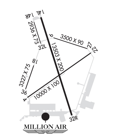
Runway Identification: 04/22 Length: 10000 ftWidth: 100 ftSurface: CONCRETE-GOOD CONDITIONEdge lights: Medium Intensity Treatment: GROOVEDWeight: PCN 92 /R/B/W/T Runway: 04 Runway: 22 Mag heading: 36° Mag heading: 216° Rwy Slope: -.35% Down Rwy Slope: .35% Up Approach: Approach: Pattern: Left Traffic Pattern: Right Traffic Markings: NONPRECISION INSTRUMENT Markings: NONPRECISION INSTRUMENT Marking Condition: GOOD Marking Condition: GOOD Arresting Dev: Arresting Dev: Lat & Long: N4711.8 W11920.0 Lat. & Long.: N4712.8 W11918.0 Elev: 1188.6 ft. MSL Elev: 1153.4 ft. MSL TCH: 49 ft. AGL TCH: 50 ft. AGL Visual Glide Path: 3.00 degrees Visual Glide Path: 3.00 degrees Displaced Threshold: No Displaced Threshold: No Touchdown Zone: YES Touchdown Zone: YES Touchdown Elev.: 1188.6 feet Touchdown Elev.: 1165.6 feet Visual Glide Slope: 4-Light PAPI on LEFT side of Runway Visual Glide Slope: 4-BOX VASI ON LEFT SIDE OF RUNWAY RVR Equipment: RVR Equipment: RVV Equipment: NO RVV Equipment: NO Approach Lights: Approach Lights: REIL: YES REIL: YES Centerline Lights: NO Centerline Lights: NO Touchdown lights: NO Touchdown lights: NO Runway Category: Runway with a Non-precision Approach having visibility minimums greater than 3/4 mile Runway Category: Runway with a Non-precision Approach having visibility minimums greater than 3/4 mile Declared Distances: TORA:10000' TODA:10000' ASDA:10000' LDA:10000' Declared Distances: TORA:10000' TODA:10000' ASDA:10000' LDA:10000'
Runway Identification: 09/27 Length: 3500 ftWidth: 90 ftSurface: CONCRETE-GOOD CONDITIONEdge lights: Non-Standard Lighting System Treatment: GROOVEDWeight: PCN 53 /R/B/W/T Runway: 09 Runway: 27 Mag heading: 90° Mag heading: 270° Rwy Slope: -.27% Down Rwy Slope: .27% Up Approach: Approach: Pattern: Left Traffic Pattern: Right Traffic Markings: Markings: Marking Condition: Marking Condition: Arresting Dev: Arresting Dev: Lat & Long: N4713.1 W11919.0 Lat. & Long.: N4712.9 W11918.2 Elev: 1162.2 ft. MSL Elev: 1152.9 ft. MSL TCH: TCH: Visual Glide Path: Visual Glide Path: Displaced Threshold: No Displaced Threshold: No Touchdown Zone: YES Touchdown Zone: YES Touchdown Elev.: 1162.2 feet Touchdown Elev.: 1160.2 feet Visual Glide Slope: Visual Glide Slope: RVR Equipment: RVR Equipment: RVV Equipment: NO RVV Equipment: NO Approach Lights: Approach Lights: REIL: NO REIL: NO Centerline Lights: NO Centerline Lights: NO Touchdown lights: NO Touchdown lights: NO Runway Category: Runway with a Visual Approach Runway Category: Runway with a Visual Approach Declared Distances: TORA:3500' TODA:3500' ASDA:3500' LDA:3500' Declared Distances: TORA:3500' TODA:3500' ASDA:3500' LDA:3500'
Runway Identification: 14L/32R Length: 13503 ftWidth: 200 ftSurface: CONCRETE-GOOD CONDITIONEdge lights: High Intensity Treatment: GROOVEDWeight: PCN 103/R/B/W/T Runway: 14L Runway: 32R Mag heading: 144° Mag heading: 324° Rwy Slope: -.01% Down Rwy Slope: .01% Up Approach: Approach: ILS Pattern: Left Traffic Pattern: Right Traffic Markings: PRECISION INSTRUMENT Markings: PRECISION INSTRUMENT Marking Condition: GOOD Marking Condition: GOOD Arresting Dev: Arresting Dev: Lat & Long: N4713.5 W11919.6 Lat. & Long.: N4711.4 W11918.6 Elev: 1168.4 ft. MSL Elev: 1166.5 ft. MSL TCH: 75 ft. AGL TCH: 76 ft. AGL Visual Glide Path: 3.00 degrees Visual Glide Path: 3.00 degrees Displaced Threshold: No Displaced Threshold: No Touchdown Zone: YES Touchdown Zone: YES Touchdown Elev.: 1169.2 feet Touchdown Elev.: 1167.3 feet Visual Glide Slope: 4-Light PAPI on LEFT side of Runway Visual Glide Slope: 4-Light PAPI on LEFT side of Runway RVR Equipment: RVR Equipment: RVV Equipment: NO RVV Equipment: YES Approach Lights: Approach Lights: MALSR - 1,400 foot medium intensity approach lighting system with runway alignment indicator lights REIL: YES REIL: NO Centerline Lights: NO Centerline Lights: NO Touchdown lights: NO Touchdown lights: NO Runway Category: Runway with a Non-precision Approach having visibility minimums greater than 3/4 mile Runway Category: Precision Instrument Runway Declared Distances: TORA:13503' TODA:13503' ASDA:13503' LDA:13503' Declared Distances: TORA:13503' TODA:13503' ASDA:13492' LDA:13492' Obstructions: BLDG Obstructions: Marked: MARKED and LIGHTED Marked: Clearance slope: 35:1 Clearance slope: 50:1 Obstruction height: 25 feet AGL Obstruction height: Dist. from runway: 1081 feet Dist. from runway: Centerline offset: Centerline offset: Comments: Comments:
Runway Identification: 14R/32L Length: 2936 ftWidth: 75 ftSurface: CONCRETE-GOOD CONDITIONEdge lights: Treatment: NONEWeight: PCN 107/R/B/W/T Runway: 14R Runway: 32L Mag heading: 144° Mag heading: 324° Rwy Slope: .06% Up Rwy Slope: -.06% Down Approach: Approach: Pattern: Right Traffic Pattern: Left Traffic Markings: BASIC Markings: BASIC Marking Condition: GOOD Marking Condition: GOOD Arresting Dev: Arresting Dev: Lat & Long: N4713.4 W11919.8 Lat. & Long.: N4713.0 W11919.6 Elev: 1167.8 ft. MSL Elev: 1169.6 ft. MSL TCH: TCH: Visual Glide Path: Visual Glide Path: Displaced Threshold: No Displaced Threshold: No Touchdown Zone: YES Touchdown Zone: YES Touchdown Elev.: 1169.6 feet Touchdown Elev.: 1169.6 feet Visual Glide Slope: Visual Glide Slope: RVR Equipment: RVR Equipment: RVV Equipment: NO RVV Equipment: NO Approach Lights: Approach Lights: REIL: NO REIL: NO Centerline Lights: NO Centerline Lights: NO Touchdown lights: NO Touchdown lights: NO Runway Category: Runway with a Visual Approach Runway Category: Runway with a Visual Approach Declared Distances: TORA:2936' TODA:2936' ASDA:2936' LDA:2936' Declared Distances: TORA:2936' TODA:2936' ASDA:2936' LDA:2936' Obstructions: GND Obstructions: Marked: NOT Marked/Lighted Marked: Clearance slope: 46:1 Clearance slope: 50:1 Obstruction height: 9 feet AGL Obstruction height: Dist. from runway: 620 feet Dist. from runway: Centerline offset: 100 right of centerline Centerline offset: Comments: Comments:
Runway Identification: 18/36 Length: 3327 ftWidth: 75 ftSurface: ASPHALT-GOOD CONDITIONEdge lights: Medium Intensity Treatment: NONEWeight: PCN 112/F/A/W/T Runway: 18 Runway: 36 Mag heading: 180° Mag heading: 0° Rwy Slope: -.01% Down Rwy Slope: .01% Up Approach: Approach: Pattern: Right Traffic Pattern: Left Traffic Markings: BASIC Markings: BASIC Marking Condition: GOOD Marking Condition: GOOD Arresting Dev: Arresting Dev: Lat & Long: N4712.5 W11919.8 Lat. & Long.: N4712.0 W11920.0 Elev: 1185.1 ft. MSL Elev: 1184.8 ft. MSL TCH: TCH: Visual Glide Path: Visual Glide Path: Displaced Threshold: No Displaced Threshold: No Touchdown Zone: YES Touchdown Zone: YES Touchdown Elev.: 1185.1 feet Touchdown Elev.: 1185.1 feet Visual Glide Slope: Visual Glide Slope: RVR Equipment: RVR Equipment: RVV Equipment: NO RVV Equipment: NO Approach Lights: Approach Lights: REIL: NO REIL: NO Centerline Lights: NO Centerline Lights: NO Touchdown lights: NO Touchdown lights: NO Runway Category: Runway with a Visual Approach Runway Category: Runway with a Visual Approach Declared Distances: Declared Distances: