These numbers are Advisory and are not limits. The Airport Manager should have more accurate Weight Limits
Approach Charts
Current Weather/Notams (Metars, TAFs, Notams, NWS Forecast, PIREPS, and nearby weather)
Customs Information Send updates to Support@FltPlan.com
Phone 985-632-8182 Fax 985-632-8185
Comments Hours of operation are Mon-Fri 8:00AM-4:30PM. *48 hours advanced notice* After hours are appointment only. Must call ahead for appointments after 4:30PM. Sat and Sun 8:00AM-4:00PM by appointment only. Private flights have to be US Citizens or Greencard holders. No user fee but must have decal. Commercial and other handled through New Orleans.
Sunrise / Sunset times for LAFAYETTE RGNL/PAUL FOURNET FLD
Date
Sunrise
Sunset
04/25/24 Thursday
6:30
19:42
04/26/24 Friday
6:29
19:43
04/27/24 Saturday
6:28
19:44
04/28/24 Sunday
6:27
19:44
04/29/24 Monday
6:26
19:45
04/30/24 Tuesday
6:25
19:46
05/01/24 Wednesday
6:24
19:46
05/02/24 Thursday
6:23
19:47
05/03/24 Friday
6:22
19:48
05/04/24 Saturday
6:22
19:48
05/05/24 Sunday
6:21
19:49
05/06/24 Monday
6:20
19:49
05/07/24 Tuesday
6:19
19:50
05/08/24 Wednesday
6:18
19:51
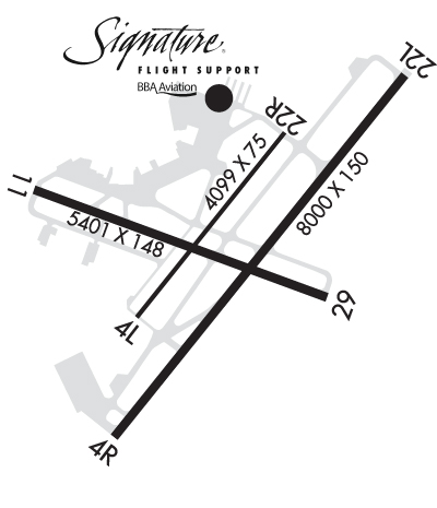
Airport Facilities
Airport Attendance Schedule
CONTINUOUS
Airport Status
OPERATIONAL (This Status can change at any time - please check NOTAMS)
Airport Lighting Schedule
DUSK-DAWN. WHEN ATCT CLSD ACTVT MALSR RWY 22L - CTAF; MIRL RWY 04L/22R NOT AVBL.
Airport Storage Available
Tie Downs, Hanger
Extra Services Available
Air Freight, Air Ambulance, Avionics, Cargo Handling, Charter, Flight Instruction, Aircraft Rental, Aircraft Sales
Wind Indicator
YES - (lighted)
Control Tower
YES
CTAF Frequency
118.500
Unicom Frequency
122.950
Rotating Beacon Color
WG
Segmented Circle
YES
Landing Fee
Airport Inspection Data
Airport Inspected
FEDERAL - performed by FAA AIRPORTS FIELD PERSONNEL
Inspection Date
02/02/2024
Airport Services
Type of Fuel Available
Grade 100LL, JET A (freeze point -40C), JET A; -A+CALL 337-234-3100.
Airframe Repair Service
MAJOR
Power Plant Repair Service
MAJOR
Geographic Data
Latitude
N3012.3
Longitude
W09159.3 (ESTIMATED)
Arpt Elevation
41ft (SURVEYED)
Magnetic Variation
03E
2 miles SE
of LAFAYETTE
Traffic Pattern Altitude
Sectional Chart
HOUSTON
Aircraft Data
Operations (Reported)
Yearly
Avg. Daily
General Aviation Transient
18604
51
General Aviation Local
7017
19
Air Taxi
9283
25
Commerical
7247
20
Commuter
0
0
Military
699
2
Aircraft based on Field
General Aviation Singles
66
General Aviation Multi
14
Jet Aircraft
31
General Aviation Helicopters
5
Military Aircraft
0
Gliders
0
Ultralights
0
FAA Services
FSS on field
NO
FSS tie-in
DE RIDDER
FSS Phone
1-800-WX-BRIEF
Who issues Notams
LFT
Notam D service at airport
YES
ARTCC Name
HOUSTON
Federal Status
Airport Certification
AIRPORT RECEIVING SCHEDULED AIR CARRIER SERVICE FROM CARRIERS CERTIFICATED BY THE CIVIL AERONAUTICS BOARD; PPR FOR UNSCHEDULED ACR OPNS WITH MORE THAN 30 PSGR SEATS CALL AMGR 337-703-4800.
Aircraft Rescue & Firefighting Index
AIRPORT HAS A CERTIFICATE UNDER CFR PART 139
Airport of Entry
No
Custom Landing Rights
YES
Joint Civil/Military
No
Military Landing rights
YES
Federal Agreements
NATIONAL PLAN OF INTEGRATED AIRPORT SYSTEMS (NPIAS)
GRANT AGREEMENTS UNDER FAAP/ADAP/AIP
SURPLUS PROPERTY AGREEMENT UNDER PUBLIC LAW 289
ASSURANCES PURSUANT TO TITLE VI, CIVIL RIGHTS ACT OF 1964