Current Weather/Notams (Metars, TAFs, Notams, NWS Forecast, PIREPS, and nearby weather)
Customs Information Send updates to Support@FltPlan.com
Customs Not Available
Database effective 05/16/2024
Airport Diagram might not be current. Facility Name: SAN MARCOS RGNL City Name: AUSTIN County: CALDWELL State abbrev: TX State Name: TEXAS Ownership: PUBLICLY OWNED Use: OPEN TO THE PUBLIC Owner's Name: CITY OF SAN MARCOS Address: 630 E. HOPKINS STREET SAN MARCOS, TX 78666 Owner's Phone: 512-216-6039 Manager's Name: CASSIDY BERENATO; CASSIDY BERENATO Address: 4400 HWY 21, SUITE 200 SAN MARCOS, TX 78666 Phone: 512-216-6039; EMERG CTC: CITY OF SAN MARCOS POLICE DISPATCH - 512-753-2108 FAA Region: SOUTHWEST FAA Field Office: TEX
Runway Identifications Help
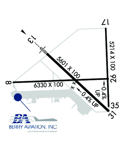
Runway Identification: 08/26 Length: 6330 ftWidth: 100 ftSurface: ASPHALT-GOOD CONDITIONEdge lights: Medium Intensity Treatment: NONE Runway: 08 Runway: 26 Mag heading: 81° Mag heading: 261° Rwy Slope: -.12% Down Rwy Slope: .12% Up Approach: Approach: Pattern: Left Traffic Pattern: Left Traffic Markings: NONPRECISION INSTRUMENT Markings: NONPRECISION INSTRUMENT Marking Condition: FAIR Marking Condition: FAIR Arresting Dev: Arresting Dev: Lat & Long: N2953.5 W09752.6 Lat. & Long.: N2953.5 W09751.4 Elev: 587.8 ft. MSL Elev: 580.0 ft. MSL TCH: TCH: Visual Glide Path: Visual Glide Path: Displaced Threshold: No Displaced Threshold: No Touchdown Zone: YES Touchdown Zone: YES Touchdown Elev.: 589.3 feet Touchdown Elev.: 586.8 feet Visual Glide Slope: Visual Glide Slope: RVR Equipment: RVR Equipment: RVV Equipment: NO RVV Equipment: NO Approach Lights: Approach Lights: REIL: NO REIL: NO Centerline Lights: NO Centerline Lights: NO Touchdown lights: NO Touchdown lights: NO Runway Category: D Runway Category: D Declared Distances: Declared Distances: Obstructions: FENCE Obstructions: CROPS Marked: NOT Marked/Lighted Marked: NOT Marked/Lighted Clearance slope: Clearance slope: Obstruction height: 6 feet AGL Obstruction height: 8 feet AGL Dist. from runway: 201 feet Dist. from runway: 205 feet Centerline offset: 360 left of centerline Centerline offset: Comments: 6 FT FENCE 130-199 FT DSTC, 360 FT L. Comments:
Runway Identification: 13/31 Length: 5601 ftWidth: 100 ftSurface: ASPHALT-GOOD CONDITIONEdge lights: Medium Intensity Treatment: NONE Runway: 13 Runway: 31 Mag heading: 126° Mag heading: 306° Rwy Slope: -.35% Down Rwy Slope: .35% Up Approach: ILS Approach: Pattern: Left Traffic Pattern: Left Traffic Markings: PRECISION INSTRUMENT Markings: PRECISION INSTRUMENT Marking Condition: GOOD Marking Condition: GOOD Arresting Dev: Arresting Dev: Lat & Long: N2953.8 W09752.2 Lat. & Long.: N2953.2 W09751.4 Elev: 593.1 ft. MSL Elev: 573.4 ft. MSL TCH: 57 ft. AGL TCH: 60 ft. AGL Visual Glide Path: 3.00 degrees Visual Glide Path: 3.00 degrees Displaced Threshold: No Displaced Threshold: No Touchdown Zone: YES Touchdown Zone: YES Touchdown Elev.: 593.3 feet Touchdown Elev.: 583.3 feet Visual Glide Slope: 2-Light PAPI on LEFT side of Runway Visual Glide Slope: 2-Light PAPI on LEFT side of Runway RVR Equipment: RVR Equipment: RVV Equipment: NO RVV Equipment: NO Approach Lights: MALS - 1,400 foot medium intensity approach lighting system Approach Lights: REIL: NO REIL: NO Centerline Lights: NO Centerline Lights: NO Touchdown lights: NO Touchdown lights: NO Runway Category: Precision Instrument Runway Runway Category: Runway with a Non-precision Approach having visibility minimums greater than 3/4 mile Declared Distances: Declared Distances: Obstructions: Obstructions: TREES Marked: Marked: NOT Marked/Lighted Clearance slope: 50:1 Clearance slope: 31:1 Obstruction height: Obstruction height: 64 feet AGL Dist. from runway: Dist. from runway: 2200 feet Centerline offset: Centerline offset: Comments: Comments:
Runway Identification: 17/35 Length: 5214 ftWidth: 100 ftSurface: ASPHALT-GOOD CONDITIONEdge lights: Medium Intensity Treatment: NONE Runway: 17 Runway: 35 Mag heading: 171° Mag heading: 351° Rwy Slope: -.37% Down Rwy Slope: .37% Up Approach: Approach: Pattern: Left Traffic Pattern: Left Traffic Markings: NONPRECISION INSTRUMENT Markings: NONPRECISION INSTRUMENT Marking Condition: FAIR Marking Condition: FAIR Arresting Dev: Arresting Dev: Lat & Long: N2954.1 W09751.5 Lat. & Long.: N2953.2 W09751.4 Elev: 594.5 ft. MSL Elev: 575.0 ft. MSL TCH: 55 ft. AGL TCH: Visual Glide Path: 3.00 degrees Visual Glide Path: Displaced Threshold: No Displaced Threshold: No Touchdown Zone: YES Touchdown Zone: YES Touchdown Elev.: 594.7 feet Touchdown Elev.: 582.9 feet Visual Glide Slope: 2-Light PAPI on LEFT side of Runway Visual Glide Slope: RVR Equipment: RVR Equipment: RVV Equipment: NO RVV Equipment: NO Approach Lights: Approach Lights: REIL: NO REIL: NO Centerline Lights: NO Centerline Lights: NO Touchdown lights: NO Touchdown lights: NO Runway Category: Runway with a Non-precision Approach having visibility minimums greater than 3/4 mile Runway Category: D Declared Distances: Declared Distances: