Current Weather/Notams (Metars, TAFs, Notams, NWS Forecast, PIREPS, and nearby weather)
Customs Information Send updates to Support@FltPlan.com
Phone 956-542-8296Fax N/AComments Mon-Fri 0800-1700 *1 hr advance notice required *Emergency use only
Database effective 05/16/2024
Airport Diagram might not be current. Facility Name: VALLEY INTL City Name: HARLINGEN County: CAMERON State abbrev: TX State Name: TEXAS Ownership: PUBLICLY OWNED Use: OPEN TO THE PUBLIC Owner's Name: CITY OF HARLINGEN Address: PO BOX 2207 HARLINGEN, TX 78550-2207 Owner's Phone: (956) 430-8605 Manager's Name: MARV ESTERLY Address: AIRPORT TERMINAL BUILDING,, 3002 HE, 3200 HERITAGE WAY HARLINGEN, TX 78550 Phone: 956-430-8605 FAA Region: SOUTHWEST FAA Field Office: TEX
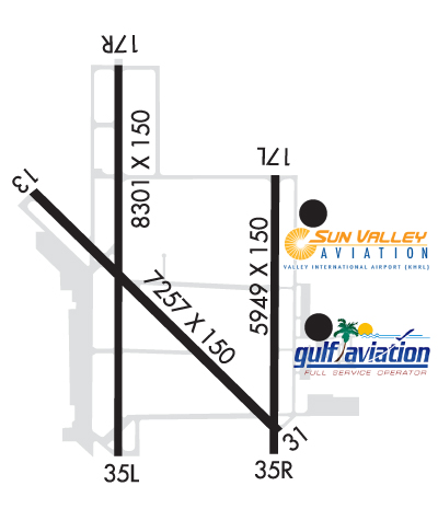
Runway Identifications Help
Runway Identification: 13/31 Length: 7257 ftWidth: 150 ftSurface: ASPHALT-GOOD CONDITIONEdge lights: High Intensity Treatment: GROOVED Runway: 13 Runway: 31 Mag heading: 131° Mag heading: 311° Rwy Slope: .02% Up Rwy Slope: -.02% Down Approach: Approach: Pattern: Left Traffic Pattern: Left Traffic Markings: PRECISION INSTRUMENT Markings: PRECISION INSTRUMENT Marking Condition: GOOD Marking Condition: GOOD Arresting Dev: Arresting Dev: Lat & Long: N2614.0 W09739.8 Lat. & Long.: N2613.1 W09738.9 Elev: 34.4 ft. MSL Elev: 35.7 ft. MSL TCH: 59 ft. AGL TCH: 55 ft. AGL Visual Glide Path: 3.00 degrees Visual Glide Path: 3.00 degrees Displaced Threshold: No Displaced Threshold: No Touchdown Zone: YES Touchdown Zone: YES Touchdown Elev.: 34.8 feet Touchdown Elev.: 35.9 feet Visual Glide Slope: 4-Light PAPI on LEFT side of Runway Visual Glide Slope: 4-Light PAPI on LEFT side of Runway RVR Equipment: RVR Equipment: RVV Equipment: NO RVV Equipment: NO Approach Lights: Approach Lights: MALSR - 1,400 foot medium intensity approach lighting system with runway alignment indicator lights REIL: YES REIL: NO Centerline Lights: NO Centerline Lights: NO Touchdown lights: NO Touchdown lights: NO Runway Category: Runway with a Non-precision Approach having visibility minimums greater than 3/4 mile Runway Category: Runway with a Non-precision Approach having visibility minimums greater than 3/4 mile Declared Distances: TORA:7257' TODA:7257' ASDA:7257' LDA:7257' Declared Distances: TORA:7257' TODA:7257' ASDA:7257' LDA:7257'
Runway Identification: 17L/35R Length: 5949 ftWidth: 150 ftSurface: ASPHALT-GOOD CONDITIONEdge lights: Medium Intensity Treatment: NONE Runway: 17L Runway: 35R Mag heading: 176° Mag heading: 356° Rwy Slope: .02% Up Rwy Slope: -.02% Down Approach: Approach: Pattern: Left Traffic Pattern: Right Traffic Markings: PRECISION INSTRUMENT Markings: PRECISION INSTRUMENT Marking Condition: GOOD Marking Condition: GOOD Arresting Dev: Arresting Dev: Lat & Long: N2614.0 W09738.9 Lat. & Long.: N2613.1 W09738.9 Elev: 33.8 ft. MSL Elev: 35.0 ft. MSL TCH: TCH: Visual Glide Path: Visual Glide Path: Displaced Threshold: No Displaced Threshold: 190 feet Touchdown Zone: YES Touchdown Zone: YES Touchdown Elev.: 34.4 feet Touchdown Elev.: 35.8 feet Visual Glide Slope: Visual Glide Slope: RVR Equipment: RVR Equipment: RVV Equipment: NO RVV Equipment: NO Approach Lights: Approach Lights: REIL: YES REIL: NO Centerline Lights: NO Centerline Lights: NO Touchdown lights: NO Touchdown lights: NO Runway Category: Runway with a Non-precision Approach having visibility minimums greater than 3/4 mile Runway Category: Runway with a Non-precision Approach having visibility minimums greater than 3/4 mile Declared Distances: TORA:5949' TODA:5949' ASDA:5949' LDA:5949' Declared Distances: TORA:5949' TODA:5949' ASDA:5949' LDA:5759'
Runway Identification: 17R/35L Length: 8301 ftWidth: 150 ftSurface: ASPHALT-GOOD CONDITIONEdge lights: High Intensity Treatment: GROOVED Runway: 17R Runway: 35L Mag heading: 176° Mag heading: 356° Rwy Slope: .02% Up Rwy Slope: -.02% Down Approach: ILS/DME Approach: Pattern: Right Traffic Pattern: Left Traffic Markings: PRECISION INSTRUMENT Markings: PRECISION INSTRUMENT Marking Condition: GOOD Marking Condition: GOOD Arresting Dev: Arresting Dev: Lat & Long: N2614.4 W09739.5 Lat. & Long.: N2613.1 W09739.5 Elev: 34.0 ft. MSL Elev: 35.7 ft. MSL TCH: TCH: 59 ft. AGL Visual Glide Path: Visual Glide Path: 3.00 degrees Displaced Threshold: No Displaced Threshold: No Touchdown Zone: YES Touchdown Zone: YES Touchdown Elev.: 34.6 feet Touchdown Elev.: 36.3 feet Visual Glide Slope: Visual Glide Slope: 4-Light PAPI on RIGHT side of Runway RVR Equipment: RVR Equipment: RVV Equipment: NO RVV Equipment: NO Approach Lights: MALSR - 1,400 foot medium intensity approach lighting system with runway alignment indicator lights Approach Lights: REIL: NO REIL: NO Centerline Lights: NO Centerline Lights: NO Touchdown lights: NO Touchdown lights: NO Runway Category: Precision Instrument Runway Runway Category: Runway with a Non-precision Approach having visibility minimums greater than 3/4 mile Declared Distances: TORA:8301' TODA:8301' ASDA:8301' LDA:8301' Declared Distances: TORA:8301' TODA:8301' ASDA:8301' LDA:8301'