Current Weather/Notams (Metars, TAFs, Notams, NWS Forecast, PIREPS, and nearby weather)
Customs Information Send updates to Support@FltPlan.com
Customs Not Available
Database effective 05/16/2024
Airport Diagram might not be current.
|
| Facility Name: | LEE GILMER MEML |
| City Name: | GAINESVILLE |
| County: | HALL |
| State abbrev: | GA |
| State Name: | GEORGIA |
| | |
| Ownership: | PUBLICLY OWNED |
| Use: | OPEN TO THE PUBLIC |
| Owner's Name: | CITY OF GAINESVILLE |
| Address: | P.O. BOX 2496 |
| | GAINESVILLE, GA 30501 |
| Owner's Phone: | 770-535-6882 |
| | |
| Manager's Name: | LISA POOLE |
| Address: | PO BOX 2496 |
| | GAINESVILLE, GA 30503-2496 |
| Phone: | 770-535-6882 |
| | |
| FAA Region: | SOUTHERN |
| FAA Field Office: | ATL |
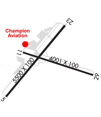
Runway Identifications
Runway Identification: 05/23Length: 5496 ft
Width: 100 ft
Surface: ASPHALT-FAIR CONDITION
Edge lights: High IntensityTreatment: GROOVED
| | Runway: 05 | | Runway: 23 |
| Mag heading: | 44° | Mag heading: | 224° |
| Rwy Slope: | -.67% Down | Rwy Slope: | .67% Up |
| Approach: | ILS/DME | Approach: | |
| Pattern: | Left Traffic | Pattern: | Left Traffic |
| Markings: | PRECISION INSTRUMENT | Markings: | PRECISION INSTRUMENT |
| Marking Condition: | GOOD | Marking Condition: | GOOD |
| Arresting Dev: | | Arresting Dev: | |
| Lat & Long: | N3416.0 W08350.3 | Lat. & Long.: | N3416.7 W08349.6 |
| Elev: | 1274.3 ft. MSL | Elev: | 1237.5 ft. MSL |
| TCH: | 30 ft. AGL | TCH: | 38 ft. AGL |
| Visual Glide Path: | 3.00 degrees | Visual Glide Path: | 3.00 degrees |
| Displaced Threshold: | No | Displaced Threshold: | 396 feet |
| Touchdown Zone: | YES | Touchdown Zone: | YES |
| Touchdown Elev.: | 1275.3 feet | Touchdown Elev.: | 1273.8 feet |
| Visual Glide Slope: | 2-Light PAPI on RIGHT side of Runway | Visual Glide Slope: | 2-Light PAPI on LEFT side of Runway |
| RVR Equipment: | | RVR Equipment: | |
| RVV Equipment: | NO | RVV Equipment: | NO |
| Approach Lights: | MALSR - 1,400 foot medium intensity approach lighting system with runway alignment indicator lights | Approach Lights: | |
| REIL: | NO | REIL: | NO |
| Centerline Lights: | NO | Centerline Lights: | NO |
| Touchdown lights: | NO | Touchdown lights: | NO |
| Runway Category: | Precision Instrument Runway | Runway Category: | Runway with a Non-precision Approach having visibility minimums greater than 3/4 mile |
| Declared Distances: | TORA:5496' TODA:5496' ASDA:5370' LDA:5370' | Declared Distances: | TORA:5496' TODA:5496' ASDA:5496' LDA:5100' |
| Obstructions: | TREES | Obstructions: | TREES |
| Marked: | NOT Marked/Lighted | Marked: | NOT Marked/Lighted |
| Clearance slope: | 3:1 | Clearance slope: | 8:1; APCH 27:1 TO DSPLCD THLD. |
| Obstruction height: | 23 feet AGL | Obstruction height: | 59 feet AGL |
| Dist. from runway: | 269 feet | Dist. from runway: | 672 feet |
| Centerline offset: | 493 left of centerline | Centerline offset: | 408 feet left of centerline |
| Comments: | | Comments: | BLDG 360 FT LEFT 0 FT - 80 FT FROM EOR. |
Runway Identification: 11/29Length: 4003 ft
Width: 100 ft
Surface: ASPHALT-FAIR CONDITION
Edge lights: Treatment: NONE
| | Runway: 11 | | Runway: 29 |
| Mag heading: | 111° | Mag heading: | 291° |
| Rwy Slope: | -.32% Down | Rwy Slope: | .32% Up |
| Approach: | | Approach: | |
| Pattern: | Left Traffic | Pattern: | Left Traffic |
| Markings: | BASIC | Markings: | BASIC |
| Marking Condition: | GOOD | Marking Condition: | GOOD |
| Arresting Dev: | | Arresting Dev: | |
| Lat & Long: | N3416.4 W08350.0 | Lat. & Long.: | N3416.2 W08349.3 |
| Elev: | 1272.8 ft. MSL | Elev: | 1259.9 ft. MSL |
| TCH: | | TCH: | |
| Visual Glide Path: | | Visual Glide Path: | |
| Displaced Threshold: | 120 feet | Displaced Threshold: | 111 feet |
| Touchdown Zone: | YES | Touchdown Zone: | YES |
| Touchdown Elev.: | 1276.9 feet | Touchdown Elev.: | 1276.9 feet |
| Visual Glide Slope: | | Visual Glide Slope: | |
| RVR Equipment: | | RVR Equipment: | |
| RVV Equipment: | NO | RVV Equipment: | NO |
| Approach Lights: | | Approach Lights: | |
| REIL: | NO | REIL: | NO |
| Centerline Lights: | NO | Centerline Lights: | NO |
| Touchdown lights: | NO | Touchdown lights: | NO |
| Runway Category: | Runway with a Visual Approach | Runway Category: | Runway with a Visual Approach |
| Declared Distances: | TORA:4001' TODA:4001' ASDA:3881' LDA:3770' | Declared Distances: | TORA:4001' TODA:4001' ASDA:3890' LDA:3770' |
| Obstructions: | TREES | Obstructions: | TREES |
| Marked: | NOT Marked/Lighted | Marked: | NOT Marked/Lighted |
| Clearance slope: | 1:1 | Clearance slope: | 7:1 |
| Obstruction height: | 42 feet AGL | Obstruction height: | 42 feet AGL |
| Dist. from runway: | 242 feet | Dist. from runway: | 494 feet |
| Centerline offset: | 111 left of centerline | Centerline offset: | 149 feet right of centerline |
| Comments: | | Comments: | |