KGNV

GAINESVILLE RGNL
GAINESVILLE
FL
Time Zone: Eastern
Lat: N 2941.4
Long: W 08216.3
Elev: 151
Var: +04
Longest Runway: 7504
Dept. ATIS: 127.15
Arr. ATIS: 127.15
AWOS: 127.15
Ground: 121.7
Tower: 119.55
Click here for more info.

FBO & Flight Services info for KGNV

FBOs: Update your Fuel Prices

UNIVERSITY AIRPh: 352-335-4681 Fax: 352-338-0593 Freq: 122.95
Service
Jet
100LL
SAF
MoGas
Fuel Avail: 24/7
Full5.916.72    Last Update: 04/23/2024 10:38

Self  6.07    
 Address: 4701 NE 40TH TERR   GAINESVILLE, FL 32609
AWOSPh: 352-335-8672
-
-
 
If you are an FBO, call 1-203-262-1700 to update your info or email: FltPlan.Advertising@garmin.com
Advertise your FBO on FltPlan.com

Runway & Approach Info for KGNV
Rwy
Length
Land Dist**
Approach*
  Rwy
Length
Land Dist**
Approach*
07
4158x100  4158'          
 
  
25
  4158x100  4158'          
 
11
7504x150  7504'          
 
  
29
  7504x150  7504'          
ILS
 111.30 - 286°  
 * only ILS, LOC, LDA, and SDF approaches to a specific runway are shown
** For any Declared Landing Distance Available, please see A/FD or Approach plates
Runway Weight Capability (lbs.) Help
Runway IDSingle WheelDouble WheelDouble Tandem WheelDual Double Wheel
07/25107,000172,000N/AN/A
11/29120,000218,000372,000870,000
These numbers are Advisory and are not limits.   The Airport Manager should have more accurate Weight Limits
Approach Charts
Approaches    
Current Weather/Notams
Customs Information Send updates to Support@FltPlan.com
Customs Not Available
Database effective 05/16/2024
Airport Diagram of KGNV
Airport Diagram might not be current.

Facility Name: GAINESVILLE RGNL
City Name: GAINESVILLE
County: ALACHUA
State abbrev: FL
State Name: FLORIDA
   
Ownership: PUBLICLY OWNED
Use: OPEN TO THE PUBLIC
Owner's Name: GAINESVILLE-ALACHUA CO AUTH; GAINESVILLE-ALACHUA CO REGIONAL ARPT AUTHORITY
Address: 3880 NE 39TH AVE
 GAINESVILLE, FL 32609
Owner's Phone: 352-373-0249
  
Manager's Name: ALLAN PENKSA
Address: 3880 NE 39 AVE STE A
 GAINESVILLE, FL 32609
Phone: 352-373-0249
   
FAA Region: SOUTHERN
FAA Field Office: ORL


Sunrise / Sunset times for GAINESVILLE RGNL

DateSunriseSunset
04/25/24 Thursday6:5220:03
04/26/24 Friday6:5120:03
04/27/24 Saturday6:5020:04
04/28/24 Sunday6:4920:05
04/29/24 Monday6:4820:05
04/30/24 Tuesday6:4720:06
05/01/24 Wednesday6:4620:07
05/02/24 Thursday6:4520:07
05/03/24 Friday6:4420:08
05/04/24 Saturday6:4420:08
05/05/24 Sunday6:4320:09
05/06/24 Monday6:4220:10
05/07/24 Tuesday6:4120:10
05/08/24 Wednesday6:4020:11

Airport Facilities

Airport Attendance ScheduleCONTINUOUS
Airport Status OPERATIONAL (This Status can change at any time - please check NOTAMS)
Airport Lighting ScheduleWHEN ATCT CLSD ACTVT MALSR RWY 29; MIRL RWY 07/25; HIRL RWY 11/29 - CTAF.
Airport Storage AvailableTie Downs, Hanger
Extra Services AvailableCargo Handling, Flight Instruction, Aircraft Rental, Aircraft Sales
Wind IndicatorYES - (lighted)
Control TowerYES
CTAF Frequency119.550
Unicom Frequency122.950
Rotating Beacon ColorWG
Segmented CircleYES
Landing FeeNO

Airport Inspection Data

Airport InspectedFEDERAL - performed by FAA AIRPORTS FIELD PERSONNEL
Inspection Date11/17/2023

Airport Services

Type of Fuel AvailableGrade 100, JET A (freeze point -40C)
Airframe Repair ServiceMAJOR
Power Plant Repair ServiceMAJOR

Geographic Data

LatitudeN2941.4
LongitudeW08216.3 (ESTIMATED)
Arpt Elevation151ft (SURVEYED)
Magnetic Variation04W
3 miles NEof GAINESVILLE
Traffic Pattern Altitude
Sectional ChartJACKSONVILLE

Aircraft Data

Operations (Reported)YearlyAvg. Daily
General Aviation Transient 42041115
General Aviation Local 1702847
Air Taxi 483813
Commerical 597116
Commuter 00
Military 537615
Aircraft based on Field
General Aviation Singles 98
General Aviation Multi 18
Jet Aircraft 51
General Aviation Helicopters 6
Military Aircraft 0
Gliders 0
Ultralights 0

FAA Services

FSS on field NO
FSS tie-in GAINESVILLE
FSS Phone 1-800-WX-BRIEF
Who issues Notams GNV
Notam D service at airport YES
ARTCC Name JACKSONVILLE

Federal Status

Airport CertificationAIRPORT RECEIVING SCHEDULED AIR CARRIER SERVICE FROM CARRIERS CERTIFICATED BY THE CIVIL AERONAUTICS BOARD; RWY 7/25 NOT AVBL FOR SKED ACR OPS WITH MORE THAN 9 PAX SEATS OR UNSKED ACR AT LEAST 31 PAX SEATS.
Aircraft Rescue & Firefighting IndexAIRPORT HAS A CERTIFICATE UNDER CFR PART 139
Airport of EntryNo
Custom Landing RightsNo
Joint Civil/MilitaryNo
Military Landing rightsYES

Federal Agreements

NATIONAL PLAN OF INTEGRATED AIRPORT SYSTEMS (NPIAS)
GRANT AGREEMENTS UNDER FAAP/ADAP/AIP
SURPLUS PROPERTY AGREEMENT UNDER PUBLIC LAW 289
ASSURANCES PURSUANT TO TITLE VI, CIVIL RIGHTS ACT OF 1964
AGREEMENT UNDER DLAND OR DCLA HAS EXPIRED.

Remarks

THIS AIRPORT HAS BEEN SURVEYED BY THE NATIONAL GEODETIC SURVEY.
WHEN ATCT CLSD ACFT MORE THAN 12500 LBS CTC FBO FOR PRKG INSTR PRIOR TO EXITING TWY A DUE TO IREG PAVEMENT STRENGTHS - 352-335-4681.
GA RAMP LMTD TO ACFT 90000 LB MAX GROSS TKOF WT, DUAL WHEEL OR BLW; OTHERS PPR.
BANNER TOWING NA EXC 72 HR PPR - AMGR.
ARPT SFC COND NOT MNTD BTW 2330 - 0400 DLY.
FOR CD IF UNA TO CTC ON FSS FREQ, CTC JACKSONVILLE APCH AT 904-741-0284.
RWY 29 HLDG PSN SIGN AT 07/25 RIGHT SIDE MISG.
PORTIONS OF RWY 07/25 & NE 1000 FT OF TWY A NOT VSB FM ATCT; BLOCKED BY VORTAC BLDG.
WILDLIFE ON & INVOF ARPT.
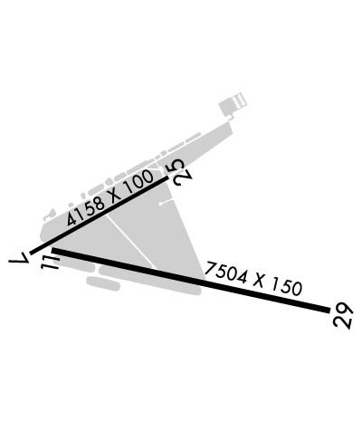
RWY 07/2 5 ACR NA.
RWY 11/2 9 STD GROOVING FULL LENGTH AND 130 FT WIDE CENTER PORTION.
Airport Communications & Frequencies:
ATIS Frequencies:   Hours(local) of Operation: CONTINUOUS
127.15
GAINESVILLE Tower Frequencies:   Hours(local) of operation: 0645-2230   
119.55
353.7
GAINESVILLE Ground Frequencies:
121.7
CTAF Frequency:
119.550
Unicom Frequency:
122.950
JACKSONVILLE Primary Approach Frequencies:  
118.175 10000 FT & BLW
338.25
JACKSONVILLE Primary Departure Frequencies:  
118.175 10000 FT & BLW
338.25
Runway Identifications
Runway Identification: 07/25
Length: 4158 ft
Width: 100 ft
Surface: ASPHALT-FAIR CONDITION
Edge lights: Medium Intensity

Treatment: GROOVED
Weight: PCN 43 /F/B/X/T

 Runway: 07   Runway: 25
Mag heading: 65°Mag heading: 245°
Rwy Slope: -.51% DownRwy Slope: .51% Up
Approach: Approach:
Pattern: Left TrafficPattern: Left Traffic
Markings: NONPRECISION INSTRUMENTMarkings: NONPRECISION INSTRUMENT
Marking Condition: GOODMarking Condition: GOOD
Arresting Dev: Arresting Dev:
Lat & Long: N2941.4  W08216.9Lat. & Long.: N2941.8  W08216.3
Elev: 151.4 ft. MSLElev: 130.2 ft. MSL
TCH: 44 ft. AGLTCH: 42 ft. AGL
Visual Glide Path: 3.00 degreesVisual Glide Path: 3.00 degrees
Displaced Threshold: NoDisplaced Threshold: No
Touchdown Zone: YESTouchdown Zone: YES
Touchdown Elev.: 151.4 feetTouchdown Elev.: 144.4 feet
Visual Glide Slope: 4-Light PAPI on LEFT side of RunwayVisual Glide Slope: 4-Light PAPI on LEFT side of Runway
RVR Equipment: RVR Equipment:
RVV Equipment: NORVV Equipment: NO
Approach Lights: Approach Lights:
REIL: NOREIL: NO
Centerline Lights: NOCenterline Lights: NO
Touchdown lights: NOTouchdown lights: NO
Runway Category: Runway with a Non-precision Approach having visibility minimums greater than 3/4 mileRunway Category: Runway with a Non-precision Approach having visibility minimums greater than 3/4 mile
Declared Distances: Declared Distances:
Obstructions: TREESObstructions: TREES
Marked: NOT Marked/LightedMarked: NOT Marked/Lighted
Clearance slope: 25:1Clearance slope: 34:1
Obstruction height: 70 feet AGLObstruction height: 34 feet AGL
Dist. from runway: 2006 feetDist. from runway: 1389 feet
Centerline offset: 432 left of centerlineCenterline offset: 423 feet left of centerline
Comments: Comments:
Runway Identification: 11/29
Length: 7504 ft
Width: 150 ft
Surface: ASPHALT-GOOD CONDITION
Edge lights: High Intensity

Treatment: GROOVED
Weight: PCN 56 /F/B/W/T

 Runway: 11   Runway: 29
Mag heading: 106°Mag heading: 286°
Rwy Slope: -.56% DownRwy Slope: .56% Up
Approach: Approach: ILS
Pattern: Left TrafficPattern: Left Traffic
Markings: PRECISION INSTRUMENTMarkings: PRECISION INSTRUMENT
Marking Condition: GOODMarking Condition: GOOD
Arresting Dev: Arresting Dev:
Lat & Long: N2941.4  W08216.8Lat. & Long.: N2941.2  W08215.5
Elev: 147.4 ft. MSLElev: 105.1 ft. MSL
TCH: 54 ft. AGLTCH: 55 ft. AGL
Visual Glide Path: 3.00 degreesVisual Glide Path: 3.00 degrees
Displaced Threshold: NoDisplaced Threshold: No
Touchdown Zone: YESTouchdown Zone: YES
Touchdown Elev.: 147.4 feetTouchdown Elev.: 122.4 feet
Visual Glide Slope: 4-Light PAPI on LEFT side of RunwayVisual Glide Slope: 4-Light PAPI on RIGHT side of Runway
RVR Equipment: ROLLOUTRVR Equipment: TOUCHDOWN
RVV Equipment: NORVV Equipment: NO
Approach Lights: Approach Lights: MALSR - 1,400 foot medium intensity approach lighting system with runway alignment indicator lights
REIL: YESREIL: NO
Centerline Lights: NOCenterline Lights: NO
Touchdown lights: NOTouchdown lights: NO
Runway Category: Runway with a Non-precision Approach having visibility minimums greater than 3/4 mileRunway Category: Precision Instrument Runway
Declared Distances: Declared Distances:
Obstructions: TREESObstructions: TREES
Marked: NOT Marked/LightedMarked: NOT Marked/Lighted
Clearance slope: 31:1Clearance slope: 49:1
Obstruction height: 81 feet AGLObstruction height: 68 feet AGL
Dist. from runway: 2783 feetDist. from runway: 3535 feet
Centerline offset: 626 right of centerlineCenterline offset: 458 feet left of centerline
Comments: Comments:
C:117/P: