KCRE

GRAND STRAND
NORTH MYRTLE BEACH
SC
Time Zone: Eastern
Lat: N 3348.7
Long: W 07843.4
Elev: 32
Var: +08
Longest Runway: 5997
Clr Del: 121.8
Dept. ATIS: 119.62
Arr. ATIS: 119.62
AWOS: 124.5
Ground: 121.8
Tower: 124.6

FBO & Flight Services info for KCRE

FBOs: Update your Fuel Prices

N. MYRTLE BCH AVPh: 843-848-7400 Fax: 843-272-5822 Freq: 122.95
Service
Jet
100LL
SAF
MoGas
Fuel Avail: 0700-2100 DAILY. FEE FOR AFTER HOURS; CONTACT FBO FOR CHARGES.
Full5.886.73    Last Update: 04/23/2024 09:07

Add .11 for JET A with Prist
Self  6.46    
 Address: PO BOX 1499, 29598 2800 TERMINAL ST   NORTH MYRTLE BEACH, SC 29582
ASOSPh: 843-361-2802
-
Freq: 124.5  
If you are an FBO, call 1-203-262-1700 to update your info or email: FltPlan.Advertising@garmin.com
Advertise your FBO on FltPlan.com

Runway & Approach Info for KCRE
Rwy
Length
Land Dist**
Approach*
  Rwy
Length
Land Dist**
Approach*
05
5997x100  5997'          
 
  
23
  5997x100  5997'          
ILS/DME
 111.70 - 234°  
 * only ILS, LOC, LDA, and SDF approaches to a specific runway are shown
** For any Declared Landing Distance Available, please see A/FD or Approach plates
Runway Weight Capability (lbs.) Help
Runway IDSingle WheelDouble WheelDouble Tandem WheelDual Double Wheel
05/2376,000112,000N/AN/A
These numbers are Advisory and are not limits.   The Airport Manager should have more accurate Weight Limits
Approach Charts
Approaches    
Current Weather/Notams
Customs Information Send updates to Support@FltPlan.com
Phone 843-241-3068
Fax 843-916-0442

Comments Mon-Fri 0800-1700 *2 hrs advance notice required weekdays. 4 hrs advance notice required weekends. *Maximum passengers per flight: 10 *Call prior to 1700 on preceding weekday. *Call prior to 1700 on preceding Friday for weekend service and Holidays.
Database effective 05/16/2024
Airport Diagram of KCRE
Airport Diagram might not be current.

Facility Name: GRAND STRAND
City Name: NORTH MYRTLE BEACH
County: HORRY
State abbrev: SC
State Name: SOUTH CAROLINA
   
Ownership: PUBLICLY OWNED
Use: OPEN TO THE PUBLIC
Owner's Name: HORRY COUNTY
Address: PO BOX 1236
 CONWAY, SC 29526
Owner's Phone: 843-448-1580
  
Manager's Name: JUDI OLMSTEAD
Address: 1100 JETPORT ROAD
 MYRTLE BEACH, SC 29577
Phone: 843-448-1580
   
FAA Region: SOUTHERN
FAA Field Office: ATL
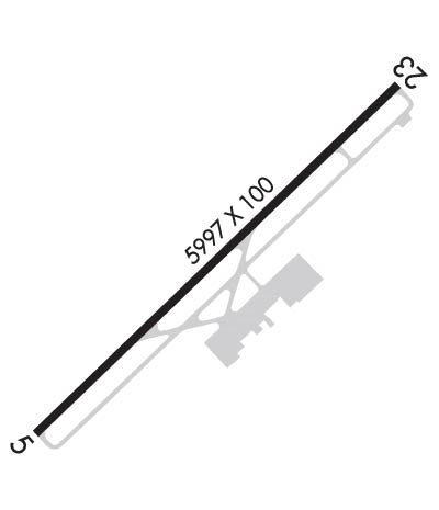

Sunrise / Sunset times for GRAND STRAND

DateSunriseSunset
04/25/24 Thursday6:3219:54
04/26/24 Friday6:3119:55
04/27/24 Saturday6:2919:56
04/28/24 Sunday6:2819:57
04/29/24 Monday6:2719:57
04/30/24 Tuesday6:2619:58
05/01/24 Wednesday6:2519:59
05/02/24 Thursday6:2420:00
05/03/24 Friday6:2320:01
05/04/24 Saturday6:2220:01
05/05/24 Sunday6:2120:02
05/06/24 Monday6:2120:03
05/07/24 Tuesday6:2020:04
05/08/24 Wednesday6:1920:04

Airport Facilities

Airport Attendance Schedule7 Days A Week 0700-2100
Airport Status OPERATIONAL (This Status can change at any time - please check NOTAMS)
Airport Lighting ScheduleAFTER 0000 ACTVT HIRL RY 05/23; REIL RY 05 AND MALSR RY 23 - CTAF.
Airport Storage AvailableTie Downs, Hanger
Extra Services AvailableCharter, Flight Instruction, Aircraft Rental
Wind IndicatorYES - (lighted)
Control TowerYES
CTAF Frequency124.600
Unicom Frequency122.950
Rotating Beacon ColorWG
Segmented CircleYES
Landing FeeNO

Airport Inspection Data

Airport InspectedSTATE - performed by STATE AERONAUTICAL PERSONNEL
Inspection Date09/20/2023

Airport Services

Type of Fuel AvailableGrade 100LL, JET A (freeze point -40C)
Airframe Repair ServiceNONE
Power Plant Repair ServiceNONE

Geographic Data

LatitudeN3348.7
LongitudeW07843.4 (ESTIMATED)
Arpt Elevation31ft (SURVEYED)
Magnetic Variation08W
1 miles NWof NORTH MYRTLE BEACH
Traffic Pattern Altitude
Sectional ChartCHARLOTTE

Aircraft Data

Operations (Reported)YearlyAvg. Daily
General Aviation Transient 1474040
General Aviation Local 1395938
Air Taxi 605317
Commerical 00
Commuter 00
Military 10203
Aircraft based on Field
General Aviation Singles 28
General Aviation Multi 5
Jet Aircraft 1
General Aviation Helicopters 1
Military Aircraft 0
Gliders 0
Ultralights 0

FAA Services

FSS on field NO
FSS tie-in ANDERSON
FSS Phone 1-800-WX-BRIEF
Who issues Notams CRE
Notam D service at airport YES
ARTCC Name JACKSONVILLE

Federal Status

Airport Certification
Aircraft Rescue & Firefighting IndexNone
Airport of EntryNo
Custom Landing RightsNo
Joint Civil/MilitaryNo
Military Landing rightsYES

Federal Agreements

NATIONAL PLAN OF INTEGRATED AIRPORT SYSTEMS (NPIAS)
GRANT AGREEMENTS UNDER FAAP/ADAP/AIP
ASSURANCES PURSUANT TO TITLE VI, CIVIL RIGHTS ACT OF 1964

Remarks

EXTENSIVE BANNER TOW OPERATIONS FM ARPT ALONG COAST LINE 10 NM NE TO 20 NM SW.
GULLS ON & INVOF ARPT.
FOR CD WHEN ATCT CLSD CTC MYRTLE BEACH APCH AT 843-477-2727/2704. WHEN MYR APCH CLSD CTC JACKSONVILLE ARTCC AT 904-845-1592.
Airport Communications & Frequencies:
ATIS Frequencies:   Hours(local) of Operation: CONTINUOUS
119.625
STRAND Tower Frequencies:   Hours(local) of operation: 0700-2100   
124.6
257.6
STRAND Ground Frequencies:
121.8
257.6
Clearance Delivery Frequencies:
121.8
CTAF Frequency:
124.600
Unicom Frequency:
122.950
Remarks
  • APCH/DEP SVC PRVDD BY JACKSONVILLE ARTCC ON FREQS 134.375/317.550 (MYRTLE BEACH RCAG) WHEN APCH CTL CLSD.
  • MYRTLE BEACH Primary Approach Frequencies:  
    119.2
    350.3
    MYRTLE BEACH Primary Departure Frequencies:  
    119.2
    350.3
    Runway Identifications
    Runway Identification: 05/23
    Length: 5997 ft
    Width: 100 ft
    Surface: ASPHALT-GOOD CONDITION
    Edge lights: High Intensity

    Treatment: NONE
    Weight: PCN 29 /F/B/X/T

     Runway: 05   Runway: 23
    Mag heading: 54°Mag heading: 234°
    Rwy Slope: -.04% DownRwy Slope: .04% Up
    Approach: Approach: ILS/DME
    Pattern: Left TrafficPattern: Right Traffic
    Markings: PRECISION INSTRUMENTMarkings: PRECISION INSTRUMENT
    Marking Condition: GOODMarking Condition: GOOD
    Arresting Dev: Arresting Dev:
    Lat & Long: N3348.4  W07843.9Lat. & Long.: N3349.0  W07843.0
    Elev: 31.6 ft. MSLElev: 29.2 ft. MSL
    TCH: 40 ft. AGLTCH: 55 ft. AGL
    Visual Glide Path: 3.00 degreesVisual Glide Path: 2.98 degrees
    Displaced Threshold: NoDisplaced Threshold: No
    Touchdown Zone: YESTouchdown Zone: YES
    Touchdown Elev.: 31.6 feetTouchdown Elev.: 29.6 feet
    Visual Glide Slope: 2-Light PAPI on LEFT side of RunwayVisual Glide Slope: 2-Light PAPI on RIGHT side of Runway
    RVR Equipment: RVR Equipment:
    RVV Equipment: NORVV Equipment: NO
    Approach Lights: Approach Lights: MALSR - 1,400 foot medium intensity approach lighting system with runway alignment indicator lights
    REIL: YESREIL: NO
    Centerline Lights: NOCenterline Lights: NO
    Touchdown lights: NOTouchdown lights: NO
    Runway Category: Runway with a Non-precision Approach having visibility minimums greater than 3/4 mileRunway Category: Precision Instrument Runway
    Declared Distances: Declared Distances:
    Obstructions: TREESObstructions: TREES
    Marked: NOT Marked/LightedMarked: NOT Marked/Lighted
    Clearance slope: 20:1Clearance slope: 33:1
    Obstruction height: 59 feet AGLObstruction height: 98 feet AGL
    Dist. from runway: 1434 feetDist. from runway: 3450 feet
    Centerline offset: 273 right of centerlineCenterline offset: 672 feet left of centerline
    Comments: Comments:
    C:40/P: