KCLL

EASTERWOOD FIELD
COLLEGE STATION
TX
Time Zone: Central
Lat: N 3035.3
Long: W 09621.8
Elev: 321
Var: -03
Longest Runway: 7000
Clr Del: 120.4 TWR CLD
Dept. ATIS: 126.85
Arr. ATIS: 126.85
AWOS: 126.85
Ground: 128.7
Tower: 118.5

FBO & Flight Services info for KCLL

FBOs: Update your Fuel Prices

ASTIN AVIATIONPh: 979-775-5255 Fax: 979-775-9912 Freq: 122.95
Service
Jet
100LL
SAF
MoGas
Fuel Avail: PRIST + $0.10/gal. After hours fee of $100.00/HR
Full6.397.21    Last Update: 04/09/2024 10:52

Self        
 Address: 1 MCKENZIE TERMINAL BLVD   COLLEGE STATION, TX 77845
ASOSPh: 979-846-1708
-
-
 
If you are an FBO, call 1-203-262-1700 to update your info or email: FltPlan.Advertising@garmin.com
Advertise your FBO on FltPlan.com

Runway & Approach Info for KCLL
Rwy
Length
Land Dist**
Approach*
  Rwy
Length
Land Dist**
Approach*
11
5158x150  5158'          
 
  
29
  5158x150  5158'          
 
17
7000x146  7000'          
 
  
35
  7000x146  7000'          
ILS/DME
 110.55 - 345°  
 * only ILS, LOC, LDA, and SDF approaches to a specific runway are shown
** For any Declared Landing Distance Available, please see A/FD or Approach plates
Runway Weight Capability (lbs.) Help
Runway IDSingle WheelDouble WheelDouble Tandem WheelDual Double Wheel
11/2937,00049,000N/AN/A
17/3578,00094,000156,000N/A
These numbers are Advisory and are not limits.   The Airport Manager should have more accurate Weight Limits
Approach Charts
Approaches    
Current Weather/Notams
Customs Information Send updates to Support@FltPlan.com
Customs Not Available
Database effective 05/16/2024
Airport Diagram of KCLL
Airport Diagram might not be current.

Facility Name: EASTERWOOD FLD
City Name: COLLEGE STATION
County: BRAZOS
State abbrev: TX
State Name: TEXAS
   
Ownership: PUBLICLY OWNED
Use: OPEN TO THE PUBLIC
Owner's Name: TEXAS A&M UNIVERSITY SYSTEM
Address: 301 TARROW STREET
 COLLEGE STATION, TX 77840
Owner's Phone: (979) 775-9900
  
Manager's Name: KEVIN DAVIS
Address: 1 MCKENZIE TERMINAL BLVD, SUITE 112
 COLLEGE STATION, TX 77845
Phone: 979-775-9901
   
FAA Region: SOUTHWEST
FAA Field Office: TEX


Sunrise / Sunset times for EASTERWOOD FLD

DateSunriseSunset
04/25/24 Thursday6:4720:00
04/26/24 Friday6:4620:01
04/27/24 Saturday6:4520:02
04/28/24 Sunday6:4420:02
04/29/24 Monday6:4320:03
04/30/24 Tuesday6:4220:04
05/01/24 Wednesday6:4120:04
05/02/24 Thursday6:4020:05
05/03/24 Friday6:3920:06
05/04/24 Saturday6:3820:06
05/05/24 Sunday6:3820:07
05/06/24 Monday6:3720:08
05/07/24 Tuesday6:3620:08
05/08/24 Wednesday6:3520:09

Airport Facilities

Airport Attendance Schedule7 Days A Week 0600-2200
Airport Status OPERATIONAL (This Status can change at any time - please check NOTAMS)
Airport Lighting ScheduleWHEN ATCT CLSD ACTVT MALSR RWY 35; MIRL RWY 11/29; HIRL RWY 17/35 - CTAF. REIL RWY 29 PRESET LOW INTST ONLY.
Airport Storage AvailableTie Downs, Hanger
Extra Services AvailableAvionics, Charter, Flight Instruction
Wind IndicatorYES - (lighted)
Control TowerYES
CTAF Frequency118.500
Unicom Frequency122.950
Rotating Beacon ColorWG
Segmented CircleYES
Landing FeeNO

Airport Inspection Data

Airport InspectedFEDERAL - performed by FAA AIRPORTS FIELD PERSONNEL
Inspection Date12/07/2023

Airport Services

Type of Fuel AvailableGrade 100LL, JET A (freeze point -40C), JET A; -10FUEL SVC 0600-2200. FOR FUEL AFT HRS PPR CALL 979-775-5255. LATE NIGHT FEE.
Airframe Repair ServiceMAJOR
Power Plant Repair ServiceMAJOR

Geographic Data

LatitudeN3035.3
LongitudeW09621.8 (ESTIMATED)
Arpt Elevation320ft (SURVEYED)
Magnetic Variation03E
3 miles SWof COLLEGE STATION
Traffic Pattern Altitude
Sectional ChartHOUSTON

Aircraft Data

Operations (Reported)YearlyAvg. Daily
General Aviation Transient 3243589
General Aviation Local 1422539
Air Taxi 556715
Commerical 14194
Commuter 00
Military 1077230
Aircraft based on Field
General Aviation Singles 23
General Aviation Multi 10
Jet Aircraft 7
General Aviation Helicopters 1
Military Aircraft 0
Gliders 0
Ultralights 0

FAA Services

FSS on field NO
FSS tie-in MONTGOMERY COUNTY
FSS Phone 1-800-WX-BRIEF
Who issues Notams CLL
Notam D service at airport YES
ARTCC Name HOUSTON

Federal Status

Airport CertificationAIRPORT RECEIVING SCHEDULED AIR CARRIER SERVICE FROM CARRIERS CERTIFICATED BY THE CIVIL AERONAUTICS BOARD; CLSD TO UNSKED ACR OPNS WITH MORE THAN 30 PSGR SEATS EXCP 24 HRS PPR CALL AMGR 979-775-9920.
Aircraft Rescue & Firefighting IndexAIRPORT HAS A CERTIFICATE UNDER CFR PART 139
Airport of EntryNo
Custom Landing RightsNo
Joint Civil/MilitaryNo
Military Landing rightsYES

Federal Agreements

NATIONAL PLAN OF INTEGRATED AIRPORT SYSTEMS (NPIAS)
GRANT AGREEMENTS UNDER FAAP/ADAP/AIP
ASSURANCES PURSUANT TO TITLE VI, CIVIL RIGHTS ACT OF 1964
AGREEMENT UNDER DLAND OR DCLA HAS EXPIRED.

Remarks

ALL RAPID RFL MIL HEL ADZ ATC FOR RAPID RFL OPS & PROCD TO SOUTH RAMP. CTC ASTIN AVN UNICOM 122.95 FOR SVC PRIOR TO LNDG. RAPID RFL IS AVBL 0600-2200 DLY. SPL RQS CSDRD ON CASE BY CASE BASIS.
FOR CD IF UNA TO CTC ON FSS FREQ, CTC HOUSTON ARTCC AT 281-230-5622.
ALL ACFT PRKG ON SE RAMP MUST CTC ASTIN AVN FOR SVC OR TRNSP, UNICOM 122.95 OR 979-775-5255.
TURN FEE SKEDD FAR 135 AND ALL FAR 121 OPNS.
PAEW ADJ ALL RWYS AND TWYS 0600-1600.
SFC COND NOT RPRTD FM 1700-0500 LCA MON-FRI AND SAT-SUN.
(CONTACT PHONE NR) CABBOTT@EASTERWOODAIRPORT.COM
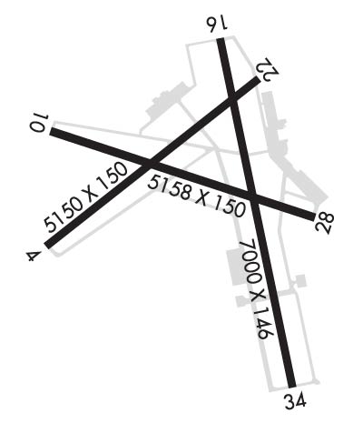
RWY 17/3 5 FIRST 1850 FT RWY 35 CONC.
Airport Communications & Frequencies:
ATIS Frequencies:   Hours(local) of Operation: CONTINUOUS
126.85
EASTERWOOD Tower Frequencies:   Hours(local) of operation: 0800-2100   
118.5
284.7
EASTERWOOD Ground Frequencies:
128.7
284.7
Clearance Delivery Frequencies:
128.7
120.4 WHEN TWR CLSD
Emergency Frequencies:
121.5
243.0
CTAF Frequency:
118.500
Unicom Frequency:
122.950
HOUSTON Primary Approach Frequencies:  
134.3
360.85
HOUSTON Primary Departure Frequencies:  
134.3
360.85
Runway Identifications
Runway Identification: 11/29
Length: 5158 ft
Width: 150 ft
Surface: ASPHALT
Edge lights: Medium Intensity

Treatment: GROOVED
Weight: PCN 14 /F/D/X/T

 Runway: 11   Runway: 29
Mag heading: 106°Mag heading: 286°
Rwy Slope: -.16% DownRwy Slope: .16% Up
Approach: Approach:
Pattern: Left TrafficPattern: Left Traffic
Markings: NONPRECISION INSTRUMENTMarkings: NONPRECISION INSTRUMENT
Marking Condition: GOODMarking Condition: GOOD
Arresting Dev: Arresting Dev:
Lat & Long: N3035.5  W09622.4Lat. & Long.: N3035.2  W09621.4
Elev: 319.4 ft. MSLElev: 311.4 ft. MSL
TCH: 50 ft. AGLTCH: 54 ft. AGL
Visual Glide Path: 3.00 degreesVisual Glide Path: 3.00 degrees
Displaced Threshold: NoDisplaced Threshold: No
Touchdown Zone: YESTouchdown Zone: YES
Touchdown Elev.: 319.4 feetTouchdown Elev.: 313.9 feet
Visual Glide Slope: 4-BOX VASI ON LEFT SIDE OF RUNWAYVisual Glide Slope: 4-BOX VASI ON LEFT SIDE OF RUNWAY
RVR Equipment: RVR Equipment:
RVV Equipment: NORVV Equipment: NO
Approach Lights: Approach Lights:
REIL: NOREIL: YES
Centerline Lights: NOCenterline Lights: NO
Touchdown lights: NOTouchdown lights: NO
Runway Category: Runway with a Non-precision Approach having visibility minimums greater than 3/4 mileRunway Category: Runway with a Non-precision Approach having visibility minimums greater than 3/4 mile
Declared Distances: TORA:5158' TODA:5158' ASDA:5158' LDA:5158'Declared Distances: TORA:5158' TODA:5158' ASDA:5158' LDA:5158'
Obstructions: TREEObstructions: TREE
Marked: NOT Marked/LightedMarked: NOT Marked/Lighted
Clearance slope: 24:1Clearance slope: 17:1
Obstruction height: 40 feet AGLObstruction height: 18 feet AGL
Dist. from runway: 1180 feetDist. from runway: 500 feet
Centerline offset: 400 right of centerlineCenterline offset: 230 feet left of centerline
Comments: Comments:
Runway Identification: 17/35
Length: 7000 ft
Width: 146 ft
Surface: CONCRETE ASPHALT
Edge lights: High Intensity

Treatment: GROOVED
Weight: PCN 29 /R/D/X/T

 Runway: 17   Runway: 35
Mag heading: 166°Mag heading: 346°
Rwy Slope: -.23% DownRwy Slope: .23% Up
Approach: Approach: ILS/DME
Pattern: Left TrafficPattern: Left Traffic
Markings: PRECISION INSTRUMENTMarkings: PRECISION INSTRUMENT
Marking Condition: GOODMarking Condition: GOOD
Arresting Dev: Arresting Dev:
Lat & Long: N3035.8  W09621.8Lat. & Long.: N3034.7  W09621.5
Elev: 320.6 ft. MSLElev: 304.3 ft. MSL
TCH: 51 ft. AGLTCH:
Visual Glide Path: 3.00 degreesVisual Glide Path:
Displaced Threshold: NoDisplaced Threshold: No
Touchdown Zone: YESTouchdown Zone: YES
Touchdown Elev.: 320.6 feetTouchdown Elev.: 310.6 feet
Visual Glide Slope: 4-BOX VASI ON RIGHT SIDE OF RUNWAYVisual Glide Slope:
RVR Equipment: RVR Equipment:
RVV Equipment: NORVV Equipment: NO
Approach Lights: Approach Lights: MALSR - 1,400 foot medium intensity approach lighting system with runway alignment indicator lights
REIL: NOREIL: NO
Centerline Lights: NOCenterline Lights: NO
Touchdown lights: NOTouchdown lights: NO
Runway Category: Runway with a Non-precision Approach having visibility minimums greater than 3/4 mileRunway Category: Precision Instrument Runway
Declared Distances: TORA:7000' TODA:7000' ASDA:7000' LDA:7000'Declared Distances: TORA:7000' TODA:7000' ASDA:6932' LDA:6932'
Obstructions: TREEObstructions:
Marked: NOT Marked/LightedMarked:
Clearance slope: 7:1Clearance slope: 50:1
Obstruction height: 42 feet AGLObstruction height:
Dist. from runway: 500 feetDist. from runway:
Centerline offset: 480 right of centerlineCenterline offset:
Comments: Comments:
C:67/P: