Current Weather/Notams (Metars, TAFs, Notams, NWS Forecast, PIREPS, and nearby weather)
Customs Information Send updates to Support@FltPlan.com
Customs Not Available
Database effective 05/16/2024
Airport Diagram might not be current. Facility Name: BOWLING GREEN-WARREN COUNTY RGNL City Name: BOWLING GREEN County: WARREN State abbrev: KY State Name: KENTUCKY Ownership: PUBLICLY OWNED Use: OPEN TO THE PUBLIC Owner's Name: CITY BOWLING GREEN-WARREN CO Address: 1000 WOODHURST ST BOWLING GREEN, KY 42103 Owner's Phone: 270-842-1101 Manager's Name: SUSAN HARMON Address: 1000 WOODHURST ST BOWLING GREEN, KY 42103 Phone: 270-842-1101 FAA Region: SOUTHERN FAA Field Office: MEM
Runway Identifications Help
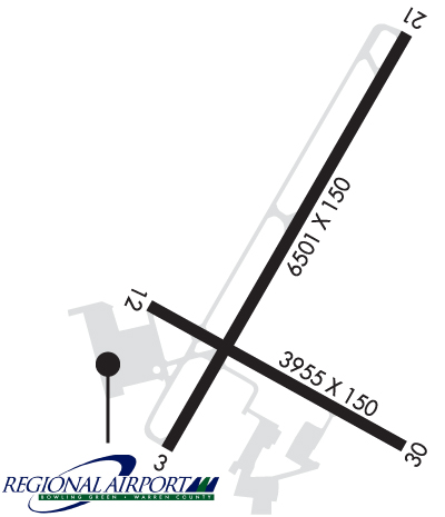
Runway Identification: 03/21 Length: 6501 ftWidth: 150 ftSurface: ASPHALT-GOOD CONDITIONEdge lights: High Intensity Treatment: NONEWeight: PCN 63 /F/C/X/T Runway: 03 Runway: 21 Mag heading: 34° Mag heading: 214° Rwy Slope: -.41% Down Rwy Slope: .41% Up Approach: ILS Approach: Pattern: Left Traffic Pattern: Left Traffic Markings: PRECISION INSTRUMENT Markings: NONPRECISION INSTRUMENT Marking Condition: GOOD Marking Condition: GOOD Arresting Dev: Arresting Dev: Lat & Long: N3657.5 W08625.5 Lat. & Long.: N3658.4 W08624.8 Elev: 547.1 ft. MSL Elev: 520.4 ft. MSL TCH: 44 ft. AGL TCH: 30 ft. AGL Visual Glide Path: 3.00 degrees Visual Glide Path: 3.00 degrees Displaced Threshold: No Displaced Threshold: No Touchdown Zone: YES Touchdown Zone: YES Touchdown Elev.: 547.2 feet Touchdown Elev.: 522.4 feet Visual Glide Slope: 4-Light PAPI on LEFT side of Runway Visual Glide Slope: 4-Light PAPI on LEFT side of Runway RVR Equipment: RVR Equipment: RVV Equipment: NO RVV Equipment: NO Approach Lights: Approach Lights: REIL: YES REIL: YES Centerline Lights: NO Centerline Lights: NO Touchdown lights: NO Touchdown lights: NO Runway Category: Precision Instrument Runway Runway Category: Runway with a Non-precision Approach having visibility minimums greater than 3/4 mile Declared Distances: TORA:6500' TODA:6500' ASDA:6500' LDA:6500' Declared Distances: TORA:6500' TODA:6500' ASDA:6500' LDA:6500'
Runway Identification: 12/30 Length: 3956 ftWidth: 150 ftSurface: ASPHALT-POOR CONDITIONEdge lights: Medium Intensity Treatment: NONEWeight: PCN 9 /F/C/X/T Runway: 12 Runway: 30 Mag heading: 124° Mag heading: 304° Rwy Slope: .01% Up Rwy Slope: -.01% Down Approach: Approach: Pattern: Left Traffic Pattern: Left Traffic Markings: BASIC Markings: BASIC Marking Condition: GOOD Marking Condition: GOOD Arresting Dev: Arresting Dev: Lat & Long: N3657.8 W08625.6 Lat. & Long.: N3657.5 W08624.8 Elev: 530.9 ft. MSL Elev: 531.2 ft. MSL TCH: TCH: Visual Glide Path: Visual Glide Path: Displaced Threshold: No Displaced Threshold: 349 feet Touchdown Zone: YES Touchdown Zone: YES Touchdown Elev.: 530.9 feet Touchdown Elev.: 529.1 feet Visual Glide Slope: Visual Glide Slope: RVR Equipment: RVR Equipment: RVV Equipment: NO RVV Equipment: NO Approach Lights: Approach Lights: REIL: NO REIL: NO Centerline Lights: NO Centerline Lights: NO Touchdown lights: NO Touchdown lights: NO Runway Category: Runway with a Visual Approach Runway Category: Runway with a Visual Approach Declared Distances: Declared Distances: