
| NORTH LAS VEGAS LAS VEGAS NV |
| |
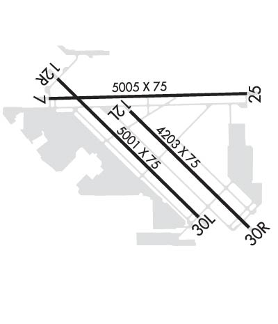
| Lat: N 3612.6 Long: W 11511.7 Elev: 2205 Var: -14 Longest Runway: 5005 | ||
| Clr Del: 124.0 Dept. ATIS: 118.05 Arr. ATIS: 118.05 AWOS: 118.05 Ground: 121.7 Tower: 125.7 | ||
| ||||||||||||||||||||||||||||||||||||||||||||||||||||||||||||||||||||
| ||||||||||||||||||||||||||||||||||||||||||||||||||||||||||||||||||||
| ||||||||||||||||||||||||||||||||||||||||||||||||||||||||||||||||||||
| ||||||||||||||||||||||||||||||||||||||||||||||||||||||||||||||||||||
| ||||||||||||||||||||||||||||||||||||||||||||||||||||||||||||||||||||
| Rwy | Rwy | |||||||
| 5005x75 | 5005' | 5005x75 | 5005' | |||||
| 4199x75 | 4199' | 110.70 - 120° | 4199x75 | 4000' | ||||
| 5000x75 | 5000' | 5000x75 | 5000' | |||||
| Runway ID | Single Wheel | Double Wheel | Double Tandem Wheel | Dual Double Wheel |
| 07/25 | 30,000 | N/A | N/A | N/A |
| 12L/30R | 30,000 | N/A | N/A | N/A |
| 12R/30L | 30,000 | N/A | N/A | N/A |
| These numbers are Advisory and are not limits. The Airport Manager should have more accurate Weight Limits | ||||
 Airport Diagram might not be current. | |
| Facility Name: | NORTH LAS VEGAS |
| City Name: | LAS VEGAS |
| County: | CLARK |
| State abbrev: | NV |
| State Name: | NEVADA |
| Ownership: | PUBLICLY OWNED |
| Use: | OPEN TO THE PUBLIC |
| Owner's Name: | CLARK COUNTY |
| Address: | 2730 AIRPORT DR SUITE 101 |
| NORTH LAS VEGAS, NV 89032 | |
| Owner's Phone: | 702-261-3803 |
| Manager's Name: | KARINA TARNOWSKA; MGR. ALSO 702-261-3802. 702.261.3804, NORTH LAS VEGAS AIRPORT 2730 AIRPORT DRIVE, SUITE 101 NORTH LAS VEGAS, NV 89032 |
| Address: | 2730 AIRPORT DR SUITE 101 |
| NORTH LAS VEGAS, NV 89032 | |
| Phone: | 702-261-3804 |
| FAA Region: | WESTERN-PACIFIC |
| FAA Field Office: | PHX |

| Date | Sunrise | Sunset |
|---|---|---|
| 05/12/25 Monday | 5:37 | 19:38 |
| 05/13/25 Tuesday | 5:36 | 19:38 |
| 05/14/25 Wednesday | 5:35 | 19:39 |
| 05/15/25 Thursday | 5:35 | 19:40 |
| 05/16/25 Friday | 5:34 | 19:41 |
| 05/17/25 Saturday | 5:33 | 19:42 |
| 05/18/25 Sunday | 5:32 | 19:42 |
| 05/19/25 Monday | 5:32 | 19:43 |
| 05/20/25 Tuesday | 5:31 | 19:44 |
| 05/21/25 Wednesday | 5:30 | 19:45 |
| 05/22/25 Thursday | 5:30 | 19:46 |
| 05/23/25 Friday | 5:29 | 19:46 |
| 05/24/25 Saturday | 5:28 | 19:47 |
| 05/25/25 Sunday | 5:28 | 19:48 |
| Airport Attendance Schedule | 7 Days A Week 0500-2230 |
| Airport Status | OPERATIONAL (This Status can change at any time - please check NOTAMS) |
| Airport Lighting Schedule | WHEN ATCT CLSD ACTVT REIL RWY 07 & 25, 12L & 30R, 12R & 30L; PAPI RWY 07 & 25, 12L & 30R, 12R & 30L; MIRL RWY 07/25, 12L/30R, 12R/30L; TWY LGTS - CTAF. |
| Airport Storage Available | Tie Downs |
| Extra Services Available | Air Ambulance, Avionics, Cargo Handling, Charter, Flight Instruction, Aircraft Rental, Aircraft Sales |
| Wind Indicator | YES - (lighted) |
| Control Tower | YES |
| CTAF Frequency | 125.700 |
| Unicom Frequency | 122.950 |
| Rotating Beacon Color | WG |
| Segmented Circle | YES |
| Landing Fee | NO |
| Airport Inspected | STATE - performed by STATE AERONAUTICAL PERSONNEL |
| Inspection Date | 07/05/2022 |
| Type of Fuel Available | Grade 100LL, JET A (freeze point -40C) |
| Airframe Repair Service | MAJOR |
| Power Plant Repair Service | MAJOR |
| Latitude | N3612.6 |
| Longitude | W11511.7 (ESTIMATED) |
| Arpt Elevation | 2205ft (SURVEYED) |
| Magnetic Variation | 14E |
| 3 miles NW | of LAS VEGAS |
| Traffic Pattern Altitude | 800 |
| Sectional Chart | LAS VEGAS |
| Operations (Reported) | Yearly | Avg. Daily |
|---|---|---|
| General Aviation Transient | 0 | 0 |
| General Aviation Local | 0 | 0 |
| Air Taxi | 0 | 0 |
| Commerical | 0 | 0 |
| Commuter | 0 | 0 |
| Military | 0 | 0 |
| Aircraft based on Field | |
|---|---|
| General Aviation Singles | 0 |
| General Aviation Multi | 0 |
| Jet Aircraft | 0 |
| General Aviation Helicopters | 0 |
| Military Aircraft | 0 |
| Gliders | 0 |
| Ultralights | 0 |
| FSS on field | NO |
| FSS tie-in | RENO |
| FSS Phone | 1-800-WX-BRIEF |
| Who issues Notams | VGT |
| Notam D service at airport | YES |
| ARTCC Name | LOS ANGELES |
| Airport Certification | ARFF INDEX A, 139.315 (E) |
| Aircraft Rescue & Firefighting Index | None |
| Airport of Entry | No |
| Custom Landing Rights | No |
| Joint Civil/Military | No |
| Military Landing rights | No |
| NATIONAL PLAN OF INTEGRATED AIRPORT SYSTEMS (NPIAS) |
| GRANT AGREEMENTS UNDER FAAP/ADAP/AIP |
| ASSURANCES PURSUANT TO TITLE VI, CIVIL RIGHTS ACT OF 1964 |
| AIMING POINT MKD AT 1000 FT - ALL RWYS. |
| RWY GUARD LGTS AT ALL INTXNS. |
| FOR CD WHEN ATCT IS CLSD CTC LAS APCH ON 124.0 OR PH 725-200-4432. |
| WHEN SPL EVENT PRKG PPR PROGRAM NOTAM IS ACTV, TSNT ACFT OPERS NOT PERM BASED NEED TO OBTAIN A PPR NR FM AN FBO FOR EA LDG. PPR APPVL & CONFIRMATION NRS CAN BE OBTAINED FM THE SEL FBO AT 702-261-7775. PPR CONFIRMATION NRS SHOULD BE ENTERED IN THE |
| RWY 12R CALM WIND RWY. |
Airport Communications & Frequencies:
| |||||||||||||||||||||||||||||||||
| Runway: 07 | Runway: 25 | ||
| Mag heading: | 74° | Mag heading: | 254° |
| Rwy Slope: | -.63% Down | Rwy Slope: | .63% Up |
| Approach: | Approach: | ||
| Pattern: | Left Traffic | Pattern: | Left Traffic |
| Markings: | BASIC | Markings: | BASIC |
| Marking Condition: | GOOD | Marking Condition: | GOOD |
| Arresting Dev: | Arresting Dev: | ||
| Lat & Long: | N3612.8 W11512.2 | Lat. & Long.: | N3612.8 W11511.2 |
| Elev: | 2204.2 ft. MSL | Elev: | 2172.5 ft. MSL |
| TCH: | 37 ft. AGL | TCH: | 36 ft. AGL |
| Visual Glide Path: | 3.00 degrees | Visual Glide Path: | 3.00 degrees |
| Displaced Threshold: | No | Displaced Threshold: | No |
| Touchdown Zone: | YES | Touchdown Zone: | YES |
| Touchdown Elev.: | 2204.2 feet | Touchdown Elev.: | 2189.6 feet |
| Visual Glide Slope: | 4-Light PAPI on LEFT side of Runway | Visual Glide Slope: | 4-Light PAPI on LEFT side of Runway |
| RVR Equipment: | RVR Equipment: | ||
| RVV Equipment: | NO | RVV Equipment: | NO |
| Approach Lights: | Approach Lights: | ||
| REIL: | YES | REIL: | YES |
| Centerline Lights: | NO | Centerline Lights: | NO |
| Touchdown lights: | NO | Touchdown lights: | NO |
| Runway Category: | Runway with a Visual Approach | Runway Category: | Runway with a Visual Approach |
| Declared Distances: | TORA:5005' TODA:5005' ASDA:5005' LDA:5005' | Declared Distances: | TORA:5005' TODA:5005' ASDA:5005' LDA:5005' |
| Obstructions: | POLE | Obstructions: | |
| Marked: | NOT Marked/Lighted | Marked: | |
| Clearance slope: | 24:1 | Clearance slope: | 50:1 |
| Obstruction height: | 50 feet AGL | Obstruction height: | |
| Dist. from runway: | 1434 feet | Dist. from runway: | |
| Centerline offset: | Centerline offset: | ||
| Comments: | Comments: |
| Runway: 12L | Runway: 30R | ||
| Mag heading: | 120° | Mag heading: | 300° |
| Rwy Slope: | -1.04% Down | Rwy Slope: | 1.04% Up |
| Approach: | ILS/DME | Approach: | |
| Pattern: | Left Traffic | Pattern: | Left Traffic |
| Markings: | PRECISION INSTRUMENT | Markings: | BASIC |
| Marking Condition: | GOOD | Marking Condition: | GOOD |
| Arresting Dev: | Arresting Dev: | ||
| Lat & Long: | N3612.7 W11511.8 | Lat. & Long.: | N3612.3 W11511.2 |
| Elev: | 2188.6 ft. MSL | Elev: | 2145.1 ft. MSL |
| TCH: | 48 ft. AGL | TCH: | 40 ft. AGL |
| Visual Glide Path: | 3.20 degrees | Visual Glide Path: | 3.00 degrees |
| Displaced Threshold: | No | Displaced Threshold: | 199 feet |
| Touchdown Zone: | YES | Touchdown Zone: | YES |
| Touchdown Elev.: | 2188.6 feet | Touchdown Elev.: | 2181.0 feet |
| Visual Glide Slope: | 4-Light PAPI on LEFT side of Runway | Visual Glide Slope: | 4-Light PAPI on LEFT side of Runway |
| RVR Equipment: | RVR Equipment: | ||
| RVV Equipment: | NO | RVV Equipment: | NO |
| Approach Lights: | Approach Lights: | ||
| REIL: | YES | REIL: | YES |
| Centerline Lights: | NO | Centerline Lights: | NO |
| Touchdown lights: | NO | Touchdown lights: | NO |
| Runway Category: | Precision Instrument Runway | Runway Category: | Runway with a Visual Approach |
| Declared Distances: | TORA:4199' TODA:4199' ASDA:4199' LDA:4199' | Declared Distances: | TORA:4199' TODA:4199' ASDA:4199' LDA:4000' |
| Obstructions: | BLDG | Obstructions: | Unknown |
| Marked: | NOT Marked/Lighted | Marked: | NOT Marked/Lighted |
| Clearance slope: | 45:1 | Clearance slope: | 25:1 |
| Obstruction height: | 45 feet AGL | Obstruction height: | 60 feet AGL |
| Dist. from runway: | 2019 feet | Dist. from runway: | 1511 feet |
| Centerline offset: | Centerline offset: | ||
| Comments: | Comments: |
| Runway: 12R | Runway: 30L | ||
| Mag heading: | 120° | Mag heading: | 300° |
| Rwy Slope: | -.84% Down | Rwy Slope: | .84% Up |
| Approach: | Approach: | ||
| Pattern: | Left Traffic | Pattern: | Left Traffic |
| Markings: | NONPRECISION INSTRUMENT | Markings: | NONPRECISION INSTRUMENT |
| Marking Condition: | GOOD | Marking Condition: | GOOD |
| Arresting Dev: | Arresting Dev: | ||
| Lat & Long: | N3612.9 W11512.2 | Lat. & Long.: | N3612.3 W11511.4 |
| Elev: | 2205.0 ft. MSL | Elev: | 2163.0 ft. MSL |
| TCH: | 25 ft. AGL | TCH: | 40 ft. AGL |
| Visual Glide Path: | 3.00 degrees | Visual Glide Path: | 3.00 degrees |
| Displaced Threshold: | No | Displaced Threshold: | No |
| Touchdown Zone: | YES | Touchdown Zone: | YES |
| Touchdown Elev.: | 2205.0 feet | Touchdown Elev.: | 2191.2 feet |
| Visual Glide Slope: | 4-Light PAPI on LEFT side of Runway | Visual Glide Slope: | 4-Light PAPI on LEFT side of Runway |
| RVR Equipment: | RVR Equipment: | ||
| RVV Equipment: | NO | RVV Equipment: | NO |
| Approach Lights: | Approach Lights: | ||
| REIL: | YES | REIL: | YES |
| Centerline Lights: | NO | Centerline Lights: | NO |
| Touchdown lights: | NO | Touchdown lights: | NO |
| Runway Category: | Runway with a Non-precision Approach having visibility minimums greater than 3/4 mile | Runway Category: | Runway with a Non-precision Approach having visibility minimums greater than 3/4 mile |
| Declared Distances: | TORA:5000' TODA:5000' ASDA:5000' LDA:5000' | Declared Distances: | TORA:5000' TODA:5000' ASDA:5000' LDA:5000' |
| Obstructions: | BLDG | Obstructions: | Unknown |
| Marked: | NOT Marked/Lighted | Marked: | NOT Marked/Lighted |
| Clearance slope: | 28:1 | Clearance slope: | 26:1 |
| Obstruction height: | 45 feet AGL | Obstruction height: | 32 feet AGL |
| Dist. from runway: | 1500 feet | Dist. from runway: | 1050 feet |
| Centerline offset: | Centerline offset: | ||
| Comments: | Comments: |
Thanks for using FltPlan.com
all rights reserved © 1999-2025 by Flight Plan LLC


