
| FRIEDMAN MEMORIAL HAILEY ID |
| |
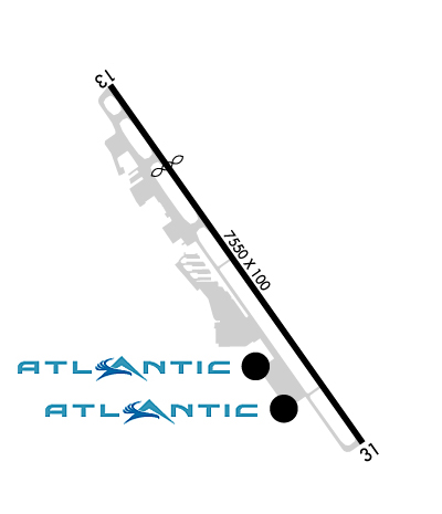
| Lat: N 4330.2 Long: W 11417.7 Elev: 5320 Var: -13 Longest Runway: 7550 | ||
| Dept. ATIS: 128.22 Arr. ATIS: 128.22 AWOS: 128.22 Ground: 121.7 Tower: 125.6 | ||
| |||||||||||||||||||||||||||||||||||||||||||||||||||||||||||||||||||||
| |||||||||||||||||||||||||||||||||||||||||||||||||||||||||||||||||||||
| |||||||||||||||||||||||||||||||||||||||||||||||||||||||||||||||||||||
| Rwy | Rwy | |||||||
| 7550x100 | 5849' | 7550x100 | 7550' | |||||
| Runway ID | Single Wheel | Double Wheel | Double Tandem Wheel | Dual Double Wheel |
| 13/31 | 65,000 | 95,000 | 150,000 | N/A |
| These numbers are Advisory and are not limits. The Airport Manager should have more accurate Weight Limits | ||||
 Airport Diagram might not be current. | |
| Facility Name: | FRIEDMAN MEML |
| City Name: | HAILEY |
| County: | BLAINE |
| State abbrev: | ID |
| State Name: | IDAHO |
| Ownership: | PUBLICLY OWNED |
| Use: | OPEN TO THE PUBLIC |
| Owner's Name: | CITY OF HAILEY |
| Address: | BLANE CO - BOX 400 |
| HAILEY, ID 83333 | |
| Owner's Phone: | 208-788-4221; 208-788-5500. |
| Manager's Name: | TIM BURKE |
| Address: | 1616 AIRPORT CIR |
| HAILEY, ID 83333-5534 | |
| Phone: | 208-720-5186 |
| FAA Region: | NORTHWEST MOUNTAIN |
| FAA Field Office: | HLN |

| Date | Sunrise | Sunset |
|---|---|---|
| 04/28/25 Monday | 6:34 | 20:36 |
| 04/29/25 Tuesday | 6:33 | 20:37 |
| 04/30/25 Wednesday | 6:32 | 20:38 |
| 05/01/25 Thursday | 6:30 | 20:39 |
| 05/02/25 Friday | 6:29 | 20:40 |
| 05/03/25 Saturday | 6:27 | 20:41 |
| 05/04/25 Sunday | 6:26 | 20:43 |
| 05/05/25 Monday | 6:25 | 20:44 |
| 05/06/25 Tuesday | 6:23 | 20:45 |
| 05/07/25 Wednesday | 6:22 | 20:46 |
| 05/08/25 Thursday | 6:21 | 20:47 |
| 05/09/25 Friday | 6:20 | 20:48 |
| 05/10/25 Saturday | 6:18 | 20:49 |
| 05/11/25 Sunday | 6:17 | 20:51 |
| Airport Attendance Schedule | 7 Days A Week 0700-2300 |
| Airport Status | OPERATIONAL (This Status can change at any time - please check NOTAMS) |
| Airport Lighting Schedule | WHEN ATCT CLSD ACTVT HIRL RWY 13/31 - CTAF. PAPI RWY 31 OPR CONSLY. |
| Airport Storage Available | Tie Downs, Hanger |
| Extra Services Available | Air Freight, Air Ambulance, Cargo Handling, Charter, Flight Instruction, Aircraft Rental, Aircraft Sales |
| Wind Indicator | YES - (lighted) |
| Control Tower | YES |
| CTAF Frequency | 125.600 |
| Unicom Frequency | 122.950 |
| Rotating Beacon Color | WG |
| Segmented Circle | NO |
| Landing Fee | YES; LNDG FEE GTR THAN 6000 LB. |
| Airport Inspected | FEDERAL - performed by FAA AIRPORTS FIELD PERSONNEL |
| Inspection Date | 06/14/2024 |
| Type of Fuel Available | Grade 100LL, JET A-1 (icing inhibitor, freeze point -50C) |
| Airframe Repair Service | MAJOR |
| Power Plant Repair Service | MAJOR |
| Latitude | N4330.2 |
| Longitude | W11417.7 (ESTIMATED) |
| Arpt Elevation | 5319ft (SURVEYED) |
| Magnetic Variation | 13E |
| 1 miles SE | of HAILEY |
| Traffic Pattern Altitude | |
| Sectional Chart | SALT LAKE CITY |
| Operations (Reported) | Yearly | Avg. Daily |
|---|---|---|
| General Aviation Transient | 0 | 0 |
| General Aviation Local | 0 | 0 |
| Air Taxi | 0 | 0 |
| Commerical | 0 | 0 |
| Commuter | 0 | 0 |
| Military | 0 | 0 |
| Aircraft based on Field | |
|---|---|
| General Aviation Singles | 0 |
| General Aviation Multi | 0 |
| Jet Aircraft | 0 |
| General Aviation Helicopters | 0 |
| Military Aircraft | 0 |
| Gliders | 0 |
| Ultralights | 0 |
| FSS on field | NO |
| FSS tie-in | BOISE |
| FSS Phone | 1-800-WX-BRIEF |
| Who issues Notams | SUN |
| Notam D service at airport | YES |
| ARTCC Name | SALT LAKE CITY |
| Airport Certification | AIRPORT RECEIVING SCHEDULED AIR CARRIER SERVICE FROM CARRIERS CERTIFICATED BY THE CIVIL AERONAUTICS BOARD; AVBL 0700-2300. |
| Aircraft Rescue & Firefighting Index | AIRPORT HAS A CERTIFICATE UNDER CFR PART 139 |
| Airport of Entry | No |
| Custom Landing Rights | No |
| Joint Civil/Military | No |
| Military Landing rights | YES |
| NATIONAL PLAN OF INTEGRATED AIRPORT SYSTEMS (NPIAS) |
| GRANT AGREEMENTS UNDER FAAP/ADAP/AIP |
| ASSURANCES PURSUANT TO TITLE VI, CIVIL RIGHTS ACT OF 1964 |
| APCH RWY 31 ALG E SIDE OF VALLEY; DEP RWY 13 ALG W SIDE OF VALLEY; WITH LNDG LGT ON; OPDT. |
| LOCKED BRAKE TURNS NA. |
| SFC COND UNMNT; ARFF UNAVBL 2300-0700. |
| ACR LTD PRKG AVBL. |
| RWY LTD TO 95000 LB OR LESS MAX TKOF WT. DUAL WHEEL WITH MAX TKOF WT GTR THAN 95000 LB 48 HR PPR - AMGR. |
| NOISE ABATEMENT PROC - AMGR. |
| APU OPS LTD TO 30 MI. |
| TWY B5 & B6 RSTD TO WINGSPAN 79 FT OR LESS; DESIGN GROUP II ONLY. |
| GA TSNT LESS THAN 40 FT WINGSPAN PRKG ON SECT 2 APN BLUE TIE DOWN SPOTS. TSNT PRKG - 208-788-9511. |
| COLD TEMPERATURE AIRPORT. ALTITUDE CORRECTION REQUIRED AT OR BELOW -13C. |
| TSNT HEL OPS - 208-720-5186. ARPT OPS - 208-788-9511 FOR PRKG. DEDICATED HEL PRKG PADS NA. |
| FOR CD IF UNA TO CTC ON FSS FREQ, CTC SALT LAKE ARTCC AT 801-320-2568. |
| WHEN ATCT CLSD ARR ANNC ON 125.6 AT 20, 15, 10, 5 MI OUT & SHORT FNA. PAEW ON RWY. |
| FUEL SVC AFT DUSK PPR - 208-788-9511. |
| PPR FOR WINGSPAN GTR THAN 100 FT. |
| ALL SFCS AVBL TO ACRS. |
| MTUS TRRN; NIGHT USE & WHEN WX MARGINAL NOT RCMDD. BIRD INVOF RWY. |
| RWY 13/3 1 WHEN ATCT CLSD LND RWY 31; TKOF RWY 13; OPDT IN PAT. ATCT 275 FT E OF CNTRLN. |
Airport Communications & Frequencies:
| |||||||||||||||
| Runway: 13 | Runway: 31 | ||
| Mag heading: | 132° | Mag heading: | 312° |
| Rwy Slope: | -.76% Down | Rwy Slope: | .76% Up |
| Approach: | Approach: | ||
| Pattern: | Left Traffic | Pattern: | Left Traffic |
| Markings: | NONPRECISION INSTRUMENT | Markings: | PRECISION INSTRUMENT |
| Marking Condition: | GOOD | Marking Condition: | FAIR |
| Arresting Dev: | Arresting Dev: | ||
| Lat & Long: | N4330.7 W11418.2 | Lat. & Long.: | N4329.7 W11417.2 |
| Elev: | 5319.5 ft. MSL | Elev: | 5261.8 ft. MSL |
| TCH: | TCH: | 55 ft. AGL | |
| Visual Glide Path: | Visual Glide Path: | 3.50 degrees | |
| Displaced Threshold: | 1701 feet | Displaced Threshold: | No |
| Touchdown Zone: | YES | Touchdown Zone: | YES |
| Touchdown Elev.: | 5308.6 feet | Touchdown Elev.: | 5289.0 feet |
| Visual Glide Slope: | Visual Glide Slope: | 4-Light PAPI on LEFT side of Runway | |
| RVR Equipment: | RVR Equipment: | ||
| RVV Equipment: | NO | RVV Equipment: | NO |
| Approach Lights: | Approach Lights: | ||
| REIL: | NO | REIL: | NO |
| Centerline Lights: | NO | Centerline Lights: | NO |
| Touchdown lights: | NO | Touchdown lights: | NO |
| Runway Category: | Runway with a Visual Approach | Runway Category: | Runway with a Non-precision Approach having visibility minimums greater than 3/4 mile |
| Declared Distances: | TORA:7550' TODA:7550' ASDA:7550' LDA:5850' | Declared Distances: | TORA:5850' TODA:7550' ASDA:6631' LDA:6631' |
| Obstructions: | ROAD | Obstructions: | TREE |
| Marked: | NOT Marked/Lighted | Marked: | LIGHTED |
| Clearance slope: | ROAD 65:1 TO DTHR; PRKD ACFT 0-225 FT L 0:1 TO DTHR. | Clearance slope: | 21:1 |
| Obstruction height: | 17 feet AGL | Obstruction height: | 64 feet AGL |
| Dist. from runway: | 200 feet | Dist. from runway: | 1600 feet |
| Centerline offset: | 190 left of centerline | Centerline offset: | 600 feet left of centerline |
| Comments: | +17 FT ROAD 450 FT FM THR 250 FT L; +15 FT PIPES 500 FT FM THR 180 FT R; +7 FT FENCE 550 FT FM THR 180 FT L; +17 FT ROAD 550 FT FM THR 190 FT L. | Comments: |
Thanks for using FltPlan.com
all rights reserved © 1999-2025 by Flight Plan LLC


