| ST JOHNS INDUSTRIAL AIR PARK ST JOHNS AZ |
| |
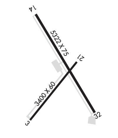
| Lat: N 3431.1 Long: W 10922.7 Elev: 5737 Var: -12 Longest Runway: 5322 | ||
| AWOS: 134.22 CTAF: 122.8 | ||
| |||||||||||||||||||||||||||||||||||||||||||||||||||||||||||||
| |||||||||||||||||||||||||||||||||||||||||||||||||||||||||||||
| |||||||||||||||||||||||||||||||||||||||||||||||||||||||||||||
| Rwy | Rwy | |||||||
| 3400x60 | 3210' | 3400x60 | 3400' | |||||
| 5322x75 | 5322' | 5322x75 | 5230' | |||||
| Runway ID | Single Wheel | Double Wheel | Double Tandem Wheel | Dual Double Wheel |
| 03/21 | 55,000 | N/A | N/A | N/A |
| 14/32 | 90,000 | N/A | N/A | N/A |
| These numbers are Advisory and are not limits. The Airport Manager should have more accurate Weight Limits | ||||
 Airport Diagram might not be current. | |
| Facility Name: | ST JOHNS INDUSTRIAL AIR PARK |
| City Name: | ST JOHNS |
| County: | APACHE |
| State abbrev: | AZ |
| State Name: | ARIZONA |
| Ownership: | PUBLICLY OWNED |
| Use: | OPEN TO THE PUBLIC |
| Owner's Name: | CITY OF ST. JOHNS |
| Address: | P.O. BOX 455 |
| ST. JOHNS, AZ 85936 | |
| Owner's Phone: | 928-337-4517 |
| Manager's Name: | GARY LISTON |
| Address: | P.O. BOX 455 |
| ST. JOHNS, AZ 85936 | |
| Phone: | 928-337-4254; EMERG - 928-245-0391 |
| FAA Region: | WESTERN-PACIFIC |
| FAA Field Office: | PHX |
| Date | Sunrise | Sunset |
|---|---|---|
| 05/11/25 Sunday | 5:18 | 19:10 |
| 05/12/25 Monday | 5:17 | 19:11 |
| 05/13/25 Tuesday | 5:17 | 19:12 |
| 05/14/25 Wednesday | 5:16 | 19:12 |
| 05/15/25 Thursday | 5:15 | 19:13 |
| 05/16/25 Friday | 5:14 | 19:14 |
| 05/17/25 Saturday | 5:14 | 19:15 |
| 05/18/25 Sunday | 5:13 | 19:15 |
| 05/19/25 Monday | 5:12 | 19:16 |
| 05/20/25 Tuesday | 5:12 | 19:17 |
| 05/21/25 Wednesday | 5:11 | 19:18 |
| 05/22/25 Thursday | 5:10 | 19:18 |
| 05/23/25 Friday | 5:10 | 19:19 |
| 05/24/25 Saturday | 5:09 | 19:20 |
| Airport Attendance Schedule | 7 Days A Week 0700-1700 |
| Airport Status | OPERATIONAL (This Status can change at any time - please check NOTAMS) |
| Airport Lighting Schedule | ACTVT REIL RWY 14 & 32; PAPI RWY 14 & 32; MIRL RWY 03/21 & 14/32 - CTAF. |
| Airport Storage Available | Tie Downs, Hanger |
| Extra Services Available | NONE |
| Wind Indicator | YES - (lighted) |
| Control Tower | NO |
| CTAF Frequency | 122.800 |
| Unicom Frequency | 122.800 |
| Rotating Beacon Color | WG |
| Segmented Circle | YES |
| Landing Fee |
| Airport Inspected | STATE - performed by PRIVATE CONTRACT PERSONNEL |
| Inspection Date | 04/11/2024 |
| Type of Fuel Available | Grade 100LL, JET A |
| Airframe Repair Service | None |
| Power Plant Repair Service | None |
| Latitude | N3431.1 |
| Longitude | W10922.7 (ESTIMATED) |
| Arpt Elevation | 5736ft (SURVEYED) |
| Magnetic Variation | 12E |
| 1 miles N | of ST JOHNS |
| Traffic Pattern Altitude | |
| Sectional Chart | PHOENIX |
| Operations (Reported) | Yearly | Avg. Daily |
|---|---|---|
| General Aviation Transient | 0 | 0 |
| General Aviation Local | 0 | 0 |
| Air Taxi | 0 | 0 |
| Commerical | 0 | 0 |
| Commuter | 0 | 0 |
| Military | 0 | 0 |
| Aircraft based on Field | |
|---|---|
| General Aviation Singles | 0 |
| General Aviation Multi | 0 |
| Jet Aircraft | 0 |
| General Aviation Helicopters | 0 |
| Military Aircraft | 0 |
| Gliders | 0 |
| Ultralights | 0 |
| FSS on field | NO |
| FSS tie-in | PRESCOTT |
| FSS Phone | 1-800-WX-BRIEF |
| Who issues Notams | SJN |
| Notam D service at airport | YES |
| ARTCC Name | ALBUQUERQUE |
| Airport Certification | |
| Aircraft Rescue & Firefighting Index | None |
| Airport of Entry | No |
| Custom Landing Rights | No |
| Joint Civil/Military | No |
| Military Landing rights | YES |
| NATIONAL PLAN OF INTEGRATED AIRPORT SYSTEMS (NPIAS) |
| GRANT AGREEMENTS UNDER FAAP/ADAP/AIP |
| ASSURANCES PURSUANT TO TITLE VI, CIVIL RIGHTS ACT OF 1964 |
| MIL TFC INVOF ARPT. |
| RWY 14/32 PARL TWY REFLECTORS FULL LEN BOTH SIDES. |
| FOR CD IF UNA TO CTC ON FSS FREQ, CTC ALBUQUERQUE ARTCC AT 505-856-4561. |
| RWY 14/3 2 RWY 32 CALM WIND RWY. |
| RWY 03 200 FT GRAVEL CLEAR AREA. |
Airport Communications & Frequencies:
| |||||||||
| Runway: 03 | Runway: 21 | ||
| Mag heading: | 25° | Mag heading: | 205° |
| Rwy Slope: | .23% Up | Rwy Slope: | -.23% Down |
| Approach: | Approach: | ||
| Pattern: | Left Traffic | Pattern: | Left Traffic |
| Markings: | BASIC | Markings: | BASIC |
| Marking Condition: | POOR; FADED & MISG. | Marking Condition: | POOR; FADED & MISG. |
| Arresting Dev: | Arresting Dev: | ||
| Lat & Long: | N3430.8 W10923.0 | Lat. & Long.: | N3431.2 W10922.6 |
| Elev: | 5727.0 ft. MSL | Elev: | 5734.7 ft. MSL |
| TCH: | TCH: | ||
| Visual Glide Path: | Visual Glide Path: | ||
| Displaced Threshold: | 190 feet | Displaced Threshold: | No |
| Touchdown Zone: | YES | Touchdown Zone: | YES |
| Touchdown Elev.: | 5735.7 feet | Touchdown Elev.: | 5735.7 feet |
| Visual Glide Slope: | Visual Glide Slope: | ||
| RVR Equipment: | RVR Equipment: | ||
| RVV Equipment: | NO | RVV Equipment: | NO |
| Approach Lights: | Approach Lights: | ||
| REIL: | NO | REIL: | NO |
| Centerline Lights: | NO | Centerline Lights: | NO |
| Touchdown lights: | NO | Touchdown lights: | NO |
| Runway Category: | Runway with a Visual Approach | Runway Category: | Runway with a Visual Approach |
| Declared Distances: | Declared Distances: | ||
| Obstructions: | TREE | Obstructions: | |
| Marked: | NOT Marked/Lighted | Marked: | |
| Clearance slope: | 4:1; APCH RATIO 10:1 TO DTHR; 58 FT TREE 630 FT FM RWY END 50 FT L OF CNTRLN. | Clearance slope: | 50:1 |
| Obstruction height: | 58 feet AGL | Obstruction height: | |
| Dist. from runway: | 440 feet | Dist. from runway: | |
| Centerline offset: | 50 left of centerline | Centerline offset: | |
| Comments: | Comments: | 5 FT DIRT PILE 100 FT FM THR 85 FT R OF CNTRLN. |
| Runway: 14 | Runway: 32 | ||
| Mag heading: | 136° | Mag heading: | 316° |
| Rwy Slope: | .05% Up | Rwy Slope: | -.05% Down |
| Approach: | Approach: | ||
| Pattern: | Left Traffic | Pattern: | Left Traffic |
| Markings: | NONPRECISION INSTRUMENT | Markings: | NONPRECISION INSTRUMENT |
| Marking Condition: | POOR | Marking Condition: | POOR |
| Arresting Dev: | Arresting Dev: | ||
| Lat & Long: | N3431.6 W10923.0 | Lat. & Long.: | N3430.8 W10922.4 |
| Elev: | 5734.1 ft. MSL | Elev: | 5736.5 ft. MSL |
| TCH: | 40 ft. AGL | TCH: | 40 ft. AGL |
| Visual Glide Path: | 3.00 degrees | Visual Glide Path: | 3.00 degrees |
| Displaced Threshold: | No | Displaced Threshold: | 92 feet |
| Touchdown Zone: | YES | Touchdown Zone: | YES |
| Touchdown Elev.: | 5736.0 feet | Touchdown Elev.: | 5736.5 feet |
| Visual Glide Slope: | 2-Light PAPI on LEFT side of Runway | Visual Glide Slope: | 2-Light PAPI on RIGHT side of Runway |
| RVR Equipment: | RVR Equipment: | ||
| RVV Equipment: | NO | RVV Equipment: | NO |
| Approach Lights: | Approach Lights: | ||
| REIL: | YES | REIL: | YES |
| Centerline Lights: | NO | Centerline Lights: | NO |
| Touchdown lights: | NO | Touchdown lights: | NO |
| Runway Category: | Runway with a Non-precision Approach | Runway Category: | Runway with a Non-precision Approach |
| Declared Distances: | Declared Distances: | ||
| Obstructions: | Obstructions: | POLE | |
| Marked: | Marked: | LIGHTED | |
| Clearance slope: | 20:1 | Clearance slope: | 10:1; APCH RATIO 27:1 AT DTHR. |
| Obstruction height: | Obstruction height: | 17 feet AGL | |
| Dist. from runway: | Dist. from runway: | 375 feet | |
| Centerline offset: | Centerline offset: | 135 feet right of centerline | |
| Comments: | Comments: | 0-12 FT FENCE 0-200 FT FM THR 135-150 FT R OF CNTRLN. +10 FT ROAD 0-150 FT FM RWY END ACRS THR. |
Thanks for using FltPlan.com
all rights reserved © 1999-2025 by Flight Plan LLC