| MORRISTOWN MUNI MORRISTOWN NJ |
| |
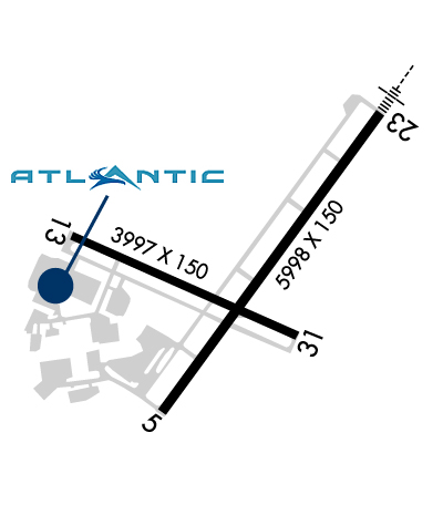
| Lat: N 4048.0 Long: W 07424.9 Elev: 187 Var: +13 Longest Runway: 5998 | ||
| Clr Del: 128.6 Dept. ATIS: 124.25 Arr. ATIS: 124.25 Ground: 134.2 Tower: 118.1 | ||
| |||||||||||||||||||||||||||||||||||||||
| |||||||||||||||||||||||||||||||||||||||
| |||||||||||||||||||||||||||||||||||||||
| |||||||||||||||||||||||||||||||||||||||
| Rwy | Rwy | |||||||
| 5998x150 | 5998' | 5998x150 | 5998' | 110.30 - 229° | ||||
| 3997x150 | 3997' | 3997x150 | 3997' | |||||
| Runway ID | Single Wheel | Double Wheel | Double Tandem Wheel | Dual Double Wheel |
| 05/23 | 30,000 | 80,000 | N/A | N/A |
| 13/31 | 30,000 | N/A | N/A | N/A |
| These numbers are Advisory and are not limits. The Airport Manager should have more accurate Weight Limits | ||||
 Airport Diagram might not be current. | |
| Facility Name: | MORRISTOWN MUNI |
| City Name: | MORRISTOWN |
| County: | MORRIS |
| State abbrev: | NJ |
| State Name: | NEW JERSEY |
| Ownership: | PUBLICLY OWNED |
| Use: | OPEN TO THE PUBLIC |
| Owner's Name: | TOWN OF MORRISTOWN |
| Address: | 110 SOUTH STREET |
| MORRISTOWN, NJ 07960 | |
| Owner's Phone: | 973-292-6626 |
| Manager's Name: | SCOTT MCMAHON |
| Address: | DM AIRPORTS, LTD., 8 AIRPORT ROAD |
| MORRISTOWN, NJ 07960 | |
| Phone: | 973-538-6400 |
| FAA Region: | EASTERN |
| FAA Field Office: | HAR |
| Date | Sunrise | Sunset |
|---|---|---|
| 09/24/21 Friday | 6:47 | 18:52 |
| 09/25/21 Saturday | 6:48 | 18:50 |
| 09/26/21 Sunday | 6:49 | 18:48 |
| 09/27/21 Monday | 6:50 | 18:47 |
| 09/28/21 Tuesday | 6:51 | 18:45 |
| 09/29/21 Wednesday | 6:52 | 18:43 |
| 09/30/21 Thursday | 6:53 | 18:42 |
| 10/01/21 Friday | 6:54 | 18:40 |
| 10/02/21 Saturday | 6:55 | 18:38 |
| 10/03/21 Sunday | 6:56 | 18:37 |
| 10/04/21 Monday | 6:57 | 18:35 |
| 10/05/21 Tuesday | 6:58 | 18:34 |
| 10/06/21 Wednesday | 6:59 | 18:32 |
| 10/07/21 Thursday | 7:00 | 18:30 |
| Airport Attendance Schedule | 7 Days A Week 0645-2230 |
| Airport Status | OPERATIONAL (This Status can change at any time - please check NOTAMS) |
| Airport Lighting Schedule | DUSK-DAWN; ACTVT HIRL RWY 05/23, MIRL RW 13/31, REIL RWY 05 & 31, MALSR RWY 23 & PAPI RWY 31 - CTAF. |
| Airport Storage Available | Tie Downs, Hanger |
| Extra Services Available | Charter, Flight Instruction, Aircraft Rental |
| Wind Indicator | YES - (lighted) |
| Control Tower | YES |
| CTAF Frequency | 118.100; WHEN TWR CLSD ALL ACFT AND VEHICLES MUST STATE INTNS ON CTAF BFR OPS ON ANY RWY. |
| Unicom Frequency | |
| Rotating Beacon Color | CLEAR-GREEN (Light Land Airport) |
| Segmented Circle | YES |
| Landing Fee | YES |
| Airport Inspected | STATE - performed by STATE AERONAUTICAL PERSONNEL |
| Inspection Date | 09/23/2020 |
| Type of Fuel Available | Grade 100LL, JET A (freeze point -40C), JET A; -A O-128 AVOIL AVBL. |
| Airframe Repair Service | NONE |
| Power Plant Repair Service | NONE |
| Latitude | N4048.0 |
| Longitude | W07424.9 (ESTIMATED) |
| Arpt Elevation | 186ft (SURVEYED) |
| Magnetic Variation | 13W |
| 3 miles E | of MORRISTOWN |
| Traffic Pattern Altitude | TPA 1013 LIGHT ACFT, 1513 HEAVY ACFT. |
| Sectional Chart | NEW YORK |
| Operations (Reported) | Yearly | Avg. Daily |
|---|---|---|
| General Aviation Transient | 35750 | 98 |
| General Aviation Local | 32670 | 90 |
| Air Taxi | 8325 | 23 |
| Commerical | 0 | 0 |
| Commuter | 0 | 0 |
| Military | 125 | 0 |
| Aircraft based on Field | |
|---|---|
| General Aviation Singles | 60 |
| General Aviation Multi | 14 |
| Jet Aircraft | 67 |
| General Aviation Helicopters | 7 |
| Military Aircraft | 0 |
| Gliders | 0 |
| Ultralights | 0 |
| FSS on field | NO |
| FSS tie-in | MILLVILLE |
| FSS Phone | 1-800-WX-BRIEF |
| Who issues Notams | MMU |
| Notam D service at airport | YES |
| ARTCC Name | NEW YORK |
| Airport Certification | |
| Aircraft Rescue & Firefighting Index | ARFF SVCS AVBL 24 HRS DAILY. FOR ARFF SVCS WHEN ATCT CLSD CTC ARFF STATION; CTAF OR 973-455-1953. |
| Airport of Entry | YES |
| Custom Landing Rights | No; US CUSTOMS USER FEE ARPT. |
| Joint Civil/Military | No |
| Military Landing rights | YES |
| NATIONAL PLAN OF INTEGRATED AIRPORT SYSTEMS (NPIAS) |
| GRANT AGREEMENTS UNDER FAAP/ADAP/AIP |
| ASSURANCES PURSUANT TO TITLE VI, CIVIL RIGHTS ACT OF 1964 |
| AGREEMENT UNDER DLAND OR DCLA HAS EXPIRED. |
| BIRDS & DEER ON & INVOF ARPT. |
| ARFF SVCS AVBL 24 HRS DAILY. FOR ARFF SVCS WHEN ATCT CLSD CTC ARFF STATION; CTAF OR 973-455-1953. |
| ALL ARRIVAL/DEPARTURE ACFT FOLLOW MANUFACTURERS RECOMMENDED PROCEDURES FOR QUIET OPNS & MINIMUM NOISE. |
| ROUTE 80 VISUAL APCH PREFERRED FOR RY 23. |
| HELICOPTER OPNS OVER RESIDENTIAL AREAS BLO 1000 FT MSL SHOULD BE AVOIDED. |
| STAGE I DEPARTURE FEE 2300-0645. |
| DURG SNOW REMOVAL OPNS 15 MINUTE PRIOR NOTICE REQUIRED ON 118.1 & NO PRACTICE LOW APCHS OR TOUCH & GO LDGS. |
| INBOUND TFC REQUEST FBO SVCS, INSTRUCTIONS & RAMP ADVISORIES 30 MINUTES PRIOR TO ARRIVAL. AFTER LDG CTC FBO AGAIN 129.6 FOR PREFERRED RAMP ENTRANCE TO DELTA OR JULIET TWYS. |
| TAXILANE K N OF LYNX FBO RAMP, NO HEL OR ACFT WITH A WINGSPAN GTR THAN 50 FT. |
| VOLUNTARY NOISE ABATEMENT PROC INCLUDE AVOIDING TGL OPS ON RWY 13-31. |
| NOISE ABATEMENT PROC IN EFCT; CTC NOISE ABATEMENT OFFICE 973-538-3366 EXTN 122. |
| FOR CD WHEN ATCT IS CLSD CTC NEW YORK APCH AT 800-645-3206. |
| US CUSTOMS AVBL MON-FRI 0800-1600; BTN 1601-0759 & WKENDS CALL 973-267-0302 FOR APPOINTMENT. MORRISTOWN CUSTOMS ASSOCIATION FEES APPLY; CTC AMGR 973-538-6400 FOR DETAILS. |
| NO TURBOJET LNDG ON RWY 13 & 31 UNLESS THE X-WIND VELOCITY FOR RWY 5/23 EXCEEDS 16 KNOTS. |
| ACFT CARRYING EXPLOSIVE CARGO PPR BEFORE LDG - CALL 973-538-6400. |
| FLIGHT NOTIFICATION SVC (ADCUS) AVBL. |
| U.S. CUSTOMS USER FEE ARPT. |
Airport Communications & Frequencies:
| |||||||||||||||||||||||||||||
| Runway: 05 | Runway: 23 | ||
| Mag heading: | 49° | Mag heading: | 229° |
| Rwy Slope: | .02% Up | Rwy Slope: | -.02% Down |
| Approach: | Approach: | ILS | |
| Pattern: | Left Traffic | Pattern: | Left Traffic |
| Markings: | PRECISION INSTRUMENT | Markings: | PRECISION INSTRUMENT |
| Marking Condition: | GOOD | Marking Condition: | GOOD |
| Arresting Dev: | Arresting Dev: | ||
| Lat & Long: | N4047.6 W07425.2 | Lat. & Long.: | N4048.4 W07424.4 |
| Elev: | 181.8 ft. MSL | Elev: | 182.8 ft. MSL |
| TCH: | TCH: | ||
| Visual Glide Path: | Visual Glide Path: | ||
| Displaced Threshold: | No | Displaced Threshold: | No |
| Touchdown Zone: | YES | Touchdown Zone: | YES |
| Touchdown Elev.: | 184.6 feet | Touchdown Elev.: | 183.8 feet |
| Visual Glide Slope: | Visual Glide Slope: | ||
| RVR Equipment: | RVR Equipment: | ||
| RVV Equipment: | NO | RVV Equipment: | NO |
| Approach Lights: | Approach Lights: | MALSR - 1,400 foot medium intensity approach lighting system with runway alignment indicator lights | |
| REIL: | YES | REIL: | NO |
| Centerline Lights: | NO | Centerline Lights: | NO |
| Touchdown lights: | NO | Touchdown lights: | NO |
| Runway Category: | Runway with a Non-precision Approach having visibility minimums greater than 3/4 mile | Runway Category: | Precision Instrument Runway |
| Declared Distances: | Declared Distances: | ||
| Obstructions: | TREES | Obstructions: | |
| Marked: | NOT Marked/Lighted | Marked: | |
| Clearance slope: | 18:1 | Clearance slope: | 50:1 |
| Obstruction height: | 102 feet AGL | Obstruction height: | |
| Dist. from runway: | 2100 feet | Dist. from runway: | |
| Centerline offset: | Centerline offset: | ||
| Comments: | Comments: |
| Runway: 13 | Runway: 31 | ||
| Mag heading: | 127° | Mag heading: | 307° |
| Rwy Slope: | -.13% Down | Rwy Slope: | .13% Up |
| Approach: | Approach: | ||
| Pattern: | Left Traffic | Pattern: | Left Traffic |
| Markings: | BASIC | Markings: | BASIC |
| Marking Condition: | GOOD | Marking Condition: | GOOD |
| Arresting Dev: | Arresting Dev: | ||
| Lat & Long: | N4048.1 W07425.5 | Lat. & Long.: | N4047.8 W07424.7 |
| Elev: | 186.5 ft. MSL | Elev: | 181.3 ft. MSL |
| TCH: | TCH: | 39 ft. AGL | |
| Visual Glide Path: | Visual Glide Path: | 3.50 degrees | |
| Displaced Threshold: | No | Displaced Threshold: | No |
| Touchdown Zone: | YES | Touchdown Zone: | YES |
| Touchdown Elev.: | 186.6 feet | Touchdown Elev.: | 183.9 feet |
| Visual Glide Slope: | Visual Glide Slope: | 2-Light PAPI on LEFT side of Runway | |
| RVR Equipment: | RVR Equipment: | ||
| RVV Equipment: | NO | RVV Equipment: | NO |
| Approach Lights: | Approach Lights: | ||
| REIL: | NO | REIL: | YES |
| Centerline Lights: | NO | Centerline Lights: | NO |
| Touchdown lights: | NO | Touchdown lights: | NO |
| Runway Category: | Runway with a Visual Approach | Runway Category: | Runway with a Visual Approach |
| Declared Distances: | Declared Distances: | ||
| Obstructions: | TREES | Obstructions: | TREES |
| Marked: | NOT Marked/Lighted | Marked: | NOT Marked/Lighted |
| Clearance slope: | 2:1 | Clearance slope: | 16:1 |
| Obstruction height: | 49 feet AGL | Obstruction height: | 91 feet AGL |
| Dist. from runway: | 320 feet | Dist. from runway: | 1690 feet |
| Centerline offset: | 240 right of centerline | Centerline offset: | 330 feet left of centerline |
| Comments: | Comments: |
Thanks for using FltPlan.com
all rights reserved © 1999-2021 by Flight Plan LLC