
| STILLWATER RGNL STILLWATER OK |
| |
| Lat: N 3609.7 Long: W 09705.2 Elev: 1000 Var: -05 Longest Runway: 7401 | ||
| AWOS: 135.72 Ground: 121.6 Tower: 125.35 | ||
| ||||||||||||||||||||||||||||||||||||||||||||||||||||||||||||||||||||
| ||||||||||||||||||||||||||||||||||||||||||||||||||||||||||||||||||||
| ||||||||||||||||||||||||||||||||||||||||||||||||||||||||||||||||||||
| Rwy | Rwy | |||||||
| 5002x75 | 5002' | 5002x75 | 5002' | |||||
| 7401x100 | 7401' | 109.15 - 174° | 7401x100 | 7401' | ||||
| Runway ID | Single Wheel | Double Wheel | Double Tandem Wheel | Dual Double Wheel |
| 04/22 | 34,000 | 60,000 | N/A | N/A |
| 17/35 | 100,000 | 157,000 | 310,000 | N/A |
| These numbers are Advisory and are not limits. The Airport Manager should have more accurate Weight Limits | ||||
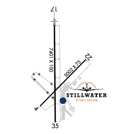 Airport Diagram might not be current. | |
| Facility Name: | STILLWATER RGNL |
| City Name: | STILLWATER |
| County: | PAYNE |
| State abbrev: | OK |
| State Name: | OKLAHOMA |
| Ownership: | PUBLICLY OWNED |
| Use: | OPEN TO THE PUBLIC |
| Owner's Name: | CITY OF STILLWATER |
| Address: | 723 SOUTH LEWIS |
| STILLWATER, OK 74074 | |
| Owner's Phone: | 405-372-0025 |
| Manager's Name: | KELLIE REED |
| Address: | 3304 N AIRPORT INDUSTRIAL ACCESS RD |
| STILLWATER, OK 74075 | |
| Phone: | 405-533-8425 |
| FAA Region: | SOUTHWEST |
| FAA Field Office: | AOK |
| Date | Sunrise | Sunset |
|---|---|---|
| 05/04/26 Monday | 6:33 | 20:18 |
| 05/05/26 Tuesday | 6:31 | 20:19 |
| 05/06/26 Wednesday | 6:30 | 20:20 |
| 05/07/26 Thursday | 6:29 | 20:21 |
| 05/08/26 Friday | 6:29 | 20:22 |
| 05/09/26 Saturday | 6:28 | 20:22 |
| 05/10/26 Sunday | 6:27 | 20:23 |
| 05/11/26 Monday | 6:26 | 20:24 |
| 05/12/26 Tuesday | 6:25 | 20:25 |
| 05/13/26 Wednesday | 6:24 | 20:26 |
| 05/14/26 Thursday | 6:23 | 20:27 |
| 05/15/26 Friday | 6:22 | 20:27 |
| 05/16/26 Saturday | 6:22 | 20:28 |
| 05/17/26 Sunday | 6:21 | 20:29 |
| Airport Attendance Schedule | 7 Days A Week 0800-2200; AFT HR FUEL - 405-377-5326. |
| Airport Status | OPERATIONAL (This Status can change at any time - please check NOTAMS) |
| Airport Lighting Schedule | ACTVT MALSR RWY 17; REIL RWY 35; PAPI RWY 22; MIRL RWY 04/22 & 17/35 - CTAF. MIRL RWY 17/35 PRESET LOW INTST; INCR INTST - CTAF. |
| Airport Storage Available | Tie Downs, Hanger |
| Extra Services Available | Air Freight, Flight Instruction, Aircraft Rental, Aircraft Sales |
| Wind Indicator | YES - (lighted) |
| Control Tower | YES |
| CTAF Frequency | 125.350 |
| Unicom Frequency | 122.950 |
| Rotating Beacon Color | WG |
| Segmented Circle | NO |
| Landing Fee | NO |
| Airport Inspected | FEDERAL - performed by FAA AIRPORTS FIELD PERSONNEL |
| Inspection Date | 03/16/2026 |
| Type of Fuel Available | Grade 100LL, JET A (freeze point -40C) |
| Airframe Repair Service | MAJOR |
| Power Plant Repair Service | MAJOR |
| Latitude | N3609.7 |
| Longitude | W09705.2 (ESTIMATED) |
| Arpt Elevation | 1000ft (SURVEYED) |
| Magnetic Variation | 05E |
| 3 miles NW | of STILLWATER |
| Traffic Pattern Altitude | 800; TPA LGT ACFT 800 FT AGL, TURBO PROPS/JETS 1500 FT AGL. |
| Sectional Chart | WICHITA |
| Operations (Reported) | Yearly | Avg. Daily |
|---|---|---|
| General Aviation Transient | 0 | 0 |
| General Aviation Local | 0 | 0 |
| Air Taxi | 0 | 0 |
| Commerical | 0 | 0 |
| Commuter | 0 | 0 |
| Military | 0 | 0 |
| Aircraft based on Field | |
|---|---|
| General Aviation Singles | 0 |
| General Aviation Multi | 0 |
| Jet Aircraft | 0 |
| General Aviation Helicopters | 0 |
| Military Aircraft | 0 |
| Gliders | 0 |
| Ultralights | 0 |
| FSS on field | NO |
| FSS tie-in | MC ALESTER |
| FSS Phone | 1-800-WX-BRIEF |
| Who issues Notams | SWO |
| Notam D service at airport | YES |
| ARTCC Name | KANSAS CITY |
| Airport Certification | AIRPORT RECEIVING SCHEDULED AIR CARRIER SERVICE FROM CARRIERS CERTIFICATED BY THE CIVIL AERONAUTICS BOARD; 24 HRS PPR FOR UNSKED ACFT OPS WITH MORE THAN 9 PAX CALL AMGR 405-533-2222. |
| Aircraft Rescue & Firefighting Index | AIRPORT HAS A CERTIFICATE UNDER CFR PART 139 |
| Airport of Entry | No |
| Custom Landing Rights | No |
| Joint Civil/Military | No |
| Military Landing rights | YES |
| NATIONAL PLAN OF INTEGRATED AIRPORT SYSTEMS (NPIAS) |
| GRANT AGREEMENTS UNDER FAAP/ADAP/AIP |
| ASSURANCES PURSUANT TO TITLE VI, CIVIL RIGHTS ACT OF 1964 |
| AGREEMENT UNDER DLAND OR DCLA HAS EXPIRED. |
| STUDENT OPS & BIRDS ON & INVOF ARPT. |
| ALL RAMPS UNCONTROLLED. |
| AFT HRS FUEL AVBL WITH PPR; CTC 405-624-5463. |
| FOR GA TSNT PRKG ON HANGAR 1 RAMP CTC FBO ON UNICOM OR FONE 405-624-5463. |
| OPNS ABV PCR VALUE BY PPR. |
| ARFF INDEX B MAINTAINED; ARFF INDEX C PPR. |
| PTN OF TWY F NORTH OF T-HNGR 2 NOT VSBL FROM ATCT. |
| FOR CD IF UNA TO CTC ON FSS FREQ, CTC KANSAS CITY ARTCC AT 913-254-8508. |
| RWY 17/3 5 STRENGTHS BASED ON RESTRICTED OPS. |
| RWY 04/2 2 PCR VALUE: 158/R/C/W/T |
| RWY 17/3 5 PCR VALUE: 582/R/C/W/T |
Airport Communications & Frequencies:
| |||||||||||||
| Runway: 04 | Runway: 22 | ||
| Mag heading: | 40° | Mag heading: | 220° |
| Rwy Slope: | .50% Up | Rwy Slope: | -.50% Down |
| Approach: | Approach: | ||
| Pattern: | Left Traffic | Pattern: | Left Traffic |
| Markings: | BASIC | Markings: | BASIC |
| Marking Condition: | GOOD | Marking Condition: | GOOD |
| Arresting Dev: | Arresting Dev: | ||
| Lat & Long: | N3609.3 W09705.4 | Lat. & Long.: | N3609.9 W09704.7 |
| Elev: | 960.9 ft. MSL | Elev: | 985.7 ft. MSL |
| TCH: | 35 ft. AGL | TCH: | 39 ft. AGL |
| Visual Glide Path: | 3.00 degrees | Visual Glide Path: | 3.00 degrees |
| Displaced Threshold: | No | Displaced Threshold: | No |
| Touchdown Zone: | YES | Touchdown Zone: | YES |
| Touchdown Elev.: | 965.8 feet | Touchdown Elev.: | 985.7 feet |
| Visual Glide Slope: | 4-Light PAPI on LEFT side of Runway; UNUSBL BYD 9 DEGS RIGHT OF CNTRLN. | Visual Glide Slope: | 4-Light PAPI on LEFT side of Runway |
| RVR Equipment: | RVR Equipment: | ||
| RVV Equipment: | NO | RVV Equipment: | NO |
| Approach Lights: | Approach Lights: | ||
| REIL: | NO | REIL: | NO |
| Centerline Lights: | NO | Centerline Lights: | NO |
| Touchdown lights: | NO | Touchdown lights: | NO |
| Runway Category: | Runway with a Visual Approach | Runway Category: | Runway with a Visual Approach |
| Declared Distances: | TORA:5002' TODA:5002' ASDA:5002' LDA:5002' | Declared Distances: | TORA:5002' TODA:5002' ASDA:5002' LDA:5002' |
| Obstructions: | GND | Obstructions: | |
| Marked: | NOT Marked/Lighted | Marked: | |
| Clearance slope: | 45:1 | Clearance slope: | 50:1 |
| Obstruction height: | 3 feet AGL | Obstruction height: | |
| Dist. from runway: | 520 feet | Dist. from runway: | |
| Centerline offset: | Centerline offset: | ||
| Comments: | Comments: |
| Runway: 17 | Runway: 35 | ||
| Mag heading: | 174° | Mag heading: | 354° |
| Rwy Slope: | -.46% Down | Rwy Slope: | .46% Up |
| Approach: | ILS/DME | Approach: | |
| Pattern: | Left Traffic | Pattern: | Left Traffic |
| Markings: | PRECISION INSTRUMENT | Markings: | PRECISION INSTRUMENT |
| Marking Condition: | GOOD | Marking Condition: | GOOD |
| Arresting Dev: | Arresting Dev: | ||
| Lat & Long: | N3610.3 W09705.2 | Lat. & Long.: | N3609.1 W09705.2 |
| Elev: | 1000.3 ft. MSL | Elev: | 966.0 ft. MSL |
| TCH: | 50 ft. AGL | TCH: | 38 ft. AGL |
| Visual Glide Path: | 3.00 degrees | Visual Glide Path: | 3.00 degrees |
| Displaced Threshold: | No | Displaced Threshold: | No |
| Touchdown Zone: | YES | Touchdown Zone: | YES |
| Touchdown Elev.: | 1000.3 feet | Touchdown Elev.: | 966.0 feet |
| Visual Glide Slope: | 4-Light PAPI on LEFT side of Runway; UNUSBL BYD 9 DEGS LEFT & RIGHT OF CNTRLN. | Visual Glide Slope: | 4-Light PAPI on LEFT side of Runway; UNUSBL BYD 9 DEGS LEFT & 8 DEGS RIGHT OF CNTRLN. |
| RVR Equipment: | RVR Equipment: | ||
| RVV Equipment: | NO | RVV Equipment: | NO |
| Approach Lights: | MALSR - 1,400 foot medium intensity approach lighting system with runway alignment indicator lights | Approach Lights: | |
| REIL: | NO | REIL: | YES |
| Centerline Lights: | NO | Centerline Lights: | NO |
| Touchdown lights: | NO | Touchdown lights: | NO |
| Runway Category: | Precision Instrument Runway | Runway Category: | Precision Instrument Runway |
| Declared Distances: | TORA:7401' TODA:7401' ASDA:7401' LDA:7401' | Declared Distances: | TORA:7401' TODA:7401' ASDA:7401' LDA:7401' |
Thanks for using FltPlan.com
all rights reserved © 1999-2026 by Flight Plan LLC