| COTTONWOOD COTTONWOOD AZ |
| |
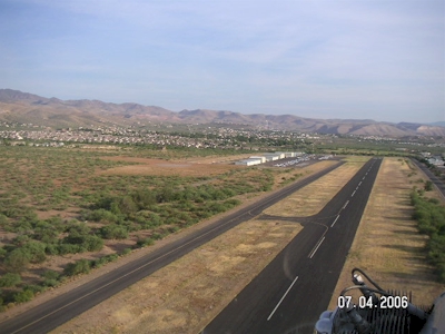
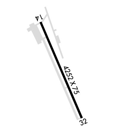
| Lat: N 3443.8 Long: W 11202.1 Elev: 3560 Var: -11 Longest Runway: 4250 | ||
| AWOS: 122.7 CTAF: 122.7 | ||
| ||||||||||||||||||||||||||||||||||||||||||||
| ||||||||||||||||||||||||||||||||||||||||||||
| ||||||||||||||||||||||||||||||||||||||||||||
| Rwy | Rwy | |||||||
| 4250x75 | 4250' | 4250x75 | 4250' | |||||
| Runway ID | Single Wheel | Double Wheel | Double Tandem Wheel | Dual Double Wheel |
| 14/32 | 4,000 | N/A | N/A | N/A |
| These numbers are Advisory and are not limits. The Airport Manager should have more accurate Weight Limits | ||||
 Airport Diagram might not be current. | |
| Facility Name: | COTTONWOOD |
| City Name: | COTTONWOOD |
| County: | YAVAPAI |
| State abbrev: | AZ |
| State Name: | ARIZONA |
| Ownership: | PUBLICLY OWNED |
| Use: | OPEN TO THE PUBLIC |
| Owner's Name: | CITY OF COTTONWOOD |
| Address: | 827 N MAIN ST |
| COTTONWOOD, AZ 86326 | |
| Owner's Phone: | 928-634-5526 |
| Manager's Name: | MARK WILLIAMS |
| Address: | 1001 W. MINGUS AVENUE |
| COTTONWOOD, AZ 86326 | |
| Phone: | 928-340-2722 |
| FAA Region: | WESTERN-PACIFIC |
| FAA Field Office: | PHX |
| Date | Sunrise | Sunset |
|---|---|---|
| 09/24/21 Friday | 6:17 | 18:22 |
| 09/25/21 Saturday | 6:18 | 18:21 |
| 09/26/21 Sunday | 6:19 | 18:19 |
| 09/27/21 Monday | 6:20 | 18:18 |
| 09/28/21 Tuesday | 6:20 | 18:17 |
| 09/29/21 Wednesday | 6:21 | 18:15 |
| 09/30/21 Thursday | 6:22 | 18:14 |
| 10/01/21 Friday | 6:23 | 18:12 |
| 10/02/21 Saturday | 6:23 | 18:11 |
| 10/03/21 Sunday | 6:24 | 18:10 |
| 10/04/21 Monday | 6:25 | 18:08 |
| 10/05/21 Tuesday | 6:26 | 18:07 |
| 10/06/21 Wednesday | 6:27 | 18:05 |
| 10/07/21 Thursday | 6:27 | 18:04 |
| Airport Attendance Schedule | 7 Days A Week 0800-1700 |
| Airport Status | OPERATIONAL (This Status can change at any time - please check NOTAMS) |
| Airport Lighting Schedule | ACTVT REIL RWY 14, 32; PAPI RWY 32; MIRL RWY 14/32 - CTAF. |
| Airport Storage Available | Tie Downs, Hanger |
| Extra Services Available | Avionics, Flight Instruction, Aircraft Rental |
| Wind Indicator | YES - (lighted) |
| Control Tower | NO |
| CTAF Frequency | 122.700 |
| Unicom Frequency | 122.700 |
| Rotating Beacon Color | CLEAR-GREEN (Light Land Airport) |
| Segmented Circle | YES |
| Landing Fee | NO |
| Airport Inspected | STATE - performed by PRIVATE CONTRACT PERSONNEL |
| Inspection Date | 04/22/2019 |
| Type of Fuel Available | Grade 100LL, JET A-1 (icing inhibitor, freeze point -50C); -10FUEL AVBL 24 HRS WITH MAJOR CREDIT CARD 100 LL ONLY. JET A AFTER HOURS $100 CALL OUT FEE. |
| Airframe Repair Service | MINOR |
| Power Plant Repair Service | MINOR |
| Latitude | N3443.8 |
| Longitude | W11202.1 (ESTIMATED) |
| Arpt Elevation | 3560ft (SURVEYED) |
| Magnetic Variation | 11E |
| 1 miles SW | of COTTONWOOD |
| Traffic Pattern Altitude | TPA HELICOPTER 4050 MSL/500 AGL; SINGLE 4350 MSL/800 AGL; MULTI 4550 MSL/1000 AGL; TURBINE 5050 MSL/1500 AGL. |
| Sectional Chart | PHOENIX |
| Operations (Reported) | Yearly | Avg. Daily |
|---|---|---|
| General Aviation Transient | 11500 | 32 |
| General Aviation Local | 8800 | 24 |
| Air Taxi | 330 | 1 |
| Commerical | 0 | 0 |
| Commuter | 0 | 0 |
| Military | 110 | 0 |
| Aircraft based on Field | |
|---|---|
| General Aviation Singles | 54 |
| General Aviation Multi | 5 |
| Jet Aircraft | 3 |
| General Aviation Helicopters | 11 |
| Military Aircraft | 0 |
| Gliders | 0 |
| Ultralights | 0 |
| FSS on field | NO |
| FSS tie-in | PRESCOTT |
| FSS Phone | 1-800-WX-BRIEF |
| Who issues Notams | PRC |
| Notam D service at airport | YES |
| ARTCC Name | ALBUQUERQUE |
| Airport Certification | |
| Aircraft Rescue & Firefighting Index | None |
| Airport of Entry | No |
| Custom Landing Rights | No |
| Joint Civil/Military | No |
| Military Landing rights | YES |
| NATIONAL PLAN OF INTEGRATED AIRPORT SYSTEMS (NPIAS) |
| GRANT AGREEMENTS UNDER FAAP/ADAP/AIP |
| ASSURANCES PURSUANT TO TITLE VI, CIVIL RIGHTS ACT OF 1964 |
| ACT DEP RY 14 MAINTAIN HEADING FOR 1 NM BYD DEP END & 500 FT AGL PRIOR TO TURNING. DEP RWY 32 MAINTAIN RWY HEADING FOR .6 NM AND 500 AGL PRIOR TO TURNING. CHECK CTAF FOR LOCAL FLT TRAINING RESTRICTIONS. |
| FOR CD CTC PHOENIX APCH AT 602-306-2565. |
| RWY 32 DESIGNATED CALM WIND RUNWAY. |
| HANG GLIDERS INVOF ARPT. |
| EMERG PHONE: 928-634-4246 (POLICE DISPATCH). |
| NO TOUCH & GO 30 MIN BEFORE SS UNTIL 30 MIN AFTER DAWN. |
| WILDLIFE ON OR INVOF ARPT. |
| RWY 14/3 2 300 FT PAVED STOPWAY EACH END OF RWY. |
Airport Communications & Frequencies:
| |||||||||||||||||
| Runway: 14 | Runway: 32 | ||
| Mag heading: | 145° | Mag heading: | 325° |
| Rwy Slope: | .96% Up | Rwy Slope: | -.96% Down |
| Approach: | Approach: | ||
| Pattern: | Left Traffic | Pattern: | Right Traffic |
| Markings: | BASIC | Markings: | NONPRECISION INSTRUMENT |
| Marking Condition: | GOOD | Marking Condition: | GOOD |
| Arresting Dev: | Arresting Dev: | ||
| Lat & Long: | N3444.1 W11202.3 | Lat. & Long.: | N3443.5 W11201.9 |
| Elev: | 3519.4 ft. MSL | Elev: | 3560.3 ft. MSL |
| TCH: | TCH: | 41 ft. AGL | |
| Visual Glide Path: | Visual Glide Path: | 3.60 degrees | |
| Displaced Threshold: | No | Displaced Threshold: | No |
| Touchdown Zone: | YES | Touchdown Zone: | YES |
| Touchdown Elev.: | 3548.4 feet | Touchdown Elev.: | 3560.3 feet |
| Visual Glide Slope: | Visual Glide Slope: | 2-Light PAPI on LEFT side of Runway | |
| RVR Equipment: | RVR Equipment: | ||
| RVV Equipment: | NO | RVV Equipment: | NO |
| Approach Lights: | Approach Lights: | ||
| REIL: | YES | REIL: | YES |
| Centerline Lights: | NO | Centerline Lights: | NO |
| Touchdown lights: | NO | Touchdown lights: | NO |
| Runway Category: | Runway with a Visual Approach | Runway Category: | Runway with a Non-precision Approach |
| Declared Distances: | Declared Distances: | ||
| Obstructions: | Obstructions: | BRUSH | |
| Marked: | Marked: | NOT Marked/Lighted | |
| Clearance slope: | 50:1 | Clearance slope: | |
| Obstruction height: | Obstruction height: | 8 feet AGL | |
| Dist. from runway: | Dist. from runway: | 201 feet | |
| Centerline offset: | Centerline offset: | 125 feet left of centerline | |
| Comments: | Comments: | 12 FT BRUSH 50 TO 200 FT FM THLD, 120 TO 175 FT RIGHT OF CENTERLINE. 3 TO 15 FT BRUSH 30 TO 200 FT FM THLD, 140 TO 250 FT LEFT OF CENTERLINE. 1 TO 4 FT BERM, 30 TO 200 FT FM THLD, 125 TO 250 FT LEFT OF CENTERLINE. |
Thanks for using FltPlan.com
all rights reserved © 1999-2021 by Flight Plan LLC