
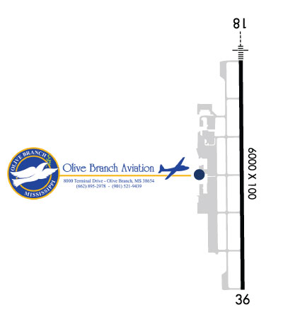
| OLIVE BRANCH OLIVE BRANCH MS |
| |
| Lat: N 3458.7 Long: W 08947.2 Elev: 402 Var: +01 Longest Runway: 6000 | ||
| Clr Del: 121.2/121.3 Dept. ATIS: 119.92 Arr. ATIS: 119.92 AWOS: 119.92 Ground: 121.2 Tower: 125.27 | ||
| ||||||||||||||||||||||||||||||||||||||||||||||||||||||||||||||||||||
| ||||||||||||||||||||||||||||||||||||||||||||||||||||||||||||||||||||
| ||||||||||||||||||||||||||||||||||||||||||||||||||||||||||||||||||||
| ||||||||||||||||||||||||||||||||||||||||||||||||||||||||||||||||||||
| Rwy | Rwy | |||||||
| 6000x100 | 6000' | 109.30 - 180° | 6000x100 | 6000' | 111.55 - 000° | |||
| Runway ID | Single Wheel | Double Wheel | Double Tandem Wheel | Dual Double Wheel |
| 18/36 | 50,000 | N/A | N/A | N/A |
| These numbers are Advisory and are not limits. The Airport Manager should have more accurate Weight Limits | ||||
 Airport Diagram might not be current. | |
| Facility Name: | OLIVE BRANCH |
| City Name: | OLIVE BRANCH |
| County: | DE SOTO |
| State abbrev: | MS |
| State Name: | MISSISSIPPI |
| Ownership: | PUBLICLY OWNED |
| Use: | OPEN TO THE PUBLIC |
| Owner's Name: | CITY OF OLIVE BRANCH |
| Address: | 9200 PIGEON ROOST ROAD |
| OLIVE BRANCH, MS 38654 | |
| Owner's Phone: | 662-895-2978 |
| Manager's Name: | GIL BOBO |
| Address: | 8000 TERMINAL DRIVE |
| OLIVE BRANCH, MS 38654 | |
| Phone: | 662-895-2978 |
| FAA Region: | SOUTHERN |
| FAA Field Office: | JAN |
| Date | Sunrise | Sunset |
|---|---|---|
| 09/24/21 Friday | 6:48 | 18:53 |
| 09/25/21 Saturday | 6:49 | 18:52 |
| 09/26/21 Sunday | 6:50 | 18:51 |
| 09/27/21 Monday | 6:51 | 18:49 |
| 09/28/21 Tuesday | 6:51 | 18:48 |
| 09/29/21 Wednesday | 6:52 | 18:46 |
| 09/30/21 Thursday | 6:53 | 18:45 |
| 10/01/21 Friday | 6:54 | 18:43 |
| 10/02/21 Saturday | 6:54 | 18:42 |
| 10/03/21 Sunday | 6:55 | 18:41 |
| 10/04/21 Monday | 6:56 | 18:39 |
| 10/05/21 Tuesday | 6:57 | 18:38 |
| 10/06/21 Wednesday | 6:58 | 18:36 |
| 10/07/21 Thursday | 6:58 | 18:35 |
| Airport Attendance Schedule | MON-FRI 0600-2100, SAT-SUN 0800-1700; CLOSED THANKSGIVING, CHRISTMAS & EASTER. |
| Airport Status | OPERATIONAL (This Status can change at any time - please check NOTAMS) |
| Airport Lighting Schedule | ACTVT MALSR RWY 18 - CTAF. |
| Airport Storage Available | Tie Downs, Hanger |
| Extra Services Available | Avionics, Flight Instruction, Aircraft Rental |
| Wind Indicator | YES - (unlit) |
| Control Tower | YES |
| CTAF Frequency | 125.275 |
| Unicom Frequency | 122.950 |
| Rotating Beacon Color | CLEAR-GREEN (Light Land Airport) |
| Segmented Circle | YES |
| Landing Fee | NO |
| Airport Inspected | STATE - performed by STATE AERONAUTICAL PERSONNEL |
| Inspection Date | 12/16/2020 |
| Type of Fuel Available | Grade 100LL, JET A (freeze point -40C); -10FUEL AVBL H24 WITH CREDIT CARD. |
| Airframe Repair Service | MAJOR |
| Power Plant Repair Service | MAJOR |
| Latitude | N3458.7 |
| Longitude | W08947.2 (ESTIMATED) |
| Arpt Elevation | 401ft (SURVEYED) |
| Magnetic Variation | 01W |
| 3 miles NE | of OLIVE BRANCH |
| Traffic Pattern Altitude | 1200 |
| Sectional Chart | MEMPHIS |
| Operations (Reported) | Yearly | Avg. Daily |
|---|---|---|
| General Aviation Transient | 26000 | 71 |
| General Aviation Local | 33000 | 90 |
| Air Taxi | 5500 | 15 |
| Commerical | 0 | 0 |
| Commuter | 0 | 0 |
| Military | 500 | 1 |
| Aircraft based on Field | |
|---|---|
| General Aviation Singles | 93 |
| General Aviation Multi | 19 |
| Jet Aircraft | 7 |
| General Aviation Helicopters | 1 |
| Military Aircraft | 0 |
| Gliders | 0 |
| Ultralights | 0 |
| FSS on field | NO |
| FSS tie-in | GREENWOOD |
| FSS Phone | 1-800-WX-BRIEF |
| Who issues Notams | OLV |
| Notam D service at airport | YES |
| ARTCC Name | MEMPHIS |
| Airport Certification | |
| Aircraft Rescue & Firefighting Index | None |
| Airport of Entry | No |
| Custom Landing Rights | No |
| Joint Civil/Military | No |
| Military Landing rights | No |
| NATIONAL PLAN OF INTEGRATED AIRPORT SYSTEMS (NPIAS) |
| ASSURANCES PURSUANT TO TITLE VI, CIVIL RIGHTS ACT OF 1964 |
| THIS AIRPORT HAS BEEN SURVEYED BY THE NATIONAL GEODETIC SURVEY. |
| FIXED DIST MKRS. |
| READ BACK RQRD OF ALL HOLD BACK INSTRUCTIONS. |
| TWY H CLSD EXCP TO SINGLE & LIGHT TWIN ACFT ONLY. |
| COURTESY VAN AVBL. |
Airport Communications & Frequencies:
| ||||||||||||||||||||||||||
| Runway: 18 | Runway: 36 | ||
| Mag heading: | 181° | Mag heading: | 1° |
| Rwy Slope: | -.12% Down | Rwy Slope: | .12% Up |
| Approach: | ILS/DME | Approach: | LOC/DME |
| Pattern: | Left Traffic | Pattern: | Left Traffic |
| Markings: | PRECISION INSTRUMENT | Markings: | NONPRECISION INSTRUMENT |
| Marking Condition: | GOOD | Marking Condition: | GOOD |
| Arresting Dev: | Arresting Dev: | ||
| Lat & Long: | N3459.2 W08947.2 | Lat. & Long.: | N3458.2 W08947.2 |
| Elev: | 401.2 ft. MSL | Elev: | 394.1 ft. MSL |
| TCH: | 51 ft. AGL | TCH: | 31 ft. AGL |
| Visual Glide Path: | 3.00 degrees | Visual Glide Path: | 3.00 degrees |
| Displaced Threshold: | No | Displaced Threshold: | No |
| Touchdown Zone: | YES | Touchdown Zone: | YES |
| Touchdown Elev.: | 401.5 feet | Touchdown Elev.: | 401.4 feet |
| Visual Glide Slope: | 4-BOX VASI ON LEFT SIDE OF RUNWAY | Visual Glide Slope: | 4-BOX VASI ON LEFT SIDE OF RUNWAY |
| RVR Equipment: | RVR Equipment: | ||
| RVV Equipment: | NO | RVV Equipment: | NO |
| Approach Lights: | MALSR - 1,400 foot medium intensity approach lighting system with runway alignment indicator lights | Approach Lights: | |
| REIL: | NO | REIL: | NO |
| Centerline Lights: | NO | Centerline Lights: | NO |
| Touchdown lights: | NO | Touchdown lights: | NO |
| Runway Category: | Runway with a Non-precision Approach having visibility minimums greater than 3/4 mile | Runway Category: | Runway with a Non-precision Approach having visibility minimums greater than 3/4 mile |
| Declared Distances: | Declared Distances: | ||
| Obstructions: | Obstructions: | TREES | |
| Marked: | Marked: | NOT Marked/Lighted | |
| Clearance slope: | 50:1 | Clearance slope: | 37:1 |
| Obstruction height: | Obstruction height: | 37 feet AGL | |
| Dist. from runway: | Dist. from runway: | 1590 feet | |
| Centerline offset: | Centerline offset: | B | |
| Comments: | Comments: |
Thanks for using FltPlan.com
all rights reserved © 1999-2021 by Flight Plan LLC


