
| CARLISLE CARLISLE PA |
| |
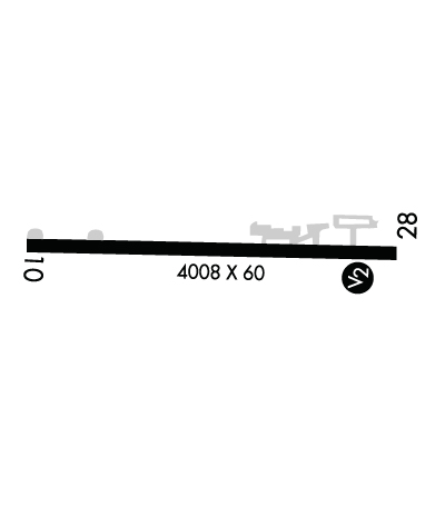
| Lat: N 4011.3 Long: W 07710.5 Elev: 510 Var: +10 Longest Runway: 4008 | ||
| CTAF: 122.8 | ||
| ||||||||||||||||||||||||||||||||||||||||||||
| ||||||||||||||||||||||||||||||||||||||||||||
| Rwy | Rwy | |||||||
| 4008x60 | 4008' | 4008x60 | 3882' | |||||
| Runway ID | Single Wheel | Double Wheel | Double Tandem Wheel | Dual Double Wheel |
| 10/28 | 12,500 | 12,500 | N/A | N/A |
| These numbers are Advisory and are not limits. The Airport Manager should have more accurate Weight Limits | ||||
 Airport Diagram might not be current. | |
| Facility Name: | CARLISLE |
| City Name: | CARLISLE |
| County: | CUMBERLAND |
| State abbrev: | PA |
| State Name: | PENNSYLVANIA |
| Ownership: | PUBLICLY OWNED |
| Use: | OPEN TO THE PUBLIC |
| Owner's Name: | SOUTH MIDDLETON TWP |
| Address: | 520 PARK DRIVE |
| BOILING SPRINGS, PA 17007 | |
| Owner's Phone: | 717-258-5324 |
| Manager's Name: | JEFF SMITH |
| Address: | 228 PETERSBURG RD |
| CARLISLE, PA 17013 | |
| Phone: | 717-448-7730 |
| FAA Region: | EASTERN |
| FAA Field Office: | HAR |
| Date | Sunrise | Sunset |
|---|---|---|
| 03/31/26 Tuesday | 6:55 | 19:32 |
| 04/01/26 Wednesday | 6:53 | 19:33 |
| 04/02/26 Thursday | 6:51 | 19:34 |
| 04/03/26 Friday | 6:50 | 19:35 |
| 04/04/26 Saturday | 6:48 | 19:36 |
| 04/05/26 Sunday | 6:47 | 19:37 |
| 04/06/26 Monday | 6:45 | 19:38 |
| 04/07/26 Tuesday | 6:43 | 19:39 |
| 04/08/26 Wednesday | 6:42 | 19:40 |
| 04/09/26 Thursday | 6:40 | 19:41 |
| 04/10/26 Friday | 6:39 | 19:42 |
| 04/11/26 Saturday | 6:37 | 19:43 |
| 04/12/26 Sunday | 6:36 | 19:44 |
| 04/13/26 Monday | 6:34 | 19:45 |
| Airport Attendance Schedule | MON-FRI 0700-1500, SAT-SUN IRREGULAR |
| Airport Status | OPERATIONAL (This Status can change at any time - please check NOTAMS) |
| Airport Lighting Schedule | ACTVT LIRL RWY 10/28 - CTAF. |
| Airport Storage Available | Tie Downs |
| Extra Services Available | NONE |
| Wind Indicator | YES - (lighted) |
| Control Tower | NO |
| CTAF Frequency | 122.800 |
| Unicom Frequency | 122.800 |
| Rotating Beacon Color | WG |
| Segmented Circle | YES |
| Landing Fee | NO |
| Airport Inspected | STATE - performed by STATE AERONAUTICAL PERSONNEL |
| Inspection Date | 10/22/2025 |
| Type of Fuel Available | Grade 100LL, JET A |
| Airframe Repair Service | MINOR |
| Power Plant Repair Service | MINOR |
| Latitude | N4011.3 |
| Longitude | W07710.5 (ESTIMATED) |
| Arpt Elevation | 510ft (SURVEYED) |
| Magnetic Variation | 10W |
| 2 miles SE | of CARLISLE |
| Traffic Pattern Altitude | |
| Sectional Chart | DETROIT |
| Operations (Reported) | Yearly | Avg. Daily |
|---|---|---|
| General Aviation Transient | 0 | 0 |
| General Aviation Local | 0 | 0 |
| Air Taxi | 0 | 0 |
| Commerical | 0 | 0 |
| Commuter | 0 | 0 |
| Military | 0 | 0 |
| Aircraft based on Field | |
|---|---|
| General Aviation Singles | 0 |
| General Aviation Multi | 0 |
| Jet Aircraft | 0 |
| General Aviation Helicopters | 0 |
| Military Aircraft | 0 |
| Gliders | 0 |
| Ultralights | 0 |
| FSS on field | NO |
| FSS tie-in | WILLIAMSPORT |
| FSS Phone | 1-800-WX-BRIEF |
| Who issues Notams | IPT |
| Notam D service at airport | YES |
| ARTCC Name | NEW YORK |
| Airport Certification | |
| Aircraft Rescue & Firefighting Index | None |
| Airport of Entry | No |
| Custom Landing Rights | No |
| Joint Civil/Military | No |
| Military Landing rights | No |
| DEER AND BIRDS ON & INVOF ARPT. LRG BIRD ACT INCREASED .5 NM W APCH END RWY 10. |
| DURG NGT OPS TRAILER PARK LGTS LCTD S OF RWY COULD BE MISTAKEN FOR RWY LGTS. |
| FOR CD CTC HARRISBURG APCH AT 800-932-0712. |
Airport Communications & Frequencies:
| ||||||||||||||
| Runway: 10 | Runway: 28 | ||
| Mag heading: | 102° | Mag heading: | 282° |
| Rwy Slope: | .19% Up | Rwy Slope: | -.19% Down |
| Approach: | Approach: | ||
| Pattern: | Left Traffic | Pattern: | Left Traffic |
| Markings: | NONPRECISION INSTRUMENT | Markings: | NONPRECISION INSTRUMENT |
| Marking Condition: | GOOD | Marking Condition: | GOOD |
| Arresting Dev: | Arresting Dev: | ||
| Lat & Long: | N4011.3 W07710.9 | Lat. & Long.: | N4011.3 W07710.0 |
| Elev: | 502.2 ft. MSL | Elev: | 509.9 ft. MSL |
| TCH: | TCH: | ||
| Visual Glide Path: | Visual Glide Path: | ||
| Displaced Threshold: | No | Displaced Threshold: | 126 feet |
| Touchdown Zone: | YES | Touchdown Zone: | YES |
| Touchdown Elev.: | 502.6 feet | Touchdown Elev.: | 508.3 feet |
| Visual Glide Slope: | Visual Glide Slope: | ||
| RVR Equipment: | RVR Equipment: | ||
| RVV Equipment: | NO | RVV Equipment: | NO |
| Approach Lights: | Approach Lights: | ||
| REIL: | NO | REIL: | NO |
| Centerline Lights: | NO | Centerline Lights: | NO |
| Touchdown lights: | NO | Touchdown lights: | NO |
| Runway Category: | Runway with a Visual Approach | Runway Category: | Runway with a Visual Approach |
| Declared Distances: | Declared Distances: | ||
| Comments: | Comments: | RWY 28 HAS 17 FT ROAD 185 FT FM RWY END ACRS CNTRLN. |
Thanks for using FltPlan.com
all rights reserved © 1999-2026 by Flight Plan LLC
