
| MINNEAPOLIS-ST. PAUL INTL. MINNEAPOLIS MN |
| |
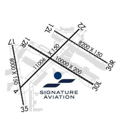
| Lat: N 4452.9 Long: W 09313.3 Elev: 842 Var: -00 Longest Runway: 11006 | ||
| Clr Del: 133.2 Dept. ATIS: 120.80 Arr. ATIS: 135.35 Ground: N121.8 S121.9 Tower: 123.95/126.7 | ||
| |||||||||||||||||||||||||||||||||||||||||||||||||||||||||||||||||||||
| |||||||||||||||||||||||||||||||||||||||||||||||||||||||||||||||||||||
| |||||||||||||||||||||||||||||||||||||||||||||||||||||||||||||||||||||
| |||||||||||||||||||||||||||||||||||||||||||||||||||||||||||||||||||||
| FBOs at nearby airports who want your business: | |||||||||||||||||
| |||||||||||||||||
| |||||||||||||||||
| Rwy | Rwy | |||||||
| 11006x150 | 9456' | 109.30 - 045° | 11006x150 | 10006' | 110.50 - 225° | |||
| 8200x150 | 8200' | 110.70 - 121° | 8200x150 | 8000' | 110.70 - 301° | |||
| 10000x200 | 10000' | 110.30 - 121° | 10000x200 | 10000' | 110.30 - 301° | |||
| 8000x150 | 8000' | 110.95 - 169° | 8000x150 | 8000' | 110.95 - 349° | |||
| Runway ID | Single Wheel | Double Wheel | Double Tandem Wheel | Dual Double Wheel |
| 04/22 | 100,000 | 200,000 | 400,000 | 850,000 |
| 12L/30R | 100,000 | 200,000 | 400,000 | 850,000 |
| 12R/30L | 100,000 | 200,000 | 400,000 | 850,000 |
| 17/35 | 100,000 | 200,000 | 400,000 | 850,000 |
| These numbers are Advisory and are not limits. The Airport Manager should have more accurate Weight Limits | ||||
 Airport Diagram might not be current. | |
| Facility Name: | MINNEAPOLIS-ST PAUL INTL/WOLD-CHAMBERLAIN |
| City Name: | MINNEAPOLIS |
| County: | HENNEPIN |
| State abbrev: | MN |
| State Name: | MINNESOTA |
| Ownership: | PUBLICLY OWNED |
| Use: | OPEN TO THE PUBLIC |
| Owner's Name: | METRO ARPT CMSN |
| Address: | 6040 28TH AVE SOUTH |
| MINNEAPOLIS, MN 55450 | |
| Owner's Phone: | 612-726-8100 |
| Manager's Name: | BRIAN RYKS |
| Address: | 6040 28TH AVE SOUTH |
| MINNEAPOLIS, MN 55450 | |
| Phone: | 612-726-8100 |
| FAA Region: | GREAT LAKES |
| FAA Field Office: | DMA |
| Date | Sunrise | Sunset |
|---|---|---|
| 09/24/21 Friday | 7:02 | 19:07 |
| 09/25/21 Saturday | 7:03 | 19:05 |
| 09/26/21 Sunday | 7:04 | 19:03 |
| 09/27/21 Monday | 7:06 | 19:01 |
| 09/28/21 Tuesday | 7:07 | 18:59 |
| 09/29/21 Wednesday | 7:08 | 18:58 |
| 09/30/21 Thursday | 7:09 | 18:56 |
| 10/01/21 Friday | 7:11 | 18:54 |
| 10/02/21 Saturday | 7:12 | 18:52 |
| 10/03/21 Sunday | 7:13 | 18:50 |
| 10/04/21 Monday | 7:14 | 18:48 |
| 10/05/21 Tuesday | 7:16 | 18:46 |
| 10/06/21 Wednesday | 7:17 | 18:45 |
| 10/07/21 Thursday | 7:18 | 18:43 |
| Airport Attendance Schedule | CONTINUOUS |
| Airport Status | OPERATIONAL (This Status can change at any time - please check NOTAMS) |
| Airport Lighting Schedule | |
| Airport Storage Available | Tie Downs, Hanger |
| Extra Services Available | Air Freight, Avionics, Cargo Handling, Charter |
| Wind Indicator | YES - (lighted) |
| Control Tower | YES |
| CTAF Frequency | |
| Unicom Frequency | 122.950 |
| Rotating Beacon Color | CLEAR-GREEN (Light Land Airport) |
| Segmented Circle | NO |
| Landing Fee | YES |
| Airport Inspected | FEDERAL - performed by FAA AIRPORTS FIELD PERSONNEL |
| Inspection Date | 07/19/2019 |
| Type of Fuel Available | Grade 100LL, JET A (freeze point -40C)A++; -10FUEL CIV RAMP A+; NC-100LL - 612-726-5700.; -A+FUEL MIL RAMP - MILOPS. |
| Airframe Repair Service | MAJOR |
| Power Plant Repair Service | MAJOR |
| Latitude | N4452.9 |
| Longitude | W09313.3 (ESTIMATED) |
| Arpt Elevation | 841ft (SURVEYED) |
| Magnetic Variation | 00E |
| 6 miles S | of MINNEAPOLIS |
| Traffic Pattern Altitude | |
| Sectional Chart | TWIN CITIES |
| Operations (Reported) | Yearly | Avg. Daily |
|---|---|---|
| General Aviation Transient | 10548 | 29 |
| General Aviation Local | 0 | 0 |
| Air Taxi | 15030 | 41 |
| Commerical | 218075 | 597 |
| Commuter | 0 | 0 |
| Military | 1174 | 3 |
| Aircraft based on Field | |
|---|---|
| General Aviation Singles | 0 |
| General Aviation Multi | 26 |
| Jet Aircraft | 136 |
| General Aviation Helicopters | 0 |
| Military Aircraft | 16 |
| Gliders | 0 |
| Ultralights | 0 |
| FSS on field | NO |
| FSS tie-in | PRINCETON |
| FSS Phone | 1-800-WX-BRIEF |
| Who issues Notams | MSP |
| Notam D service at airport | YES |
| ARTCC Name | MINNEAPOLIS |
| Airport Certification | AIRPORT RECEIVING SCHEDULED AIR CARRIER SERVICE FROM CARRIERS CERTIFICATED BY THE CIVIL AERONAUTICS BOARD |
| Aircraft Rescue & Firefighting Index | AIRPORT HAS A CERTIFICATE UNDER CFR PART 139 |
| Airport of Entry | No |
| Custom Landing Rights | YES |
| Joint Civil/Military | No |
| Military Landing rights | YES |
| NATIONAL PLAN OF INTEGRATED AIRPORT SYSTEMS (NPIAS) |
| GRANT AGREEMENTS UNDER FAAP/ADAP/AIP |
| SURPLUS PROPERTY AGREEMENT UNDER PUBLIC LAW 289 |
| SURPLUS PROPERTY AGREEMENT UNDER REGULATION 16-WAA |
| CONVEYANCE UNDER SCETION 16, FEDERAL AIRPORT ACT OF 1946 OR SECTION 23, AIRPORT AND AIRWAY DEVELOPMENT ACT OF 1970 |
| ASSURANCES PURSUANT TO TITLE VI, CIVIL RIGHTS ACT OF 1964 |
| TRNG FLTS PROHIBITED. GA FLTS MUST TRMT AT THE FBO OR US CUSTOMS UNLESS APVD BY AMGR. |
| 133 AW AFLD MGMT - 324.1 REMARKS: CALL LIGHTHOUSE. |
| COMMUNICATIONS: MINNEAPOLIS AIR RESERVE STATION JOINT COMD POST - 252.1 REMARKS: CALL NORTHSTAR. |
| 934 AW AFLD MGMT - PTD 282.675 REMARKS: CALL VIKING OPS. |
| REMARKS: AFRC 934 AW CTC PTD VIKING OPS 20 MIN PRIOR LDG. |
| ASDE-X IN USE; OPR TRANSPONDERS WITH ALT RPRT MODE & ADS-B ENABLED ON ALL ARPT SFCS. |
| UNSKED ACFT AT TRML 2-HUMPHREY REQ TO CTC TRML 2 GATE CONTROL ON 122.95 OR CALL 612-726-5742 PRIOR TO ARR. |
| NOISE ABATEMENT PROCEDURES - 612-726-9411. NO STAGE 1 CAT CIVIL ACFT. NIGHT HR 2230-0600. |
| ALL GROUP VI ACFT WITH WINGSPAN GREATER THAN 214 FT PPR REQ PRIOR TO ARR - CTC AIRSIDE OPS 612-726-5111. |
| RWY STATUS LGTS IN OPRN. |
| ALL GA ACFT WITH LESS THAN 20 PAX THAT NEED TO CLEAR US CUSTOMS SHOULD CTC SIGNATURE FLT SUPPORT 128.95 OR 612-726-5700 PRIOR TO ARR. |
| TWY J CLSD TO ACFT WINGSPAN MORE THAN 85.5 FT. |
| BIRDS ON & INVOF ARPT. |
| SIGNATURE FLIGHT SUPPORT 128.95 |
| MILITARY: ARFC 934 AW OPS 1300-0400Z++ MON-FRI; CLSD WKEND AND HOL. UNIT TRNG ASSEMBLY WKEND 1330-2200Z++. ALL TRANS ACFT MUST RECEIVE PPR 48 HR PRIOR TO ETA - CTC AIRFIELD MGMT. |
| MILITARY RSTD: NO HAZ CL/DIV1.1 OR 1.2 EXPLOSIVES PERMITTED. LOADING OR UNLOADING OF HAZ CL/DIV 1.3, 1.4, 1.5 0R 1.6 MUST BE APV BY ARPT DRCT PRIOR TO FLT. |
| RWY 04 AER COMPLEX; DEP CHECK COMPASS VERIFY CORRECT HDG. |
Airport Communications & Frequencies:
| ||||||||||||||||||||||||||||||||||||||||||||||||||||||||||||||
| Runway: 04 | Runway: 22 | ||
| Mag heading: | 45° | Mag heading: | 225° |
| Rwy Slope: | -.03% Down | Rwy Slope: | .03% Up |
| Approach: | ILS | Approach: | LOCALIZER |
| Pattern: | Left Traffic | Pattern: | Left Traffic |
| Markings: | PRECISION INSTRUMENT | Markings: | PRECISION INSTRUMENT |
| Marking Condition: | GOOD | Marking Condition: | GOOD |
| Arresting Dev: | Arresting Dev: | ||
| Lat & Long: | N4452.3 W09314.3 | Lat. & Long.: | N4453.6 W09312.5 |
| Elev: | 833.5 ft. MSL | Elev: | 830.3 ft. MSL |
| TCH: | 76 ft. AGL | TCH: | 61 ft. AGL |
| Visual Glide Path: | 3.00 degrees | Visual Glide Path: | 3.00 degrees |
| Displaced Threshold: | 1550 feet | Displaced Threshold: | 1000 feet |
| Touchdown Zone: | YES | Touchdown Zone: | YES |
| Touchdown Elev.: | 831.7 feet | Touchdown Elev.: | 828.3 feet |
| Visual Glide Slope: | 4-Light PAPI on LEFT side of Runway | Visual Glide Slope: | 4-Light PAPI on LEFT side of Runway |
| RVR Equipment: | TOUCHDOWN-ROLLOUT | RVR Equipment: | TOUCHDOWN-ROLLOUT |
| RVV Equipment: | NO | RVV Equipment: | NO |
| Approach Lights: | MALSR - 1,400 foot medium intensity approach lighting system with runway alignment indicator lights | Approach Lights: | MALSR - 1,400 foot medium intensity approach lighting system with runway alignment indicator lights |
| REIL: | NO | REIL: | NO |
| Centerline Lights: | NO | Centerline Lights: | NO |
| Touchdown lights: | NO | Touchdown lights: | NO |
| Runway Category: | D | Runway Category: | D |
| Declared Distances: | TORA:11006' TODA:11006' ASDA:11006' LDA:9456' | Declared Distances: | TORA:11006' TODA:11006' ASDA:11006' LDA:10006' |
| Obstructions: | TREE | Obstructions: | TREE |
| Marked: | NOT Marked/Lighted | Marked: | NOT Marked/Lighted |
| Clearance slope: | 26:1; APCH RATIO 43:1 FM DSPLCD THR; 102 FT TREE 4456 FT FM DSPLCD THR 834 FT L OF CNTRLN. | Clearance slope: | 17:1; APCH RATIO 34:1 FM DSPLCD THR; 68 FT TREE 2337 FT FM DSPLCD THR. |
| Obstruction height: | 101 feet AGL | Obstruction height: | 66 feet AGL |
| Dist. from runway: | 2906 feet | Dist. from runway: | 1350 feet |
| Centerline offset: | 834 left of centerline | Centerline offset: | 636 feet right of centerline |
| Comments: | Comments: | 4 FT FENCE 500 FT R OF CNTRLN. |
| Runway: 12L | Runway: 30R | ||
| Mag heading: | 121° | Mag heading: | 301° |
| Rwy Slope: | -.23% Down | Rwy Slope: | .23% Up |
| Approach: | ILS/DME | Approach: | ILS/DME |
| Pattern: | Left Traffic | Pattern: | Left Traffic |
| Markings: | PRECISION INSTRUMENT | Markings: | PRECISION INSTRUMENT |
| Marking Condition: | GOOD | Marking Condition: | GOOD |
| Arresting Dev: | Arresting Dev: | ||
| Lat & Long: | N4453.6 W09313.3 | Lat. & Long.: | N4452.9 W09311.6 |
| Elev: | 838.6 ft. MSL | Elev: | 819.5 ft. MSL |
| TCH: | 79 ft. AGL | TCH: | 71 ft. AGL |
| Visual Glide Path: | 3.00 degrees | Visual Glide Path: | 3.00 degrees |
| Displaced Threshold: | No | Displaced Threshold: | 200 feet |
| Touchdown Zone: | YES | Touchdown Zone: | YES |
| Touchdown Elev.: | 840.7 feet | Touchdown Elev.: | 822.4 feet |
| Visual Glide Slope: | 4-Light PAPI on LEFT side of Runway | Visual Glide Slope: | 4-Light PAPI on LEFT side of Runway |
| RVR Equipment: | TOUCHDOWN-MIDFIELD-ROLLOUT | RVR Equipment: | TOUCHDOWN-MIDFIELD-ROLLOUT |
| RVV Equipment: | NO | RVV Equipment: | NO |
| Approach Lights: | ALSF2 - standard 2,400 foot high intensity approach lighting system with sequenced flashers, Category II or III | Approach Lights: | MALSF - 1,400 foot medium intensity approach lighting system with sequenced flashers |
| REIL: | NO | REIL: | NO |
| Centerline Lights: | YES | Centerline Lights: | YES |
| Touchdown lights: | YES | Touchdown lights: | NO |
| Runway Category: | Precision Instrument Runway | Runway Category: | Precision Instrument Runway |
| Declared Distances: | TORA:8200' TODA:8200' ASDA:7620' LDA:7620' | Declared Distances: | TORA:8200' TODA:8200' ASDA:8200' LDA:8000' |
| Obstructions: | TREE | Obstructions: | TREE |
| Marked: | NOT Marked/Lighted | Marked: | NOT Marked/Lighted |
| Clearance slope: | 46:1 | Clearance slope: | 46:1 |
| Obstruction height: | 61 feet AGL | Obstruction height: | 13 feet AGL |
| Dist. from runway: | 3011 feet | Dist. from runway: | 808 feet |
| Centerline offset: | 667 right of centerline | Centerline offset: | 272 feet right of centerline |
| Comments: | Comments: |
| Runway: 12R | Runway: 30L | ||
| Mag heading: | 121° | Mag heading: | 301° |
| Rwy Slope: | -.27% Down | Rwy Slope: | .27% Up |
| Approach: | ILS/DME | Approach: | ILS/DME |
| Pattern: | Left Traffic | Pattern: | Left Traffic |
| Markings: | PRECISION INSTRUMENT | Markings: | PRECISION INSTRUMENT |
| Marking Condition: | GOOD | Marking Condition: | GOOD |
| Arresting Dev: | EMAS; ENGINEERED MATERIALS ARRESTING SYSTEM (EMAS) 160 FT IN LENGTH BY 216 FT IN WIDTH LCTD AT DER 12R. | Arresting Dev: | |
| Lat & Long: | N4453.3 W09314.0 | Lat. & Long.: | N4452.4 W09312.1 |
| Elev: | 841.8 ft. MSL | Elev: | 814.4 ft. MSL |
| TCH: | 66 ft. AGL | TCH: | 78 ft. AGL |
| Visual Glide Path: | 3.00 degrees | Visual Glide Path: | 3.00 degrees |
| Displaced Threshold: | No | Displaced Threshold: | No |
| Touchdown Zone: | YES | Touchdown Zone: | YES |
| Touchdown Elev.: | 841.8 feet | Touchdown Elev.: | 823.0 feet |
| Visual Glide Slope: | 4-Light PAPI on LEFT side of Runway | Visual Glide Slope: | 4-Light PAPI on LEFT side of Runway |
| RVR Equipment: | TOUCHDOWN-MIDFIELD-ROLLOUT | RVR Equipment: | TOUCHDOWN-MIDFIELD-ROLLOUT |
| RVV Equipment: | NO | RVV Equipment: | NO |
| Approach Lights: | ALSF2 - standard 2,400 foot high intensity approach lighting system with sequenced flashers, Category II or III | Approach Lights: | ALSF2 - standard 2,400 foot high intensity approach lighting system with sequenced flashers, Category II or III |
| REIL: | NO | REIL: | NO |
| Centerline Lights: | YES | Centerline Lights: | YES |
| Touchdown lights: | YES | Touchdown lights: | YES |
| Runway Category: | Precision Instrument Runway | Runway Category: | Precision Instrument Runway |
| Declared Distances: | TORA:10000' TODA:10000' ASDA:10000' LDA:10000' | Declared Distances: | TORA:10000' TODA:10000' ASDA:10000' LDA:10000' |
| Obstructions: | Obstructions: | TREE | |
| Marked: | Marked: | LIGHTED | |
| Clearance slope: | 50:1 | Clearance slope: | 35:1 |
| Obstruction height: | Obstruction height: | 36 feet AGL | |
| Dist. from runway: | Dist. from runway: | 1477 feet | |
| Centerline offset: | Centerline offset: | 562 feet right of centerline | |
| Comments: | Comments: |
| Runway: 17 | Runway: 35 | ||
| Mag heading: | 170° | Mag heading: | 350° |
| Rwy Slope: | -.09% Down | Rwy Slope: | .09% Up |
| Approach: | LOC/DME | Approach: | ILS/DME |
| Pattern: | Left Traffic | Pattern: | Left Traffic |
| Markings: | NONPRECISION INSTRUMENT | Markings: | PRECISION INSTRUMENT |
| Marking Condition: | GOOD | Marking Condition: | GOOD |
| Arresting Dev: | Arresting Dev: | ||
| Lat & Long: | N4453.3 W09314.5 | Lat. & Long.: | N4452.0 W09314.2 |
| Elev: | 840.4 ft. MSL | Elev: | 833.3 ft. MSL |
| TCH: | 60 ft. AGL | TCH: | 71 ft. AGL |
| Visual Glide Path: | 3.00 degrees | Visual Glide Path: | 3.00 degrees |
| Displaced Threshold: | No | Displaced Threshold: | No |
| Touchdown Zone: | YES | Touchdown Zone: | YES |
| Touchdown Elev.: | 840.4 feet | Touchdown Elev.: | 834.4 feet |
| Visual Glide Slope: | 4-Light PAPI on RIGHT side of Runway | Visual Glide Slope: | 4-Light PAPI on LEFT side of Runway |
| RVR Equipment: | TOUCHDOWN-MIDFIELD-ROLLOUT | RVR Equipment: | TOUCHDOWN-MIDFIELD-ROLLOUT |
| RVV Equipment: | NO | RVV Equipment: | NO |
| Approach Lights: | Approach Lights: | ALSF2 - standard 2,400 foot high intensity approach lighting system with sequenced flashers, Category II or III | |
| REIL: | YES | REIL: | NO |
| Centerline Lights: | YES | Centerline Lights: | YES |
| Touchdown lights: | NO | Touchdown lights: | YES |
| Runway Category: | Runway with a Non-precision Approach having visibility minimums greater than 3/4 mile | Runway Category: | Precision Instrument Runway |
| Declared Distances: | TORA:8000' TODA:8000' ASDA:8000' LDA:8000' | Declared Distances: | TORA:8000' TODA:8000' ASDA:8000' LDA:8000' |
| Obstructions: | TREE | Obstructions: | |
| Marked: | NOT Marked/Lighted | Marked: | |
| Clearance slope: | 34:1 | Clearance slope: | 50:1 |
| Obstruction height: | 52 feet AGL | Obstruction height: | |
| Dist. from runway: | 1990 feet | Dist. from runway: | |
| Centerline offset: | 732 right of centerline | Centerline offset: | |
| Comments: | Comments: |
Thanks for using FltPlan.com
all rights reserved © 1999-2021 by Flight Plan LLC