
| LONG ISLAND MAC ARTHUR NEW YORK NY |
| |
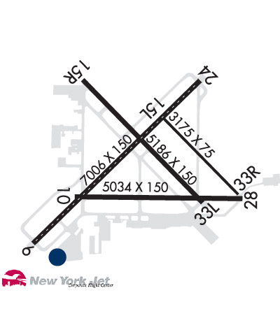
| Lat: N 4047.8 Long: W 07306.0 Elev: 99 Var: +14 Longest Runway: 7006 | ||
| Clr Del: 121.85 Dept. ATIS: 120.72 Arr. ATIS: 120.72 Ground: 135.3 Tower: 119.3/124.3 | ||
| ||||||||||||||||||||||||||||||||||||||||||||||||||||||||||||||||||||
| ||||||||||||||||||||||||||||||||||||||||||||||||||||||||||||||||||||
| ||||||||||||||||||||||||||||||||||||||||||||||||||||||||||||||||||||
| ||||||||||||||||||||||||||||||||||||||||||||||||||||||||||||||||||||
| Rwy | Rwy | |||||||
| 7006x150 | 7006' | 108.30 - 058° | 7006x150 | 7006' | 108.30 - 239° | |||
| 3175x75 | 3175' | 3175x75 | 3175' | |||||
| 5186x150 | 5186' | 5186x150 | 5186' | |||||
| Runway ID | Single Wheel | Double Wheel | Double Tandem Wheel | Dual Double Wheel |
| 06/24 | 100,000 | 210,000 | 300,000 | N/A |
| 15L/33R | 25,000 | N/A | N/A | N/A |
| 15R/33L | 100,000 | 170,000 | 300,000 | N/A |
| H1 | N/A | N/A | N/A | N/A |
| H2 | N/A | N/A | N/A | N/A |
| These numbers are Advisory and are not limits. The Airport Manager should have more accurate Weight Limits | ||||
 Airport Diagram might not be current. | |
| Facility Name: | LONG ISLAND MAC ARTHUR |
| City Name: | NEW YORK |
| County: | SUFFOLK |
| State abbrev: | NY |
| State Name: | NEW YORK |
| Ownership: | PUBLICLY OWNED |
| Use: | OPEN TO THE PUBLIC |
| Owner's Name: | TOWN OF ISLIP |
| Address: | 655 MAIN ST |
| ISLIP, NY 11751 | |
| Owner's Phone: | 631-467-3300 |
| Manager's Name: | ROBERT A. SCHNEIDER |
| Address: | 100 ARRIVAL AVE |
| RONKONKOMA, NY 11779-7398 | |
| Phone: | 631-467-3300 |
| FAA Region: | EASTERN |
| FAA Field Office: | NYC |
| Date | Sunrise | Sunset |
|---|---|---|
| 12/05/25 Friday | 7:01 | 16:25 |
| 12/06/25 Saturday | 7:02 | 16:25 |
| 12/07/25 Sunday | 7:03 | 16:25 |
| 12/08/25 Monday | 7:04 | 16:25 |
| 12/09/25 Tuesday | 7:05 | 16:25 |
| 12/10/25 Wednesday | 7:06 | 16:25 |
| 12/11/25 Thursday | 7:06 | 16:25 |
| 12/12/25 Friday | 7:07 | 16:25 |
| 12/13/25 Saturday | 7:08 | 16:25 |
| 12/14/25 Sunday | 7:09 | 16:25 |
| 12/15/25 Monday | 7:09 | 16:26 |
| 12/16/25 Tuesday | 7:10 | 16:26 |
| 12/17/25 Wednesday | 7:11 | 16:26 |
| 12/18/25 Thursday | 7:11 | 16:27 |
| Airport Attendance Schedule | CONTINUOUS |
| Airport Status | OPERATIONAL (This Status can change at any time - please check NOTAMS) |
| Airport Lighting Schedule | DUSK TO DAWN. WHEN ATCT CLSD ACTVT MIRL RWY 15R/33L; TWY LGTS- CTAF. HIRL RWY 06/24 PRESET LOW INTST ACTVT - CTAF; MALSR RWY 06 & 24 PRESET MED INTST FOR PREVAILING WIND RWY. |
| Airport Storage Available | Tie Downs, Hanger |
| Extra Services Available | Air Freight, Charter, Flight Instruction, Aircraft Rental, Aircraft Sales |
| Wind Indicator | YES - (unlit) |
| Control Tower | YES |
| CTAF Frequency | 119.300 |
| Unicom Frequency | 122.950 |
| Rotating Beacon Color | WG |
| Segmented Circle | YES |
| Landing Fee | YES; LDG FEE FOR ALL ACFT EXC MIL AND GOVT. |
| Airport Inspected | FEDERAL - performed by FAA AIRPORTS FIELD PERSONNEL |
| Inspection Date | 07/09/2025 |
| Type of Fuel Available | Grade 100LL, JET A (freeze point -40C) |
| Airframe Repair Service | MAJOR |
| Power Plant Repair Service | MAJOR |
| Latitude | N4047.8 |
| Longitude | W07306.0 (ESTIMATED) |
| Arpt Elevation | 98ft (SURVEYED) |
| Magnetic Variation | 14W |
| 40 miles E | of NEW YORK |
| Traffic Pattern Altitude | |
| Sectional Chart | NEW YORK |
| Operations (Reported) | Yearly | Avg. Daily |
|---|---|---|
| General Aviation Transient | 0 | 0 |
| General Aviation Local | 0 | 0 |
| Air Taxi | 0 | 0 |
| Commerical | 0 | 0 |
| Commuter | 0 | 0 |
| Military | 0 | 0 |
| Aircraft based on Field | |
|---|---|
| General Aviation Singles | 0 |
| General Aviation Multi | 0 |
| Jet Aircraft | 0 |
| General Aviation Helicopters | 0 |
| Military Aircraft | 0 |
| Gliders | 0 |
| Ultralights | 0 |
| FSS on field | NO |
| FSS tie-in | NEW YORK |
| FSS Phone | 1-800-WX-BRIEF |
| Who issues Notams | ISP |
| Notam D service at airport | YES |
| ARTCC Name | NEW YORK |
| Airport Certification | AIRPORT RECEIVING SCHEDULED AIR CARRIER SERVICE FROM CARRIERS CERTIFICATED BY THE CIVIL AERONAUTICS BOARD |
| Aircraft Rescue & Firefighting Index | AIRPORT HAS A CERTIFICATE UNDER CFR PART 139 |
| Airport of Entry | No |
| Custom Landing Rights | YES; LDG FEE FOR ALL ACFT EXC MIL, GOVT AND NOT-FOR-PROFIT MEDICAL FLIGHTS. |
| Joint Civil/Military | No |
| Military Landing rights | YES |
| NATIONAL PLAN OF INTEGRATED AIRPORT SYSTEMS (NPIAS) |
| GRANT AGREEMENTS UNDER FAAP/ADAP/AIP |
| ASSURANCES PURSUANT TO TITLE VI, CIVIL RIGHTS ACT OF 1964 |
| ADZY:TFC LNDG RWY 33L HIGH DENSITY VFR TFC OPERG 600 FT MSL & BLW VCNTY BAYPORT AERODROME 3 MILES SE. |
| FOR CD WHEN ATCT CLSD CTC NEW YORK APCH AT 516-683-2449. |
| BIRD ACTVTY ON & INVOF ARPT. |
| TWY S UNLGTD EAST OF TRML APN. |
| RWY 15L/33R CLSD TO FIXED WING ACFT AT NGT & AVBL FOR TXG. |
| UPDRAFTS MAY BE ENCOUNTERED INVOF POWER PLANT 1.5 NM NE RWY 24. |
| RWY 15L/33R NOT AVBL FOR NIGHT TKOF AND LDG OPS. LIMITED TO ACFT 48,000 LBS OR LESS. |
| VOLUNTARY NS ABTMT PROCEDURES IN EFFECT FOR FIXED WING ACFT AND HELICOPTERS. CTC AIRPORT MANAGEMENT (631)467-3300. |
| RWY 15L/ 33RRWY 15L/33R NOT AVBL FOR PART 121/PART 380 OPS WITH SKED PAX CARRYING OPS MORE THAN 9 PAX SEATS AND NON-SKED PAX CARRYING OPS MORE THAN 30 PAX SEATS. |
| RWY H1 LCTD ON TWY W SOUTH OF INT OF TWY B. |
| RWY H2 LCTD ON TWY C NORTH OF TWY S. |
| RWY 06/2 4 PCR VALUE: 550/F/A/X/T |
| RWY 15L/ 33RPCR VALUE: 280/F/B/X/T |
| RWY 15R/ 33LPCR VALUE: 590/F/B/X/T |
Airport Communications & Frequencies:
| |||||||||||||||||||||||||||||||||||||||||||
| Runway: 06 | Runway: 24 | ||
| Mag heading: | 59° | Mag heading: | 239° |
| Rwy Slope: | .09% Up | Rwy Slope: | -.09% Down |
| Approach: | ILS/DME | Approach: | ILS/DME |
| Pattern: | Left Traffic | Pattern: | Right Traffic |
| Markings: | PRECISION INSTRUMENT | Markings: | PRECISION INSTRUMENT |
| Marking Condition: | GOOD | Marking Condition: | GOOD |
| Arresting Dev: | Arresting Dev: | ||
| Lat & Long: | N4047.3 W07306.7 | Lat. & Long.: | N4048.1 W07305.7 |
| Elev: | 92.3 ft. MSL | Elev: | 98.7 ft. MSL |
| TCH: | 53 ft. AGL | TCH: | 52 ft. AGL |
| Visual Glide Path: | 3.00 degrees | Visual Glide Path: | 3.00 degrees |
| Displaced Threshold: | No | Displaced Threshold: | No |
| Touchdown Zone: | YES | Touchdown Zone: | YES |
| Touchdown Elev.: | 93.9 feet | Touchdown Elev.: | 98.7 feet |
| Visual Glide Slope: | 4-Light PAPI on LEFT side of Runway | Visual Glide Slope: | 4-Light PAPI on LEFT side of Runway |
| RVR Equipment: | TOUCHDOWN-ROLLOUT | RVR Equipment: | TOUCHDOWN-ROLLOUT |
| RVV Equipment: | NO | RVV Equipment: | NO |
| Approach Lights: | MALSR - 1,400 foot medium intensity approach lighting system with runway alignment indicator lights; NSTD MALSR; THREE OUTERMOST FLASHER LGTS EXCEED STD SPACING. | Approach Lights: | MALSR - 1,400 foot medium intensity approach lighting system with runway alignment indicator lights |
| REIL: | NO | REIL: | NO |
| Centerline Lights: | YES | Centerline Lights: | YES |
| Touchdown lights: | NO | Touchdown lights: | NO |
| Runway Category: | Precision Instrument Runway | Runway Category: | Precision Instrument Runway |
| Declared Distances: | TORA:7006' TODA:7006' ASDA:7006' LDA:7006' | Declared Distances: | TORA:7006' TODA:7006' ASDA:7006' LDA:7006' |
| Obstructions: | TREE | Obstructions: | |
| Marked: | NOT Marked/Lighted | Marked: | |
| Clearance slope: | 30:1 | Clearance slope: | 50:1 |
| Obstruction height: | 38 feet AGL | Obstruction height: | |
| Dist. from runway: | 1340 feet | Dist. from runway: | |
| Centerline offset: | 350 left of centerline | Centerline offset: | |
| Comments: | Comments: |
| Runway: 15L | Runway: 33R | ||
| Mag heading: | 149° | Mag heading: | 329° |
| Rwy Slope: | -.31% Down | Rwy Slope: | .31% Up |
| Approach: | Approach: | ||
| Pattern: | Left Traffic | Pattern: | Right Traffic |
| Markings: | NONSTANDARD | Markings: | NONSTANDARD |
| Marking Condition: | GOOD; NSTD MKGS, THR BAR MISG ON RWY END. | Marking Condition: | GOOD; NSTD MKGS, THR BAR MISG ON RWY END. |
| Arresting Dev: | Arresting Dev: | ||
| Lat & Long: | N4047.9 W07305.9 | Lat. & Long.: | N4047.6 W07305.4 |
| Elev: | 91.2 ft. MSL | Elev: | 81.4 ft. MSL |
| TCH: | TCH: | ||
| Visual Glide Path: | Visual Glide Path: | ||
| Displaced Threshold: | No | Displaced Threshold: | No |
| Touchdown Zone: | YES | Touchdown Zone: | YES |
| Touchdown Elev.: | 91.2 feet | Touchdown Elev.: | 90.5 feet |
| Visual Glide Slope: | Visual Glide Slope: | ||
| RVR Equipment: | RVR Equipment: | ||
| RVV Equipment: | NO | RVV Equipment: | NO |
| Approach Lights: | Approach Lights: | ||
| REIL: | NO | REIL: | NO |
| Centerline Lights: | NO | Centerline Lights: | NO |
| Touchdown lights: | NO | Touchdown lights: | NO |
| Runway Category: | Runway with a Visual Approach | Runway Category: | Runway with a Visual Approach |
| Declared Distances: | TORA:3175' TODA:3175' ASDA:3175' LDA:3175' | Declared Distances: | TORA:3175' TODA:3175' ASDA:3175' LDA:3175' |
| Runway: 15R | Runway: 33L | ||
| Mag heading: | 149° | Mag heading: | 329° |
| Rwy Slope: | -.39% Down | Rwy Slope: | .39% Up |
| Approach: | Approach: | ||
| Pattern: | Right Traffic | Pattern: | Left Traffic |
| Markings: | NONPRECISION INSTRUMENT | Markings: | NONPRECISION INSTRUMENT |
| Marking Condition: | GOOD | Marking Condition: | GOOD |
| Arresting Dev: | Arresting Dev: | ||
| Lat & Long: | N4048.1 W07306.4 | Lat. & Long.: | N4047.5 W07305.6 |
| Elev: | 98.5 ft. MSL | Elev: | 78.5 ft. MSL |
| TCH: | 46 ft. AGL | TCH: | 50 ft. AGL |
| Visual Glide Path: | 3.10 degrees | Visual Glide Path: | 3.00 degrees |
| Displaced Threshold: | No | Displaced Threshold: | No |
| Touchdown Zone: | YES | Touchdown Zone: | YES |
| Touchdown Elev.: | 98.6 feet | Touchdown Elev.: | 89.4 feet |
| Visual Glide Slope: | 4-Light PAPI on LEFT side of Runway | Visual Glide Slope: | 4-Light PAPI on LEFT side of Runway |
| RVR Equipment: | RVR Equipment: | ||
| RVV Equipment: | NO | RVV Equipment: | NO |
| Approach Lights: | Approach Lights: | ||
| REIL: | NO | REIL: | NO |
| Centerline Lights: | NO | Centerline Lights: | NO |
| Touchdown lights: | NO | Touchdown lights: | NO |
| Runway Category: | Runway with a Non-precision Approach having visibility minimums greater than 3/4 mile | Runway Category: | Runway with a Non-precision Approach having visibility minimums greater than 3/4 mile |
| Declared Distances: | TORA:5186' TODA:5186' ASDA:5186' LDA:5186' | Declared Distances: | TORA:5186' TODA:5186' ASDA:5186' LDA:5186' |
| Obstructions: | Obstructions: | TREES | |
| Marked: | Marked: | NOT Marked/Lighted | |
| Clearance slope: | 34:1 | Clearance slope: | 28:1 |
| Obstruction height: | Obstruction height: | 39 feet AGL | |
| Dist. from runway: | Dist. from runway: | 1300 feet | |
| Centerline offset: | Centerline offset: | 300 feet right of centerline | |
| Comments: | Comments: |
Thanks for using FltPlan.com
all rights reserved © 1999-2025 by Flight Plan LLC