
| ALBANY INTL ALBANY NY |
| |
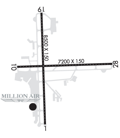
| Lat: N 4244.9 Long: W 07348.1 Elev: 285 Var: +13 Longest Runway: 8500 | ||
| Clr Del: 127.5 Dept. ATIS: 120.45 Arr. ATIS: 120.45 Ground: 121.7 Tower: 119.5 | ||
| ||||||||||||||||||||||||||||||||||||||||||||
| ||||||||||||||||||||||||||||||||||||||||||||
| ||||||||||||||||||||||||||||||||||||||||||||
| ||||||||||||||||||||||||||||||||||||||||||||
| Rwy | Rwy | |||||||
| 8500x150 | 8500' | 109.50 - 011° | 8500x150 | 8500' | 109.50 - 191° | |||
| 7200x150 | 7200' | 7200x150 | 6008' | |||||
| Runway ID | Single Wheel | Double Wheel | Double Tandem Wheel | Dual Double Wheel |
| 01/19 | 140,000 | 200,000 | 400,000 | N/A |
| 10/28 | 140,000 | 200,000 | 400,000 | N/A |
| These numbers are Advisory and are not limits. The Airport Manager should have more accurate Weight Limits | ||||
 Airport Diagram might not be current. | |
| Facility Name: | ALBANY INTL |
| City Name: | ALBANY |
| County: | ALBANY |
| State abbrev: | NY |
| State Name: | NEW YORK |
| Ownership: | PUBLICLY OWNED |
| Use: | OPEN TO THE PUBLIC |
| Owner's Name: | ALBANY COUNTY ARPT AUTH; LEASEE. PROPERTY OWNED BY ALBANY CO, 112 STATE ST, ALBANY, NY 12207; FONE 518-447-7000. |
| Address: | 737 ALBANY SHAKER RD |
| ALBANY, NY 12211 | |
| Owner's Phone: | 518-242-2200 |
| Manager's Name: | TODD PENNINGTON |
| Address: | 737 ALBANY SHAKER RD |
| ALBANY, NY 12211 | |
| Phone: | 518-242-2352 |
| FAA Region: | EASTERN |
| FAA Field Office: | NYC |
| Date | Sunrise | Sunset |
|---|---|---|
| 08/08/25 Friday | 5:54 | 20:07 |
| 08/09/25 Saturday | 5:55 | 20:06 |
| 08/10/25 Sunday | 5:56 | 20:05 |
| 08/11/25 Monday | 5:57 | 20:03 |
| 08/12/25 Tuesday | 5:58 | 20:02 |
| 08/13/25 Wednesday | 5:59 | 20:00 |
| 08/14/25 Thursday | 6:00 | 19:59 |
| 08/15/25 Friday | 6:01 | 19:57 |
| 08/16/25 Saturday | 6:02 | 19:56 |
| 08/17/25 Sunday | 6:03 | 19:54 |
| 08/18/25 Monday | 6:04 | 19:53 |
| 08/19/25 Tuesday | 6:06 | 19:51 |
| 08/20/25 Wednesday | 6:07 | 19:50 |
| 08/21/25 Thursday | 6:08 | 19:48 |
| Airport Attendance Schedule | CONTINUOUS |
| Airport Status | OPERATIONAL (This Status can change at any time - please check NOTAMS) |
| Airport Lighting Schedule | SS-SR |
| Airport Storage Available | Tie Downs, Hanger |
| Extra Services Available | Cargo Handling, Flight Instruction, Aircraft Rental, Aircraft Sales, Annual Surveying |
| Wind Indicator | YES - (lighted) |
| Control Tower | YES |
| CTAF Frequency | |
| Unicom Frequency | 122.950 |
| Rotating Beacon Color | WG |
| Segmented Circle | NO |
| Landing Fee | YES |
| Airport Inspected | FEDERAL - performed by FAA AIRPORTS FIELD PERSONNEL |
| Inspection Date | 01/28/2025 |
| Type of Fuel Available | Grade 100LL, JET A (freeze point -40C) |
| Airframe Repair Service | MAJOR |
| Power Plant Repair Service | MAJOR |
| Latitude | N4244.9 |
| Longitude | W07348.1 (ESTIMATED) |
| Arpt Elevation | 284ft (SURVEYED) |
| Magnetic Variation | 13W |
| 6 miles NW | of ALBANY |
| Traffic Pattern Altitude | |
| Sectional Chart | NEW YORK |
| Operations (Reported) | Yearly | Avg. Daily |
|---|---|---|
| General Aviation Transient | 0 | 0 |
| General Aviation Local | 0 | 0 |
| Air Taxi | 0 | 0 |
| Commerical | 0 | 0 |
| Commuter | 0 | 0 |
| Military | 0 | 0 |
| Aircraft based on Field | |
|---|---|
| General Aviation Singles | 0 |
| General Aviation Multi | 0 |
| Jet Aircraft | 0 |
| General Aviation Helicopters | 0 |
| Military Aircraft | 0 |
| Gliders | 0 |
| Ultralights | 0 |
| FSS on field | NO |
| FSS tie-in | BURLINGTON |
| FSS Phone | 1-800-WX-BRIEF |
| Who issues Notams | ALB |
| Notam D service at airport | YES |
| ARTCC Name | BOSTON |
| Airport Certification | AIRPORT RECEIVING SCHEDULED AIR CARRIER SERVICE FROM CARRIERS CERTIFICATED BY THE CIVIL AERONAUTICS BOARD |
| Aircraft Rescue & Firefighting Index | AIRPORT HAS A CERTIFICATE UNDER CFR PART 139 |
| Airport of Entry | YES |
| Custom Landing Rights | No |
| Joint Civil/Military | No |
| Military Landing rights | YES |
| NATIONAL PLAN OF INTEGRATED AIRPORT SYSTEMS (NPIAS) |
| GRANT AGREEMENTS UNDER FAAP/ADAP/AIP |
| ASSURANCES PURSUANT TO TITLE VI, CIVIL RIGHTS ACT OF 1964 |
| MOWING WI SAFETY AREAS OF ALL RWYS & TWYS MAY-NOV. |
| NO ACFT PRKG BTN FIRE STN & TWY L. |
| TWY D EAST OF RWY 01/19 RSTRD TO ACFT 12500 LBS & LESS. |
| BIRDS, DEER & OTHER WILDLIFE ON & INVOF ARPT. |
| WX BALLOON LAUNCHES APRXLY 3 MI S OF ARPT AT 0600 & 1800. |
| TWY C WEST OF TWY A: NON MOV AREA. |
| CUST/IMG FLT INFO SVC FAC LCTD N END GA APN. ACFT CLRG CUST USE PAINTED PSN MKGS & PROCD TO MINIMIZE BLAST IMPACT. |
| RWY 01/1 9 PCR VALUE: 508/F/D/X/T |
| RWY 10/2 8 PCR VALUE: 266/F/D/X/T |
Airport Communications & Frequencies:
| ||||||||||||||||||||||||||||||||||||||||||||||||||||
| Runway: 01 | Runway: 19 | ||
| Mag heading: | 11° | Mag heading: | 191° |
| Rwy Slope: | -.06% Down | Rwy Slope: | .06% Up |
| Approach: | ILS/DME | Approach: | ILS/DME |
| Pattern: | Left Traffic | Pattern: | Left Traffic |
| Markings: | PRECISION INSTRUMENT | Markings: | PRECISION INSTRUMENT |
| Marking Condition: | GOOD | Marking Condition: | GOOD |
| Arresting Dev: | Arresting Dev: | ||
| Lat & Long: | N4244.2 W07348.3 | Lat. & Long.: | N4245.6 W07348.3 |
| Elev: | 284.3 ft. MSL | Elev: | 279.4 ft. MSL |
| TCH: | 53 ft. AGL | TCH: | 53 ft. AGL |
| Visual Glide Path: | 3.00 degrees | Visual Glide Path: | 3.00 degrees |
| Displaced Threshold: | No | Displaced Threshold: | No |
| Touchdown Zone: | YES | Touchdown Zone: | YES |
| Touchdown Elev.: | 284.3 feet | Touchdown Elev.: | 279.5 feet |
| Visual Glide Slope: | 4-Light PAPI on RIGHT side of Runway | Visual Glide Slope: | 4-Light PAPI on LEFT side of Runway |
| RVR Equipment: | TOUCHDOWN-ROLLOUT | RVR Equipment: | TOUCHDOWN-ROLLOUT |
| RVV Equipment: | NO | RVV Equipment: | YES |
| Approach Lights: | MALSR - 1,400 foot medium intensity approach lighting system with runway alignment indicator lights | Approach Lights: | MALSR - 1,400 foot medium intensity approach lighting system with runway alignment indicator lights |
| REIL: | NO | REIL: | NO |
| Centerline Lights: | YES | Centerline Lights: | YES |
| Touchdown lights: | YES | Touchdown lights: | NO |
| Runway Category: | Precision Instrument Runway | Runway Category: | Precision Instrument Runway |
| Declared Distances: | TORA:8500' TODA:8500' ASDA:8500' LDA:8500' | Declared Distances: | TORA:8500' TODA:8500' ASDA:8500' LDA:8500' |
| Obstructions: | Obstructions: | TREE | |
| Marked: | Marked: | NOT Marked/Lighted | |
| Clearance slope: | 50:1 | Clearance slope: | 23:1 |
| Obstruction height: | Obstruction height: | 80 feet AGL | |
| Dist. from runway: | Dist. from runway: | 2040 feet | |
| Centerline offset: | Centerline offset: | 75 feet left of centerline | |
| Comments: | Comments: |
| Runway: 10 | Runway: 28 | ||
| Mag heading: | 101° | Mag heading: | 281° |
| Rwy Slope: | -.01% Down | Rwy Slope: | .01% Up |
| Approach: | Approach: | ||
| Pattern: | Left Traffic | Pattern: | Left Traffic |
| Markings: | NONPRECISION INSTRUMENT | Markings: | NONPRECISION INSTRUMENT |
| Marking Condition: | GOOD | Marking Condition: | GOOD |
| Arresting Dev: | Arresting Dev: | ||
| Lat & Long: | N4244.9 W07348.7 | Lat. & Long.: | N4245.0 W07347.1 |
| Elev: | 276.4 ft. MSL | Elev: | 276.0 ft. MSL |
| TCH: | TCH: | 53 ft. AGL | |
| Visual Glide Path: | Visual Glide Path: | 3.22 degrees | |
| Displaced Threshold: | No | Displaced Threshold: | 1192 feet |
| Touchdown Zone: | YES | Touchdown Zone: | YES |
| Touchdown Elev.: | 278.3 feet | Touchdown Elev.: | 284.8 feet |
| Visual Glide Slope: | Visual Glide Slope: | 4-Light PAPI on LEFT side of Runway | |
| RVR Equipment: | RVR Equipment: | ||
| RVV Equipment: | NO | RVV Equipment: | NO |
| Approach Lights: | Approach Lights: | ||
| REIL: | YES | REIL: | YES |
| Centerline Lights: | YES | Centerline Lights: | YES |
| Touchdown lights: | NO | Touchdown lights: | NO |
| Runway Category: | Runway with a Non-precision Approach having visibility minimums greater than 3/4 mile | Runway Category: | Runway with a Non-precision Approach having visibility minimums greater than 3/4 mile |
| Declared Distances: | TORA:7200' TODA:7200' ASDA:6780' LDA:6780' | Declared Distances: | TORA:7200' TODA:7200' ASDA:7200' LDA:6007' |
| Obstructions: | GND | Obstructions: | TREE |
| Marked: | NOT Marked/Lighted | Marked: | NOT Marked/Lighted |
| Clearance slope: | 31:1; RWY 28 APCH RATIO 26:1 TO DTHR. | Clearance slope: | 15:1 |
| Obstruction height: | 151 feet AGL | Obstruction height: | 54 feet AGL |
| Dist. from runway: | 5009 feet | Dist. from runway: | 1019 feet |
| Centerline offset: | 84 left of centerline | Centerline offset: | 162 feet left of centerline |
| Comments: | Comments: |
Thanks for using FltPlan.com
all rights reserved © 1999-2025 by Flight Plan LLC
