
| MURTHA JOHNSTOWN-CAMBRIA CO JOHNSTOWN PA |
| |
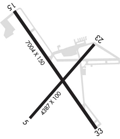
| Lat: N 4018.9 Long: W 07850.1 Elev: 2284 Var: +10 Longest Runway: 7004 | ||
| Clr Del: 126.85 Dept. ATIS: 118.32 Arr. ATIS: 118.32 Ground: 121.6 Tower: 125.75 | ||
| ||||||||||||||||||||||||||||||||||||||||||||
| ||||||||||||||||||||||||||||||||||||||||||||
| ||||||||||||||||||||||||||||||||||||||||||||
| Rwy | Rwy | |||||||
| 4387x100 | 4387' | 4387x100 | 4387' | |||||
| 7004x150 | 7004' | 7004x150 | 7004' | 110.10 - 334° | ||||
| Runway ID | Single Wheel | Double Wheel | Double Tandem Wheel | Dual Double Wheel |
| 05/23 | 62,000 | 87,000 | N/A | N/A |
| 15/33 | 93,000 | 183,000 | 357,000 | 845,000 |
| These numbers are Advisory and are not limits. The Airport Manager should have more accurate Weight Limits | ||||
 Airport Diagram might not be current. | |
| Facility Name: | JOHN MURTHA JOHNSTOWN/CAMBRIA COUNTY |
| City Name: | JOHNSTOWN |
| County: | CAMBRIA |
| State abbrev: | PA |
| State Name: | PENNSYLVANIA |
| Ownership: | PUBLICLY OWNED |
| Use: | OPEN TO THE PUBLIC |
| Owner's Name: | JOHNSTOWN-CAMBRIA CO APT AUTH |
| Address: | 479 ARPT ROAD |
| JOHNSTOWN, PA 15904 | |
| Owner's Phone: | 814-536-0002 |
| Manager's Name: | CORY CREE |
| Address: | 479 ARPT ROAD |
| JOHNSTOWN, PA 15904 | |
| Phone: | 814-536-0002 |
| FAA Region: | EASTERN |
| FAA Field Office: | HAR |

| Date | Sunrise | Sunset |
|---|---|---|
| 04/20/26 Monday | 6:30 | 19:59 |
| 04/21/26 Tuesday | 6:29 | 20:00 |
| 04/22/26 Wednesday | 6:27 | 20:01 |
| 04/23/26 Thursday | 6:26 | 20:02 |
| 04/24/26 Friday | 6:24 | 20:03 |
| 04/25/26 Saturday | 6:23 | 20:04 |
| 04/26/26 Sunday | 6:22 | 20:05 |
| 04/27/26 Monday | 6:20 | 20:06 |
| 04/28/26 Tuesday | 6:19 | 20:07 |
| 04/29/26 Wednesday | 6:18 | 20:08 |
| 04/30/26 Thursday | 6:16 | 20:09 |
| 05/01/26 Friday | 6:15 | 20:10 |
| 05/02/26 Saturday | 6:14 | 20:11 |
| 05/03/26 Sunday | 6:13 | 20:12 |
| Airport Attendance Schedule | 7 Days A Week 0700-2300 |
| Airport Status | OPERATIONAL (This Status can change at any time - please check NOTAMS) |
| Airport Lighting Schedule | WHEN TWR CLSD ACTVT MALSR RWY 33; PAPI RWY 33; HIRL RWY 15/33, MIRL RWY 5/23 AND ALL TWY LGTS - CTAF. PAPI RWY 05 UNAVBL WHEN ATCT CLSD. |
| Airport Storage Available | Tie Downs, Hanger |
| Extra Services Available | Air Freight, Charter, Flight Instruction, Aircraft Rental, Annual Surveying |
| Wind Indicator | YES - (lighted) |
| Control Tower | YES |
| CTAF Frequency | 125.750 |
| Unicom Frequency | 122.950; UNICOM FREQ 122.950 AVBL FOR GND SVCS ONLY. |
| Rotating Beacon Color | WG |
| Segmented Circle | NO |
| Landing Fee | YES |
| Airport Inspected | FEDERAL - performed by FAA AIRPORTS FIELD PERSONNEL |
| Inspection Date | 03/03/2026 |
| Type of Fuel Available | Grade 100LL, JET A (freeze point -40C), JET A |
| Airframe Repair Service | MAJOR |
| Power Plant Repair Service | MAJOR |
| Latitude | N4018.9 |
| Longitude | W07850.1 (ESTIMATED) |
| Arpt Elevation | 2284ft (SURVEYED) |
| Magnetic Variation | 10W |
| 3 miles NE | of JOHNSTOWN |
| Traffic Pattern Altitude | |
| Sectional Chart | DETROIT |
| Operations (Reported) | Yearly | Avg. Daily |
|---|---|---|
| General Aviation Transient | 0 | 0 |
| General Aviation Local | 0 | 0 |
| Air Taxi | 0 | 0 |
| Commerical | 0 | 0 |
| Commuter | 0 | 0 |
| Military | 0 | 0 |
| Aircraft based on Field | |
|---|---|
| General Aviation Singles | 0 |
| General Aviation Multi | 0 |
| Jet Aircraft | 0 |
| General Aviation Helicopters | 0 |
| Military Aircraft | 0 |
| Gliders | 0 |
| Ultralights | 0 |
| FSS on field | NO |
| FSS tie-in | ALTOONA |
| FSS Phone | 1-800-WX-BRIEF |
| Who issues Notams | JST |
| Notam D service at airport | YES |
| ARTCC Name | CLEVELAND |
| Airport Certification | AIRPORT RECEIVING SCHEDULED AIR CARRIER SERVICE FROM CARRIERS CERTIFICATED BY THE CIVIL AERONAUTICS BOARD; 48 HR PPR FOR UNSKED ACR OPS WITH MORE THAN 30 PAX SEATS; CALL AMGR 814-536-0002. |
| Aircraft Rescue & Firefighting Index | AIRPORT HAS A CERTIFICATE UNDER CFR PART 139 |
| Airport of Entry | No |
| Custom Landing Rights | No |
| Joint Civil/Military | No |
| Military Landing rights | No |
| NATIONAL PLAN OF INTEGRATED AIRPORT SYSTEMS (NPIAS) |
| GRANT AGREEMENTS UNDER FAAP/ADAP/AIP |
| ASSURANCES PURSUANT TO TITLE VI, CIVIL RIGHTS ACT OF 1964 |
| AGREEMENT UNDER DLAND OR DCLA HAS EXPIRED. |
| TWY B BTN RWY 05/23 AND TWY B2 RSTRD TO ACFT WITH WINGSPAN 78 FT OR LESS. |
| ARNG: RSTD PPR 24 HR, CALL DUR NML DUTY HOURS 1300-2130Z++ EXC WKEND AND HOL. CTC OPS C814-532-7720. ALL TFC TO ARNG MILITARY RAMP CTC KEYSTONE OPS: 138.55, 241.35, 46.75, RAMP DECONFLICTION 46.75. |
| DEER & BIRDS ON & INVOF ARPT. |
| FOR CD CTC JOHNSTOWN APCH AT 814-532-5960, WHEN APCH CLSD CTC CLEVELAND ARTCC AT 440-774-0213. |
| RWY 05/2 3 2S-110. |
| RWY 05/2 3 PCR VALUE: 240/F/D/X/T |
| RWY 15/3 3 PCR VALUE: 630/R/B/W/T |
Airport Communications & Frequencies:
| |||||||||||||||||||||||||||
| Runway: 05 | Runway: 23 | ||
| Mag heading: | 49° | Mag heading: | 229° |
| Rwy Slope: | .21% Up | Rwy Slope: | -.21% Down |
| Approach: | Approach: | ||
| Pattern: | Left Traffic | Pattern: | Left Traffic |
| Markings: | NONPRECISION INSTRUMENT | Markings: | NONPRECISION INSTRUMENT |
| Marking Condition: | GOOD | Marking Condition: | GOOD |
| Arresting Dev: | Arresting Dev: | ||
| Lat & Long: | N4018.6 W07850.4 | Lat. & Long.: | N4019.2 W07849.8 |
| Elev: | 2270.4 ft. MSL | Elev: | 2279.5 ft. MSL |
| TCH: | 44 ft. AGL | TCH: | 45 ft. AGL |
| Visual Glide Path: | 3.00 degrees | Visual Glide Path: | 3.00 degrees |
| Displaced Threshold: | No | Displaced Threshold: | No |
| Touchdown Zone: | YES | Touchdown Zone: | YES |
| Touchdown Elev.: | 2283.7 feet | Touchdown Elev.: | 2284.2 feet |
| Visual Glide Slope: | 4-Light PAPI on LEFT side of Runway | Visual Glide Slope: | 4-BOX VASI ON LEFT SIDE OF RUNWAY |
| RVR Equipment: | RVR Equipment: | ||
| RVV Equipment: | NO | RVV Equipment: | NO |
| Approach Lights: | Approach Lights: | ||
| REIL: | YES | REIL: | YES |
| Centerline Lights: | NO | Centerline Lights: | NO |
| Touchdown lights: | NO | Touchdown lights: | NO |
| Runway Category: | Runway with a Non-precision Approach having visibility minimums greater than 3/4 mile | Runway Category: | D |
| Declared Distances: | TORA:4387' TODA:4387' ASDA:4387' LDA:4387' | Declared Distances: | TORA:4387' TODA:4387' ASDA:4387' LDA:4387' |
| Obstructions: | TREES | Obstructions: | BLDG |
| Marked: | NOT Marked/Lighted | Marked: | NOT Marked/Lighted |
| Clearance slope: | 2:1 | Clearance slope: | 11:1 |
| Obstruction height: | 26 feet AGL | Obstruction height: | 46 feet AGL |
| Dist. from runway: | 261 feet | Dist. from runway: | 746 feet |
| Centerline offset: | 402 left of centerline | Centerline offset: | 576 feet right of centerline |
| Comments: | Comments: |
| Runway: 15 | Runway: 33 | ||
| Mag heading: | 154° | Mag heading: | 334° |
| Rwy Slope: | -.15% Down | Rwy Slope: | .15% Up |
| Approach: | Approach: | ILS | |
| Pattern: | Left Traffic | Pattern: | Left Traffic |
| Markings: | PRECISION INSTRUMENT | Markings: | PRECISION INSTRUMENT |
| Marking Condition: | GOOD | Marking Condition: | GOOD |
| Arresting Dev: | Arresting Dev: | ||
| Lat & Long: | N4019.4 W07850.5 | Lat. & Long.: | N4018.5 W07849.6 |
| Elev: | 2270.2 ft. MSL | Elev: | 2259.9 ft. MSL |
| TCH: | 52 ft. AGL | TCH: | 53 ft. AGL |
| Visual Glide Path: | 3.00 degrees | Visual Glide Path: | 3.00 degrees |
| Displaced Threshold: | No | Displaced Threshold: | No |
| Touchdown Zone: | YES | Touchdown Zone: | YES |
| Touchdown Elev.: | 2276.1 feet | Touchdown Elev.: | 2280.5 feet |
| Visual Glide Slope: | 4-BOX VASI ON LEFT SIDE OF RUNWAY | Visual Glide Slope: | 4-Light PAPI on RIGHT side of Runway |
| RVR Equipment: | RVR Equipment: | ||
| RVV Equipment: | NO | RVV Equipment: | NO |
| Approach Lights: | Approach Lights: | MALSR - 1,400 foot medium intensity approach lighting system with runway alignment indicator lights | |
| REIL: | NO | REIL: | NO |
| Centerline Lights: | NO | Centerline Lights: | NO |
| Touchdown lights: | NO | Touchdown lights: | NO |
| Runway Category: | D | Runway Category: | Precision Instrument Runway |
| Declared Distances: | TORA:7004' TODA:7004' ASDA:6698' LDA:6698' | Declared Distances: | TORA:7004' TODA:7004' ASDA:6484' LDA:6484' |
| Obstructions: | TREES | Obstructions: | TREES |
| Marked: | NOT Marked/Lighted | Marked: | NOT Marked/Lighted |
| Clearance slope: | 7:1 | Clearance slope: | 42:1 |
| Obstruction height: | 36 feet AGL | Obstruction height: | 17 feet AGL |
| Dist. from runway: | 480 feet | Dist. from runway: | 928 feet |
| Centerline offset: | 394 left of centerline | Centerline offset: | 436 feet right of centerline |
| Comments: | Comments: |
Thanks for using FltPlan.com
all rights reserved © 1999-2026 by Flight Plan LLC