| GOLDSBORO-WAYNE MUNI GOLDSBORO NC |
| |
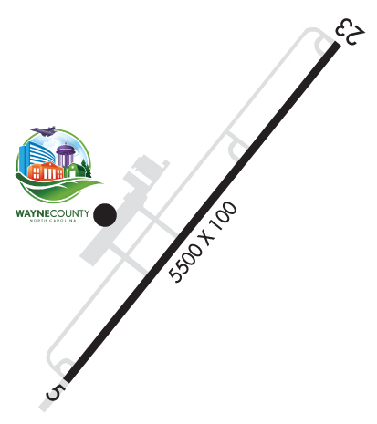
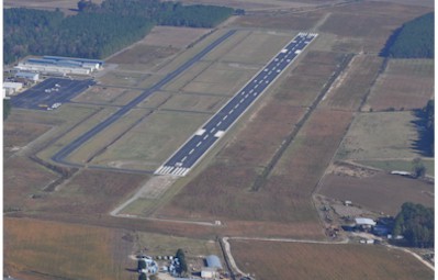
| Lat: N 3527.6 Long: W 07757.9 Elev: 134 Var: +08 Longest Runway: 5501 | ||
| AWOS: 118.97 CTAF: 122.97 | ||
| |||||||||||||||||||||||||||||||
| |||||||||||||||||||||||||||||||
| |||||||||||||||||||||||||||||||
| Rwy | Rwy | |||||||
| 5501x100 | 5501' | 5501x100 | 5501' | 111.90 - 226° | ||||
| Runway ID | Single Wheel | Double Wheel | Double Tandem Wheel | Dual Double Wheel |
| 05/23 | 51,000 | 71,000 | N/A | N/A |
| These numbers are Advisory and are not limits. The Airport Manager should have more accurate Weight Limits | ||||
 Airport Diagram might not be current. | |
| Facility Name: | WAYNE EXEC JETPORT |
| City Name: | GOLDSBORO |
| County: | WAYNE |
| State abbrev: | NC |
| State Name: | NORTH CAROLINA |
| Ownership: | PUBLICLY OWNED |
| Use: | OPEN TO THE PUBLIC |
| Owner's Name: | WAYNE COUNTY |
| Address: | 240 AVIATION ROAD |
| PIKEVILLE, NC 27863 | |
| Owner's Phone: | 919-734-7630 |
| Manager's Name: | GENE DAWSON |
| Address: | 240 AVIATION ROAD |
| PIKEVILLE, NC 27863 | |
| Phone: | 919-734-7630 |
| FAA Region: | SOUTHERN |
| FAA Field Office: | MEM |
| Date | Sunrise | Sunset |
|---|---|---|
| 04/03/26 Friday | 6:56 | 19:35 |
| 04/04/26 Saturday | 6:55 | 19:36 |
| 04/05/26 Sunday | 6:53 | 19:37 |
| 04/06/26 Monday | 6:52 | 19:37 |
| 04/07/26 Tuesday | 6:51 | 19:38 |
| 04/08/26 Wednesday | 6:49 | 19:39 |
| 04/09/26 Thursday | 6:48 | 19:40 |
| 04/10/26 Friday | 6:46 | 19:41 |
| 04/11/26 Saturday | 6:45 | 19:41 |
| 04/12/26 Sunday | 6:44 | 19:42 |
| 04/13/26 Monday | 6:42 | 19:43 |
| 04/14/26 Tuesday | 6:41 | 19:44 |
| 04/15/26 Wednesday | 6:40 | 19:45 |
| 04/16/26 Thursday | 6:38 | 19:46 |
| Airport Attendance Schedule | MON-SAT 0800-1700, SUN 1300-1700; UNATNDD FEDERAL HOL. |
| Airport Status | OPERATIONAL (This Status can change at any time - please check NOTAMS) |
| Airport Lighting Schedule | ACTVT REIL RWY 05 & 23; ODALS RWY 23; MIRL RWY 05/23 - CTAF. PAPIS RWY 05 & 23 OPERS CONS. |
| Airport Storage Available | Tie Downs, Hanger |
| Extra Services Available | Crop Dusting, Flight Instruction, Aircraft Rental, Aircraft Sales |
| Wind Indicator | YES - (lighted) |
| Control Tower | NO |
| CTAF Frequency | 122.975 |
| Unicom Frequency | 122.975 |
| Rotating Beacon Color | WG |
| Segmented Circle | YES |
| Landing Fee | NO |
| Airport Inspected | STATE - performed by STATE AERONAUTICAL PERSONNEL |
| Inspection Date | 05/12/2023 |
| Type of Fuel Available | Grade 100LL, JET A-1 (icing inhibitor, freeze point -50C); -1024 HR SS FUEL AVAILABLE W CC. |
| Airframe Repair Service | MAJOR |
| Power Plant Repair Service | MAJOR |
| Latitude | N3527.6 |
| Longitude | W07757.9 (ESTIMATED) |
| Arpt Elevation | 133ft (SURVEYED) |
| Magnetic Variation | 08W |
| 3 miles N | of GOLDSBORO |
| Traffic Pattern Altitude | |
| Sectional Chart | CHARLOTTE |
| Operations (Reported) | Yearly | Avg. Daily |
|---|---|---|
| General Aviation Transient | 0 | 0 |
| General Aviation Local | 0 | 0 |
| Air Taxi | 0 | 0 |
| Commerical | 0 | 0 |
| Commuter | 0 | 0 |
| Military | 0 | 0 |
| Aircraft based on Field | |
|---|---|
| General Aviation Singles | 0 |
| General Aviation Multi | 0 |
| Jet Aircraft | 0 |
| General Aviation Helicopters | 0 |
| Military Aircraft | 0 |
| Gliders | 0 |
| Ultralights | 0 |
| FSS on field | NO |
| FSS tie-in | RALEIGH |
| FSS Phone | 1-800-WX-BRIEF |
| Who issues Notams | GWW |
| Notam D service at airport | YES |
| ARTCC Name | WASHINGTON |
| Airport Certification | |
| Aircraft Rescue & Firefighting Index | None |
| Airport of Entry | No |
| Custom Landing Rights | No |
| Joint Civil/Military | No |
| Military Landing rights | YES |
| NATIONAL PLAN OF INTEGRATED AIRPORT SYSTEMS (NPIAS) |
| GRANT AGREEMENTS UNDER FAAP/ADAP/AIP |
| ASSURANCES PURSUANT TO TITLE VI, CIVIL RIGHTS ACT OF 1964 |
| ULTRALIGHT; GLIDER & PARACHUTE ACTIVITY PPR CALL 919-734-7630. |
| HELICOPTER OPS ON TWY LEADING TO T HANGERS. HELIPAD ON TWY WITH TRAFFIC CONES AND FLAGS. |
| BIRD ACTIVITY INVOF ARPT. |
| FOR EMERG SVC AFT HRS CALL 919-734-7630. |
| FOR CD CTC SEYMOUR JOHNSON APCH AT 919-722-4186. WHEN APCH CLSD, FOR CD CTC WASHINGTON ARTCC AT 703-771-3587. |
Airport Communications & Frequencies:
| |||||||||||||||||
| Runway: 05 | Runway: 23 | ||
| Mag heading: | 47° | Mag heading: | 227° |
| Rwy Slope: | .00% | Rwy Slope: | .00% |
| Approach: | Approach: | ILS | |
| Pattern: | Left Traffic | Pattern: | Left Traffic |
| Markings: | NONPRECISION INSTRUMENT | Markings: | PRECISION INSTRUMENT |
| Marking Condition: | GOOD | Marking Condition: | GOOD |
| Arresting Dev: | Arresting Dev: | ||
| Lat & Long: | N3527.3 W07758.2 | Lat. & Long.: | N3528.0 W07757.5 |
| Elev: | 132.7 ft. MSL | Elev: | 132.7 ft. MSL |
| TCH: | 40 ft. AGL | TCH: | 44 ft. AGL |
| Visual Glide Path: | 3.00 degrees | Visual Glide Path: | 3.00 degrees |
| Displaced Threshold: | No | Displaced Threshold: | No |
| Touchdown Zone: | YES | Touchdown Zone: | YES |
| Touchdown Elev.: | 132.7 feet | Touchdown Elev.: | 133.6 feet |
| Visual Glide Slope: | 4-Light PAPI on LEFT side of Runway | Visual Glide Slope: | 4-Light PAPI on LEFT side of Runway |
| RVR Equipment: | RVR Equipment: | ||
| RVV Equipment: | NO | RVV Equipment: | NO |
| Approach Lights: | Approach Lights: | ODALS - omnidirectional approach lighting system | |
| REIL: | YES | REIL: | YES |
| Centerline Lights: | NO | Centerline Lights: | NO |
| Touchdown lights: | NO | Touchdown lights: | NO |
| Runway Category: | Runway with a Non-precision Approach having visibility minimums greater than 3/4 mile | Runway Category: | Precision Instrument Runway |
| Declared Distances: | Declared Distances: | ||
| Obstructions: | TREES | Obstructions: | TREES |
| Marked: | NOT Marked/Lighted | Marked: | NOT Marked/Lighted |
| Clearance slope: | 21:1 | Clearance slope: | 11:1 |
| Obstruction height: | 93 feet AGL | Obstruction height: | 52 feet AGL |
| Dist. from runway: | 2163 feet | Dist. from runway: | 782 feet |
| Centerline offset: | 393 right of centerline | Centerline offset: | 581 feet right of centerline |
| Comments: | HAS 9 FT BRUSH 135 FT FM THR OFFSET 327 LEFT OF CNTRLN. | Comments: |
Thanks for using FltPlan.com
all rights reserved © 1999-2026 by Flight Plan LLC