
| PEARSON FIELD VANCOUVER WA |
| |
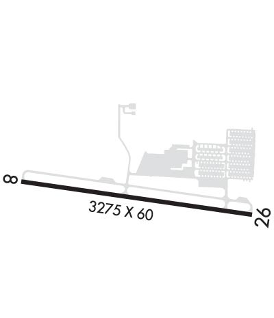
| Lat: N 4537.2 Long: W 12239.4 Elev: 29 Var: -16 Longest Runway: 3275 | ||
| Clr Del: 119.0 AWOS: 135.12 CTAF: 119.00 | ||
| ||||||
| ||||||
|
| Rwy | Rwy | |||||||
| 3275x60 | 3275' | 3275x60 | 2513' | |||||
| Runway ID | Single Wheel | Double Wheel | Double Tandem Wheel | Dual Double Wheel |
| 08/26 | N/A | N/A | N/A | N/A |
| These numbers are Advisory and are not limits. The Airport Manager should have more accurate Weight Limits | ||||
 Airport Diagram might not be current. | |
| Facility Name: | PEARSON FLD |
| City Name: | VANCOUVER |
| County: | CLARK |
| State abbrev: | WA |
| State Name: | WASHINGTON |
| Ownership: | PUBLICLY OWNED |
| Use: | OPEN TO THE PUBLIC |
| Owner's Name: | CITY OF VANCOUVER &NPS |
| Address: | PO BOX 1995 |
| VANCOUVER, WA 98660 | |
| Owner's Phone: | 360-487-8619 |
| Manager's Name: | MEREDITH FOX |
| Address: | PO BOX 1995 |
| VANCOUVER, WA 98660 | |
| Phone: | 360-487-8619; 360-904-9007. |
| FAA Region: | NORTHWEST MOUNTAIN |
| FAA Field Office: | SEA |
| Date | Sunrise | Sunset |
|---|---|---|
| 07/21/25 Monday | 5:42 | 20:52 |
| 07/22/25 Tuesday | 5:43 | 20:51 |
| 07/23/25 Wednesday | 5:44 | 20:50 |
| 07/24/25 Thursday | 5:45 | 20:49 |
| 07/25/25 Friday | 5:46 | 20:48 |
| 07/26/25 Saturday | 5:47 | 20:46 |
| 07/27/25 Sunday | 5:48 | 20:45 |
| 07/28/25 Monday | 5:49 | 20:44 |
| 07/29/25 Tuesday | 5:51 | 20:43 |
| 07/30/25 Wednesday | 5:52 | 20:42 |
| 07/31/25 Thursday | 5:53 | 20:40 |
| 08/01/25 Friday | 5:54 | 20:39 |
| 08/02/25 Saturday | 5:55 | 20:38 |
| 08/03/25 Sunday | 5:56 | 20:37 |
| Airport Attendance Schedule | NOV-MAR 7 Days A Week 0800-1700, APR-OCT 7 Days A Week 0800-1800 |
| Airport Status | OPERATIONAL (This Status can change at any time - please check NOTAMS) |
| Airport Lighting Schedule | ACTVT PAPI RWY 26; MIRL RWY 08/26 - CTAF. |
| Airport Storage Available | Tie Downs |
| Extra Services Available | Avionics, Flight Instruction, Aircraft Rental, Aircraft Sales |
| Wind Indicator | YES - (lighted) |
| Control Tower | NO |
| CTAF Frequency | 119.000 |
| Unicom Frequency | |
| Rotating Beacon Color | |
| Segmented Circle | YES |
| Landing Fee | NO |
| Airport Inspected | STATE - performed by STATE AERONAUTICAL PERSONNEL |
| Inspection Date | 08/01/2023 |
| Type of Fuel Available | Grade 100LL; -10SELF SVC CREDIT CARD H24. |
| Airframe Repair Service | MAJOR |
| Power Plant Repair Service | MAJOR |
| Latitude | N4537.2 |
| Longitude | W12239.4 (ESTIMATED) |
| Arpt Elevation | 28ft (SURVEYED) |
| Magnetic Variation | 16E |
| 2 miles SW | of VANCOUVER |
| Traffic Pattern Altitude | 1000 |
| Sectional Chart | SEATTLE |
| Operations (Reported) | Yearly | Avg. Daily |
|---|---|---|
| General Aviation Transient | 0 | 0 |
| General Aviation Local | 0 | 0 |
| Air Taxi | 0 | 0 |
| Commerical | 0 | 0 |
| Commuter | 0 | 0 |
| Military | 0 | 0 |
| Aircraft based on Field | |
|---|---|
| General Aviation Singles | 0 |
| General Aviation Multi | 0 |
| Jet Aircraft | 0 |
| General Aviation Helicopters | 0 |
| Military Aircraft | 0 |
| Gliders | 0 |
| Ultralights | 0 |
| FSS on field | NO |
| FSS tie-in | SEATTLE |
| FSS Phone | 1-800-WX-BRIEF |
| Who issues Notams | VUO |
| Notam D service at airport | YES |
| ARTCC Name | SEATTLE |
| Airport Certification | |
| Aircraft Rescue & Firefighting Index | None |
| Airport of Entry | No |
| Custom Landing Rights | No |
| Joint Civil/Military | No |
| Military Landing rights | YES |
| NATIONAL PLAN OF INTEGRATED AIRPORT SYSTEMS (NPIAS) |
| GRANT AGREEMENTS UNDER FAAP/ADAP/AIP |
| SURPLUS PROPERTY AGREEMENT UNDER PUBLIC LAW 289 |
| ASSURANCES PURSUANT TO TITLE VI, CIVIL RIGHTS ACT OF 1964 |
| THIS AIRPORT HAS BEEN SURVEYED BY THE NATIONAL GEODETIC SURVEY. |
| PPR TO ACESS AIR MUSEUM TXL. |
| OPS OVR CNTRLN OR EXTDD CNTRLN MNTN AT OR BLW 700 FT MSL DUE TO PORTLAND INTL TFC; PORTLAND INTL RWY 10L/28R EXTDD CNTRLN XS RWY 08 THR. |
| GEESE ON & INVOF ARPT. |
| OTFC FORT VANCOUVER STOCKADE NATIONAL PARK 360 FT N OF RWY 08 NA. |
| ARR PRIOR TO ENTERING SFRA FAR 93.163 & DEP BFR TKOF - CTC CTAF. |
| MANDATORY VFR ADVZY SVC - CTC CTAF. |
| SEE SPL NOTICE FOR FULL PROC APCH - 866-640-4124. |
| RWY 08/2 6 STWY W END. |
| RWY 08/2 6 2513 FT LGTD AT NIGHT. |
Airport Communications & Frequencies:
| |||||||||||||||||||||
| Runway: 08 | Runway: 26 | ||
| Mag heading: | 82° | Mag heading: | 262° |
| Rwy Slope: | -.20% Down | Rwy Slope: | .20% Up |
| Approach: | Approach: | ||
| Pattern: | Left Traffic | Pattern: | Right Traffic |
| Markings: | BASIC | Markings: | BASIC |
| Marking Condition: | FAIR | Marking Condition: | FAIR |
| Arresting Dev: | Arresting Dev: | ||
| Lat & Long: | N4537.3 W12239.8 | Lat. & Long.: | N4537.2 W12239.0 |
| Elev: | 28.6 ft. MSL | Elev: | 22.2 ft. MSL |
| TCH: | 31 ft. AGL | TCH: | 32 ft. AGL |
| Visual Glide Path: | 3.75 degrees | Visual Glide Path: | 4.00 degrees |
| Displaced Threshold: | No | Displaced Threshold: | 762 feet; FOR NIGHT OPS. |
| Touchdown Zone: | YES | Touchdown Zone: | YES |
| Touchdown Elev.: | 28.6 feet | Touchdown Elev.: | 28.6 feet |
| Visual Glide Slope: | 4-BOX VASI ON RIGHT SIDE OF RUNWAY; VASI RWY 08 UNUSBL BYD 6 DEG L OR R OF RWY CNTRLN. | Visual Glide Slope: | 2-Light PAPI on RIGHT side of Runway |
| RVR Equipment: | RVR Equipment: | ||
| RVV Equipment: | NO | RVV Equipment: | NO |
| Approach Lights: | Approach Lights: | ||
| REIL: | NO | REIL: | YES |
| Centerline Lights: | NO | Centerline Lights: | NO |
| Touchdown lights: | NO | Touchdown lights: | NO |
| Runway Category: | Runway with a Visual Approach | Runway Category: | Runway with a Visual Approach |
| Declared Distances: | TORA:3275' TODA:3275' ASDA:3065' LDA:3065' | Declared Distances: | TORA:3275' TODA:3275' ASDA:3275' LDA:2513' |
| Obstructions: | BRDG | Obstructions: | TREE |
| Marked: | NOT Marked/Lighted | Marked: | NOT Marked/Lighted |
| Clearance slope: | 11:1 | Clearance slope: | 2:1; APCH SLOPE 44:1 AT DTHR. |
| Obstruction height: | 218 feet AGL | Obstruction height: | 31 feet AGL |
| Dist. from runway: | 2647 feet | Dist. from runway: | 280 feet |
| Centerline offset: | 482 right of centerline | Centerline offset: | |
| Comments: | Comments: | +16 FT DIKE AT 115 FT; 6 FT FENCE AT 130 FT. |
Thanks for using FltPlan.com
all rights reserved © 1999-2025 by Flight Plan LLC
