| OHIO UNIVERSITY SNYDER FIELD ATHENS/ALBANY OH |
| |
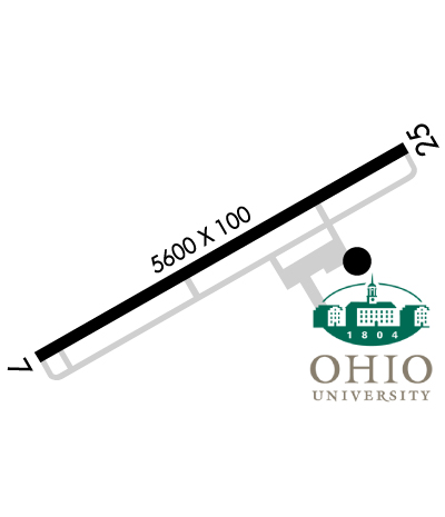
| Lat: N 3912.7 Long: W 08213.8 Elev: 766 Var: +06 Longest Runway: 5600 | ||
| Clr Del: 120.95 AWOS: 128.32 CTAF: 123.07 | ||
| |||||||||||||||||||||||
| |||||||||||||||||||||||
| |||||||||||||||||||||||
| Rwy | Rwy | |||||||
| 5600x100 | 4700' | 5600x100 | 5600' | 108.75 - 246° | ||||
| Runway ID | Single Wheel | Double Wheel | Double Tandem Wheel | Dual Double Wheel |
| 07/25 | 56,500 | 82,000 | N/A | N/A |
| These numbers are Advisory and are not limits. The Airport Manager should have more accurate Weight Limits | ||||
 Airport Diagram might not be current. | |
| Facility Name: | OHIO UNIVERSITY |
| City Name: | ATHENS/ALBANY |
| County: | ATHENS |
| State abbrev: | OH |
| State Name: | OHIO |
| Ownership: | PUBLICLY OWNED |
| Use: | OPEN TO THE PUBLIC |
| Owner's Name: | OHIO UNIVERSITY |
| Address: | 747 COLUMBIA ROAD |
| ALBANY, OH 45710 | |
| Owner's Phone: | 740-597-2600 |
| Manager's Name: | VICKI SMITH; ALTERNATE CONTACT: TODD MCGUIRE, 740-597-2609, MCGUIRET@OHIO.EDU |
| Address: | 747 COLUMBIA ROAD |
| ALBANY, OH 45710 | |
| Phone: | (740) 597-2602; EMERGENCY CALL 740-597-2600. |
| FAA Region: | GREAT LAKES |
| FAA Field Office: | DET |
| Date | Sunrise | Sunset |
|---|---|---|
| 09/24/21 Friday | 7:18 | 19:23 |
| 09/25/21 Saturday | 7:19 | 19:22 |
| 09/26/21 Sunday | 7:20 | 19:20 |
| 09/27/21 Monday | 7:21 | 19:18 |
| 09/28/21 Tuesday | 7:22 | 19:17 |
| 09/29/21 Wednesday | 7:23 | 19:15 |
| 09/30/21 Thursday | 7:24 | 19:13 |
| 10/01/21 Friday | 7:25 | 19:12 |
| 10/02/21 Saturday | 7:26 | 19:10 |
| 10/03/21 Sunday | 7:27 | 19:09 |
| 10/04/21 Monday | 7:28 | 19:07 |
| 10/05/21 Tuesday | 7:29 | 19:06 |
| 10/06/21 Wednesday | 7:29 | 19:04 |
| 10/07/21 Thursday | 7:30 | 19:02 |
| Airport Attendance Schedule | CONTINUOUS |
| Airport Status | OPERATIONAL (This Status can change at any time - please check NOTAMS) |
| Airport Lighting Schedule | ACTVT MIRL RY 07/25, & REIL RYS 07 & 25 - CTAF. PAPI RYS 07 & 25 OPER 24 HRS. |
| Airport Storage Available | Tie Downs, Hanger |
| Extra Services Available | Flight Instruction, Aircraft Rental |
| Wind Indicator | YES - (lighted) |
| Control Tower | NO |
| CTAF Frequency | 123.075 |
| Unicom Frequency | 123.075 |
| Rotating Beacon Color | CLEAR-GREEN (Light Land Airport) |
| Segmented Circle | NO |
| Landing Fee | NO |
| Airport Inspected | STATE - performed by STATE AERONAUTICAL PERSONNEL |
| Inspection Date | 08/15/2018 |
| Type of Fuel Available | Grade 100LL, JET A (freeze point -40C) |
| Airframe Repair Service | MAJOR |
| Power Plant Repair Service | MAJOR |
| Latitude | N3912.7 |
| Longitude | W08213.8 (ESTIMATED) |
| Arpt Elevation | 765ft (SURVEYED) |
| Magnetic Variation | 06W |
| 10 miles SW | of ATHENS/ALBANY |
| Traffic Pattern Altitude | TPA TURBINE ACFR ( EXCEPT HELICOPTERS) 1534 AGL, MULTI ENGINE RECIP 1234 AGL, ALL OTHERS 1034 AGL. |
| Sectional Chart | CINCINNATI |
| Operations (Reported) | Yearly | Avg. Daily |
|---|---|---|
| General Aviation Transient | 10222 | 28 |
| General Aviation Local | 42112 | 115 |
| Air Taxi | 200 | 1 |
| Commerical | 0 | 0 |
| Commuter | 0 | 0 |
| Military | 200 | 1 |
| Aircraft based on Field | |
|---|---|
| General Aviation Singles | 35 |
| General Aviation Multi | 8 |
| Jet Aircraft | 0 |
| General Aviation Helicopters | 0 |
| Military Aircraft | 0 |
| Gliders | 0 |
| Ultralights | 0 |
| FSS on field | NO |
| FSS tie-in | DAYTON |
| FSS Phone | 1-800-WX-BRIEF |
| Who issues Notams | DAY |
| Notam D service at airport | YES |
| ARTCC Name | INDIANAPOLIS |
| Airport Certification | |
| Aircraft Rescue & Firefighting Index | None |
| Airport of Entry | No |
| Custom Landing Rights | No |
| Joint Civil/Military | No |
| Military Landing rights | YES |
| NATIONAL PLAN OF INTEGRATED AIRPORT SYSTEMS (NPIAS) |
| GRANT AGREEMENTS UNDER FAAP/ADAP/AIP |
| ADVANCE PLANNING AGREEMENT UNDER FAAP |
| ASSURANCES PURSUANT TO TITLE VI, CIVIL RIGHTS ACT OF 1964 |
| DEER & WATERFOWL INVOF ARPT. |
| RY 7/25 L TFC ONLY. EXTENSIVE FLIGHT TRAINING, MAKE EVERY EFFORT TO OBSERVE TPAS. AVOID OVERFLIGHT OF NOISE SENSITIVE AREAS, CHURCH 1.8 MI NW OF RY 25 END & VILLAGE OF ALBANY 2 MI E OF APCH END RY 25. |
Airport Communications & Frequencies:
| ||||||||||||||||
| Runway: 07 | Runway: 25 | ||
| Mag heading: | 67° | Mag heading: | 247° |
| Rwy Slope: | -.09% Down | Rwy Slope: | .09% Up |
| Approach: | Approach: | LOC/GS | |
| Pattern: | Left Traffic | Pattern: | Left Traffic |
| Markings: | NONPRECISION INSTRUMENT | Markings: | PRECISION INSTRUMENT |
| Marking Condition: | GOOD | Marking Condition: | GOOD |
| Arresting Dev: | Arresting Dev: | ||
| Lat & Long: | N3912.5 W08214.3 | Lat. & Long.: | N3912.9 W08213.2 |
| Elev: | 765.4 ft. MSL | Elev: | 760.5 ft. MSL |
| TCH: | 25 ft. AGL | TCH: | 50 ft. AGL |
| Visual Glide Path: | 3.00 degrees | Visual Glide Path: | 3.00 degrees |
| Displaced Threshold: | 900 feet | Displaced Threshold: | No |
| Touchdown Zone: | YES | Touchdown Zone: | YES |
| Touchdown Elev.: | 764.7 feet | Touchdown Elev.: | 764.7 feet |
| Visual Glide Slope: | 4-Light PAPI on LEFT side of Runway | Visual Glide Slope: | 4-Light PAPI on LEFT side of Runway |
| RVR Equipment: | RVR Equipment: | ||
| RVV Equipment: | NO | RVV Equipment: | NO |
| Approach Lights: | Approach Lights: | ||
| REIL: | YES; RY 07 REIL LOCATED 949 FT FM RY END. | REIL: | YES |
| Centerline Lights: | NO | Centerline Lights: | NO |
| Touchdown lights: | NO | Touchdown lights: | NO |
| Runway Category: | Runway with a Non-precision Approach having visibility minimums greater than 3/4 mile | Runway Category: | Precision Instrument Runway |
| Declared Distances: | Declared Distances: | ||
| Obstructions: | TREES | Obstructions: | TREES |
| Marked: | NOT Marked/Lighted | Marked: | NOT Marked/Lighted |
| Clearance slope: | 12:1; DSPLCD THR 16:1 DUE TO +63 FT TREES 1016 FT FM RWY 547 FT R. | Clearance slope: | 23:1 |
| Obstruction height: | 103 feet AGL | Obstruction height: | 39 feet AGL |
| Dist. from runway: | 1458 feet | Dist. from runway: | 1110 feet |
| Centerline offset: | 584 left of centerline | Centerline offset: | 548 feet left of centerline |
| Comments: | Comments: |
Thanks for using FltPlan.com
all rights reserved © 1999-2021 by Flight Plan LLC