
| PETER O KNIGHT TAMPA FL |
| |
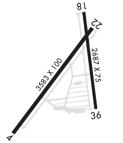
| Lat: N 2754.9 Long: W 08227.0 Elev: 7 Var: +05 Longest Runway: 3583 | ||
| Clr Del: 119.8 AWOS: 118.92 CTAF: 122.72 | ||
| ||||||||||||||||||||||||||||||||||||||||||||
| ||||||||||||||||||||||||||||||||||||||||||||
| ||||||||||||||||||||||||||||||||||||||||||||
| Rwy | Rwy | |||||||
| 3583x100 | 3404' | 3583x100 | 3403' | |||||
| 2687x75 | 2484' | 2687x75 | 2486' | |||||
| Runway ID | Single Wheel | Double Wheel | Double Tandem Wheel | Dual Double Wheel |
| 04/22 | 75,000 | 108,000 | N/A | N/A |
| 18/36 | 27,000 | 42,000 | N/A | N/A |
| These numbers are Advisory and are not limits. The Airport Manager should have more accurate Weight Limits | ||||
 Airport Diagram might not be current. | |
| Facility Name: | PETER O KNIGHT |
| City Name: | TAMPA |
| County: | HILLSBOROUGH |
| State abbrev: | FL |
| State Name: | FLORIDA |
| Ownership: | PUBLICLY OWNED |
| Use: | OPEN TO THE PUBLIC |
| Owner's Name: | HILLSBOROUGH COUNTY AVIATION AUTH; JOHN TILIACOS |
| Address: | PO BOX 22287 |
| TAMPA, FL 33622 | |
| Owner's Phone: | (813) 870-8776; 813-251-1752 |
| Manager's Name: | BRETT FAY |
| Address: | PO BOX 22287 |
| TAMPA, FL 33606 | |
| Phone: | (813) 870-8735 |
| FAA Region: | SOUTHERN |
| FAA Field Office: | ORL |

| Date | Sunrise | Sunset |
|---|---|---|
| 09/24/21 Friday | 7:19 | 19:24 |
| 09/25/21 Saturday | 7:20 | 19:23 |
| 09/26/21 Sunday | 7:20 | 19:22 |
| 09/27/21 Monday | 7:21 | 19:21 |
| 09/28/21 Tuesday | 7:21 | 19:20 |
| 09/29/21 Wednesday | 7:21 | 19:18 |
| 09/30/21 Thursday | 7:22 | 19:17 |
| 10/01/21 Friday | 7:22 | 19:16 |
| 10/02/21 Saturday | 7:23 | 19:15 |
| 10/03/21 Sunday | 7:23 | 19:14 |
| 10/04/21 Monday | 7:24 | 19:13 |
| 10/05/21 Tuesday | 7:25 | 19:12 |
| 10/06/21 Wednesday | 7:25 | 19:10 |
| 10/07/21 Thursday | 7:26 | 19:09 |
| Airport Attendance Schedule | 7 Days A Week 0700-1900 |
| Airport Status | OPERATIONAL (This Status can change at any time - please check NOTAMS) |
| Airport Lighting Schedule | ACTVT REIL RWY 22; VASI RWY 04; PAPI RWY 36; MIRL RWY 04/22 & 18/36 - CTAF. |
| Airport Storage Available | Tie Downs, Hanger |
| Extra Services Available | Avionics, Charter, Flight Instruction, Aircraft Rental |
| Wind Indicator | YES - (lighted) |
| Control Tower | NO |
| CTAF Frequency | 122.725 |
| Unicom Frequency | 122.725 |
| Rotating Beacon Color | CLEAR-GREEN (Light Land Airport) |
| Segmented Circle | Y-L |
| Landing Fee | NO |
| Airport Inspected | STATE - performed by STATE AERONAUTICAL PERSONNEL |
| Inspection Date | 12/13/2017 |
| Type of Fuel Available | Grade 100LL, JET A (freeze point -40C) |
| Airframe Repair Service | MAJOR |
| Power Plant Repair Service | MAJOR |
| Latitude | N2754.9 |
| Longitude | W08227.0 (ESTIMATED) |
| Arpt Elevation | 7ft (SURVEYED) |
| Magnetic Variation | 05W |
| 3 miles S | of TAMPA |
| Traffic Pattern Altitude | 900 |
| Sectional Chart | MIAMI |
| Operations (Reported) | Yearly | Avg. Daily |
|---|---|---|
| General Aviation Transient | 29000 | 79 |
| General Aviation Local | 21000 | 58 |
| Air Taxi | 3800 | 10 |
| Commerical | 0 | 0 |
| Commuter | 0 | 0 |
| Military | 0 | 0 |
| Aircraft based on Field | |
|---|---|
| General Aviation Singles | 82 |
| General Aviation Multi | 5 |
| Jet Aircraft | 0 |
| General Aviation Helicopters | 6 |
| Military Aircraft | 0 |
| Gliders | 0 |
| Ultralights | 0 |
| FSS on field | NO |
| FSS tie-in | SAINT PETERSBURG |
| FSS Phone | 1-800-WX-BRIEF |
| Who issues Notams | TPF |
| Notam D service at airport | YES |
| ARTCC Name | MIAMI |
| Airport Certification | |
| Aircraft Rescue & Firefighting Index | None |
| Airport of Entry | No |
| Custom Landing Rights | No |
| Joint Civil/Military | No |
| Military Landing rights | YES |
| NATIONAL PLAN OF INTEGRATED AIRPORT SYSTEMS (NPIAS) |
| GRANT AGREEMENTS UNDER FAAP/ADAP/AIP |
| ASSURANCES PURSUANT TO TITLE VI, CIVIL RIGHTS ACT OF 1964 |
| OCEAN VESSEL SHIP CHANNEL EAST. |
| GULLS ON AND INVOF ARPT. |
| TWY E CLSD TO ACFT WITH WING SPANS IN EXCESS OF 40 FT. |
| ALERT: MACDILL AFB LCTD 4 MILES SW & HOSP HEL TFC 1 NM NORTH USING UNICOM 122.825. |
| FOR CD CTC TAMPA APCH AT 813-878-2528 |
| RWY 18 SHIP CHANNEL APCH END. |
| RWY 22 SHIP CHANNEL APCH END. |
Airport Communications & Frequencies:
| ||||||||||||||||
| Runway: 04 | Runway: 22 | ||
| Mag heading: | 42° | Mag heading: | 222° |
| Rwy Slope: | -.03% Down | Rwy Slope: | .03% Up |
| Approach: | Approach: | ||
| Pattern: | Right Traffic | Pattern: | Left Traffic |
| Markings: | NONPRECISION INSTRUMENT | Markings: | NONPRECISION INSTRUMENT |
| Marking Condition: | GOOD | Marking Condition: | GOOD |
| Arresting Dev: | Arresting Dev: | ||
| Lat & Long: | N2754.7 W08227.2 | Lat. & Long.: | N2755.1 W08226.8 |
| Elev: | 6.9 ft. MSL | Elev: | 6.0 ft. MSL |
| TCH: | 36 ft. AGL | TCH: | |
| Visual Glide Path: | 3.00 degrees | Visual Glide Path: | |
| Displaced Threshold: | 179 feet | Displaced Threshold: | 180 feet |
| Touchdown Zone: | YES | Touchdown Zone: | YES |
| Touchdown Elev.: | 7.0 feet | Touchdown Elev.: | 6.8 feet |
| Visual Glide Slope: | 4-BOX VASI ON LEFT SIDE OF RUNWAY | Visual Glide Slope: | |
| RVR Equipment: | RVR Equipment: | ||
| RVV Equipment: | NO | RVV Equipment: | NO |
| Approach Lights: | Approach Lights: | ||
| REIL: | NO | REIL: | YES |
| Centerline Lights: | NO | Centerline Lights: | NO |
| Touchdown lights: | NO | Touchdown lights: | NO |
| Runway Category: | Runway with a Visual Approach | Runway Category: | Runway with a Non-precision Approach |
| Declared Distances: | TORA:3403' TODA:3403' ASDA:3403' LDA:3224' | Declared Distances: | TORA:3404' TODA:3404' ASDA:3404' LDA:3403' |
| Obstructions: | FENCE | Obstructions: | BOAT |
| Marked: | NOT Marked/Lighted | Marked: | NOT Marked/Lighted |
| Clearance slope: | 1:1; APCH RATIO 28:1 TO DTHR. | Clearance slope: | 7:1; APCH RATIO 25:1 TO DTHR. |
| Obstruction height: | 6 feet AGL | Obstruction height: | 30 feet AGL |
| Dist. from runway: | 200 feet | Dist. from runway: | 415 feet |
| Centerline offset: | 222 right of centerline | Centerline offset: | 170 feet right of centerline |
| Comments: | 6 FT FENCE 200 FT FM RWY END 222 FT R. | Comments: |
| Runway: 18 | Runway: 36 | ||
| Mag heading: | 178° | Mag heading: | 358° |
| Rwy Slope: | .01% Up | Rwy Slope: | -.01% Down |
| Approach: | Approach: | ||
| Pattern: | Left Traffic | Pattern: | Right Traffic |
| Markings: | NONPRECISION INSTRUMENT | Markings: | NONPRECISION INSTRUMENT |
| Marking Condition: | GOOD | Marking Condition: | GOOD |
| Arresting Dev: | Arresting Dev: | ||
| Lat & Long: | N2755.2 W08226.9 | Lat. & Long.: | N2754.8 W08226.8 |
| Elev: | 5.9 ft. MSL | Elev: | 6.3 ft. MSL |
| TCH: | TCH: | 34 ft. AGL | |
| Visual Glide Path: | Visual Glide Path: | 3.00 degrees | |
| Displaced Threshold: | 203 feet | Displaced Threshold: | 201 feet |
| Touchdown Zone: | YES | Touchdown Zone: | YES |
| Touchdown Elev.: | 7.4 feet | Touchdown Elev.: | 7.4 feet |
| Visual Glide Slope: | Visual Glide Slope: | 2-Light PAPI on RIGHT side of Runway | |
| RVR Equipment: | RVR Equipment: | ||
| RVV Equipment: | NO | RVV Equipment: | NO |
| Approach Lights: | Approach Lights: | ||
| REIL: | NO | REIL: | NO |
| Centerline Lights: | NO | Centerline Lights: | NO |
| Touchdown lights: | NO | Touchdown lights: | NO |
| Runway Category: | Runway with a Visual Approach | Runway Category: | Runway with a Non-precision Approach |
| Declared Distances: | TORA:2687' TODA:2687' ASDA:2574' LDA:2371' | Declared Distances: | TORA:2487' TODA:2487' ASDA:2512' LDA:2311' |
| Obstructions: | FENCE | Obstructions: | FENCE |
| Marked: | NOT Marked/Lighted | Marked: | NOT Marked/Lighted |
| Clearance slope: | 1:1; APCH RATIO 20:1 TO DTHR. | Clearance slope: | 1:1; APCH RATIO 25:1 TO DTHR. |
| Obstruction height: | 6 feet AGL | Obstruction height: | 5 feet AGL |
| Dist. from runway: | 200 feet | Dist. from runway: | 200 feet |
| Centerline offset: | 93 right of centerline | Centerline offset: | 150 feet left of centerline |
| Comments: | 6 FT FENCE 200 FT FM RWY END 93 FT R. | Comments: | 5 FT FENCE 200 FT FM RWY END 150 FT L. |
Thanks for using FltPlan.com
all rights reserved © 1999-2021 by Flight Plan LLC