
| ZAMPERINI FIELD TORRANCE CA |
| |
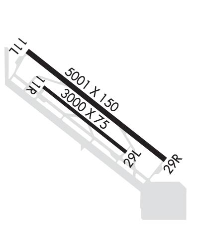
| Lat: N 3348.2 Long: W 11820.4 Elev: 103 Var: -14 Longest Runway: 5001 | ||
| Dept. ATIS: 125.6 Arr. ATIS: 125.6 Ground: 120.9 Tower: 124.0/133.07 | ||
| ||||||||||||||||||||||||||||||||||||||||||||
| ||||||||||||||||||||||||||||||||||||||||||||
| ||||||||||||||||||||||||||||||||||||||||||||
| ||||||||||||||||||||||||||||||||||||||||||||
| ||||||||||||||||||||||||||||||||||||||||||||
| Rwy | Rwy | |||||||
| 5001x150 | 4460' | 5001x150 | 4461' | 111.90 - 294° | ||||
| 3000x75 | 3000' | 3000x75 | 3000' | |||||
| Runway ID | Single Wheel | Double Wheel | Double Tandem Wheel | Dual Double Wheel |
| 11L/29R | 30,000 | 50,000 | 90,000 | N/A |
| 11R/29L | 28,000 | N/A | N/A | N/A |
| H1 | N/A | N/A | N/A | N/A |
| These numbers are Advisory and are not limits. The Airport Manager should have more accurate Weight Limits | ||||
 Airport Diagram might not be current. | |
| Facility Name: | ZAMPERINI FLD |
| City Name: | TORRANCE |
| County: | LOS ANGELES |
| State abbrev: | CA |
| State Name: | CALIFORNIA |
| Ownership: | PUBLICLY OWNED |
| Use: | OPEN TO THE PUBLIC |
| Owner's Name: | CITY OF TORRANCE |
| Address: | 3031 TORRANCE BLVD |
| TORRANCE, CA 90503 | |
| Owner's Phone: | 310-784-7900 |
| Manager's Name: | RAFAEL HERRERA |
| Address: | CITY OF TORRANCE, 3301 AIRPORT DRIVE |
| TORRANCE, CA 90505 | |
| Phone: | 310-784-7914 |
| FAA Region: | WESTERN-PACIFIC |
| FAA Field Office: | LAX |

| Date | Sunrise | Sunset |
|---|---|---|
| 09/24/21 Friday | 6:43 | 18:47 |
| 09/25/21 Saturday | 6:43 | 18:46 |
| 09/26/21 Sunday | 6:44 | 18:45 |
| 09/27/21 Monday | 6:45 | 18:43 |
| 09/28/21 Tuesday | 6:46 | 18:42 |
| 09/29/21 Wednesday | 6:46 | 18:41 |
| 09/30/21 Thursday | 6:47 | 18:39 |
| 10/01/21 Friday | 6:48 | 18:38 |
| 10/02/21 Saturday | 6:48 | 18:37 |
| 10/03/21 Sunday | 6:49 | 18:35 |
| 10/04/21 Monday | 6:50 | 18:34 |
| 10/05/21 Tuesday | 6:51 | 18:32 |
| 10/06/21 Wednesday | 6:51 | 18:31 |
| 10/07/21 Thursday | 6:52 | 18:30 |
| Airport Attendance Schedule | 7 Days A Week 0600-2200 |
| Airport Status | OPERATIONAL (This Status can change at any time - please check NOTAMS) |
| Airport Lighting Schedule | WHEN ATCT CLSD ACTVT MALSR RY 29R - CTAF; MIRL RY 11L/29R SS-SR; MIRL RY 11R/29L 0600-2000; ACTVT HELIPAD PERIMETER LGTS - 24 HRS - CTAF. |
| Airport Storage Available | Tie Downs |
| Extra Services Available | Avionics, Charter, Flight Instruction, Aircraft Rental, Aircraft Sales |
| Wind Indicator | YES - (lighted) |
| Control Tower | YES |
| CTAF Frequency | 124.000 |
| Unicom Frequency | 122.950 |
| Rotating Beacon Color | CLEAR-GREEN (Light Land Airport) |
| Segmented Circle | YES |
| Landing Fee | NO |
| Airport Inspected | STATE - performed by STATE AERONAUTICAL PERSONNEL |
| Inspection Date | 09/20/2016 |
| Type of Fuel Available | Grade 100LL; -10FUEL AVBL 0700-2000. |
| Airframe Repair Service | MAJOR |
| Power Plant Repair Service | MAJOR |
| Latitude | N3348.2 |
| Longitude | W11820.4 (ESTIMATED) |
| Arpt Elevation | 103ft (SURVEYED) |
| Magnetic Variation | 14E |
| 3 miles SW | of TORRANCE |
| Traffic Pattern Altitude | |
| Sectional Chart | LOS ANGELES |
| Operations (Reported) | Yearly | Avg. Daily |
|---|---|---|
| General Aviation Transient | 63040 | 173 |
| General Aviation Local | 55144 | 151 |
| Air Taxi | 348 | 1 |
| Commerical | 28 | 0 |
| Commuter | 0 | 0 |
| Military | 474 | 1 |
| Aircraft based on Field | |
|---|---|
| General Aviation Singles | 247 |
| General Aviation Multi | 23 |
| Jet Aircraft | 1 |
| General Aviation Helicopters | 5 |
| Military Aircraft | 0 |
| Gliders | 3 |
| Ultralights | 0 |
| FSS on field | NO |
| FSS tie-in | HAWTHORNE |
| FSS Phone | 1-800-WX-BRIEF |
| Who issues Notams | TOA |
| Notam D service at airport | YES |
| ARTCC Name | LOS ANGELES |
| Airport Certification | |
| Aircraft Rescue & Firefighting Index | None |
| Airport of Entry | No |
| Custom Landing Rights | No |
| Joint Civil/Military | No |
| Military Landing rights | YES |
| NATIONAL PLAN OF INTEGRATED AIRPORT SYSTEMS (NPIAS) |
| ASSURANCES PURSUANT TO TITLE VI, CIVIL RIGHTS ACT OF 1964 |
| GRANT AGREEMENT HAS EXPIRED; HOWEVER, AGREEMENT REMAINS IN EFFECT FOR THIS FACILITY AS LONG AS IT IS PUBLIC USE. |
| NUMEROUS FLOCKS OF BIRDS ON AND INVOF ARPT. |
| FOR CD WHEN ATCT CLSD CTC SOCAL APCH AT 800-448-3724. |
| TGL-STOP/GO LNDG & LOW APCH OPNS & TAXI-BACK OPNS LTD TO 0800-2000 (TAXI-BACK UNTIL 2200) WKDAYS & 1000-1700 SAT. NO TGL-STOP/GO LNDG & LOW APCH OPNS & TAXI-BACK OPNS ON SUN & HOLS. ARPT CLSD TO DEP 2200-0700 WKDAYS & 2200-0800 WKENDS & HOLS. |
| NO MULTI-ENGINE SIMULATED ENGINE-OUT PROCS AUTH IN TFC PAT. RY 11R/29L CLSD 2000-0700. |
| NOISE SENSITIVE AREA ALL QUADS. FOR NOISE ABATEMENT PROCS INFO CTC ARPT NOISE ABATEMENT (310) 784-7950. CERTAIN TBJT ACFT PERMLY EXCLDD. |
| TWYS CROSS APCH ZONE BOTH ENDS RWY 11R/29L OBSERVE TWY HOLD LINES. |
| BE ALERT TO FARM EQUIPMENT OPERG NEAR ALL RWYS AND TWYS. |
Airport Communications & Frequencies:
| |||||||||||||||||||||||||||||||||||
| Runway: 11L | Runway: 29R | ||
| Mag heading: | 114° | Mag heading: | 294° |
| Rwy Slope: | .28% Up | Rwy Slope: | -.28% Down |
| Approach: | Approach: | ILS/DME | |
| Pattern: | Left Traffic | Pattern: | Right Traffic |
| Markings: | PRECISION INSTRUMENT | Markings: | PRECISION INSTRUMENT |
| Marking Condition: | FAIR | Marking Condition: | FAIR |
| Arresting Dev: | Arresting Dev: | ||
| Lat & Long: | N3348.5 W11820.7 | Lat. & Long.: | N3348.0 W11820.0 |
| Elev: | 83.0 ft. MSL | Elev: | 96.8 ft. MSL |
| TCH: | 10 ft. AGL | TCH: | 11 ft. AGL |
| Visual Glide Path: | 3.50 degrees | Visual Glide Path: | 4.00 degrees |
| Displaced Threshold: | 541 feet | Displaced Threshold: | 540 feet |
| Touchdown Zone: | YES | Touchdown Zone: | YES |
| Touchdown Elev.: | 96.1 feet | Touchdown Elev.: | 97.0 feet |
| Visual Glide Slope: | 2-Box VASI on LEFT side of Runway | Visual Glide Slope: | 4-BOX VASI ON LEFT SIDE OF RUNWAY |
| RVR Equipment: | RVR Equipment: | ||
| RVV Equipment: | NO | RVV Equipment: | NO |
| Approach Lights: | Approach Lights: | MALSR - 1,400 foot medium intensity approach lighting system with runway alignment indicator lights | |
| REIL: | NO | REIL: | NO |
| Centerline Lights: | NO | Centerline Lights: | NO |
| Touchdown lights: | NO | Touchdown lights: | NO |
| Runway Category: | Runway with a Non-precision Approach having visibility minimums greater than 3/4 mile | Runway Category: | Precision Instrument Runway |
| Declared Distances: | Declared Distances: | ||
| Obstructions: | TREES | Obstructions: | BLDG |
| Marked: | NOT Marked/Lighted | Marked: | NOT Marked/Lighted |
| Clearance slope: | 14:1; RWY 11L APCH RATIO TO DSPLCD THR 35:1; | Clearance slope: | 12:1; APCH RATIO 46:1 TO DSPLCD THLD. |
| Obstruction height: | 35 feet AGL | Obstruction height: | 22 feet AGL |
| Dist. from runway: | 690 feet | Dist. from runway: | 475 feet |
| Centerline offset: | Centerline offset: | 530 feet left of centerline | |
| Comments: | Comments: | +9 FT MALSR BLDG 190 FT FROM E OR 440 FT RIGHT. |
| Runway: 11R | Runway: 29L | ||
| Mag heading: | 114° | Mag heading: | 294° |
| Rwy Slope: | .23% Up | Rwy Slope: | -.23% Down |
| Approach: | Approach: | ||
| Pattern: | Right Traffic | Pattern: | Left Traffic |
| Markings: | BASIC | Markings: | BASIC |
| Marking Condition: | FAIR | Marking Condition: | FAIR |
| Arresting Dev: | Arresting Dev: | ||
| Lat & Long: | N3348.3 W11820.6 | Lat. & Long.: | N3348.0 W11820.2 |
| Elev: | 96.3 ft. MSL | Elev: | 103.2 ft. MSL |
| TCH: | TCH: | 25 ft. AGL | |
| Visual Glide Path: | Visual Glide Path: | 4.00 degrees | |
| Displaced Threshold: | No | Displaced Threshold: | No |
| Touchdown Zone: | YES | Touchdown Zone: | YES |
| Touchdown Elev.: | 103.2 feet | Touchdown Elev.: | 103.2 feet |
| Visual Glide Slope: | Visual Glide Slope: | 2-Box VASI on LEFT side of Runway | |
| RVR Equipment: | RVR Equipment: | ||
| RVV Equipment: | NO | RVV Equipment: | NO |
| Approach Lights: | Approach Lights: | ||
| REIL: | NO | REIL: | YES |
| Centerline Lights: | NO | Centerline Lights: | NO |
| Touchdown lights: | NO | Touchdown lights: | NO |
| Runway Category: | Runway with a Visual Approach | Runway Category: | Runway with a Visual Approach |
| Declared Distances: | Declared Distances: | ||
| Obstructions: | Obstructions: | BLDG | |
| Marked: | Marked: | LIGHTED | |
| Clearance slope: | 50:1 | Clearance slope: | 46:1 |
| Obstruction height: | Obstruction height: | 26 feet AGL | |
| Dist. from runway: | Dist. from runway: | 1400 feet | |
| Centerline offset: | Centerline offset: | 100 feet left of centerline | |
| Comments: | Comments: |
Thanks for using FltPlan.com
all rights reserved © 1999-2021 by Flight Plan LLC