
| SYRACUSE HANCOCK INTL SYRACUSE NY |
| |
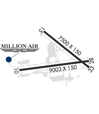
| Lat: N 4306.7 Long: W 07606.4 Elev: 421 Var: +13 Longest Runway: 9003 | ||
| Clr Del: 125.05 Dept. ATIS: 124.22 Arr. ATIS: 124.22 Ground: 121.7 Tower: 120.3 | ||
| |||||||||||||||||||||||||||||||||||||||||||||||||||||||||||||||||||||
| |||||||||||||||||||||||||||||||||||||||||||||||||||||||||||||||||||||
| |||||||||||||||||||||||||||||||||||||||||||||||||||||||||||||||||||||
| |||||||||||||||||||||||||||||||||||||||||||||||||||||||||||||||||||||
| Rwy | Rwy | |||||||
| 9003x150 | 9003' | 109.90 - 100° | 9003x150 | 9003' | 109.90 - 280° | |||
| 7500x150 | 7500' | 7500x150 | 7500' | |||||
| Runway ID | Single Wheel | Double Wheel | Double Tandem Wheel | Dual Double Wheel |
| 10/28 | 115,000 | 156,000 | 257,000 | N/A |
| 15/33 | 115,000 | 156,000 | 257,000 | N/A |
| These numbers are Advisory and are not limits. The Airport Manager should have more accurate Weight Limits | ||||
 Airport Diagram might not be current. | |
| Facility Name: | SYRACUSE HANCOCK INTL |
| City Name: | SYRACUSE |
| County: | ONONDAGA |
| State abbrev: | NY |
| State Name: | NEW YORK |
| Ownership: | PUBLICLY OWNED |
| Use: | OPEN TO THE PUBLIC |
| Owner's Name: | CITY OF SYRACUSE |
| Address: | CITY HALL |
| SYRACUSE, NY 13212 | |
| Owner's Phone: | 315-448-8805 |
| Manager's Name: | JASON TERRERI |
| Address: | 1000 COL EILEEN COLLINS BLVD |
| SYRACUSE, NY 13212 | |
| Phone: | 315-454-3263 |
| FAA Region: | EASTERN |
| FAA Field Office: | NYC |
| Date | Sunrise | Sunset |
|---|---|---|
| 09/24/21 Friday | 6:54 | 18:59 |
| 09/25/21 Saturday | 6:55 | 18:57 |
| 09/26/21 Sunday | 6:56 | 18:55 |
| 09/27/21 Monday | 6:57 | 18:53 |
| 09/28/21 Tuesday | 6:58 | 18:51 |
| 09/29/21 Wednesday | 6:59 | 18:50 |
| 09/30/21 Thursday | 7:00 | 18:48 |
| 10/01/21 Friday | 7:01 | 18:46 |
| 10/02/21 Saturday | 7:03 | 18:44 |
| 10/03/21 Sunday | 7:04 | 18:43 |
| 10/04/21 Monday | 7:05 | 18:41 |
| 10/05/21 Tuesday | 7:06 | 18:39 |
| 10/06/21 Wednesday | 7:07 | 18:37 |
| 10/07/21 Thursday | 7:08 | 18:36 |
| Airport Attendance Schedule | CONTINUOUS |
| Airport Status | OPERATIONAL (This Status can change at any time - please check NOTAMS) |
| Airport Lighting Schedule | SS-SR |
| Airport Storage Available | Tie Downs, Hanger |
| Extra Services Available | Air Freight, Avionics, Cargo Handling, Charter, Flight Instruction, Aircraft Rental, Aircraft Sales |
| Wind Indicator | YES - (lighted) |
| Control Tower | YES |
| CTAF Frequency | |
| Unicom Frequency | 122.950 |
| Rotating Beacon Color | CLEAR-GREEN (Light Land Airport) |
| Segmented Circle | NO |
| Landing Fee | NO |
| Airport Inspected | FEDERAL - performed by FAA AIRPORTS FIELD PERSONNEL |
| Inspection Date | 05/25/2021 |
| Type of Fuel Available | Grade 100LL, JET A (freeze point -40C) |
| Airframe Repair Service | MAJOR |
| Power Plant Repair Service | MAJOR |
| Latitude | N4306.7 |
| Longitude | W07606.4 (ESTIMATED) |
| Arpt Elevation | 421ft (SURVEYED) |
| Magnetic Variation | 13W |
| 4 miles NE | of SYRACUSE |
| Traffic Pattern Altitude | |
| Sectional Chart | NEW YORK |
| Operations (Reported) | Yearly | Avg. Daily |
|---|---|---|
| General Aviation Transient | 12280 | 34 |
| General Aviation Local | 4118 | 11 |
| Air Taxi | 6877 | 19 |
| Commerical | 15624 | 43 |
| Commuter | 0 | 0 |
| Military | 8478 | 23 |
| Aircraft based on Field | |
|---|---|
| General Aviation Singles | 25 |
| General Aviation Multi | 6 |
| Jet Aircraft | 7 |
| General Aviation Helicopters | 2 |
| Military Aircraft | 9 |
| Gliders | 0 |
| Ultralights | 0 |
| FSS on field | NO |
| FSS tie-in | BUFFALO |
| FSS Phone | 1-800-WX-BRIEF |
| Who issues Notams | SYR |
| Notam D service at airport | YES |
| ARTCC Name | BOSTON |
| Airport Certification | AIRPORT RECEIVING SCHEDULED AIR CARRIER SERVICE FROM CARRIERS CERTIFICATED BY THE CIVIL AERONAUTICS BOARD |
| Aircraft Rescue & Firefighting Index | AIRPORT HAS A CERTIFICATE UNDER CFR PART 139 |
| Airport of Entry | No |
| Custom Landing Rights | YES |
| Joint Civil/Military | No |
| Military Landing rights | YES |
| NATIONAL PLAN OF INTEGRATED AIRPORT SYSTEMS (NPIAS) |
| GRANT AGREEMENTS UNDER FAAP/ADAP/AIP |
| SURPLUS PROPERTY AGREEMENT UNDER PUBLIC LAW 289 |
| ASSURANCES PURSUANT TO TITLE VI, CIVIL RIGHTS ACT OF 1964 |
| NO CHARTER OPER THRU PASSENGER TERMINAL BLDG WITHOUT PRIOR PERMISSION. |
| FIELD CONDITION REPORTS RECORDING AVAILABLE CALL 315-455-3444. |
| HVY ACFT CTC ARPT COMMISSIONER FOR PRK AVBL AT C315-455-3263. LIMITED METRO AVAIL AT DSN 243-2185. C315-233-2185 OR CTC OWS DSN 576-9755/9702. ALL TRAN ACFT REQ NOISE ABATEMENT BRIEFING. |
| MILITARY: COMMUNICATIONS - ANG - OPS - 140.425 379.5 REMARKS: (COBRA OPS) CTC ANG OPS 15 MIN PRIOR TO ARR. |
| RSTD: TWY J AND P SOUTH OF TWY Y CLSD TO CIV OPS. |
| CAUTION: TWY J AND P SOUTH OF TWY Y AND ANG RAMP HAVE UNCTL VEH AND EQPT TFC. |
| MILITARY: ANG: OPR 1030-2100Z++ MON-THUR EXC HOL. PPR TRANS ACFT OFFL BUS ONLY. AFLD MGR DSN 243-2398, C315-233-2398, AFT DUTY HR CTC C315-233-2398. PPR REQ FOR ALL TRAN ACFT DUE LTD TRANS SVC. NTFY AFLD MGR OF ETA DELAY OVER 30 MIN OR MSN CNL IS RQR. |
| NOISE ABATEMENT PROCEDURES IN EFFECT. |
| ANG: HVY ACFT CTC ARPT COMMISSIONER FOR PRK AVBL AT C315-455-3666. ALL TRAN ACFT RQR NS ABTMT BRIEFING. |
| UAS OPERATE WITHIN THE CONFINES OF THE SYRACUSE CLASS C, TIMES VARY. |
| UAS OPS IN SYRACUSE APCH/DEP AIRSPACE WILL BE CONTROLLED BY SYR ATC AT ALL TIMES. |
| NON-STD MKG ON MIL RAMP. |
| DEER/COYOTE/BIRDS ON INVOF ARPT. |
| NO JET ENGINE MAINT RUNS ABOVE IDLE BTWN 2300-0600. |
| NO TSNT ACFT PARKING ON MAIN TERMINAL RAMP. |
| DIRECT CUSTOM NOTIFICATION IS REQUIRED. HOURS OF NOTIFICATION ARE MON-SAT 0800-1700. ARRIVALS OUTSIDE OF THESE HRS MUST MAKE ARRANGEMENTS DURING REGULAR WORK HRS; CALL 315-455-2271. |
Airport Communications & Frequencies:
| |||||||||||||||||||||||||||||||||||||||||||||
| Runway: 10 | Runway: 28 | ||
| Mag heading: | 100° | Mag heading: | 280° |
| Rwy Slope: | -.21% Down | Rwy Slope: | .21% Up |
| Approach: | ILS/DME | Approach: | ILS/DME |
| Pattern: | Left Traffic | Pattern: | Left Traffic |
| Markings: | PRECISION INSTRUMENT | Markings: | PRECISION INSTRUMENT |
| Marking Condition: | GOOD | Marking Condition: | GOOD |
| Arresting Dev: | Arresting Dev: | ||
| Lat & Long: | N4306.5 W07607.6 | Lat. & Long.: | N4306.6 W07605.5 |
| Elev: | 419.2 ft. MSL | Elev: | 400.4 ft. MSL |
| TCH: | 55 ft. AGL | TCH: | 60 ft. AGL |
| Visual Glide Path: | 3.00 degrees | Visual Glide Path: | 3.00 degrees |
| Displaced Threshold: | No | Displaced Threshold: | No |
| Touchdown Zone: | YES | Touchdown Zone: | YES |
| Touchdown Elev.: | 421.4 feet | Touchdown Elev.: | 412.7 feet |
| Visual Glide Slope: | 4-BOX VASI ON LEFT SIDE OF RUNWAY | Visual Glide Slope: | 4-Light PAPI on RIGHT side of Runway |
| RVR Equipment: | TOUCHDOWN-MIDFIELD-ROLLOUT | RVR Equipment: | TOUCHDOWN-MIDFIELD-ROLLOUT; TOUCHDOWN RVR SENSOR SHARED BY RY 33. |
| RVV Equipment: | NO | RVV Equipment: | NO |
| Approach Lights: | MALSR - 1,400 foot medium intensity approach lighting system with runway alignment indicator lights | Approach Lights: | ALSF2 - standard 2,400 foot high intensity approach lighting system with sequenced flashers, Category II or III |
| REIL: | NO | REIL: | NO |
| Centerline Lights: | YES | Centerline Lights: | YES |
| Touchdown lights: | NO | Touchdown lights: | YES |
| Runway Category: | Precision Instrument Runway | Runway Category: | Precision Instrument Runway |
| Declared Distances: | TORA:9003' TODA:9003' ASDA:9003' LDA:9003' | Declared Distances: | TORA:9003' TODA:9003' ASDA:9003' LDA:9003' |
| Obstructions: | TREES | Obstructions: | TREES |
| Marked: | NOT Marked/Lighted | Marked: | NOT Marked/Lighted |
| Clearance slope: | 37:1 | Clearance slope: | 34:1 |
| Obstruction height: | 64 feet AGL | Obstruction height: | 80 feet AGL |
| Dist. from runway: | 2609 feet | Dist. from runway: | 2924 feet |
| Centerline offset: | 686 right of centerline | Centerline offset: | 287 feet left of centerline |
| Comments: | Comments: |
| Runway: 15 | Runway: 33 | ||
| Mag heading: | 147° | Mag heading: | 327° |
| Rwy Slope: | -.18% Down | Rwy Slope: | .18% Up |
| Approach: | Approach: | ||
| Pattern: | Left Traffic | Pattern: | Left Traffic |
| Markings: | NONPRECISION INSTRUMENT | Markings: | NONSTANDARD |
| Marking Condition: | GOOD | Marking Condition: | GOOD; NSTD MARKINGS; AIMING POINT MARKINGS ARE 1340 FT FM APCH END RY. |
| Arresting Dev: | Arresting Dev: | ||
| Lat & Long: | N4307.3 W07606.8 | Lat. & Long.: | N4306.4 W07605.6 |
| Elev: | 415.4 ft. MSL | Elev: | 401.7 ft. MSL |
| TCH: | 53 ft. AGL | TCH: | 53 ft. AGL |
| Visual Glide Path: | 3.00 degrees | Visual Glide Path: | 3.00 degrees |
| Displaced Threshold: | No | Displaced Threshold: | No |
| Touchdown Zone: | YES | Touchdown Zone: | YES |
| Touchdown Elev.: | 416.8 feet | Touchdown Elev.: | 409.3 feet |
| Visual Glide Slope: | 4-BOX VASI ON LEFT SIDE OF RUNWAY | Visual Glide Slope: | 4-Light PAPI on LEFT side of Runway |
| RVR Equipment: | ROLLOUT | RVR Equipment: | TOUCHDOWN |
| RVV Equipment: | NO | RVV Equipment: | NO |
| Approach Lights: | MALS - 1,400 foot medium intensity approach lighting system | Approach Lights: | |
| REIL: | NO | REIL: | NO |
| Centerline Lights: | YES | Centerline Lights: | YES |
| Touchdown lights: | NO | Touchdown lights: | NO |
| Runway Category: | D | Runway Category: | Runway with a Non-precision Approach having visibility minimums greater than 3/4 mile |
| Declared Distances: | TORA:7500' TODA:7500' ASDA:7500' LDA:7500' | Declared Distances: | TORA:7500' TODA:7500' ASDA:7500' LDA:7500' |
| Obstructions: | TREES | Obstructions: | TREE |
| Marked: | NOT Marked/Lighted | Marked: | NOT Marked/Lighted |
| Clearance slope: | 24:1 | Clearance slope: | 18:1 |
| Obstruction height: | 51 feet AGL | Obstruction height: | 34 feet AGL |
| Dist. from runway: | 1440 feet | Dist. from runway: | 840 feet |
| Centerline offset: | 380 left of centerline | Centerline offset: | 520 feet left of centerline |
| Comments: | Comments: |
Thanks for using FltPlan.com
all rights reserved © 1999-2021 by Flight Plan LLC


