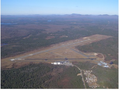
| ADIRONDACK RGNL SARANAC LAKE NY |
| |
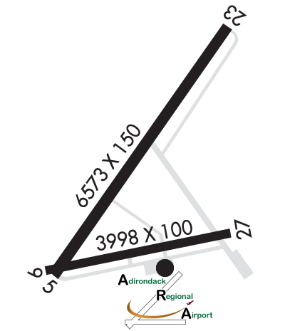
| Lat: N 4423.1 Long: W 07412.4 Elev: 1663 Var: +14 Longest Runway: 6573 | ||
| AWOS: 124.17 CTAF: 123.0 | ||
| ||||||||||||||||||||||||||||||||||||||||||||||||||||||||||||||||||||
| ||||||||||||||||||||||||||||||||||||||||||||||||||||||||||||||||||||
| ||||||||||||||||||||||||||||||||||||||||||||||||||||||||||||||||||||
| Rwy | Rwy | |||||||
| 6573x150 | 6573' | 6573x150 | 6573' | 108.90 - 228° | ||||
| 3997x100 | 3997' | 3997x100 | 3597' | |||||
| Runway ID | Single Wheel | Double Wheel | Double Tandem Wheel | Dual Double Wheel |
| 05/23 | 40,000 | 73,000 | 115,000 | N/A |
| 09/27 | 40,000 | 73,000 | 115,000 | N/A |
| These numbers are Advisory and are not limits. The Airport Manager should have more accurate Weight Limits | ||||
 Airport Diagram might not be current. | |
| Facility Name: | ADIRONDACK RGNL |
| City Name: | SARANAC LAKE |
| County: | FRANKLIN |
| State abbrev: | NY |
| State Name: | NEW YORK |
| Ownership: | PUBLICLY OWNED |
| Use: | OPEN TO THE PUBLIC |
| Owner's Name: | TOWN OF HARRIETSTOWN |
| Address: | 39 MAIN STREET |
| SARANAC LAKE, NY 12983 | |
| Owner's Phone: | 518-891-1470 |
| Manager's Name: | COREY HURWITCH |
| Address: | 96 AIRPORT ROAD |
| SARANAC LAKE, NY 12983 | |
| Phone: | 518-891-4600 |
| FAA Region: | EASTERN |
| FAA Field Office: | NYC |
| Date | Sunrise | Sunset |
|---|---|---|
| 05/05/26 Tuesday | 5:42 | 20:05 |
| 05/06/26 Wednesday | 5:41 | 20:07 |
| 05/07/26 Thursday | 5:40 | 20:08 |
| 05/08/26 Friday | 5:38 | 20:09 |
| 05/09/26 Saturday | 5:37 | 20:10 |
| 05/10/26 Sunday | 5:36 | 20:11 |
| 05/11/26 Monday | 5:35 | 20:13 |
| 05/12/26 Tuesday | 5:33 | 20:14 |
| 05/13/26 Wednesday | 5:32 | 20:15 |
| 05/14/26 Thursday | 5:31 | 20:16 |
| 05/15/26 Friday | 5:30 | 20:17 |
| 05/16/26 Saturday | 5:29 | 20:18 |
| 05/17/26 Sunday | 5:28 | 20:19 |
| 05/18/26 Monday | 5:27 | 20:20 |
| Airport Attendance Schedule | MAY-OCT 7 Days A Week 0600-2100, NOV-APR 7 Days A Week 0600-2000; FOR ARPT ATTENDANT AFTER HRS CALL 518-637-7329. |
| Airport Status | OPERATIONAL (This Status can change at any time - please check NOTAMS) |
| Airport Lighting Schedule | ACTVT MALSR RWY 23; HIRL RWY 05/23, MIRL RWY 09/27 & TWY LGTS - CTAF. PAPI RWY 05 OPR CONSLY. |
| Airport Storage Available | Tie Downs, Hanger |
| Extra Services Available | Charter |
| Wind Indicator | YES - (lighted) |
| Control Tower | NO |
| CTAF Frequency | 123.000 |
| Unicom Frequency | 123.000 |
| Rotating Beacon Color | WG |
| Segmented Circle | NO |
| Landing Fee | YES |
| Airport Inspected | FEDERAL - performed by FAA AIRPORTS FIELD PERSONNEL |
| Inspection Date | 05/21/2025 |
| Type of Fuel Available | Grade 100LL, JET A (freeze point -40C) |
| Airframe Repair Service | MAJOR |
| Power Plant Repair Service | MAJOR |
| Latitude | N4423.1 |
| Longitude | W07412.4 (ESTIMATED) |
| Arpt Elevation | 1662ft (SURVEYED) |
| Magnetic Variation | 14W |
| 4 miles NW | of SARANAC LAKE |
| Traffic Pattern Altitude | |
| Sectional Chart | MONTREAL |
| Operations (Reported) | Yearly | Avg. Daily |
|---|---|---|
| General Aviation Transient | 0 | 0 |
| General Aviation Local | 0 | 0 |
| Air Taxi | 0 | 0 |
| Commerical | 0 | 0 |
| Commuter | 0 | 0 |
| Military | 0 | 0 |
| Aircraft based on Field | |
|---|---|
| General Aviation Singles | 0 |
| General Aviation Multi | 0 |
| Jet Aircraft | 0 |
| General Aviation Helicopters | 0 |
| Military Aircraft | 0 |
| Gliders | 0 |
| Ultralights | 0 |
| FSS on field | NO |
| FSS tie-in | BURLINGTON |
| FSS Phone | 1-800-WX-BRIEF |
| Who issues Notams | SLK |
| Notam D service at airport | YES |
| ARTCC Name | BOSTON |
| Airport Certification | AIRPORT RECEIVING SCHEDULED AIR CARRIER SERVICE FROM CARRIERS CERTIFICATED BY THE CIVIL AERONAUTICS BOARD; PPR 48 HR FOR UNSKED ACR OPNS WITH MORE THAN 30 PSGR SEATS CALL AMGR 518-891-4600 EXT. 106. INDEX "B" COVERAGE IS PROVIDED. |
| Aircraft Rescue & Firefighting Index | AIRPORT HAS A CERTIFICATE UNDER CFR PART 139 |
| Airport of Entry | No |
| Custom Landing Rights | YES |
| Joint Civil/Military | No |
| Military Landing rights | YES |
| NATIONAL PLAN OF INTEGRATED AIRPORT SYSTEMS (NPIAS) |
| GRANT AGREEMENTS UNDER FAAP/ADAP/AIP |
| ASSURANCES PURSUANT TO TITLE VI, CIVIL RIGHTS ACT OF 1964 |
| AGREEMENT UNDER DLAND OR DCLA HAS EXPIRED. |
| RWY/TWY/APRON CONDS NOT MNT OUTSIDE OF NML ATND HRS. |
| TWY B UNAVBL TO ACFT WITH WINGSPAN 79 FT & ABV. |
| COLD TEMPERATURE AIRPORT. ALTITUDE CORRECTION REQUIRED AT OR BELOW -32C. |
| FOR CD IF UNA TO CTC ON FREQ, CTC BOSTON ARTCC AT 603-879-6859. |
| ALL SFCS WORK IN PROG; GRASS CUTTING APR THRU OCT. |
| RWY 05/2 3 PCR VALUE: 363/F/B/X/T |
| RWY 09/2 7 PCR VALUE: 349/F/A/X/T |
Airport Communications & Frequencies:
| |||||||||
| Runway: 05 | Runway: 23 | ||
| Mag heading: | 49° | Mag heading: | 229° |
| Rwy Slope: | .34% Up | Rwy Slope: | -.34% Down |
| Approach: | Approach: | ILS | |
| Pattern: | Left Traffic | Pattern: | Left Traffic |
| Markings: | NONPRECISION INSTRUMENT | Markings: | PRECISION INSTRUMENT |
| Marking Condition: | FAIR | Marking Condition: | FAIR |
| Arresting Dev: | Arresting Dev: | ||
| Lat & Long: | N4422.8 W07412.8 | Lat. & Long.: | N4423.7 W07411.9 |
| Elev: | 1640.0 ft. MSL | Elev: | 1662.5 ft. MSL |
| TCH: | 35 ft. AGL | TCH: | |
| Visual Glide Path: | 3.00 degrees | Visual Glide Path: | |
| Displaced Threshold: | No | Displaced Threshold: | No |
| Touchdown Zone: | YES | Touchdown Zone: | YES |
| Touchdown Elev.: | 1653.9 feet | Touchdown Elev.: | 1662.6 feet |
| Visual Glide Slope: | 4-Light PAPI on LEFT side of Runway | Visual Glide Slope: | |
| RVR Equipment: | RVR Equipment: | ||
| RVV Equipment: | NO | RVV Equipment: | NO |
| Approach Lights: | Approach Lights: | MALSR - 1,400 foot medium intensity approach lighting system with runway alignment indicator lights | |
| REIL: | NO | REIL: | NO |
| Centerline Lights: | NO | Centerline Lights: | NO |
| Touchdown lights: | NO | Touchdown lights: | NO |
| Runway Category: | Runway with a Non-precision Approach having visibility minimums greater than 3/4 mile | Runway Category: | Precision Instrument Runway |
| Declared Distances: | TORA:6573' TODA:6573' ASDA:6573' LDA:6573' | Declared Distances: | TORA:6573' TODA:6573' ASDA:6333' LDA:6333' |
| Obstructions: | TREES | Obstructions: | TREES |
| Marked: | NOT Marked/Lighted | Marked: | NOT Marked/Lighted |
| Clearance slope: | 10:1 | Clearance slope: | 26:1 |
| Obstruction height: | 18 feet AGL | Obstruction height: | 7 feet AGL |
| Dist. from runway: | 387 feet | Dist. from runway: | 385 feet |
| Centerline offset: | 387 left of centerline | Centerline offset: | 532 feet right of centerline |
| Comments: | Comments: |
| Runway: 09 | Runway: 27 | ||
| Mag heading: | 93° | Mag heading: | 273° |
| Rwy Slope: | -.01% Down | Rwy Slope: | .01% Up |
| Approach: | Approach: | ||
| Pattern: | Left Traffic | Pattern: | Left Traffic |
| Markings: | NONSTANDARD | Markings: | NONPRECISION INSTRUMENT |
| Marking Condition: | GOOD; NSTD MKGS; THLD MKGS 400 FT FM RY END. | Marking Condition: | GOOD |
| Arresting Dev: | Arresting Dev: | ||
| Lat & Long: | N4422.8 W07412.8 | Lat. & Long.: | N4423.0 W07411.9 |
| Elev: | 1638.8 ft. MSL | Elev: | 1638.3 ft. MSL |
| TCH: | TCH: | ||
| Visual Glide Path: | Visual Glide Path: | ||
| Displaced Threshold: | No | Displaced Threshold: | 400 feet |
| Touchdown Zone: | YES | Touchdown Zone: | YES |
| Touchdown Elev.: | 1643.5 feet | Touchdown Elev.: | 1643.5 feet |
| Visual Glide Slope: | Visual Glide Slope: | ||
| RVR Equipment: | RVR Equipment: | ||
| RVV Equipment: | NO | RVV Equipment: | NO |
| Approach Lights: | Approach Lights: | ||
| REIL: | NO | REIL: | NO |
| Centerline Lights: | NO | Centerline Lights: | NO |
| Touchdown lights: | NO | Touchdown lights: | NO |
| Runway Category: | Runway with a Non-precision Approach having visibility minimums greater than 3/4 mile | Runway Category: | Runway with a Visual Approach |
| Declared Distances: | TORA:3997' TODA:3997' ASDA:3997' LDA:3997' | Declared Distances: | TORA:3997' TODA:3997' ASDA:3997' LDA:3597' |
| Obstructions: | TREES | Obstructions: | TREES |
| Marked: | NOT Marked/Lighted | Marked: | NOT Marked/Lighted |
| Clearance slope: | Clearance slope: | 10:1 | |
| Obstruction height: | 27 feet AGL | Obstruction height: | 18 feet AGL |
| Dist. from runway: | 214 feet | Dist. from runway: | 387 feet |
| Centerline offset: | 252 left of centerline | Centerline offset: | 56 feet left of centerline |
| Comments: | Comments: |
Thanks for using FltPlan.com
all rights reserved © 1999-2026 by Flight Plan LLC