| AUBURN MUNI AUBURN WA |
| |
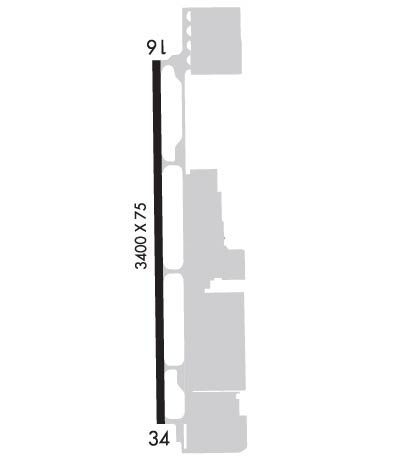
| Lat: N 4719.7 Long: W 12213.6 Elev: 63 Var: -18 Longest Runway: 3842 | ||
| Clr Del: 123.85 CTAF: 122.8 | ||
| |||||||||||||||||||||||
| |||||||||||||||||||||||
| Rwy | Rwy | |||||||
| 3842x75 | 3642' | 3842x75 | 3601' | |||||
| Runway ID | Single Wheel | Double Wheel | Double Tandem Wheel | Dual Double Wheel |
| 16/34 | 12,500 | N/A | N/A | N/A |
| These numbers are Advisory and are not limits. The Airport Manager should have more accurate Weight Limits | ||||
 Airport Diagram might not be current. | |
| Facility Name: | AUBURN MUNI |
| City Name: | AUBURN |
| County: | KING |
| State abbrev: | WA |
| State Name: | WASHINGTON |
| Ownership: | PUBLICLY OWNED |
| Use: | OPEN TO THE PUBLIC |
| Owner's Name: | CITY OF AUBURN |
| Address: | 25 WEST MAIN STREET |
| AUBURN, WA 98001 | |
| Owner's Phone: | (253) 931-3010 |
| Manager's Name: | TIM MENSONIDES |
| Address: | 2143 E ST. NE, SUITE #1 |
| AUBURN, WA 98002 | |
| Phone: | (253) 333-6821 |
| FAA Region: | NORTHWEST MOUNTAIN |
| FAA Field Office: | SEA |

| Date | Sunrise | Sunset |
|---|---|---|
| 09/24/21 Friday | 6:58 | 19:03 |
| 09/25/21 Saturday | 6:59 | 19:01 |
| 09/26/21 Sunday | 7:01 | 18:59 |
| 09/27/21 Monday | 7:02 | 18:57 |
| 09/28/21 Tuesday | 7:04 | 18:55 |
| 09/29/21 Wednesday | 7:05 | 18:53 |
| 09/30/21 Thursday | 7:06 | 18:51 |
| 10/01/21 Friday | 7:08 | 18:49 |
| 10/02/21 Saturday | 7:09 | 18:47 |
| 10/03/21 Sunday | 7:10 | 18:45 |
| 10/04/21 Monday | 7:12 | 18:43 |
| 10/05/21 Tuesday | 7:13 | 18:41 |
| 10/06/21 Wednesday | 7:14 | 18:39 |
| 10/07/21 Thursday | 7:16 | 18:37 |
| Airport Attendance Schedule | MON-FRI 0800-1700 |
| Airport Status | OPERATIONAL (This Status can change at any time - please check NOTAMS) |
| Airport Lighting Schedule | ACTVT REIL RWYS 16 & 34 7 CLICKS; MIRL RWY 16/34 - CTAF. VASI RWY 16 & 34 OPR CONSLY. |
| Airport Storage Available | Tie Downs, Hanger |
| Extra Services Available | Charter, Flight Instruction, Aircraft Rental, Aircraft Sales |
| Wind Indicator | YES - (lighted) |
| Control Tower | NO |
| CTAF Frequency | 122.800 |
| Unicom Frequency | 122.800 |
| Rotating Beacon Color | CLEAR-GREEN (Light Land Airport) |
| Segmented Circle | YES |
| Landing Fee | NO |
| Airport Inspected | STATE - performed by STATE AERONAUTICAL PERSONNEL |
| Inspection Date | 09/03/2020 |
| Type of Fuel Available | Grade 100LL, JET A (freeze point -40C); -10100LL AVBL 24 HRS - CREDIT CARD SELF SVC. JET A AVBL MON-FRI 0700-1600 (LOCAL) FOR SVC CALL (206)-767-5290. |
| Airframe Repair Service | MAJOR |
| Power Plant Repair Service | MAJOR |
| Latitude | N4719.7 |
| Longitude | W12213.6 (ESTIMATED) |
| Arpt Elevation | 63ft (SURVEYED) |
| Magnetic Variation | 18E |
| 1 miles N | of AUBURN |
| Traffic Pattern Altitude | |
| Sectional Chart | SEATTLE |
| Operations (Reported) | Yearly | Avg. Daily |
|---|---|---|
| General Aviation Transient | 47731 | 131 |
| General Aviation Local | 86069 | 236 |
| Air Taxi | 6100 | 17 |
| Commerical | 0 | 0 |
| Commuter | 0 | 0 |
| Military | 100 | 0 |
| Aircraft based on Field | |
|---|---|
| General Aviation Singles | 240 |
| General Aviation Multi | 15 |
| Jet Aircraft | 0 |
| General Aviation Helicopters | 7 |
| Military Aircraft | 0 |
| Gliders | 2 |
| Ultralights | 0 |
| FSS on field | NO |
| FSS tie-in | SEATTLE |
| FSS Phone | 1-800-WX-BRIEF |
| Who issues Notams | SEA |
| Notam D service at airport | YES |
| ARTCC Name | SEATTLE |
| Airport Certification | |
| Aircraft Rescue & Firefighting Index | None |
| Airport of Entry | No |
| Custom Landing Rights | No |
| Joint Civil/Military | No |
| Military Landing rights | YES |
| NATIONAL PLAN OF INTEGRATED AIRPORT SYSTEMS (NPIAS) |
| GRANT AGREEMENTS UNDER FAAP/ADAP/AIP |
| ASSURANCES PURSUANT TO TITLE VI, CIVIL RIGHTS ACT OF 1964 |
| ULTRALIGHTS PROHIBITED. |
| PLAN APCHS AND DEPS TO AVOID EXTREMELY NOISE SENSITIVE RESIDENTIAL AREA E OF THE ARPT. |
| FOR CD CTC SEATTLE APCH AT 206-214-4723. |
| BE ALERT, WILDLIFE ON AND INVOF ARPT, BIRDS PRSNT DAWN AND DUSK, WINT WX OPS AND RPT MON-FRI 0800-1700. |
| CALM WND RWY: 34 |
| NO LOITERING ON RWY WHEN 2 OR MORE ACFT ARE PRSNT IN THE TFC PAT. |
Airport Communications & Frequencies:
|
| Runway: 16 | Runway: 34 | ||
| Mag heading: | 162° | Mag heading: | 342° |
| Rwy Slope: | .18% Up | Rwy Slope: | -.18% Down |
| Approach: | Approach: | ||
| Pattern: | Right Traffic | Pattern: | Left Traffic |
| Markings: | BASIC | Markings: | BASIC |
| Marking Condition: | GOOD | Marking Condition: | GOOD |
| Arresting Dev: | Arresting Dev: | ||
| Lat & Long: | N4720.0 W12213.6 | Lat. & Long.: | N4719.3 W12213.6 |
| Elev: | 55.6 ft. MSL | Elev: | 62.7 ft. MSL |
| TCH: | 60 ft. AGL | TCH: | 53 ft. AGL |
| Visual Glide Path: | 4.50 degrees | Visual Glide Path: | 4.00 degrees |
| Displaced Threshold: | 200 feet | Displaced Threshold: | 241 feet |
| Touchdown Zone: | YES | Touchdown Zone: | YES |
| Touchdown Elev.: | 62.1 feet | Touchdown Elev.: | 63.0 feet |
| Visual Glide Slope: | 4-BOX VASI ON RIGHT SIDE OF RUNWAY | Visual Glide Slope: | 4-BOX VASI ON LEFT SIDE OF RUNWAY |
| RVR Equipment: | RVR Equipment: | ||
| RVV Equipment: | NO | RVV Equipment: | NO |
| Approach Lights: | Approach Lights: | ||
| REIL: | YES | REIL: | YES |
| Centerline Lights: | NO | Centerline Lights: | NO |
| Touchdown lights: | NO | Touchdown lights: | NO |
| Runway Category: | Runway with a Visual Approach | Runway Category: | Runway with a Visual Approach |
| Declared Distances: | Declared Distances: | ||
| Obstructions: | BLDG; RWY 16 | Obstructions: | OTHER; RWY 34 CTLG OBS PARKING LOT LIGHTS. | |
| Marked: | LIGHTED | Marked: | NOT Marked/Lighted |
| Clearance slope: | 20:1 | Clearance slope: | 13:1 |
| Obstruction height: | 25 feet AGL | Obstruction height: | 18 feet AGL |
| Dist. from runway: | 700 feet | Dist. from runway: | 442 feet |
| Centerline offset: | 88 right of centerline | Centerline offset: | |
| Comments: | Comments: |
Thanks for using FltPlan.com
all rights reserved © 1999-2021 by Flight Plan LLC