
| WARROAD INTL MEMORIAL WARROAD MN |
| |
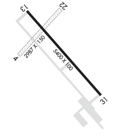
| Lat: N 4856.5 Long: W 09520.9 Elev: 1076 Var: -04 Longest Runway: 5400 | ||
| AWOS: 119.92 CTAF: 123.05 | ||
| ||||||
| ||||||
|
| Rwy | Rwy | |||||||
| 2987x150 | 2987' | 2987x150 | 2987' | |||||
| 5400x100 | 5400' | 5400x100 | 5400' | 110.10 - 314° | ||||
| Runway ID | Single Wheel | Double Wheel | Double Tandem Wheel | Dual Double Wheel |
| 04/22 | N/A | N/A | N/A | N/A |
| 13/31 | 30,000 | 40,000 | N/A | N/A |
| These numbers are Advisory and are not limits. The Airport Manager should have more accurate Weight Limits | ||||
 Airport Diagram might not be current. | |
| Facility Name: | WARROAD INTL MEML |
| City Name: | WARROAD |
| County: | ROSEAU |
| State abbrev: | MN |
| State Name: | MINNESOTA |
| Ownership: | PUBLICLY OWNED |
| Use: | OPEN TO THE PUBLIC |
| Owner's Name: | CITY OF WARROAD |
| Address: | CITY HALL, PO BOX 50 |
| WARROAD, MN 56763-0050 | |
| Owner's Phone: | 218-386-1454 |
| Manager's Name: | MATT RACHUY |
| Address: | PO BOX 50, 36955 COUNTY ROAD 13 |
| WARROAD, MN 56763-0050 | |
| Phone: | 218-386-1691 |
| FAA Region: | GREAT LAKES |
| FAA Field Office: | DMA |
| Date | Sunrise | Sunset |
|---|---|---|
| 09/24/21 Friday | 7:10 | 19:15 |
| 09/25/21 Saturday | 7:12 | 19:13 |
| 09/26/21 Sunday | 7:13 | 19:11 |
| 09/27/21 Monday | 7:15 | 19:09 |
| 09/28/21 Tuesday | 7:16 | 19:07 |
| 09/29/21 Wednesday | 7:18 | 19:05 |
| 09/30/21 Thursday | 7:19 | 19:03 |
| 10/01/21 Friday | 7:21 | 19:01 |
| 10/02/21 Saturday | 7:22 | 18:58 |
| 10/03/21 Sunday | 7:24 | 18:56 |
| 10/04/21 Monday | 7:25 | 18:54 |
| 10/05/21 Tuesday | 7:27 | 18:52 |
| 10/06/21 Wednesday | 7:28 | 18:50 |
| 10/07/21 Thursday | 7:30 | 18:48 |
| Airport Attendance Schedule | MON-FRI 0700-1700; FOR SER NGTS & WKENDS CALL AMGR. |
| Airport Status | OPERATIONAL (This Status can change at any time - please check NOTAMS) |
| Airport Lighting Schedule | ACTVT OR INCR INTST MALSR RWY 13 & 31; REIL RWY 13; HIRL RWY 13/31 - CTAF. PAPI RWY 13 & 31 OPR CONSLY; HIRL RWY 13/31 PRESET LOW INTST. PCL UNAVBL DRG DALGT HRS. |
| Airport Storage Available | Tie Downs, Hanger |
| Extra Services Available | NONE |
| Wind Indicator | YES - (lighted) |
| Control Tower | NO |
| CTAF Frequency | 123.050 |
| Unicom Frequency | 123.050 |
| Rotating Beacon Color | CLEAR-GREEN (Light Land Airport) |
| Segmented Circle | NO |
| Landing Fee | NO |
| Airport Inspected | STATE - performed by STATE AERONAUTICAL PERSONNEL |
| Inspection Date | 08/08/2019 |
| Type of Fuel Available | Grade 100LL, JET A (freeze point -40C); -10FUEL AVBL H24 SELF SER VIA CREDIT CARD. |
| Airframe Repair Service | NONE |
| Power Plant Repair Service | NONE |
| Latitude | N4856.5 |
| Longitude | W09520.9 (ESTIMATED) |
| Arpt Elevation | 1075ft (SURVEYED) |
| Magnetic Variation | 04E |
| 2 miles NW | of WARROAD |
| Traffic Pattern Altitude | |
| Sectional Chart | TWIN CITIES |
| Operations (Reported) | Yearly | Avg. Daily |
|---|---|---|
| General Aviation Transient | 3000 | 8 |
| General Aviation Local | 6000 | 16 |
| Air Taxi | 0 | 0 |
| Commerical | 0 | 0 |
| Commuter | 0 | 0 |
| Military | 0 | 0 |
| Aircraft based on Field | |
|---|---|
| General Aviation Singles | 11 |
| General Aviation Multi | 4 |
| Jet Aircraft | 1 |
| General Aviation Helicopters | 0 |
| Military Aircraft | 0 |
| Gliders | 0 |
| Ultralights | 0 |
| FSS on field | NO |
| FSS tie-in | PRINCETON |
| FSS Phone | 1-800-WX-BRIEF |
| Who issues Notams | RRT |
| Notam D service at airport | YES |
| ARTCC Name | MINNEAPOLIS |
| Airport Certification | |
| Aircraft Rescue & Firefighting Index | None |
| Airport of Entry | No |
| Custom Landing Rights | YES |
| Joint Civil/Military | No |
| Military Landing rights | YES |
| NATIONAL PLAN OF INTEGRATED AIRPORT SYSTEMS (NPIAS) |
| GRANT AGREEMENTS UNDER FAAP/ADAP/AIP |
| ASSURANCES PURSUANT TO TITLE VI, CIVIL RIGHTS ACT OF 1964 |
| DEER & BIRDS ON & INVOF ARPT. |
| CUST AVBL 1 HR PPR CALL 218-386-1676, CELL 218-689-3880, OTR 218-386-2796. |
| GCO AVBL ON FREQ 121.725 (MINNEAPOLIS CENTER AND FLIGHT SERVICES). |
| FOR CD IF UNA TO CTC ON FSS FREQ, CTC MINNEAPOLIS ARTCC AT 651-463-5588. |
| RWY 04/2 2 CLSD WINTER MONTHS. |
| RWY 31 CALM WIND RWY. |
Airport Communications & Frequencies:
| |||||||||
| Runway: 04 | Runway: 22 | ||
| Mag heading: | 38° | Mag heading: | 218° |
| Rwy Slope: | -.11% Down | Rwy Slope: | .11% Up |
| Approach: | Approach: | ||
| Pattern: | Left Traffic | Pattern: | Left Traffic |
| Markings: | Markings: | ||
| Marking Condition: | YELLOW CONES. | Marking Condition: | YELLOW CONES. |
| Arresting Dev: | Arresting Dev: | ||
| Lat & Long: | N4856.4 W09521.3 | Lat. & Long.: | N4856.8 W09520.8 |
| Elev: | 1073.1 ft. MSL | Elev: | 1069.9 ft. MSL |
| TCH: | TCH: | ||
| Visual Glide Path: | Visual Glide Path: | ||
| Displaced Threshold: | No | Displaced Threshold: | No |
| Touchdown Zone: | YES | Touchdown Zone: | YES |
| Touchdown Elev.: | 1073.8 feet | Touchdown Elev.: | 1073.8 feet |
| Visual Glide Slope: | Visual Glide Slope: | ||
| RVR Equipment: | RVR Equipment: | ||
| RVV Equipment: | NO | RVV Equipment: | NO |
| Approach Lights: | Approach Lights: | ||
| REIL: | NO | REIL: | NO |
| Centerline Lights: | NO | Centerline Lights: | NO |
| Touchdown lights: | NO | Touchdown lights: | NO |
| Runway Category: | Runway with a Visual Approach | Runway Category: | Runway with a Visual Approach |
| Declared Distances: | Declared Distances: |
| Runway: 13 | Runway: 31 | ||
| Mag heading: | 135° | Mag heading: | 315° |
| Rwy Slope: | .03% Up | Rwy Slope: | -.03% Down |
| Approach: | Approach: | ILS/DME | |
| Pattern: | Left Traffic | Pattern: | Left Traffic |
| Markings: | PRECISION INSTRUMENT | Markings: | PRECISION INSTRUMENT |
| Marking Condition: | GOOD | Marking Condition: | GOOD |
| Arresting Dev: | Arresting Dev: | ||
| Lat & Long: | N4856.8 W09521.3 | Lat. & Long.: | N4856.1 W09520.4 |
| Elev: | 1072.5 ft. MSL | Elev: | 1074.3 ft. MSL |
| TCH: | 29 ft. AGL | TCH: | 29 ft. AGL |
| Visual Glide Path: | 3.00 degrees | Visual Glide Path: | 3.00 degrees |
| Displaced Threshold: | No | Displaced Threshold: | No |
| Touchdown Zone: | YES | Touchdown Zone: | YES |
| Touchdown Elev.: | 1075.5 feet | Touchdown Elev.: | 1075.5 feet |
| Visual Glide Slope: | 4-Light PAPI on LEFT side of Runway | Visual Glide Slope: | 4-Light PAPI on LEFT side of Runway |
| RVR Equipment: | RVR Equipment: | ||
| RVV Equipment: | NO | RVV Equipment: | NO |
| Approach Lights: | MALSR - 1,400 foot medium intensity approach lighting system with runway alignment indicator lights | Approach Lights: | MALSR - 1,400 foot medium intensity approach lighting system with runway alignment indicator lights |
| REIL: | YES | REIL: | NO |
| Centerline Lights: | NO | Centerline Lights: | NO |
| Touchdown lights: | NO | Touchdown lights: | NO |
| Runway Category: | D | Runway Category: | Precision Instrument Runway |
| Declared Distances: | Declared Distances: | ||
| Obstructions: | Obstructions: | TREES | |
| Marked: | Marked: | NOT Marked/Lighted | |
| Clearance slope: | 34:1 | Clearance slope: | 46:1 |
| Obstruction height: | Obstruction height: | 78 feet AGL | |
| Dist. from runway: | Dist. from runway: | 3833 feet | |
| Centerline offset: | Centerline offset: | 248 feet right of centerline | |
| Comments: | Comments: |
Thanks for using FltPlan.com
all rights reserved © 1999-2021 by Flight Plan LLC
