
| ROANOKE RGNL/WOODRUM FIELD ROANOKE VA |
| |
| Lat: N 3719.5 Long: W 07958.5 Elev: 1175 Var: +08 Longest Runway: 6800 | ||
| Clr Del: 119.7 Dept. ATIS: 132.37 Arr. ATIS: 132.37 AWOS: 118.65 Ground: 121.9 Tower: 118.3 | ||
| ||||||||||||||||||||||||||||||||||||||||||||||||||||||||||||||||||||
| ||||||||||||||||||||||||||||||||||||||||||||||||||||||||||||||||||||
| ||||||||||||||||||||||||||||||||||||||||||||||||||||||||||||||||||||
| FBOs at nearby airports who want your business: | |||||||||||||||||
| |||||||||||||||||
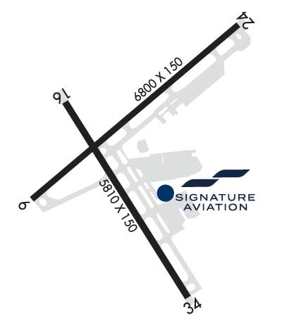
| Rwy | Rwy | |||||||
| 6800x150 | 6800' | 111.10 - 072° | 6800x150 | 6010' | ||||
| 5810x150 | 5810' | 5810x150 | 5810' | 109.70 - 335° | ||||
| Runway ID | Single Wheel | Double Wheel | Double Tandem Wheel | Dual Double Wheel |
| 06/24 | 150,000 | 200,000 | 310,000 | N/A |
| 16/34 | 150,000 | 200,000 | 310,000 | N/A |
| These numbers are Advisory and are not limits. The Airport Manager should have more accurate Weight Limits | ||||
 Airport Diagram might not be current. | |
| Facility Name: | ROANOKE-BLACKSBURG RGNL/WOODRUM FLD |
| City Name: | ROANOKE |
| County: | ROANOKE |
| State abbrev: | VA |
| State Name: | VIRGINIA |
| Ownership: | PUBLICLY OWNED |
| Use: | OPEN TO THE PUBLIC |
| Owner's Name: | ROANOKE BLACKSBURG RGNL/WOODRUM FIE |
| Address: | 5202 AVN DR. |
| ROANOKE, VA 24012-1148 | |
| Owner's Phone: | 540 362-1999 |
| Manager's Name: | DAVID S. JEAVONS (INTERIM) |
| Address: | 5202 AVN DR. |
| ROANOKE, VA 24012-1148 | |
| Phone: | 540-362-1999 |
| FAA Region: | EASTERN |
| FAA Field Office: | DCA |
| Date | Sunrise | Sunset |
|---|---|---|
| 09/24/21 Friday | 7:09 | 19:14 |
| 09/25/21 Saturday | 7:10 | 19:13 |
| 09/26/21 Sunday | 7:11 | 19:11 |
| 09/27/21 Monday | 7:12 | 19:10 |
| 09/28/21 Tuesday | 7:13 | 19:08 |
| 09/29/21 Wednesday | 7:13 | 19:06 |
| 09/30/21 Thursday | 7:14 | 19:05 |
| 10/01/21 Friday | 7:15 | 19:03 |
| 10/02/21 Saturday | 7:16 | 19:02 |
| 10/03/21 Sunday | 7:17 | 19:00 |
| 10/04/21 Monday | 7:18 | 18:59 |
| 10/05/21 Tuesday | 7:19 | 18:58 |
| 10/06/21 Wednesday | 7:19 | 18:56 |
| 10/07/21 Thursday | 7:20 | 18:55 |
| Airport Attendance Schedule | CONTINUOUS |
| Airport Status | OPERATIONAL (This Status can change at any time - please check NOTAMS) |
| Airport Lighting Schedule | SS-SR |
| Airport Storage Available | Tie Downs, Hanger |
| Extra Services Available | Air Freight, Air Ambulance, Cargo Handling, Charter, Flight Instruction, Aircraft Rental, Aircraft Sales, Annual Surveying |
| Wind Indicator | YES - (lighted) |
| Control Tower | YES |
| CTAF Frequency | |
| Unicom Frequency | 122.950 |
| Rotating Beacon Color | CLEAR-GREEN (Light Land Airport) |
| Segmented Circle | YES |
| Landing Fee | NO |
| Airport Inspected | FEDERAL - performed by STATE AERONAUTICAL PERSONNEL |
| Inspection Date | 06/08/2021 |
| Type of Fuel Available | Grade 100LL, JET A (freeze point -40C) |
| Airframe Repair Service | MAJOR |
| Power Plant Repair Service | MAJOR |
| Latitude | N3719.5 |
| Longitude | W07958.5 (ESTIMATED) |
| Arpt Elevation | 1175ft (SURVEYED) |
| Magnetic Variation | 08W |
| 3 miles NW | of ROANOKE |
| Traffic Pattern Altitude | 800 |
| Sectional Chart | CINCINNATI |
| Operations (Reported) | Yearly | Avg. Daily |
|---|---|---|
| General Aviation Transient | 13104 | 36 |
| General Aviation Local | 10738 | 29 |
| Air Taxi | 7781 | 21 |
| Commerical | 3612 | 10 |
| Commuter | 0 | 0 |
| Military | 976 | 3 |
| Aircraft based on Field | |
|---|---|
| General Aviation Singles | 73 |
| General Aviation Multi | 19 |
| Jet Aircraft | 9 |
| General Aviation Helicopters | 1 |
| Military Aircraft | 0 |
| Gliders | 0 |
| Ultralights | 0 |
| FSS on field | NO |
| FSS tie-in | LEESBURG |
| FSS Phone | 1-800-WX-BRIEF |
| Who issues Notams | ROA |
| Notam D service at airport | YES |
| ARTCC Name | WASHINGTON |
| Airport Certification | AIRPORT RECEIVING SCHEDULED AIR CARRIER SERVICE FROM CARRIERS CERTIFICATED BY THE CIVIL AERONAUTICS BOARD |
| Aircraft Rescue & Firefighting Index | AIRPORT HAS A CERTIFICATE UNDER CFR PART 139 |
| Airport of Entry | No |
| Custom Landing Rights | No |
| Joint Civil/Military | No |
| Military Landing rights | YES |
| NATIONAL PLAN OF INTEGRATED AIRPORT SYSTEMS (NPIAS) |
| GRANT AGREEMENTS UNDER FAAP/ADAP/AIP |
| COMPLIANCE WITH ACCESSIBILITY TO THE HANDICAPPED |
| ASSURANCES PURSUANT TO TITLE VI, CIVIL RIGHTS ACT OF 1964 |
| AGREEMENT UNDER DLAND OR DCLA HAS EXPIRED. |
| THIS AIRPORT HAS BEEN SURVEYED BY THE NATIONAL GEODETIC SURVEY. |
| DEP RWY 34 & ARR RWY 16 NA AT NIGHT OR DURING IFR COND DUE TO TRRN. |
| TSNT PILOTS CTC FBO UNICOM FOR ACFT PARKING AND ESCORT. |
| BIRDS INVOF ARPT. |
| TWY T CLSD TO ACFT WITH WINGSPAN GREATER THAN 118 FT. |
| COLD TEMPERATURE RESTRICTED AIRPORT. ALTITUDE CORRECTION REQUIRED AT OR BELOW -13C. |
| FOR OPR CONCERNS - ATCT 540-563-1307. |
| TKOF AND LNDG PER ASSESSMENT; RWY COND ASSESSMENT MATRIX NOT MNTD 2300-0600 DAILY. |
Airport Communications & Frequencies:
| |||||||||||||||||||||||||||||||||||||||||
| Runway: 06 | Runway: 24 | ||
| Mag heading: | 57° | Mag heading: | 237° |
| Rwy Slope: | -.02% Down | Rwy Slope: | .02% Up |
| Approach: | LDA/DME | Approach: | |
| Pattern: | Left Traffic | Pattern: | Left Traffic |
| Markings: | PRECISION INSTRUMENT | Markings: | NONPRECISION INSTRUMENT |
| Marking Condition: | GOOD | Marking Condition: | GOOD |
| Arresting Dev: | Arresting Dev: | ||
| Lat & Long: | N3719.3 W07959.0 | Lat. & Long.: | N3720.1 W07958.0 |
| Elev: | 1152.0 ft. MSL | Elev: | 1150.7 ft. MSL |
| TCH: | 58 ft. AGL | TCH: | 58 ft. AGL |
| Visual Glide Path: | 3.00 degrees | Visual Glide Path: | 3.00 degrees |
| Displaced Threshold: | No | Displaced Threshold: | 790 feet |
| Touchdown Zone: | YES | Touchdown Zone: | YES |
| Touchdown Elev.: | 1175.2 feet | Touchdown Elev.: | 1170.3 feet |
| Visual Glide Slope: | 4-BOX VASI ON LEFT SIDE OF RUNWAY | Visual Glide Slope: | 4-Light PAPI on LEFT side of Runway; PAPI UNUSBL BYD 5 DEGS R OF CNTRLN DUE TO TRRN. |
| RVR Equipment: | RVR Equipment: | ||
| RVV Equipment: | NO | RVV Equipment: | NO |
| Approach Lights: | MALSR - 1,400 foot medium intensity approach lighting system with runway alignment indicator lights | Approach Lights: | |
| REIL: | YES | REIL: | YES |
| Centerline Lights: | NO | Centerline Lights: | NO |
| Touchdown lights: | NO | Touchdown lights: | NO |
| Runway Category: | D | Runway Category: | Runway with a Non-precision Approach having visibility minimums greater than 3/4 mile |
| Declared Distances: | TORA:6800' TODA:6800' ASDA:6800' LDA:6800' | Declared Distances: | TORA:6800' TODA:6800' ASDA:6800' LDA:6010' |
| Runway: 16 | Runway: 34 | ||
| Mag heading: | 156° | Mag heading: | 336° |
| Rwy Slope: | -.39% Down | Rwy Slope: | .39% Up |
| Approach: | Approach: | ILS | |
| Pattern: | Left Traffic | Pattern: | Left Traffic |
| Markings: | NONPRECISION INSTRUMENT | Markings: | PRECISION INSTRUMENT |
| Marking Condition: | GOOD | Marking Condition: | GOOD |
| Arresting Dev: | Arresting Dev: | EMAS; ENGINEERED MATERIALS ARRESTING SYSTEM (EMAS) 299 FT IN LENGTH BY 169 FT IN WIDTH LCTD AT DER 34. | |
| Lat & Long: | N3719.7 W07958.9 | Lat. & Long.: | N3718.9 W07958.2 |
| Elev: | 1165.6 ft. MSL | Elev: | 1142.9 ft. MSL |
| TCH: | TCH: | 56 ft. AGL | |
| Visual Glide Path: | Visual Glide Path: | 3.00 degrees | |
| Displaced Threshold: | No | Displaced Threshold: | No |
| Touchdown Zone: | YES | Touchdown Zone: | YES |
| Touchdown Elev.: | 1173.3 feet | Touchdown Elev.: | 1160.1 feet |
| Visual Glide Slope: | Visual Glide Slope: | 4-Light PAPI on LEFT side of Runway | |
| RVR Equipment: | RVR Equipment: | ||
| RVV Equipment: | NO | RVV Equipment: | NO |
| Approach Lights: | Approach Lights: | MALSR - 1,400 foot medium intensity approach lighting system with runway alignment indicator lights | |
| REIL: | NO | REIL: | NO |
| Centerline Lights: | NO | Centerline Lights: | NO |
| Touchdown lights: | NO | Touchdown lights: | NO |
| Runway Category: | Runway with a Visual Approach | Runway Category: | Precision Instrument Runway |
| Declared Distances: | TORA:5810' TODA:5810' ASDA:5810' LDA:5810' | Declared Distances: | TORA:5810' TODA:5810' ASDA:5810' LDA:5810' |
| Obstructions: | Obstructions: | TOWER | |
| Marked: | Marked: | LIGHTED | |
| Clearance slope: | 50:1 | Clearance slope: | 30:1 |
| Obstruction height: | Obstruction height: | 837 feet AGL | |
| Dist. from runway: | Dist. from runway: | 26070 feet | |
| Centerline offset: | Centerline offset: | ||
| Comments: | Comments: |
Thanks for using FltPlan.com
all rights reserved © 1999-2021 by Flight Plan LLC