
| WORTHINGTON MUNI WORTHINGTON MN |
| |
| Lat: N 4339.3 Long: W 09534.8 Elev: 1574 Var: -02 Longest Runway: 5500 | ||
| AWOS: 110.6 CTAF: 122.8 | ||
| ||||||||||||||||||||||||||||||||||||||||||||||||||||||||||||||||||||
| ||||||||||||||||||||||||||||||||||||||||||||||||||||||||||||||||||||
| ||||||||||||||||||||||||||||||||||||||||||||||||||||||||||||||||||||
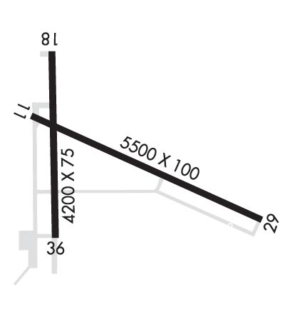
| Rwy | Rwy | |||||||
| 5500x100 | 5500' | 5500x100 | 5500' | 111.70 - 292° | ||||
| 4200x75 | 4200' | 4200x75 | 4200' | |||||
| Runway ID | Single Wheel | Double Wheel | Double Tandem Wheel | Dual Double Wheel |
| 11/29 | 44,000 | 60,000 | N/A | N/A |
| 18/36 | 44,000 | 60,000 | N/A | N/A |
| These numbers are Advisory and are not limits. The Airport Manager should have more accurate Weight Limits | ||||
 Airport Diagram might not be current. | |
| Facility Name: | WORTHINGTON MUNI |
| City Name: | WORTHINGTON |
| County: | NOBLES |
| State abbrev: | MN |
| State Name: | MINNESOTA |
| Ownership: | PUBLICLY OWNED |
| Use: | OPEN TO THE PUBLIC |
| Owner's Name: | CITY OF WORTHINGTON |
| Address: | 303 NINTH ST., BOX 279 |
| WORTHINGTON, MN 56187 | |
| Owner's Phone: | 507-372-8600 |
| Manager's Name: | TODD WIETZEMA; CAMERON JOHNSON - 507-376-9293. |
| Address: | 303 NINTH ST., BOX 279 |
| WORTHINGTON, MN 56817-0279 | |
| Phone: | 507-372-8650 |
| FAA Region: | GREAT LAKES |
| FAA Field Office: | DMA |
| Date | Sunrise | Sunset |
|---|---|---|
| 09/24/21 Friday | 7:12 | 19:16 |
| 09/25/21 Saturday | 7:13 | 19:15 |
| 09/26/21 Sunday | 7:14 | 19:13 |
| 09/27/21 Monday | 7:15 | 19:11 |
| 09/28/21 Tuesday | 7:16 | 19:09 |
| 09/29/21 Wednesday | 7:17 | 19:07 |
| 09/30/21 Thursday | 7:18 | 19:05 |
| 10/01/21 Friday | 7:20 | 19:04 |
| 10/02/21 Saturday | 7:21 | 19:02 |
| 10/03/21 Sunday | 7:22 | 19:00 |
| 10/04/21 Monday | 7:23 | 18:58 |
| 10/05/21 Tuesday | 7:24 | 18:57 |
| 10/06/21 Wednesday | 7:25 | 18:55 |
| 10/07/21 Thursday | 7:27 | 18:53 |
| Airport Attendance Schedule | MON-FRI 0800-1700; FOR SVC CALL 507-376-9293; AFT HRS CALL 507-360-3731. |
| Airport Status | OPERATIONAL (This Status can change at any time - please check NOTAMS) |
| Airport Lighting Schedule | ACTVT MALSR RWY 29; REIL RWY 11, 18 & 36; PAPI RWY 18 & 36; MIRL RWY 18/36 - CTAF. HIRL RWY 11/29 PRESET ON LOW INTST; TO INCR INTST - CTAF. PAPI RWY 11 & 29 OPR CONSLY. |
| Airport Storage Available | Tie Downs, Hanger |
| Extra Services Available | Crop Dusting, Flight Instruction, Aircraft Rental, Aircraft Sales |
| Wind Indicator | YES - (lighted) |
| Control Tower | NO |
| CTAF Frequency | 122.800 |
| Unicom Frequency | 122.800 |
| Rotating Beacon Color | CLEAR-GREEN (Light Land Airport) |
| Segmented Circle | YES |
| Landing Fee | NO |
| Airport Inspected | FEDERAL - performed by STATE AERONAUTICAL PERSONNEL |
| Inspection Date | 08/20/2019 |
| Type of Fuel Available | Grade 100LL, JET A (freeze point -40C); -A SELF SVC FUEL AVBL WITH CREDIT CARD. JET A TRUCK AVBL WHEN ATNDD.; -10SELF SVC FUEL WITH CREDIT CARD. |
| Airframe Repair Service | MAJOR |
| Power Plant Repair Service | MINOR |
| Latitude | N4339.3 |
| Longitude | W09534.8 (ESTIMATED) |
| Arpt Elevation | 1574ft (SURVEYED) |
| Magnetic Variation | 02E |
| 2 miles N | of WORTHINGTON |
| Traffic Pattern Altitude | |
| Sectional Chart | OMAHA |
| Operations (Reported) | Yearly | Avg. Daily |
|---|---|---|
| General Aviation Transient | 2500 | 7 |
| General Aviation Local | 7040 | 19 |
| Air Taxi | 100 | 0 |
| Commerical | 0 | 0 |
| Commuter | 0 | 0 |
| Military | 500 | 1 |
| Aircraft based on Field | |
|---|---|
| General Aviation Singles | 18 |
| General Aviation Multi | 3 |
| Jet Aircraft | 1 |
| General Aviation Helicopters | 0 |
| Military Aircraft | 0 |
| Gliders | 0 |
| Ultralights | 0 |
| FSS on field | NO |
| FSS tie-in | PRINCETON |
| FSS Phone | 1-800-WX-BRIEF |
| Who issues Notams | OTG |
| Notam D service at airport | YES |
| ARTCC Name | MINNEAPOLIS |
| Airport Certification | |
| Aircraft Rescue & Firefighting Index | None |
| Airport of Entry | No |
| Custom Landing Rights | No |
| Joint Civil/Military | No |
| Military Landing rights | YES |
| NATIONAL PLAN OF INTEGRATED AIRPORT SYSTEMS (NPIAS) |
| GRANT AGREEMENTS UNDER FAAP/ADAP/AIP |
| ASSURANCES PURSUANT TO TITLE VI, CIVIL RIGHTS ACT OF 1964 |
Airport Communications & Frequencies:
| |||||||||
| Runway: 11 | Runway: 29 | ||
| Mag heading: | 113° | Mag heading: | 293° |
| Rwy Slope: | -.13% Down | Rwy Slope: | .13% Up |
| Approach: | Approach: | ILS | |
| Pattern: | Left Traffic | Pattern: | Left Traffic |
| Markings: | NONPRECISION INSTRUMENT | Markings: | PRECISION INSTRUMENT |
| Marking Condition: | GOOD | Marking Condition: | GOOD |
| Arresting Dev: | Arresting Dev: | ||
| Lat & Long: | N4339.5 W09535.1 | Lat. & Long.: | N4339.1 W09534.0 |
| Elev: | 1573.5 ft. MSL | Elev: | 1566.4 ft. MSL |
| TCH: | 42 ft. AGL | TCH: | 43 ft. AGL |
| Visual Glide Path: | 3.00 degrees | Visual Glide Path: | 3.00 degrees |
| Displaced Threshold: | No | Displaced Threshold: | No |
| Touchdown Zone: | YES | Touchdown Zone: | YES |
| Touchdown Elev.: | 1574.0 feet | Touchdown Elev.: | 1570.4 feet |
| Visual Glide Slope: | 4-Light PAPI on LEFT side of Runway | Visual Glide Slope: | 4-Light PAPI on LEFT side of Runway |
| RVR Equipment: | RVR Equipment: | ||
| RVV Equipment: | NO | RVV Equipment: | NO |
| Approach Lights: | Approach Lights: | MALSR - 1,400 foot medium intensity approach lighting system with runway alignment indicator lights | |
| REIL: | YES | REIL: | NO |
| Centerline Lights: | NO | Centerline Lights: | NO |
| Touchdown lights: | NO | Touchdown lights: | NO |
| Runway Category: | Runway with a Non-precision Approach having visibility minimums greater than 3/4 mile | Runway Category: | Precision Instrument Runway |
| Declared Distances: | Declared Distances: |
| Runway: 18 | Runway: 36 | ||
| Mag heading: | 178° | Mag heading: | 358° |
| Rwy Slope: | .06% Up | Rwy Slope: | -.06% Down |
| Approach: | Approach: | ||
| Pattern: | Left Traffic | Pattern: | Left Traffic |
| Markings: | NONPRECISION INSTRUMENT | Markings: | NONPRECISION INSTRUMENT |
| Marking Condition: | GOOD | Marking Condition: | GOOD |
| Arresting Dev: | Arresting Dev: | ||
| Lat & Long: | N4339.7 W09535.0 | Lat. & Long.: | N4339.0 W09535.0 |
| Elev: | 1571.4 ft. MSL | Elev: | 1573.9 ft. MSL |
| TCH: | 30 ft. AGL | TCH: | 30 ft. AGL |
| Visual Glide Path: | 3.00 degrees | Visual Glide Path: | 3.00 degrees |
| Displaced Threshold: | No | Displaced Threshold: | No |
| Touchdown Zone: | YES | Touchdown Zone: | YES |
| Touchdown Elev.: | 1573.6 feet | Touchdown Elev.: | 1574.0 feet |
| Visual Glide Slope: | 4-Light PAPI on LEFT side of Runway | Visual Glide Slope: | 4-Light PAPI on LEFT side of Runway |
| RVR Equipment: | RVR Equipment: | ||
| RVV Equipment: | NO | RVV Equipment: | NO |
| Approach Lights: | Approach Lights: | ||
| REIL: | YES | REIL: | YES |
| Centerline Lights: | NO | Centerline Lights: | NO |
| Touchdown lights: | NO | Touchdown lights: | NO |
| Runway Category: | Runway with a Non-precision Approach having visibility minimums greater than 3/4 mile | Runway Category: | Runway with a Non-precision Approach having visibility minimums greater than 3/4 mile |
| Declared Distances: | Declared Distances: |
Thanks for using FltPlan.com
all rights reserved © 1999-2021 by Flight Plan LLC


