
| MONROE COUNTY MONROEVILLE AL |
| |
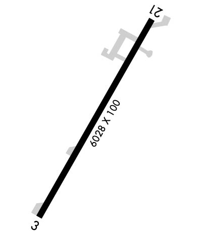
| Lat: N 3127.5 Long: W 08721.1 Elev: 419 Var: -02 Longest Runway: 6028 | ||
| CTAF: 123.0 | ||
| ||||||||||||||||||||||||||||||||||||||||||||
| ||||||||||||||||||||||||||||||||||||||||||||
| Rwy | Rwy | |||||||
| 6028x100 | 6028' | 6028x100 | 6028' | |||||
| Runway ID | Single Wheel | Double Wheel | Double Tandem Wheel | Dual Double Wheel |
| 03/21 | 70,000 | N/A | N/A | N/A |
| These numbers are Advisory and are not limits. The Airport Manager should have more accurate Weight Limits | ||||
 Airport Diagram might not be current. | |
| Facility Name: | MONROE COUNTY AEROPLEX |
| City Name: | MONROEVILLE |
| County: | MONROE |
| State abbrev: | AL |
| State Name: | ALABAMA |
| Ownership: | PUBLICLY OWNED |
| Use: | OPEN TO THE PUBLIC |
| Owner's Name: | MONROE COUNTY |
| Address: | PO BOX 8 |
| MONROEVILLE, AL 36461 | |
| Owner's Phone: | 251-575-2081 |
| Manager's Name: | JASON WELCH; ADDL CTC FBO MATT OKULY, MONROEVILLE AVIATION AT 251-575-4235. |
| Address: | PO BOX 191 |
| MONROEVILLE, AL 36461 | |
| Phone: | 251-593-6828 |
| FAA Region: | SOUTHERN |
| FAA Field Office: | JAN |
| Date | Sunrise | Sunset |
|---|---|---|
| 05/05/26 Tuesday | 6:01 | 19:32 |
| 05/06/26 Wednesday | 6:00 | 19:32 |
| 05/07/26 Thursday | 5:59 | 19:33 |
| 05/08/26 Friday | 5:58 | 19:34 |
| 05/09/26 Saturday | 5:58 | 19:34 |
| 05/10/26 Sunday | 5:57 | 19:35 |
| 05/11/26 Monday | 5:56 | 19:36 |
| 05/12/26 Tuesday | 5:55 | 19:37 |
| 05/13/26 Wednesday | 5:55 | 19:37 |
| 05/14/26 Thursday | 5:54 | 19:38 |
| 05/15/26 Friday | 5:53 | 19:39 |
| 05/16/26 Saturday | 5:53 | 19:39 |
| 05/17/26 Sunday | 5:52 | 19:40 |
| 05/18/26 Monday | 5:51 | 19:41 |
| Airport Attendance Schedule | MON-FRI 0800-2000, SAT-SUN 0800-1700 |
| Airport Status | OPERATIONAL (This Status can change at any time - please check NOTAMS) |
| Airport Lighting Schedule | ACTVT REIL RWY 03 & 21; PAPI RWY 03 & 21 - CTAF. |
| Airport Storage Available | Tie Downs |
| Extra Services Available | NONE |
| Wind Indicator | YES - (lighted) |
| Control Tower | NO |
| CTAF Frequency | 123.000 |
| Unicom Frequency | 123.000 |
| Rotating Beacon Color | WG |
| Segmented Circle | NO |
| Landing Fee | NO |
| Airport Inspected | STATE - performed by STATE AERONAUTICAL PERSONNEL |
| Inspection Date | 09/10/2025 |
| Type of Fuel Available | Grade 100LL, JET A |
| Airframe Repair Service | NONE |
| Power Plant Repair Service | NONE |
| Latitude | N3127.5 |
| Longitude | W08721.1 (ESTIMATED) |
| Arpt Elevation | 419ft (SURVEYED) |
| Magnetic Variation | 02E |
| 3 miles S | of MONROEVILLE |
| Traffic Pattern Altitude | |
| Sectional Chart | NEW ORLEANS |
| Operations (Reported) | Yearly | Avg. Daily |
|---|---|---|
| General Aviation Transient | 0 | 0 |
| General Aviation Local | 0 | 0 |
| Air Taxi | 0 | 0 |
| Commerical | 0 | 0 |
| Commuter | 0 | 0 |
| Military | 0 | 0 |
| Aircraft based on Field | |
|---|---|
| General Aviation Singles | 0 |
| General Aviation Multi | 0 |
| Jet Aircraft | 0 |
| General Aviation Helicopters | 0 |
| Military Aircraft | 0 |
| Gliders | 0 |
| Ultralights | 0 |
| FSS on field | NO |
| FSS tie-in | ANNISTON |
| FSS Phone | 1-800-WX-BRIEF |
| Who issues Notams | ANB |
| Notam D service at airport | YES |
| ARTCC Name | ATLANTA |
| Airport Certification | |
| Aircraft Rescue & Firefighting Index | None |
| Airport of Entry | No |
| Custom Landing Rights | No |
| Joint Civil/Military | No |
| Military Landing rights | No |
| NATIONAL PLAN OF INTEGRATED AIRPORT SYSTEMS (NPIAS) |
| THIS AIRPORT HAS BEEN SURVEYED BY THE NATIONAL GEODETIC SURVEY. |
| RWY 03/2 1 CRACKING ON RWY |
Airport Communications & Frequencies:
| |||||||||
| Runway: 03 | Runway: 21 | ||
| Mag heading: | 28° | Mag heading: | 208° |
| Rwy Slope: | .10% Up | Rwy Slope: | -.10% Down |
| Approach: | Approach: | ||
| Pattern: | Left Traffic | Pattern: | Left Traffic |
| Markings: | NONPRECISION INSTRUMENT | Markings: | NONPRECISION INSTRUMENT |
| Marking Condition: | FAIR | Marking Condition: | FAIR |
| Arresting Dev: | Arresting Dev: | ||
| Lat & Long: | N3127.1 W08721.3 | Lat. & Long.: | N3127.9 W08720.8 |
| Elev: | 412.2 ft. MSL | Elev: | 418.5 ft. MSL |
| TCH: | 62 ft. AGL | TCH: | 40 ft. AGL |
| Visual Glide Path: | 3.00 degrees | Visual Glide Path: | 3.00 degrees |
| Displaced Threshold: | No | Displaced Threshold: | No |
| Touchdown Zone: | YES | Touchdown Zone: | YES |
| Touchdown Elev.: | 416.6 feet | Touchdown Elev.: | 419.1 feet |
| Visual Glide Slope: | 4-Light PAPI on LEFT side of Runway | Visual Glide Slope: | 4-Light PAPI on LEFT side of Runway |
| RVR Equipment: | RVR Equipment: | ||
| RVV Equipment: | NO | RVV Equipment: | NO |
| Approach Lights: | Approach Lights: | ||
| REIL: | YES | REIL: | YES |
| Centerline Lights: | NO | Centerline Lights: | NO |
| Touchdown lights: | NO | Touchdown lights: | NO |
| Runway Category: | Runway with a Non-precision Approach having visibility minimums greater than 3/4 mile | Runway Category: | Runway with a Non-precision Approach having visibility minimums greater than 3/4 mile |
| Declared Distances: | Declared Distances: | ||
| Obstructions: | TREE | Obstructions: | TREE |
| Marked: | NOT Marked/Lighted | Marked: | NOT Marked/Lighted |
| Clearance slope: | 9:1 | Clearance slope: | 8:1 |
| Obstruction height: | 73 feet AGL | Obstruction height: | 79 feet AGL |
| Dist. from runway: | 858 feet | Dist. from runway: | 848 feet |
| Centerline offset: | 337 right of centerline | Centerline offset: | 342 feet right of centerline |
| Comments: | Comments: |
Thanks for using FltPlan.com
all rights reserved © 1999-2026 by Flight Plan LLC
