| INDIANAPOLIS REGIONAL INDIANAPOLIS IN |
| |
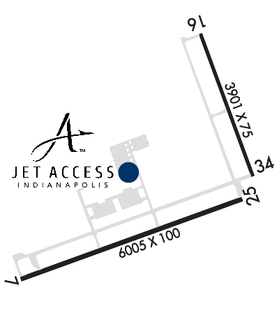
| Lat: N 3950.6 Long: W 08553.9 Elev: 862 Var: +02 Longest Runway: 6005 | ||
| Clr Del: 119.25 AWOS: 124.17 CTAF: 122.97 | ||
| |||||||||||||||||||||||||||||||
| |||||||||||||||||||||||||||||||
| |||||||||||||||||||||||||||||||
| FBOs at nearby airports who want your business: | |||||||||||||||||
| |||||||||||||||||
| |||||||||||||||||
| Rwy | Rwy | |||||||
| 6005x100 | 6005' | 6005x100 | 6005' | 108.70 - 252° | ||||
| 3901x75 | 3901' | 3901x75 | 3901' | |||||
| Runway ID | Single Wheel | Double Wheel | Double Tandem Wheel | Dual Double Wheel |
| 07/25 | 30,000 | 75,000 | N/A | N/A |
| 16/34 | 12,500 | N/A | N/A | N/A |
| These numbers are Advisory and are not limits. The Airport Manager should have more accurate Weight Limits | ||||
 Airport Diagram might not be current. | |
| Facility Name: | INDIANAPOLIS RGNL |
| City Name: | INDIANAPOLIS |
| County: | HANCOCK |
| State abbrev: | IN |
| State Name: | INDIANA |
| Ownership: | PUBLICLY OWNED |
| Use: | OPEN TO THE PUBLIC |
| Owner's Name: | INDIANAPOLIS ARPT AUTHORITY |
| Address: | 7800 COL. H. WEIR COOK MEMORIAL DR. |
| INDIANAPOLIS, IN 46241 | |
| Owner's Phone: | (317) 487-5022 |
| Manager's Name: | KEITH BERLEN |
| Address: | 7800 COL. H. WEIR COOK MEMORIAL DR. |
| INDIANAPOLIS, IN 46241 | |
| Phone: | (317) 487-5022 |
| FAA Region: | GREAT LAKES |
| FAA Field Office: | CHI |
| Date | Sunrise | Sunset |
|---|---|---|
| 09/24/21 Friday | 7:33 | 19:38 |
| 09/25/21 Saturday | 7:34 | 19:36 |
| 09/26/21 Sunday | 7:35 | 19:34 |
| 09/27/21 Monday | 7:36 | 19:33 |
| 09/28/21 Tuesday | 7:37 | 19:31 |
| 09/29/21 Wednesday | 7:38 | 19:30 |
| 09/30/21 Thursday | 7:39 | 19:28 |
| 10/01/21 Friday | 7:40 | 19:26 |
| 10/02/21 Saturday | 7:41 | 19:25 |
| 10/03/21 Sunday | 7:42 | 19:23 |
| 10/04/21 Monday | 7:43 | 19:22 |
| 10/05/21 Tuesday | 7:44 | 19:20 |
| 10/06/21 Wednesday | 7:45 | 19:18 |
| 10/07/21 Thursday | 7:46 | 19:17 |
| Airport Attendance Schedule | 7 Days A Week 0700-2100; FOR ATTENDANT ON CHRISTMAS & THANKSGIVING DAY OR FOR OUTSIDE NORMAL OPERATING HRS CALL 317-335-3371. |
| Airport Status | OPERATIONAL (This Status can change at any time - please check NOTAMS) |
| Airport Lighting Schedule | DUSK-DAWN. ACTVT HIRL RY 07/25 & MALSR RY 25 - CTAF. |
| Airport Storage Available | Tie Downs, Hanger |
| Extra Services Available | Air Freight, Cargo Handling, Charter, Flight Instruction, Aircraft Rental, Aircraft Sales |
| Wind Indicator | YES - (lighted) |
| Control Tower | NO |
| CTAF Frequency | 122.975 |
| Unicom Frequency | 122.975 |
| Rotating Beacon Color | CLEAR-GREEN (Light Land Airport) |
| Segmented Circle | YES; LOCATED AROUND MID-FIELD WIND SOCK |
| Landing Fee |
| Airport Inspected | FEDERAL - performed by STATE AERONAUTICAL PERSONNEL |
| Inspection Date | 08/13/2018 |
| Type of Fuel Available | Grade 100LL, JET A (freeze point -40C), JET A |
| Airframe Repair Service | MAJOR |
| Power Plant Repair Service | MAJOR |
| Latitude | N3950.6 |
| Longitude | W08553.9 (ESTIMATED) |
| Arpt Elevation | 862ft (SURVEYED) |
| Magnetic Variation | 02W |
| 12 miles E | of INDIANAPOLIS |
| Traffic Pattern Altitude | |
| Sectional Chart | ST LOUIS |
| Operations (Reported) | Yearly | Avg. Daily |
|---|---|---|
| General Aviation Transient | 15505 | 42 |
| General Aviation Local | 10543 | 29 |
| Air Taxi | 4961 | 14 |
| Commerical | 0 | 0 |
| Commuter | 0 | 0 |
| Military | 0 | 0 |
| Aircraft based on Field | |
|---|---|
| General Aviation Singles | 78 |
| General Aviation Multi | 6 |
| Jet Aircraft | 9 |
| General Aviation Helicopters | 0 |
| Military Aircraft | 0 |
| Gliders | 0 |
| Ultralights | 1 |
| FSS on field | NO |
| FSS tie-in | TERRE HAUTE |
| FSS Phone | 1-800-WX-BRIEF |
| Who issues Notams | HUF |
| Notam D service at airport | YES |
| ARTCC Name | INDIANAPOLIS |
| Airport Certification | |
| Aircraft Rescue & Firefighting Index | None |
| Airport of Entry | No |
| Custom Landing Rights | No |
| Joint Civil/Military | No |
| Military Landing rights | YES |
| NATIONAL PLAN OF INTEGRATED AIRPORT SYSTEMS (NPIAS) |
| GRANT AGREEMENTS UNDER FAAP/ADAP/AIP |
| ASSURANCES PURSUANT TO TITLE VI, CIVIL RIGHTS ACT OF 1964 |
| RWY 16/34 & TWY B NOT AVBL TO ACR ACFT WITH MORE THAN 30 PAX SEATS. |
| FOR FUEL AND ACFT SVCS CTC FBO ON 131.5 |
| FOR CD CTC INDIANAPOLIS APCH AT 317-227-5743. |
Airport Communications & Frequencies:
| ||||||||||||||||
| Runway: 07 | Runway: 25 | ||
| Mag heading: | 72° | Mag heading: | 252° |
| Rwy Slope: | -.07% Down | Rwy Slope: | .07% Up |
| Approach: | Approach: | ILS | |
| Pattern: | Left Traffic | Pattern: | Left Traffic |
| Markings: | NONPRECISION INSTRUMENT | Markings: | PRECISION INSTRUMENT |
| Marking Condition: | GOOD | Marking Condition: | GOOD |
| Arresting Dev: | Arresting Dev: | ||
| Lat & Long: | N3950.2 W08554.7 | Lat. & Long.: | N3950.5 W08553.5 |
| Elev: | 862.1 ft. MSL | Elev: | 858.0 ft. MSL |
| TCH: | 40 ft. AGL | TCH: | 55 ft. AGL |
| Visual Glide Path: | 3.00 degrees | Visual Glide Path: | 3.00 degrees |
| Displaced Threshold: | No | Displaced Threshold: | No |
| Touchdown Zone: | YES | Touchdown Zone: | YES |
| Touchdown Elev.: | 862.2 feet | Touchdown Elev.: | 860.4 feet |
| Visual Glide Slope: | 4-Light PAPI on RIGHT side of Runway | Visual Glide Slope: | 4-Light PAPI on LEFT side of Runway |
| RVR Equipment: | RVR Equipment: | ||
| RVV Equipment: | NO | RVV Equipment: | NO |
| Approach Lights: | Approach Lights: | MALSR - 1,400 foot medium intensity approach lighting system with runway alignment indicator lights | |
| REIL: | YES | REIL: | NO |
| Centerline Lights: | NO | Centerline Lights: | NO |
| Touchdown lights: | NO | Touchdown lights: | NO |
| Runway Category: | Runway with a Visual Approach | Runway Category: | Precision Instrument Runway |
| Declared Distances: | Declared Distances: | ||
| Comments: | CROPS 250 FT SOUTH OF RWY END | Comments: |
| Runway: 16 | Runway: 34 | ||
| Mag heading: | 162° | Mag heading: | 342° |
| Rwy Slope: | -.02% Down | Rwy Slope: | .02% Up |
| Approach: | Approach: | ||
| Pattern: | Left Traffic | Pattern: | Left Traffic |
| Markings: | NONPRECISION INSTRUMENT | Markings: | NONPRECISION INSTRUMENT |
| Marking Condition: | GOOD | Marking Condition: | GOOD |
| Arresting Dev: | Arresting Dev: | ||
| Lat & Long: | N3951.2 W08553.7 | Lat. & Long.: | N3950.6 W08553.4 |
| Elev: | 857.7 ft. MSL | Elev: | 856.9 ft. MSL |
| TCH: | 46 ft. AGL | TCH: | 49 ft. AGL |
| Visual Glide Path: | 3.00 degrees | Visual Glide Path: | 3.00 degrees |
| Displaced Threshold: | No | Displaced Threshold: | No |
| Touchdown Zone: | YES | Touchdown Zone: | YES |
| Touchdown Elev.: | 857.7 feet | Touchdown Elev.: | 857.7 feet |
| Visual Glide Slope: | 2-Light PAPI on LEFT side of Runway | Visual Glide Slope: | 2-Light PAPI on LEFT side of Runway |
| RVR Equipment: | RVR Equipment: | ||
| RVV Equipment: | NO | RVV Equipment: | NO |
| Approach Lights: | Approach Lights: | ||
| REIL: | NO | REIL: | YES |
| Centerline Lights: | NO | Centerline Lights: | NO |
| Touchdown lights: | NO | Touchdown lights: | NO |
| Runway Category: | Runway with a Non-precision Approach | Runway Category: | Runway with a Non-precision Approach |
| Declared Distances: | Declared Distances: | ||
| Comments: | CROPS 155 FT FM & 175 FT W OF RWY END | Comments: |
Thanks for using FltPlan.com
all rights reserved © 1999-2021 by Flight Plan LLC