
| SANTEE COOPER RGNL MANNING SC |
| |
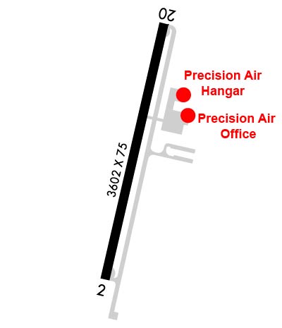
| Lat: N 3335.2 Long: W 08012.5 Elev: 103 Var: +06 Longest Runway: 3602 | ||
| AWOS: 120.17 CTAF: 122.8 | ||
| |||||||||||||||||||||||||||||||||||||||||||||||||||||||||||||
| |||||||||||||||||||||||||||||||||||||||||||||||||||||||||||||
| |||||||||||||||||||||||||||||||||||||||||||||||||||||||||||||
| Rwy | Rwy | |||||||
| 3602x75 | 3602' | 3602x75 | 3602' | |||||
| Runway ID | Single Wheel | Double Wheel | Double Tandem Wheel | Dual Double Wheel |
| 02/20 | 30,000 | N/A | N/A | N/A |
| These numbers are Advisory and are not limits. The Airport Manager should have more accurate Weight Limits | ||||
 Airport Diagram might not be current. | |
| Facility Name: | SANTEE COOPER RGNL |
| City Name: | MANNING |
| County: | CLARENDON |
| State abbrev: | SC |
| State Name: | SOUTH CAROLINA |
| Ownership: | PUBLICLY OWNED |
| Use: | OPEN TO THE PUBLIC |
| Owner's Name: | CLARENDON COUNTY |
| Address: | PO BOX 486 |
| MANNING, SC 29102 | |
| Owner's Phone: | 803-435-8424 |
| Manager's Name: | MS. VICKIE WILLIAMS |
| Address: | 8606 HIGHWAY 260 |
| MANNING, SC 29102 | |
| Phone: | 803-433-4004 |
| FAA Region: | SOUTHERN |
| FAA Field Office: | ATL |
| Date | Sunrise | Sunset |
|---|---|---|
| 05/04/26 Monday | 6:30 | 20:06 |
| 05/05/26 Tuesday | 6:29 | 20:07 |
| 05/06/26 Wednesday | 6:28 | 20:08 |
| 05/07/26 Thursday | 6:27 | 20:08 |
| 05/08/26 Friday | 6:26 | 20:09 |
| 05/09/26 Saturday | 6:25 | 20:10 |
| 05/10/26 Sunday | 6:24 | 20:11 |
| 05/11/26 Monday | 6:23 | 20:11 |
| 05/12/26 Tuesday | 6:23 | 20:12 |
| 05/13/26 Wednesday | 6:22 | 20:13 |
| 05/14/26 Thursday | 6:21 | 20:14 |
| 05/15/26 Friday | 6:20 | 20:14 |
| 05/16/26 Saturday | 6:20 | 20:15 |
| 05/17/26 Sunday | 6:19 | 20:16 |
| Airport Attendance Schedule | MON-FRI 0800-1700 |
| Airport Status | OPERATIONAL (This Status can change at any time - please check NOTAMS) |
| Airport Lighting Schedule | MIRL PRESET LOW INTST DUSK-2300; TO INCR INTST - CTAF. TO ACTVT AFT 2300 - CTAF. |
| Airport Storage Available | Tie Downs |
| Extra Services Available | Avionics, Glider |
| Wind Indicator | YES - (lighted) |
| Control Tower | NO |
| CTAF Frequency | 122.800 |
| Unicom Frequency | 122.800 |
| Rotating Beacon Color | WG |
| Segmented Circle | YES |
| Landing Fee | NO |
| Airport Inspected | STATE - performed by STATE AERONAUTICAL PERSONNEL |
| Inspection Date | 09/12/2025 |
| Type of Fuel Available | Grade 100LL, JET A (freeze point -40C); -10SELF SVC 100LL AVBL 24 HRS WITH CREDIT CARD.; -A SELF SVC JET-A AVBL 24 HRS WITH CREDIT CARD. |
| Airframe Repair Service | MAJOR |
| Power Plant Repair Service | MINOR |
| Latitude | N3335.2 |
| Longitude | W08012.5 (ESTIMATED) |
| Arpt Elevation | 102ft (SURVEYED) |
| Magnetic Variation | 06W |
| 7 miles S | of MANNING |
| Traffic Pattern Altitude | |
| Sectional Chart | CHARLOTTE |
| Operations (Reported) | Yearly | Avg. Daily |
|---|---|---|
| General Aviation Transient | 0 | 0 |
| General Aviation Local | 0 | 0 |
| Air Taxi | 0 | 0 |
| Commerical | 0 | 0 |
| Commuter | 0 | 0 |
| Military | 0 | 0 |
| Aircraft based on Field | |
|---|---|
| General Aviation Singles | 0 |
| General Aviation Multi | 0 |
| Jet Aircraft | 0 |
| General Aviation Helicopters | 0 |
| Military Aircraft | 0 |
| Gliders | 0 |
| Ultralights | 0 |
| FSS on field | NO |
| FSS tie-in | ANDERSON |
| FSS Phone | 1-800-WX-BRIEF |
| Who issues Notams | AND |
| Notam D service at airport | YES |
| ARTCC Name | JACKSONVILLE |
| Airport Certification | |
| Aircraft Rescue & Firefighting Index | None |
| Airport of Entry | No |
| Custom Landing Rights | No |
| Joint Civil/Military | No |
| Military Landing rights | YES |
| NATIONAL PLAN OF INTEGRATED AIRPORT SYSTEMS (NPIAS) |
| ASSURANCES PURSUANT TO TITLE VI, CIVIL RIGHTS ACT OF 1964 |
| GRANT AGREEMENT HAS EXPIRED; HOWEVER, AGREEMENT REMAINS IN EFFECT FOR THIS FACILITY AS LONG AS IT IS PUBLIC USE. |
| GLIDER OPNS ON & INVOF ARPT. |
| FOR CD CTC SHAW APCH AT 803-895-4884, WHEN APCH CLSD CTC JACKSONVILLE ARTCC AT 904-845-1592. |
Airport Communications & Frequencies:
| |||||||||||||||||
| Runway: 02 | Runway: 20 | ||
| Mag heading: | 18° | Mag heading: | 198° |
| Rwy Slope: | .23% Up | Rwy Slope: | -.23% Down |
| Approach: | Approach: | ||
| Pattern: | Left Traffic | Pattern: | Left Traffic |
| Markings: | NONPRECISION INSTRUMENT | Markings: | NONPRECISION INSTRUMENT |
| Marking Condition: | GOOD | Marking Condition: | GOOD |
| Arresting Dev: | Arresting Dev: | ||
| Lat & Long: | N3334.9 W08012.6 | Lat. & Long.: | N3335.5 W08012.4 |
| Elev: | 94.4 ft. MSL | Elev: | 102.7 ft. MSL |
| TCH: | 34 ft. AGL | TCH: | 32 ft. AGL |
| Visual Glide Path: | 4.00 degrees | Visual Glide Path: | 4.00 degrees |
| Displaced Threshold: | No | Displaced Threshold: | No |
| Touchdown Zone: | YES | Touchdown Zone: | YES |
| Touchdown Elev.: | 99.9 feet | Touchdown Elev.: | 102.7 feet |
| Visual Glide Slope: | 2-Light PAPI on LEFT side of Runway | Visual Glide Slope: | 2-Light PAPI on LEFT side of Runway |
| RVR Equipment: | RVR Equipment: | ||
| RVV Equipment: | NO | RVV Equipment: | NO |
| Approach Lights: | Approach Lights: | ||
| REIL: | NO | REIL: | NO |
| Centerline Lights: | NO | Centerline Lights: | NO |
| Touchdown lights: | NO | Touchdown lights: | NO |
| Runway Category: | Runway with a Non-precision Approach having visibility minimums greater than 3/4 mile | Runway Category: | Runway with a Visual Approach |
| Declared Distances: | Declared Distances: | ||
| Obstructions: | TREE | Obstructions: | TREE |
| Marked: | NOT Marked/Lighted | Marked: | NOT Marked/Lighted |
| Clearance slope: | 19:1 | Clearance slope: | 21:1 |
| Obstruction height: | 50 feet AGL | Obstruction height: | 58 feet AGL |
| Dist. from runway: | 1153 feet | Dist. from runway: | 1471 feet |
| Centerline offset: | 230 right of centerline | Centerline offset: | 93 feet right of centerline |
| Comments: | Comments: |
Thanks for using FltPlan.com
all rights reserved © 1999-2026 by Flight Plan LLC

