
| SOUTHERN ILLINOIS CARBONDALE/MURPHYSBO IL |
| |
| Lat: N 3746.7 Long: W 08915.1 Elev: 411 Var: +01 Longest Runway: 6506 | ||
| Dept. ATIS: 119.72 Arr. ATIS: 119.72 Ground: 121.8 Tower: 125.35/126.25 | ||
| ||||||||||||||||||||||||||||||||||||||||||||
| ||||||||||||||||||||||||||||||||||||||||||||
| ||||||||||||||||||||||||||||||||||||||||||||
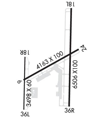
| Rwy | Rwy | |||||||
| 4163x100 | 4163' | 4163x100 | 4163' | |||||
| 6506x100 | 6506' | 110.90 - 182° | 6506x100 | 6506' | ||||
| 3498x60 | 3498' | 3498x60 | 3498' | |||||
| Runway ID | Single Wheel | Double Wheel | Double Tandem Wheel | Dual Double Wheel |
| 06/24 | 36,000 | 47,000 | 70,000 | N/A |
| 18L/36R | 80,000 | 99,500 | 150,000 | N/A |
| 18R/36L | 30,000 | 42,000 | 60,000 | N/A |
| These numbers are Advisory and are not limits. The Airport Manager should have more accurate Weight Limits | ||||
 Airport Diagram might not be current. | |
| Facility Name: | SOUTHERN ILLINOIS |
| City Name: | CARBONDALE/MURPHYSBORO |
| County: | JACKSON |
| State abbrev: | IL |
| State Name: | ILLINOIS |
| Ownership: | PUBLICLY OWNED |
| Use: | OPEN TO THE PUBLIC |
| Owner's Name: | SOUTHERN ILLINOIS ARPT AUTH |
| Address: | PO BOX 1086 |
| CARBONDALE, IL 62903 | |
| Owner's Phone: | 618-529-1721 |
| Manager's Name: | GARY R. SHAFER |
| Address: | P O BOX 1086 |
| CARBONDALE, IL 62903 | |
| Phone: | 618-529-1721 |
| FAA Region: | GREAT LAKES |
| FAA Field Office: | CHI |
| Date | Sunrise | Sunset |
|---|---|---|
| 09/24/21 Friday | 6:46 | 18:51 |
| 09/25/21 Saturday | 6:47 | 18:50 |
| 09/26/21 Sunday | 6:48 | 18:48 |
| 09/27/21 Monday | 6:49 | 18:47 |
| 09/28/21 Tuesday | 6:50 | 18:45 |
| 09/29/21 Wednesday | 6:51 | 18:43 |
| 09/30/21 Thursday | 6:51 | 18:42 |
| 10/01/21 Friday | 6:52 | 18:40 |
| 10/02/21 Saturday | 6:53 | 18:39 |
| 10/03/21 Sunday | 6:54 | 18:37 |
| 10/04/21 Monday | 6:55 | 18:36 |
| 10/05/21 Tuesday | 6:56 | 18:34 |
| 10/06/21 Wednesday | 6:57 | 18:33 |
| 10/07/21 Thursday | 6:58 | 18:31 |
| Airport Attendance Schedule | CONTINUOUS |
| Airport Status | OPERATIONAL (This Status can change at any time - please check NOTAMS) |
| Airport Lighting Schedule | ACTVT MALSR RWY 18L; VASI RWY 06; PAPI RWY 24 & 36R; MIRL RWY 06/24; HIRL RWY 18L/36R - CTAF. WHEN ATCT CLSD HIRL RWY 18L/36R PRESET MED INTST; INCREASE INTST - CTAF. WHEN ATCT CLSD 18R/36L LTG BY REQUEST ONLY - CALL 618-534-3662. |
| Airport Storage Available | Tie Downs, Hanger |
| Extra Services Available | Air Ambulance, Cargo Handling, Charter, Flight Instruction, Aircraft Rental, Aircraft Sales |
| Wind Indicator | YES - (lighted) |
| Control Tower | YES |
| CTAF Frequency | 125.350 |
| Unicom Frequency | 122.950 |
| Rotating Beacon Color | CLEAR-GREEN (Light Land Airport) |
| Segmented Circle | YES |
| Landing Fee | NO |
| Airport Inspected | FEDERAL - performed by FAA AIRPORTS FIELD PERSONNEL |
| Inspection Date | 03/12/2020 |
| Type of Fuel Available | Grade 100LL, JET A (freeze point -40C) |
| Airframe Repair Service | MAJOR |
| Power Plant Repair Service | MAJOR |
| Latitude | N3746.7 |
| Longitude | W08915.1 (ESTIMATED) |
| Arpt Elevation | 411ft (SURVEYED) |
| Magnetic Variation | 01W |
| 3 miles NW | of CARBONDALE/MURPHYSBORO |
| Traffic Pattern Altitude | |
| Sectional Chart | ST LOUIS |
| Operations (Reported) | Yearly | Avg. Daily |
|---|---|---|
| General Aviation Transient | 6773 | 19 |
| General Aviation Local | 67941 | 186 |
| Air Taxi | 24734 | 68 |
| Commerical | 31 | 0 |
| Commuter | 0 | 0 |
| Military | 125 | 0 |
| Aircraft based on Field | |
|---|---|
| General Aviation Singles | 62 |
| General Aviation Multi | 7 |
| Jet Aircraft | 1 |
| General Aviation Helicopters | 0 |
| Military Aircraft | 0 |
| Gliders | 0 |
| Ultralights | 0 |
| FSS on field | NO |
| FSS tie-in | SAINT LOUIS |
| FSS Phone | 1-800-WX-BRIEF |
| Who issues Notams | MDH |
| Notam D service at airport | YES |
| ARTCC Name | KANSAS CITY |
| Airport Certification | CLSD TO SKED ACR OPS GTR THAN 9 PSGR SEATS. UNSKED ACR OPS GTR THAN 30 PSGR SEATS RQR 24 HR PPR - CALL AMGR MON-FRI. |
| Aircraft Rescue & Firefighting Index | AIRPORT HAS A CERTIFICATE UNDER CFR PART 139 |
| Airport of Entry | No |
| Custom Landing Rights | No |
| Joint Civil/Military | No |
| Military Landing rights | YES |
| NATIONAL PLAN OF INTEGRATED AIRPORT SYSTEMS (NPIAS) |
| GRANT AGREEMENTS UNDER FAAP/ADAP/AIP |
| ASSURANCES PURSUANT TO TITLE VI, CIVIL RIGHTS ACT OF 1964 |
| BIRDS ON & INVOF ARPT. |
| HIGH STUDENT TRNG ACTVTY. |
| RWY 6 & RWY 18R-36L INTERSECT; VERIFY CORRECT COMPASS HDG FOR RWY 6 DEP. |
| RWY 06/2 4 RWY 06/24 NOT AVBL FOR UNSCHEDULED ACR AT LEAST 31 PSGR SEATS. |
| RWY 18R/ 36LRWY 18R/36L NOT AVBL FOR UNSCHEDULED ACR AT LEAST 31 PSGR SEATS. |
| RWY 06/2 4 RSTRD TO ACFT 12500 LBS OR LESS UNLESS PPR WITH ATCT. |
Airport Communications & Frequencies:
| |||||||||||||||||||
| Runway: 06 | Runway: 24 | ||
| Mag heading: | 62° | Mag heading: | 242° |
| Rwy Slope: | -.14% Down | Rwy Slope: | .14% Up |
| Approach: | Approach: | ||
| Pattern: | Left Traffic | Pattern: | Left Traffic |
| Markings: | BASIC | Markings: | BASIC |
| Marking Condition: | GOOD | Marking Condition: | GOOD |
| Arresting Dev: | Arresting Dev: | ||
| Lat & Long: | N3746.5 W08915.5 | Lat. & Long.: | N3746.9 W08914.8 |
| Elev: | 410.9 ft. MSL | Elev: | 405.0 ft. MSL |
| TCH: | 48 ft. AGL | TCH: | 25 ft. AGL |
| Visual Glide Path: | 3.50 degrees | Visual Glide Path: | 3.50 degrees |
| Displaced Threshold: | No | Displaced Threshold: | No |
| Touchdown Zone: | YES | Touchdown Zone: | YES |
| Touchdown Elev.: | 411.2 feet | Touchdown Elev.: | 408.7 feet |
| Visual Glide Slope: | 4-BOX VASI ON LEFT SIDE OF RUNWAY | Visual Glide Slope: | 4-Light PAPI on RIGHT side of Runway |
| RVR Equipment: | RVR Equipment: | ||
| RVV Equipment: | NO | RVV Equipment: | NO |
| Approach Lights: | Approach Lights: | ||
| REIL: | YES | REIL: | YES |
| Centerline Lights: | NO | Centerline Lights: | NO |
| Touchdown lights: | NO | Touchdown lights: | NO |
| Runway Category: | Runway with a Visual Approach | Runway Category: | Runway with a Visual Approach |
| Declared Distances: | TORA:4163' TODA:4163' ASDA:4164' LDA:4164' | Declared Distances: | TORA:4163' TODA:4163' ASDA:4164' LDA:4164' |
| Runway: 18L | Runway: 36R | ||
| Mag heading: | 182° | Mag heading: | 2° |
| Rwy Slope: | -.11% Down | Rwy Slope: | .11% Up |
| Approach: | ILS | Approach: | |
| Pattern: | Left Traffic | Pattern: | Left Traffic |
| Markings: | PRECISION INSTRUMENT | Markings: | NONPRECISION INSTRUMENT |
| Marking Condition: | GOOD | Marking Condition: | GOOD |
| Arresting Dev: | Arresting Dev: | ||
| Lat & Long: | N3747.3 W08914.9 | Lat. & Long.: | N3746.2 W08914.9 |
| Elev: | 404.1 ft. MSL | Elev: | 397.2 ft. MSL |
| TCH: | TCH: | 45 ft. AGL | |
| Visual Glide Path: | Visual Glide Path: | 3.00 degrees | |
| Displaced Threshold: | No | Displaced Threshold: | No |
| Touchdown Zone: | YES | Touchdown Zone: | YES |
| Touchdown Elev.: | 407.1 feet | Touchdown Elev.: | 405.5 feet |
| Visual Glide Slope: | Visual Glide Slope: | 4-Light PAPI on LEFT side of Runway | |
| RVR Equipment: | RVR Equipment: | ||
| RVV Equipment: | NO | RVV Equipment: | NO |
| Approach Lights: | MALSR - 1,400 foot medium intensity approach lighting system with runway alignment indicator lights | Approach Lights: | |
| REIL: | NO | REIL: | YES |
| Centerline Lights: | NO | Centerline Lights: | NO |
| Touchdown lights: | NO | Touchdown lights: | NO |
| Runway Category: | Precision Instrument Runway | Runway Category: | Runway with a Non-precision Approach having visibility minimums greater than 3/4 mile |
| Declared Distances: | TORA:6506' TODA:6506' ASDA:6506' LDA:6506' | Declared Distances: | TORA:6506' TODA:6506' ASDA:6506' LDA:6506' |
| Obstructions: | Obstructions: | 39 FT MKD PLINE 1872 FT FM RWY 192 FT L OF CNTRLN. APCH RATIO 42:1. | |
| Marked: | Marked: | NOT Marked/Lighted | |
| Clearance slope: | 50:1 | Clearance slope: | 34:1 |
| Obstruction height: | Obstruction height: | ||
| Dist. from runway: | Dist. from runway: | ||
| Centerline offset: | Centerline offset: | ||
| Comments: | Comments: |
| Runway: 18R | Runway: 36L | ||
| Mag heading: | 182° | Mag heading: | 2° |
| Rwy Slope: | .15% Up | Rwy Slope: | -.15% Down |
| Approach: | Approach: | ||
| Pattern: | Left Traffic | Pattern: | Left Traffic |
| Markings: | BASIC | Markings: | BASIC |
| Marking Condition: | GOOD | Marking Condition: | GOOD |
| Arresting Dev: | Arresting Dev: | ||
| Lat & Long: | N3746.8 W08915.5 | Lat. & Long.: | N3746.2 W08915.5 |
| Elev: | 404.8 ft. MSL | Elev: | 409.9 ft. MSL |
| TCH: | 27 ft. AGL | TCH: | 25 ft. AGL |
| Visual Glide Path: | 3.00 degrees | Visual Glide Path: | 3.00 degrees |
| Displaced Threshold: | No | Displaced Threshold: | No |
| Touchdown Zone: | YES | Touchdown Zone: | YES |
| Touchdown Elev.: | 411.2 feet | Touchdown Elev.: | 411.2 feet |
| Visual Glide Slope: | PULSATING/STEADY BURNING VASI ON LEFT SIDE OF RUNWAY; UNUSBL BYD 6 DEG RIGHT OF COURSE. PVASI OTS INDEF. | Visual Glide Slope: | PULSATING/STEADY BURNING VASI ON LEFT SIDE OF RUNWAY |
| RVR Equipment: | RVR Equipment: | ||
| RVV Equipment: | NO | RVV Equipment: | NO |
| Approach Lights: | Approach Lights: | ||
| REIL: | NO | REIL: | NO |
| Centerline Lights: | NO | Centerline Lights: | NO |
| Touchdown lights: | NO | Touchdown lights: | NO |
| Runway Category: | Runway with a Visual Approach | Runway Category: | Runway with a Visual Approach |
| Declared Distances: | TORA:3498' TODA:3498' ASDA:3498' LDA:3498' | Declared Distances: | TORA:3498' TODA:3498' ASDA:3498' LDA:3498' |
Thanks for using FltPlan.com
all rights reserved © 1999-2021 by Flight Plan LLC