
| GAINESVILLE RGNL GAINESVILLE FL |
| |
| Lat: N 2941.4 Long: W 08216.3 Elev: 151 Var: +04 Longest Runway: 7504 | ||
| Dept. ATIS: 127.15 Arr. ATIS: 127.15 AWOS: 127.15 Ground: 121.7 Tower: 119.55 | ||

| ||||||||||||||||||||||||||||||||||||||||||||
| ||||||||||||||||||||||||||||||||||||||||||||
| ||||||||||||||||||||||||||||||||||||||||||||
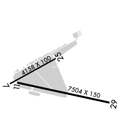
| Rwy | Rwy | |||||||
| 4158x100 | 4158' | 4158x100 | 4158' | |||||
| 7504x150 | 7504' | 7504x150 | 7504' | 111.30 - 286° | ||||
| Runway ID | Single Wheel | Double Wheel | Double Tandem Wheel | Dual Double Wheel |
| 07/25 | 83,000 | 137,000 | 227,000 | N/A |
| 11/29 | 118,000 | 195,000 | 331,000 | 796,000 |
| These numbers are Advisory and are not limits. The Airport Manager should have more accurate Weight Limits | ||||
 Airport Diagram might not be current. | |
| Facility Name: | GAINESVILLE RGNL |
| City Name: | GAINESVILLE |
| County: | ALACHUA |
| State abbrev: | FL |
| State Name: | FLORIDA |
| Ownership: | PUBLICLY OWNED |
| Use: | OPEN TO THE PUBLIC |
| Owner's Name: | GAINESVILLE-ALACHUA CO AUTH; GAINESVILLE-ALACHUA CO REGIONAL ARPT AUTHORITY |
| Address: | 3880 NE 39TH AVE |
| GAINESVILLE, FL 32609 | |
| Owner's Phone: | 352-373-0249 |
| Manager's Name: | ALLAN PENKSA |
| Address: | 3880 NE 39 AVE STE A |
| GAINESVILLE, FL 32609 | |
| Phone: | 352-373-0249 |
| FAA Region: | SOUTHERN |
| FAA Field Office: | ORL |
| Date | Sunrise | Sunset |
|---|---|---|
| 05/29/25 Thursday | 6:30 | 20:23 |
| 05/30/25 Friday | 6:30 | 20:24 |
| 05/31/25 Saturday | 6:29 | 20:24 |
| 06/01/25 Sunday | 6:29 | 20:25 |
| 06/02/25 Monday | 6:29 | 20:25 |
| 06/03/25 Tuesday | 6:29 | 20:26 |
| 06/04/25 Wednesday | 6:29 | 20:26 |
| 06/05/25 Thursday | 6:28 | 20:27 |
| 06/06/25 Friday | 6:28 | 20:27 |
| 06/07/25 Saturday | 6:28 | 20:28 |
| 06/08/25 Sunday | 6:28 | 20:28 |
| 06/09/25 Monday | 6:28 | 20:29 |
| 06/10/25 Tuesday | 6:28 | 20:29 |
| 06/11/25 Wednesday | 6:28 | 20:29 |
| Airport Attendance Schedule | CONTINUOUS |
| Airport Status | OPERATIONAL (This Status can change at any time - please check NOTAMS) |
| Airport Lighting Schedule | WHEN ATCT CLSD ACTVT MALSR RWY 29; MIRL RWY 07/25; HIRL RWY 11/29 - CTAF. |
| Airport Storage Available | Tie Downs, Hanger |
| Extra Services Available | Cargo Handling, Flight Instruction, Aircraft Rental, Aircraft Sales |
| Wind Indicator | YES - (lighted) |
| Control Tower | YES |
| CTAF Frequency | 119.550 |
| Unicom Frequency | 122.950 |
| Rotating Beacon Color | WG |
| Segmented Circle | YES |
| Landing Fee | NO |
| Airport Inspected | FEDERAL - performed by FAA AIRPORTS FIELD PERSONNEL |
| Inspection Date | 11/17/2023 |
| Type of Fuel Available | Grade 100, JET A (freeze point -40C) |
| Airframe Repair Service | MAJOR |
| Power Plant Repair Service | MAJOR |
| Latitude | N2941.4 |
| Longitude | W08216.3 (ESTIMATED) |
| Arpt Elevation | 151ft (SURVEYED) |
| Magnetic Variation | 04W |
| 3 miles NE | of GAINESVILLE |
| Traffic Pattern Altitude | |
| Sectional Chart | JACKSONVILLE |
| Operations (Reported) | Yearly | Avg. Daily |
|---|---|---|
| General Aviation Transient | 0 | 0 |
| General Aviation Local | 0 | 0 |
| Air Taxi | 0 | 0 |
| Commerical | 0 | 0 |
| Commuter | 0 | 0 |
| Military | 0 | 0 |
| Aircraft based on Field | |
|---|---|
| General Aviation Singles | 0 |
| General Aviation Multi | 0 |
| Jet Aircraft | 0 |
| General Aviation Helicopters | 0 |
| Military Aircraft | 0 |
| Gliders | 0 |
| Ultralights | 0 |
| FSS on field | NO |
| FSS tie-in | GAINESVILLE |
| FSS Phone | 1-800-WX-BRIEF |
| Who issues Notams | GNV |
| Notam D service at airport | YES |
| ARTCC Name | JACKSONVILLE |
| Airport Certification | AIRPORT RECEIVING SCHEDULED AIR CARRIER SERVICE FROM CARRIERS CERTIFICATED BY THE CIVIL AERONAUTICS BOARD; RWY 7/25 NOT AVBL FOR SKED ACR OPS WITH MORE THAN 9 PAX SEATS OR UNSKED ACR AT LEAST 31 PAX SEATS. |
| Aircraft Rescue & Firefighting Index | AIRPORT HAS A CERTIFICATE UNDER CFR PART 139 |
| Airport of Entry | No |
| Custom Landing Rights | No |
| Joint Civil/Military | No |
| Military Landing rights | YES |
| NATIONAL PLAN OF INTEGRATED AIRPORT SYSTEMS (NPIAS) |
| GRANT AGREEMENTS UNDER FAAP/ADAP/AIP |
| SURPLUS PROPERTY AGREEMENT UNDER PUBLIC LAW 289 |
| ASSURANCES PURSUANT TO TITLE VI, CIVIL RIGHTS ACT OF 1964 |
| AGREEMENT UNDER DLAND OR DCLA HAS EXPIRED. |
| THIS AIRPORT HAS BEEN SURVEYED BY THE NATIONAL GEODETIC SURVEY. |
| WHEN ATCT CLSD ACFT MORE THAN 12500 LBS CTC FBO FOR PRKG INSTR PRIOR TO EXITING TWY A DUE TO IREG PAVEMENT STRENGTHS - 352-335-4681. |
| GA RAMP LMTD TO ACFT 110,000 LB OR BLW; OTHERS PPR. |
| BANNER TOWING NA EXC 72 HR PPR - AMGR. |
| ARPT SFC COND NOT MNTD BTW 2330 - 0400 DLY. |
| FOR CD IF UNA TO CTC ON FSS FREQ, CTC JACKSONVILLE APCH AT 904-741-0284. |
| RWY 11-29 MRKGS ON W END ARE NOT STD DUE TO MRKGS NOT FULLY REMOVED/GHOSTING. |
| TWY B LMTD TO 75,000 LB OR BLW; OTHERS PPR |
| TWY C LMTD TO 120,000 LB OR BLW; OTHERS PPR |
| PORTIONS OF RWY 07/25 & NE 1000 FT OF TWY A NOT VSB FM ATCT; BLOCKED BY VORTAC BLDG. |
| WILDLIFE ON & INVOF ARPT. |
| RWY 07/2 5 ACR NA. |
| RWY 11/2 9 STD GROOVING FULL LENGTH AND 130 FT WIDE CENTER PORTION. |
| RWY 07/2 5 PCR VALUE: 320/F/B/X/T |
| RWY 11/2 9 PCR VALUE: 480/F/B/X/T |
Airport Communications & Frequencies:
| ||||||||||||||||||||||
| Runway: 07 | Runway: 25 | ||
| Mag heading: | 65° | Mag heading: | 245° |
| Rwy Slope: | -.51% Down | Rwy Slope: | .51% Up |
| Approach: | Approach: | ||
| Pattern: | Left Traffic | Pattern: | Left Traffic |
| Markings: | NONPRECISION INSTRUMENT | Markings: | NONPRECISION INSTRUMENT |
| Marking Condition: | GOOD | Marking Condition: | GOOD |
| Arresting Dev: | Arresting Dev: | ||
| Lat & Long: | N2941.4 W08216.9 | Lat. & Long.: | N2941.8 W08216.3 |
| Elev: | 151.4 ft. MSL | Elev: | 130.2 ft. MSL |
| TCH: | 44 ft. AGL | TCH: | 42 ft. AGL |
| Visual Glide Path: | 3.00 degrees | Visual Glide Path: | 3.00 degrees |
| Displaced Threshold: | No | Displaced Threshold: | No |
| Touchdown Zone: | YES | Touchdown Zone: | YES |
| Touchdown Elev.: | 151.4 feet | Touchdown Elev.: | 144.4 feet |
| Visual Glide Slope: | 4-Light PAPI on LEFT side of Runway | Visual Glide Slope: | 4-Light PAPI on LEFT side of Runway |
| RVR Equipment: | RVR Equipment: | ||
| RVV Equipment: | NO | RVV Equipment: | NO |
| Approach Lights: | Approach Lights: | ||
| REIL: | NO | REIL: | NO |
| Centerline Lights: | NO | Centerline Lights: | NO |
| Touchdown lights: | NO | Touchdown lights: | NO |
| Runway Category: | Runway with a Non-precision Approach having visibility minimums greater than 3/4 mile | Runway Category: | Runway with a Non-precision Approach having visibility minimums greater than 3/4 mile |
| Declared Distances: | Declared Distances: | ||
| Obstructions: | TREES | Obstructions: | TREES |
| Marked: | NOT Marked/Lighted | Marked: | NOT Marked/Lighted |
| Clearance slope: | 25:1 | Clearance slope: | 34:1 |
| Obstruction height: | 70 feet AGL | Obstruction height: | 34 feet AGL |
| Dist. from runway: | 2006 feet | Dist. from runway: | 1389 feet |
| Centerline offset: | 432 left of centerline | Centerline offset: | 423 feet left of centerline |
| Comments: | Comments: |
| Runway: 11 | Runway: 29 | ||
| Mag heading: | 106° | Mag heading: | 286° |
| Rwy Slope: | -.56% Down | Rwy Slope: | .56% Up |
| Approach: | Approach: | ILS | |
| Pattern: | Left Traffic | Pattern: | Left Traffic |
| Markings: | PRECISION INSTRUMENT | Markings: | PRECISION INSTRUMENT |
| Marking Condition: | GOOD | Marking Condition: | GOOD |
| Arresting Dev: | Arresting Dev: | ||
| Lat & Long: | N2941.4 W08216.8 | Lat. & Long.: | N2941.2 W08215.5 |
| Elev: | 147.4 ft. MSL | Elev: | 105.1 ft. MSL |
| TCH: | 54 ft. AGL | TCH: | 55 ft. AGL |
| Visual Glide Path: | 3.00 degrees | Visual Glide Path: | 3.00 degrees |
| Displaced Threshold: | No | Displaced Threshold: | No |
| Touchdown Zone: | YES | Touchdown Zone: | YES |
| Touchdown Elev.: | 147.4 feet | Touchdown Elev.: | 122.4 feet |
| Visual Glide Slope: | 4-Light PAPI on LEFT side of Runway | Visual Glide Slope: | 4-Light PAPI on RIGHT side of Runway |
| RVR Equipment: | ROLLOUT | RVR Equipment: | TOUCHDOWN |
| RVV Equipment: | NO | RVV Equipment: | NO |
| Approach Lights: | Approach Lights: | MALSR - 1,400 foot medium intensity approach lighting system with runway alignment indicator lights | |
| REIL: | YES | REIL: | NO |
| Centerline Lights: | NO | Centerline Lights: | NO |
| Touchdown lights: | NO | Touchdown lights: | NO |
| Runway Category: | Runway with a Non-precision Approach having visibility minimums greater than 3/4 mile | Runway Category: | Precision Instrument Runway |
| Declared Distances: | Declared Distances: | ||
| Obstructions: | TREES | Obstructions: | TREES |
| Marked: | NOT Marked/Lighted | Marked: | NOT Marked/Lighted |
| Clearance slope: | 31:1 | Clearance slope: | 49:1 |
| Obstruction height: | 81 feet AGL | Obstruction height: | 68 feet AGL |
| Dist. from runway: | 2783 feet | Dist. from runway: | 3535 feet |
| Centerline offset: | 626 right of centerline | Centerline offset: | 458 feet left of centerline |
| Comments: | Comments: |
Thanks for using FltPlan.com
all rights reserved © 1999-2025 by Flight Plan LLC
