
| FORT WAYNE INTL FORT WAYNE IN |
| |
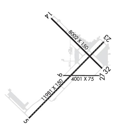
| Lat: N 4058.7 Long: W 08511.7 Elev: 815 Var: +06 Longest Runway: 11981 | ||
| Clr Del: 124.75 Dept. ATIS: 121.25 Arr. ATIS: 121.25 Ground: 121.9 Tower: 119.1 | ||
| ||||||||||||||||||||||||||||||||||||||||||||||||||||||||||||||||||||
| ||||||||||||||||||||||||||||||||||||||||||||||||||||||||||||||||||||
| ||||||||||||||||||||||||||||||||||||||||||||||||||||||||||||||||||||
| Rwy | Rwy | |||||||
| 11981x150 | 11981' | 111.90 - 050° | 11981x150 | 11981' | ||||
| 4001x75 | 4001' | 4001x75 | 4001' | |||||
| 8002x150 | 8002' | 8002x150 | 8002' | 109.90 - 320° | ||||
| Runway ID | Single Wheel | Double Wheel | Double Tandem Wheel | Dual Double Wheel |
| 05/23 | 120,000 | 203,000 | 357,000 | 847,000 |
| 09/27 | 100,000 | 190,000 | 215,000 | 430,000 |
| 14/32 | 120,000 | 189,000 | 326,000 | 799,000 |
| These numbers are Advisory and are not limits. The Airport Manager should have more accurate Weight Limits | ||||
 Airport Diagram might not be current. | |
| Facility Name: | FORT WAYNE INTL |
| City Name: | FORT WAYNE |
| County: | ALLEN |
| State abbrev: | IN |
| State Name: | INDIANA |
| Ownership: | PUBLICLY OWNED |
| Use: | OPEN TO THE PUBLIC |
| Owner's Name: | FT WAYNE/ALLEN CO ARPT AUTH |
| Address: | 3801 WEST FERGUSON ROAD, SUITE 209 |
| FORT WAYNE, IN 46809 | |
| Owner's Phone: | 260-747-4146 |
| Manager's Name: | SCOTT D. HINDERMAN |
| Address: | 3801 WEST FERGUSON ROAD, SUITE 209 |
| FORT WAYNE, IN 46809 | |
| Phone: | 260-747-4146 |
| FAA Region: | GREAT LAKES |
| FAA Field Office: | CHI |
| Date | Sunrise | Sunset |
|---|---|---|
| 09/24/21 Friday | 7:30 | 19:35 |
| 09/25/21 Saturday | 7:31 | 19:33 |
| 09/26/21 Sunday | 7:32 | 19:32 |
| 09/27/21 Monday | 7:33 | 19:30 |
| 09/28/21 Tuesday | 7:34 | 19:28 |
| 09/29/21 Wednesday | 7:35 | 19:26 |
| 09/30/21 Thursday | 7:36 | 19:25 |
| 10/01/21 Friday | 7:37 | 19:23 |
| 10/02/21 Saturday | 7:38 | 19:21 |
| 10/03/21 Sunday | 7:39 | 19:20 |
| 10/04/21 Monday | 7:40 | 19:18 |
| 10/05/21 Tuesday | 7:41 | 19:17 |
| 10/06/21 Wednesday | 7:42 | 19:15 |
| 10/07/21 Thursday | 7:43 | 19:13 |
| Airport Attendance Schedule | 7 Days A Week 0500-2300; AFT HR SVC - 260-747-2624. |
| Airport Status | OPERATIONAL (This Status can change at any time - please check NOTAMS) |
| Airport Lighting Schedule | ATC-CTL |
| Airport Storage Available | Tie Downs, Hanger |
| Extra Services Available | Air Freight, Air Ambulance, Avionics, Cargo Handling, Charter, Flight Instruction, Aircraft Rental, Aircraft Sales |
| Wind Indicator | YES - (lighted) |
| Control Tower | YES |
| CTAF Frequency | |
| Unicom Frequency | 122.950 |
| Rotating Beacon Color | CLEAR-GREEN (Light Land Airport) |
| Segmented Circle | NO |
| Landing Fee | NO |
| Airport Inspected | FEDERAL - performed by FAA AIRPORTS FIELD PERSONNEL |
| Inspection Date | 08/10/2018 |
| Type of Fuel Available | Grade 100LL, JET A (freeze point -40C), JET A; -10NC-100LL, A - CALLOUT FEE 0400-1000Z++. |
| Airframe Repair Service | MAJOR |
| Power Plant Repair Service | MAJOR |
| Latitude | N4058.7 |
| Longitude | W08511.7 (ESTIMATED) |
| Arpt Elevation | 814ft (SURVEYED) |
| Magnetic Variation | 06W |
| 7 miles SW | of FORT WAYNE |
| Traffic Pattern Altitude | |
| Sectional Chart | CHICAGO |
| Operations (Reported) | Yearly | Avg. Daily |
|---|---|---|
| General Aviation Transient | 12005 | 33 |
| General Aviation Local | 4910 | 13 |
| Air Taxi | 11056 | 30 |
| Commerical | 8288 | 23 |
| Commuter | 0 | 0 |
| Military | 2467 | 7 |
| Aircraft based on Field | |
|---|---|
| General Aviation Singles | 24 |
| General Aviation Multi | 6 |
| Jet Aircraft | 14 |
| General Aviation Helicopters | 1 |
| Military Aircraft | 21 |
| Gliders | 0 |
| Ultralights | 0 |
| FSS on field | NO |
| FSS tie-in | TERRE HAUTE |
| FSS Phone | 1-800-WX-BRIEF |
| Who issues Notams | FWA |
| Notam D service at airport | YES |
| ARTCC Name | CHICAGO |
| Airport Certification | AIRPORT RECEIVING SCHEDULED AIR CARRIER SERVICE FROM CARRIERS CERTIFICATED BY THE CIVIL AERONAUTICS BOARD; ARFF INDEX C AVBL UPON REQ - 260-747-2624. |
| Aircraft Rescue & Firefighting Index | AIRPORT HAS A CERTIFICATE UNDER CFR PART 139 |
| Airport of Entry | No |
| Custom Landing Rights | YES; US CUSTOMS FEE ARPT. |
| Joint Civil/Military | No |
| Military Landing rights | YES |
| NATIONAL PLAN OF INTEGRATED AIRPORT SYSTEMS (NPIAS) |
| GRANT AGREEMENTS UNDER FAAP/ADAP/AIP |
| SURPLUS PROPERTY AGREEMENT UNDER PUBLIC LAW 289 |
| ASSURANCES PURSUANT TO TITLE VI, CIVIL RIGHTS ACT OF 1964 |
| AGREEMENT UNDER DLAND OR DCLA HAS EXPIRED. |
| BIRDS ON & INVOF ARPT. |
| ANG: PRK RAMP NSTD MRK INCL SOLID WHITE WINGTIP CLNC LINES ON BOTH SIDES OF TAXILINE LCTD BTN EAST AND WEST PRK ROWS AND EAST AND WEST OF BLDG 800 (ACFT SHELTER), AND MULTIPLE WHITE BOXES FOR ACFT GRD EQPT (AGE) AND MUNITIONS STORAGE AREA. |
| ANG: UNUSE PAVEMENT FOR TAXIING ACFT LCTD CNTR OF APN WEST OF RSTD AREA. CTC OPS FOR FURTHER INFO. |
| TWY M & EAST RAMP MIL USE ONLY. OTHER ACFT BY REQUEST - ANG 260-478-3202. |
| TWY B ARM/DEARM AREA RSTRD TO MIL ACFT. |
| PPR FRM ATCT FOR ACFT PUSHBACK AT BOARDING GATES 2 & 3; PUSH BACK INTO TWY C MOVEMENT AREA. |
| OFFL BUS IN SUPPORT OF 122FW MSN ONLY, PPR DSN 778-3202/3203 C800-842-3104 EXTN 202/203. |
| TWYS B/B-1/B-2/E & K CLSD TO ACFT WITH WINGSPANS 79 FT & OVER & ACFT WITH DUAL WHEEL TYPE LANDING GEAR IN EXCESS OF 50000 LBS. |
| RWY 09/2 7 AVBL FOR TAXI ONLY AT NIGHT. AVBL FOR SKED ACR OPS WITH MORE THAN 9 PAX SEATS OR UNSKED ACR OPS WITH AT LEAST 31 PAX SEATS. |
Airport Communications & Frequencies:
| |||||||||||||||||||||||||||||||||||||||||||||||||||||
| Runway: 05 | Runway: 23 | ||
| Mag heading: | 50° | Mag heading: | 230° |
| Rwy Slope: | -.13% Down | Rwy Slope: | .13% Up |
| Approach: | ILS | Approach: | |
| Pattern: | Left Traffic | Pattern: | Left Traffic |
| Markings: | PRECISION INSTRUMENT | Markings: | PRECISION INSTRUMENT |
| Marking Condition: | GOOD | Marking Condition: | GOOD |
| Arresting Dev: | Arresting Dev: | ||
| Lat & Long: | N4057.8 W08512.8 | Lat. & Long.: | N4059.2 W08510.9 |
| Elev: | 814.5 ft. MSL | Elev: | 798.5 ft. MSL |
| TCH: | TCH: | 76 ft. AGL | |
| Visual Glide Path: | Visual Glide Path: | 3.00 degrees | |
| Displaced Threshold: | No | Displaced Threshold: | No |
| Touchdown Zone: | YES | Touchdown Zone: | YES |
| Touchdown Elev.: | 814.5 feet | Touchdown Elev.: | 799.1 feet |
| Visual Glide Slope: | Visual Glide Slope: | 4-Light PAPI on LEFT side of Runway | |
| RVR Equipment: | TOUCHDOWN-MIDFIELD-ROLLOUT | RVR Equipment: | TOUCHDOWN-MIDFIELD-ROLLOUT |
| RVV Equipment: | NO | RVV Equipment: | NO |
| Approach Lights: | ALSF2 - standard 2,400 foot high intensity approach lighting system with sequenced flashers, Category II or III | Approach Lights: | |
| REIL: | NO | REIL: | YES |
| Centerline Lights: | YES | Centerline Lights: | YES |
| Touchdown lights: | YES | Touchdown lights: | NO |
| Runway Category: | Precision Instrument Runway | Runway Category: | D |
| Declared Distances: | TORA:11981' TODA:11981' ASDA:11981' LDA:11981' | Declared Distances: | TORA:11981' TODA:11981' ASDA:11981' LDA:11981' |
| Obstructions: | Obstructions: | RR | |
| Marked: | Marked: | NOT Marked/Lighted | |
| Clearance slope: | 50:1 | Clearance slope: | 34:1 |
| Obstruction height: | Obstruction height: | 23 feet AGL | |
| Dist. from runway: | Dist. from runway: | 800 feet | |
| Centerline offset: | Centerline offset: | 585 feet left of centerline | |
| Comments: | Comments: |
| Runway: 09 | Runway: 27 | ||
| Mag heading: | 96° | Mag heading: | 276° |
| Rwy Slope: | -.12% Down | Rwy Slope: | .12% Up |
| Approach: | Approach: | ||
| Pattern: | Left Traffic | Pattern: | Left Traffic |
| Markings: | BASIC | Markings: | BASIC |
| Marking Condition: | GOOD | Marking Condition: | GOOD |
| Arresting Dev: | Arresting Dev: | ||
| Lat & Long: | N4058.6 W08511.9 | Lat. & Long.: | N4058.6 W08511.1 |
| Elev: | 798.4 ft. MSL | Elev: | 793.4 ft. MSL |
| TCH: | TCH: | ||
| Visual Glide Path: | Visual Glide Path: | ||
| Displaced Threshold: | No | Displaced Threshold: | No |
| Touchdown Zone: | YES | Touchdown Zone: | YES |
| Touchdown Elev.: | 799.4 feet | Touchdown Elev.: | 797.9 feet |
| Visual Glide Slope: | Visual Glide Slope: | ||
| RVR Equipment: | RVR Equipment: | ||
| RVV Equipment: | NO | RVV Equipment: | NO |
| Approach Lights: | Approach Lights: | ||
| REIL: | NO | REIL: | NO |
| Centerline Lights: | NO | Centerline Lights: | NO |
| Touchdown lights: | NO | Touchdown lights: | NO |
| Runway Category: | Runway with a Visual Approach | Runway Category: | Runway with a Visual Approach |
| Declared Distances: | TORA:4001' TODA:4001' ASDA:4001' LDA:4001' | Declared Distances: | TORA:4001' TODA:4001' ASDA:4001' LDA:4001' |
| Runway: 14 | Runway: 32 | ||
| Mag heading: | 141° | Mag heading: | 321° |
| Rwy Slope: | -.06% Down | Rwy Slope: | .06% Up |
| Approach: | Approach: | ILS/DME | |
| Pattern: | Left Traffic | Pattern: | Left Traffic |
| Markings: | PRECISION INSTRUMENT | Markings: | PRECISION INSTRUMENT |
| Marking Condition: | GOOD | Marking Condition: | GOOD |
| Arresting Dev: | Arresting Dev: | ||
| Lat & Long: | N4059.6 W08512.2 | Lat. & Long.: | N4058.7 W08511.0 |
| Elev: | 801.6 ft. MSL | Elev: | 796.4 ft. MSL |
| TCH: | 53 ft. AGL | TCH: | 76 ft. AGL |
| Visual Glide Path: | 3.00 degrees | Visual Glide Path: | 3.00 degrees |
| Displaced Threshold: | No | Displaced Threshold: | No |
| Touchdown Zone: | YES | Touchdown Zone: | YES |
| Touchdown Elev.: | 801.7 feet | Touchdown Elev.: | 800.4 feet |
| Visual Glide Slope: | 4-Light PAPI on LEFT side of Runway | Visual Glide Slope: | 4-Light PAPI on LEFT side of Runway |
| RVR Equipment: | ROLLOUT | RVR Equipment: | TOUCHDOWN |
| RVV Equipment: | NO | RVV Equipment: | NO |
| Approach Lights: | Approach Lights: | MALSR - 1,400 foot medium intensity approach lighting system with runway alignment indicator lights | |
| REIL: | YES | REIL: | NO |
| Centerline Lights: | NO | Centerline Lights: | NO |
| Touchdown lights: | NO | Touchdown lights: | NO |
| Runway Category: | D | Runway Category: | Precision Instrument Runway |
| Declared Distances: | TORA:8001' TODA:8001' ASDA:8001' LDA:8001' | Declared Distances: | TORA:8001' TODA:8001' ASDA:8001' LDA:8001' |
| Obstructions: | TREE | Obstructions: | RR |
| Marked: | NOT Marked/Lighted | Marked: | NOT Marked/Lighted |
| Clearance slope: | 34:1 | Clearance slope: | 50:1 |
| Obstruction height: | 100 feet AGL | Obstruction height: | 26 feet AGL |
| Dist. from runway: | 3672 feet | Dist. from runway: | 1084 feet |
| Centerline offset: | 809 right of centerline | Centerline offset: | 625 feet right of centerline |
| Comments: | Comments: |
Thanks for using FltPlan.com
all rights reserved © 1999-2021 by Flight Plan LLC


