
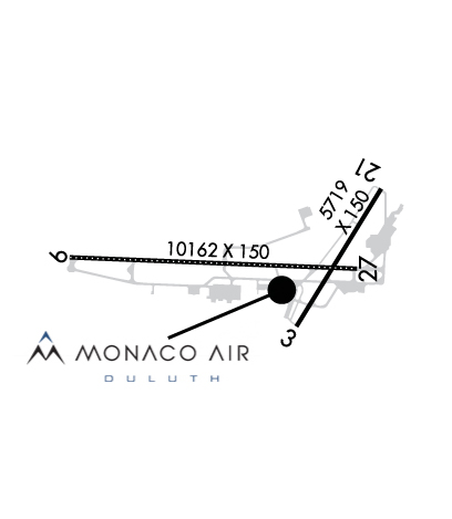
| DULUTH INTL DULUTH MN |
| |
| Lat: N 4650.5 Long: W 09211.6 Elev: 1428 Var: +01 Longest Runway: 10591 | ||
| Dept. ATIS: 124.1 Arr. ATIS: 124.1 Ground: 121.9 Tower: 118.3 | ||
| |||||||||||||||||||||||||||||||||||||||||||||||||||||||||||||||||||||
| |||||||||||||||||||||||||||||||||||||||||||||||||||||||||||||||||||||
| |||||||||||||||||||||||||||||||||||||||||||||||||||||||||||||||||||||
| FBOs at nearby airports who want your business: | |||||||||||||||||
| |||||||||||||||||
| Rwy | Rwy | |||||||
| 5719x150 | 5719' | 5719x150 | 5719' | |||||
| 10591x150 | 10591' | 110.30 - 093° | 10591x150 | 10062' | 108.70 - 273° | |||
| Runway ID | Single Wheel | Double Wheel | Double Tandem Wheel | Dual Double Wheel |
| 03/21 | 52,000 | 100,000 | 361,000 | N/A |
| 09/27 | 94,000 | 180,000 | 650,000 | N/A |
| These numbers are Advisory and are not limits. The Airport Manager should have more accurate Weight Limits | ||||
 Airport Diagram might not be current. | |
| Facility Name: | DULUTH INTL |
| City Name: | DULUTH |
| County: | ST LOUIS |
| State abbrev: | MN |
| State Name: | MINNESOTA |
| Ownership: | PUBLICLY OWNED |
| Use: | OPEN TO THE PUBLIC |
| Owner's Name: | CITY OF DULUTH, MINNESOTA |
| Address: | 4701 GRINDEN DR |
| DULUTH, MN 55811 | |
| Owner's Phone: | 218-625-7766 |
| Manager's Name: | TOM WERNER |
| Address: | 4701 GRINDEN DR |
| DULUTH, MN 55811 | |
| Phone: | 218-625-7767 |
| FAA Region: | GREAT LAKES |
| FAA Field Office: | DMA |
| Date | Sunrise | Sunset |
|---|---|---|
| 09/24/21 Friday | 6:58 | 19:03 |
| 09/25/21 Saturday | 6:59 | 19:01 |
| 09/26/21 Sunday | 7:01 | 18:59 |
| 09/27/21 Monday | 7:02 | 18:57 |
| 09/28/21 Tuesday | 7:03 | 18:55 |
| 09/29/21 Wednesday | 7:05 | 18:53 |
| 09/30/21 Thursday | 7:06 | 18:51 |
| 10/01/21 Friday | 7:07 | 18:49 |
| 10/02/21 Saturday | 7:09 | 18:47 |
| 10/03/21 Sunday | 7:10 | 18:45 |
| 10/04/21 Monday | 7:11 | 18:43 |
| 10/05/21 Tuesday | 7:13 | 18:41 |
| 10/06/21 Wednesday | 7:14 | 18:39 |
| 10/07/21 Thursday | 7:15 | 18:37 |
| Airport Attendance Schedule | CONTINUOUS |
| Airport Status | OPERATIONAL (This Status can change at any time - please check NOTAMS) |
| Airport Lighting Schedule | |
| Airport Storage Available | Tie Downs, Hanger |
| Extra Services Available | Air Freight, Cargo Handling, Charter, Flight Instruction, Aircraft Rental, Aircraft Sales |
| Wind Indicator | YES - (unlit) |
| Control Tower | YES |
| CTAF Frequency | |
| Unicom Frequency | 122.950 |
| Rotating Beacon Color | CLEAR-GREEN (Light Land Airport) |
| Segmented Circle | NO |
| Landing Fee | YES; LDG FEE FOR ALL COML ACFT & ALL ACFT OVR 12500 LB MAX LDG WT EXC ACFT OPRD OR CHTRD BY THE US GOVT OR THE STATE OF MINNESOTA. |
| Airport Inspected | FEDERAL - performed by FAA AIRPORTS FIELD PERSONNEL |
| Inspection Date | 09/26/2019 |
| Type of Fuel Available | Grade 100LL, JET A (freeze point -40C)J8; -J8AVBL AT MIL & CIVIL FUELING FACILITIES. |
| Airframe Repair Service | MAJOR |
| Power Plant Repair Service | MAJOR |
| Latitude | N4650.5 |
| Longitude | W09211.6 (ESTIMATED) |
| Arpt Elevation | 1427ft (SURVEYED) |
| Magnetic Variation | 01W |
| 5 miles NW | of DULUTH |
| Traffic Pattern Altitude | |
| Sectional Chart | GREEN BAY |
| Operations (Reported) | Yearly | Avg. Daily |
|---|---|---|
| General Aviation Transient | 22899 | 63 |
| General Aviation Local | 20692 | 57 |
| Air Taxi | 8790 | 24 |
| Commerical | 2079 | 6 |
| Commuter | 0 | 0 |
| Military | 4216 | 12 |
| Aircraft based on Field | |
|---|---|
| General Aviation Singles | 49 |
| General Aviation Multi | 10 |
| Jet Aircraft | 4 |
| General Aviation Helicopters | 4 |
| Military Aircraft | 22 |
| Gliders | 0 |
| Ultralights | 0 |
| FSS on field | NO |
| FSS tie-in | PRINCETON |
| FSS Phone | 1-800-WX-BRIEF |
| Who issues Notams | DLH |
| Notam D service at airport | YES |
| ARTCC Name | MINNEAPOLIS |
| Airport Certification | AIRPORT RECEIVING SCHEDULED AIR CARRIER SERVICE FROM CARRIERS CERTIFICATED BY THE CIVIL AERONAUTICS BOARD; ARFF INDEX D AVBL H24 WITH 2 HR PPR - CTC ANG 218-788-7434. |
| Aircraft Rescue & Firefighting Index | AIRPORT HAS A CERTIFICATE UNDER CFR PART 139 |
| Airport of Entry | YES |
| Custom Landing Rights | YES |
| Joint Civil/Military | No |
| Military Landing rights | YES |
| NATIONAL PLAN OF INTEGRATED AIRPORT SYSTEMS (NPIAS) |
| GRANT AGREEMENTS UNDER FAAP/ADAP/AIP |
| SURPLUS PROPERTY AGREEMENT UNDER PUBLIC LAW 289 |
| ASSURANCES PURSUANT TO TITLE VI, CIVIL RIGHTS ACT OF 1964 |
| AGREEMENT UNDER DLAND OR DCLA HAS EXPIRED. |
| BIRDS ON & INVOF ARPT. |
| JASU: 9(AM32A-60) 2(A/M32A-86) 2(MC-11) 6(MC-2A) (MIL). |
| SP DE-ICE LHOX LHNIT. |
| OIL: O-148(MIL). JOAP. |
| CAUTION: BIRD HAZ. (PHASE II CONDITIONS) EXISTS DUR 1 SEP THRU 31 OCT. CTC SOF/AFLD MGR/COMD POST FOR INFO. |
| FLIGHT NOTIFICATION SERVICE (ADCUS) AVBL. |
| TAXI LANE G MAY BE USED AS ALTERNATE TAXI ROUTE. |
| FUEL: A+, J8 (MONACO AIR DULUTH, C218-727-2911.) (NC-100LL, A). A++(MIL) (ANG, C218-788-7340). |
| PPR ALL ACFT. OPR 1200-2130Z++ MON-FRI, EXC HOL AND FLEX DAYS. LTD OPR HR AND TRAN SVC AVBL. CTC AFLD MGT DSN 825-7252, C218-788-7252, OPS DESK DSN 825-7399, C218-788-7399, COMD POST DSN 825-7370/7371, C218-788-7370/7371. FTR ACFT AND C12/C21 CARGO ACFT MAY ENTER ANG RAMP VIA TWY E OR H. ALL OTHER NON-FTR ACFT USE TWY F TO ENTER ANG RAMP. PER GIANT REPORT, TWY F CURRENTLY RSTD TO ONLY C17/C130 ACFT. ALL OTHER CARGO AMC ACFT MUST PARK AT MIDFIELD RAMP. ALL TRAN ACFT WILL CTC COMD POST 15 MIN PRIOR TO LDG. TRAN ACFT WILL CTC COMD POST BEFORE ENGINE STARTUP AND BEFORE TAXI. NO SVC AVAILABLE WHEN WIND CHILL EXCEEDS OR IS FCST TO EXCEED -30-F. FOR RCR INFO, AFLD STATUS AND CRASH RESCUE CAPABILITY CTC COMD POST OR TWR. NONSTD MRK FOR ALERT/MAINT VEH, ACFT GND EQPT PRK SPOTS. |
| TWY C BTWN TWY A & D CLSD 1 OCT THRU 30 APR. |
| ACFT DEICE TYPE 1 & 4 FLUID AVBL - CTC FBO C218-727-2911. |
| US CUST INTL AOE (NO FEES) AVBL H24 C218-720-5203 THEN PRESS 0. CUST CLEARING LCTD AT FBO. |
| FOR MIL TSNT ACFT PRKG, RFLG, & SER OFF ANG CTC FBO C218-727-2977 H24. |
| HIGH SPEED MIL JET TFC AT 3000 FT TO 3300 FT MSL IN AREA. |
| WHEN RWY 03/21 IN USE; TWY C NORTH OF RWY 09/27 MAY BE RESTRICTED BY ATC TO ACFT WITH WINGSPANS LESS THAN 49 FT. |
| RWY 27 CAUTION: WINDSHEAR/DOWNDRAFTS FINAL APCH. |
| RWY 03/2 1 WEIGHT BEARING STRENGTH - 2S127. |
| RWY 09/2 7 WEIGHT BEARING STRENGTH - 2S153. |
Airport Communications & Frequencies:
| |||||||||||||||||||||||||||||||||||
| Runway: 03 | Runway: 21 | ||
| Mag heading: | 33° | Mag heading: | 213° |
| Rwy Slope: | .04% Up | Rwy Slope: | -.04% Down |
| Approach: | Approach: | ||
| Pattern: | Left Traffic | Pattern: | Left Traffic |
| Markings: | NONPRECISION INSTRUMENT | Markings: | NONPRECISION INSTRUMENT |
| Marking Condition: | GOOD | Marking Condition: | GOOD |
| Arresting Dev: | Arresting Dev: | ||
| Lat & Long: | N4650.1 W09211.3 | Lat. & Long.: | N4650.9 W09210.6 |
| Elev: | 1413.7 ft. MSL | Elev: | 1416.0 ft. MSL |
| TCH: | 39 ft. AGL | TCH: | 37 ft. AGL |
| Visual Glide Path: | 3.00 degrees | Visual Glide Path: | 3.00 degrees |
| Displaced Threshold: | No | Displaced Threshold: | No |
| Touchdown Zone: | YES | Touchdown Zone: | YES |
| Touchdown Elev.: | 1420.1 feet | Touchdown Elev.: | 1420.1 feet |
| Visual Glide Slope: | 4-Light PAPI on LEFT side of Runway | Visual Glide Slope: | 4-Light PAPI on LEFT side of Runway |
| RVR Equipment: | RVR Equipment: | ||
| RVV Equipment: | NO | RVV Equipment: | NO |
| Approach Lights: | Approach Lights: | ||
| REIL: | YES | REIL: | YES |
| Centerline Lights: | NO | Centerline Lights: | NO |
| Touchdown lights: | NO | Touchdown lights: | NO |
| Runway Category: | Runway with a Non-precision Approach having visibility minimums greater than 3/4 mile | Runway Category: | Runway with a Non-precision Approach having visibility minimums greater than 3/4 mile |
| Declared Distances: | TORA:5719' TODA:5719' ASDA:5719' LDA:5719' | Declared Distances: | TORA:5719' TODA:5719' ASDA:5719' LDA:5719' |
| Obstructions: | TREE | Obstructions: | TREE |
| Marked: | NOT Marked/Lighted | Marked: | NOT Marked/Lighted |
| Clearance slope: | 39:1 | Clearance slope: | 36:1 |
| Obstruction height: | 51 feet AGL | Obstruction height: | 30 feet AGL |
| Dist. from runway: | 2194 feet | Dist. from runway: | 1289 feet |
| Centerline offset: | 217 right of centerline | Centerline offset: | 324 feet left of centerline |
| Comments: | Comments: |
| Runway: 09 | Runway: 27 | ||
| Mag heading: | 93° | Mag heading: | 273° |
| Rwy Slope: | -.08% Down | Rwy Slope: | .08% Up |
| Approach: | ILS | Approach: | ILS |
| Pattern: | Left Traffic | Pattern: | Left Traffic |
| Markings: | PRECISION INSTRUMENT | Markings: | PRECISION INSTRUMENT |
| Marking Condition: | GOOD | Marking Condition: | GOOD |
| Arresting Dev: | BAK-12,BAK-14; TYPE H BAK-12B(B) 1470 FT. | Arresting Dev: | BAK-12,BAK-14; TYPE H BAK 12B(B) 2544 FT. |
| Lat & Long: | N4650.5 W09213.2 | Lat. & Long.: | N4650.5 W09210.7 |
| Elev: | 1427.8 ft. MSL | Elev: | 1419.4 ft. MSL |
| TCH: | 70 ft. AGL | TCH: | 91 ft. AGL |
| Visual Glide Path: | 3.00 degrees | Visual Glide Path: | 3.00 degrees |
| Displaced Threshold: | No | Displaced Threshold: | 529 feet |
| Touchdown Zone: | YES | Touchdown Zone: | YES |
| Touchdown Elev.: | 1427.8 feet | Touchdown Elev.: | 1420.9 feet |
| Visual Glide Slope: | 4-Light PAPI on LEFT side of Runway | Visual Glide Slope: | 4-Light PAPI on LEFT side of Runway |
| RVR Equipment: | TOUCHDOWN-MIDFIELD-ROLLOUT | RVR Equipment: | TOUCHDOWN-MIDFIELD-ROLLOUT |
| RVV Equipment: | YES | RVV Equipment: | NO |
| Approach Lights: | ALSF2 - standard 2,400 foot high intensity approach lighting system with sequenced flashers, Category II or III | Approach Lights: | MALSR - 1,400 foot medium intensity approach lighting system with runway alignment indicator lights |
| REIL: | NO | REIL: | NO |
| Centerline Lights: | YES | Centerline Lights: | YES |
| Touchdown lights: | YES | Touchdown lights: | NO |
| Runway Category: | Precision Instrument Runway | Runway Category: | Precision Instrument Runway |
| Declared Distances: | TORA:10591' TODA:11152' ASDA:10062' LDA:10062' | Declared Distances: | TORA:10591' TODA:10591' ASDA:10591' LDA:10062' |
| Obstructions: | TREE | Obstructions: | TREE |
| Marked: | NOT Marked/Lighted | Marked: | NOT Marked/Lighted |
| Clearance slope: | 27:1 | Clearance slope: | 45:1 |
| Obstruction height: | 93 feet AGL | Obstruction height: | 26 feet AGL |
| Dist. from runway: | 2797 feet | Dist. from runway: | 1376 feet |
| Centerline offset: | 873 left of centerline | Centerline offset: | 133 feet left of centerline |
| Comments: | Comments: |
Thanks for using FltPlan.com
all rights reserved © 1999-2021 by Flight Plan LLC