
| JAMES M COX DAYTON INTL DAYTON OH |
| |
| Lat: N 3954.1 Long: W 08413.2 Elev: 1009 Var: +06 Longest Runway: 10901 | ||
| Clr Del: 121.75 Dept. ATIS: 125.8 Arr. ATIS: 125.8 Ground: 121.9 Tower: 119.9 | ||

| |||||||||||||||||||||||||||||||||||||||||||||||||||||||||||||||||||||
| |||||||||||||||||||||||||||||||||||||||||||||||||||||||||||||||||||||
| |||||||||||||||||||||||||||||||||||||||||||||||||||||||||||||||||||||
| |||||||||||||||||||||||||||||||||||||||||||||||||||||||||||||||||||||
| |||||||||||||||||||||||||||||||||||||||||||||||||||||||||||||||||||||
| Rwy | Rwy | |||||||
| 10901x150 | 10901' | 108.90 - 061° | 10901x150 | 10901' | 111.90 - 241° | |||
| 7285x150 | 7285' | 7285x150 | 7285' | 110.30 - 241° | ||||
| 8502x150 | 8502' | 108.30 - 184° | 8502x150 | 8502' | ||||
| Runway ID | Single Wheel | Double Wheel | Double Tandem Wheel | Dual Double Wheel |
| 06L/24R | 100,000 | 210,000 | 583,000 | 870,000 |
| 06R/24L | 100,000 | 210,000 | 583,000 | 870,000 |
| 18/36 | 100,000 | 210,000 | 583,000 | 870,000 |
| These numbers are Advisory and are not limits. The Airport Manager should have more accurate Weight Limits | ||||
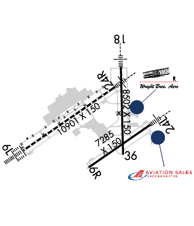 Airport Diagram might not be current. | |
| Facility Name: | JAMES M COX DAYTON INTL |
| City Name: | DAYTON |
| County: | MONTGOMERY |
| State abbrev: | OH |
| State Name: | OHIO |
| Ownership: | PUBLICLY OWNED |
| Use: | OPEN TO THE PUBLIC |
| Owner's Name: | CITY OF DAYTON, OHIO |
| Address: | 101 W 3RD ST |
| DAYTON, OH 45402-1859 | |
| Owner's Phone: | 937-333-3600 |
| Manager's Name: | GILBERT TURNER |
| Address: | 3600 TERMINAL DR STE 300 |
| VANDALIA, OH 45377-1095 | |
| Phone: | 937-454-8202 |
| FAA Region: | GREAT LAKES |
| FAA Field Office: | DET |
| Date | Sunrise | Sunset |
|---|---|---|
| 09/24/21 Friday | 7:26 | 19:31 |
| 09/25/21 Saturday | 7:27 | 19:29 |
| 09/26/21 Sunday | 7:28 | 19:28 |
| 09/27/21 Monday | 7:29 | 19:26 |
| 09/28/21 Tuesday | 7:30 | 19:24 |
| 09/29/21 Wednesday | 7:31 | 19:23 |
| 09/30/21 Thursday | 7:32 | 19:21 |
| 10/01/21 Friday | 7:33 | 19:20 |
| 10/02/21 Saturday | 7:34 | 19:18 |
| 10/03/21 Sunday | 7:35 | 19:16 |
| 10/04/21 Monday | 7:36 | 19:15 |
| 10/05/21 Tuesday | 7:37 | 19:13 |
| 10/06/21 Wednesday | 7:38 | 19:12 |
| 10/07/21 Thursday | 7:39 | 19:10 |
| Airport Attendance Schedule | CONTINUOUS |
| Airport Status | OPERATIONAL (This Status can change at any time - please check NOTAMS) |
| Airport Lighting Schedule | SS-SR |
| Airport Storage Available | Hanger |
| Extra Services Available | Air Freight, Avionics, Cargo Handling, Charter, Flight Instruction, Aircraft Rental, Aircraft Sales |
| Wind Indicator | YES - (lighted) |
| Control Tower | YES |
| CTAF Frequency | |
| Unicom Frequency | 122.950 |
| Rotating Beacon Color | CLEAR-GREEN (Light Land Airport) |
| Segmented Circle | NO |
| Landing Fee | NO |
| Airport Inspected | FEDERAL - performed by FAA AIRPORTS FIELD PERSONNEL |
| Inspection Date | 07/01/2021 |
| Type of Fuel Available | Grade 100, JET A (freeze point -40C) |
| Airframe Repair Service | MAJOR |
| Power Plant Repair Service | MAJOR |
| Latitude | N3954.1 |
| Longitude | W08413.2 (ESTIMATED) |
| Arpt Elevation | 1009ft (SURVEYED) |
| Magnetic Variation | 06W |
| 9 miles N | of DAYTON |
| Traffic Pattern Altitude | |
| Sectional Chart | CINCINNATI |
| Operations (Reported) | Yearly | Avg. Daily |
|---|---|---|
| General Aviation Transient | 10432 | 29 |
| General Aviation Local | 1700 | 5 |
| Air Taxi | 10586 | 29 |
| Commerical | 11226 | 31 |
| Commuter | 0 | 0 |
| Military | 791 | 2 |
| Aircraft based on Field | |
|---|---|
| General Aviation Singles | 13 |
| General Aviation Multi | 10 |
| Jet Aircraft | 11 |
| General Aviation Helicopters | 0 |
| Military Aircraft | 0 |
| Gliders | 0 |
| Ultralights | 0 |
| FSS on field | NO |
| FSS tie-in | DAYTON |
| FSS Phone | 1-800-WX-BRIEF |
| Who issues Notams | DAY |
| Notam D service at airport | YES |
| ARTCC Name | INDIANAPOLIS |
| Airport Certification | AIRPORT RECEIVING SCHEDULED AIR CARRIER SERVICE FROM CARRIERS CERTIFICATED BY THE CIVIL AERONAUTICS BOARD |
| Aircraft Rescue & Firefighting Index | AIRPORT HAS A CERTIFICATE UNDER CFR PART 139 |
| Airport of Entry | No |
| Custom Landing Rights | YES |
| Joint Civil/Military | No |
| Military Landing rights | YES |
| NATIONAL PLAN OF INTEGRATED AIRPORT SYSTEMS (NPIAS) |
| GRANT AGREEMENTS UNDER FAAP/ADAP/AIP |
| SURPLUS PROPERTY AGREEMENT UNDER PUBLIC LAW 289 |
| SURPLUS PROPERTY AGREEMENT UNDER REGULATION 16-WAA |
| CONVEYANCE UNDER SCETION 16, FEDERAL AIRPORT ACT OF 1946 OR SECTION 23, AIRPORT AND AIRWAY DEVELOPMENT ACT OF 1970 |
| ASSURANCES PURSUANT TO TITLE VI, CIVIL RIGHTS ACT OF 1964 |
| RUNUPS PROHIBITED IN RWY 24L HLDG AREA. |
| TWY W CLSD INDEFLY. TWYS Z, M, T, S CLSD BTN RWY 06L/24R AND TWY W INDEFLY. |
| DEER, COYOTES, BIRDS, & WATERFOWL ON & INVOF ARPT. |
| TWY C BTN TWY N & TWY Z NOT AVBL FOR GROUPS IV AND HIGHER. TWY K, TWY H & TWY J NOT AVBL FOR GROUP IV AND HIGHER ACFT. |
| RWY 06L/ 24RNE 1400 FT CONC, SW 9501 FT ASPH. |
Airport Communications & Frequencies:
| |||||||||||||||||||||||||||||||||||||||||||||
| Runway: 06L | Runway: 24R | ||
| Mag heading: | 61° | Mag heading: | 241° |
| Rwy Slope: | -.02% Down | Rwy Slope: | .02% Up |
| Approach: | ILS | Approach: | ILS/DME |
| Pattern: | Left Traffic | Pattern: | Left Traffic |
| Markings: | PRECISION INSTRUMENT | Markings: | PRECISION INSTRUMENT |
| Marking Condition: | GOOD | Marking Condition: | GOOD |
| Arresting Dev: | Arresting Dev: | ||
| Lat & Long: | N3953.7 W08414.8 | Lat. & Long.: | N3954.7 W08412.8 |
| Elev: | 997.9 ft. MSL | Elev: | 995.6 ft. MSL |
| TCH: | 67 ft. AGL | TCH: | 56 ft. AGL |
| Visual Glide Path: | 3.00 degrees | Visual Glide Path: | 3.00 degrees |
| Displaced Threshold: | No | Displaced Threshold: | No |
| Touchdown Zone: | YES | Touchdown Zone: | YES |
| Touchdown Elev.: | 997.9 feet | Touchdown Elev.: | 997.2 feet |
| Visual Glide Slope: | 4-Light PAPI on LEFT side of Runway | Visual Glide Slope: | 4-Light PAPI on LEFT side of Runway |
| RVR Equipment: | TOUCHDOWN-MIDFIELD-ROLLOUT | RVR Equipment: | TOUCHDOWN-MIDFIELD-ROLLOUT |
| RVV Equipment: | YES | RVV Equipment: | YES |
| Approach Lights: | ALSF2 - standard 2,400 foot high intensity approach lighting system with sequenced flashers, Category II or III | Approach Lights: | MALSR - 1,400 foot medium intensity approach lighting system with runway alignment indicator lights |
| REIL: | NO | REIL: | NO |
| Centerline Lights: | YES | Centerline Lights: | YES |
| Touchdown lights: | YES | Touchdown lights: | NO |
| Runway Category: | Precision Instrument Runway | Runway Category: | Precision Instrument Runway |
| Declared Distances: | TORA:10900' TODA:10900' ASDA:10900' LDA:10900' | Declared Distances: | TORA:10900' TODA:10900' ASDA:10900' LDA:10900' |
| Obstructions: | Obstructions: | TREE | |
| Marked: | Marked: | NOT Marked/Lighted | |
| Clearance slope: | 50:1 | Clearance slope: | 42:1 |
| Obstruction height: | Obstruction height: | 75 feet AGL | |
| Dist. from runway: | Dist. from runway: | 3417 feet | |
| Centerline offset: | Centerline offset: | 197 feet right of centerline | |
| Comments: | Comments: |
| Runway: 06R | Runway: 24L | ||
| Mag heading: | 61° | Mag heading: | 241° |
| Rwy Slope: | -.05% Down | Rwy Slope: | .05% Up |
| Approach: | Approach: | ILS/DME | |
| Pattern: | Left Traffic | Pattern: | Left Traffic |
| Markings: | PRECISION INSTRUMENT | Markings: | PRECISION INSTRUMENT |
| Marking Condition: | GOOD | Marking Condition: | GOOD |
| Arresting Dev: | Arresting Dev: | ||
| Lat & Long: | N3953.4 W08413.4 | Lat. & Long.: | N3954.1 W08412.1 |
| Elev: | 1005.0 ft. MSL | Elev: | 1001.1 ft. MSL |
| TCH: | 50 ft. AGL | TCH: | 54 ft. AGL |
| Visual Glide Path: | 3.00 degrees | Visual Glide Path: | 3.00 degrees |
| Displaced Threshold: | No | Displaced Threshold: | No |
| Touchdown Zone: | YES | Touchdown Zone: | YES |
| Touchdown Elev.: | 1009.1 feet | Touchdown Elev.: | 1006.9 feet |
| Visual Glide Slope: | 4-Light PAPI on LEFT side of Runway | Visual Glide Slope: | 4-Light PAPI on LEFT side of Runway |
| RVR Equipment: | RVR Equipment: | TOUCHDOWN | |
| RVV Equipment: | NO | RVV Equipment: | NO |
| Approach Lights: | Approach Lights: | MALSR - 1,400 foot medium intensity approach lighting system with runway alignment indicator lights | |
| REIL: | YES | REIL: | NO |
| Centerline Lights: | NO | Centerline Lights: | NO |
| Touchdown lights: | NO | Touchdown lights: | NO |
| Runway Category: | D | Runway Category: | Precision Instrument Runway |
| Declared Distances: | TORA:7285' TODA:7285' ASDA:7001' LDA:7001' | Declared Distances: | TORA:7285' TODA:7285' ASDA:7001' LDA:7001' |
| Obstructions: | TREE | Obstructions: | POLE |
| Marked: | NOT Marked/Lighted | Marked: | NOT Marked/Lighted |
| Clearance slope: | 20:1 | Clearance slope: | 39:1 |
| Obstruction height: | 51 feet AGL | Obstruction height: | 25 feet AGL |
| Dist. from runway: | 1230 feet | Dist. from runway: | 1194 feet |
| Centerline offset: | 517 right of centerline | Centerline offset: | 633 feet right of centerline |
| Comments: | Comments: |
| Runway: 18 | Runway: 36 | ||
| Mag heading: | 185° | Mag heading: | 5° |
| Rwy Slope: | .19% Up | Rwy Slope: | -.19% Down |
| Approach: | ILS | Approach: | |
| Pattern: | Left Traffic | Pattern: | Left Traffic |
| Markings: | PRECISION INSTRUMENT | Markings: | PRECISION INSTRUMENT |
| Marking Condition: | GOOD | Marking Condition: | GOOD |
| Arresting Dev: | Arresting Dev: | ||
| Lat & Long: | N3955.0 W08412.7 | Lat. & Long.: | N3953.6 W08412.7 |
| Elev: | 990.7 ft. MSL | Elev: | 1007.2 ft. MSL |
| TCH: | TCH: | 60 ft. AGL | |
| Visual Glide Path: | Visual Glide Path: | 3.00 degrees | |
| Displaced Threshold: | No | Displaced Threshold: | No |
| Touchdown Zone: | YES | Touchdown Zone: | YES |
| Touchdown Elev.: | 995.5 feet | Touchdown Elev.: | 1008.1 feet |
| Visual Glide Slope: | Visual Glide Slope: | 4-Light PAPI on LEFT side of Runway | |
| RVR Equipment: | TOUCHDOWN | RVR Equipment: | |
| RVV Equipment: | NO | RVV Equipment: | NO |
| Approach Lights: | MALSR - 1,400 foot medium intensity approach lighting system with runway alignment indicator lights | Approach Lights: | |
| REIL: | NO | REIL: | YES |
| Centerline Lights: | NO | Centerline Lights: | NO |
| Touchdown lights: | NO | Touchdown lights: | NO |
| Runway Category: | Precision Instrument Runway | Runway Category: | Runway with a Non-precision Approach having visibility minimums greater than 3/4 mile |
| Declared Distances: | TORA:8502' TODA:8502' ASDA:8502' LDA:8502' | Declared Distances: | TORA:8502' TODA:8502' ASDA:8502' LDA:8502' |
| Obstructions: | TREES | Obstructions: | TREES |
| Marked: | NOT Marked/Lighted | Marked: | NOT Marked/Lighted |
| Clearance slope: | 43:1 | Clearance slope: | 20:1 |
| Obstruction height: | 56 feet AGL | Obstruction height: | 41 feet AGL |
| Dist. from runway: | 2636 feet | Dist. from runway: | 1050 feet |
| Centerline offset: | 185 right of centerline | Centerline offset: | |
| Comments: | Comments: |
Thanks for using FltPlan.com
all rights reserved © 1999-2021 by Flight Plan LLC