
| HOUGHTON COUNTY MEMORIAL HANCOCK MI |
| |
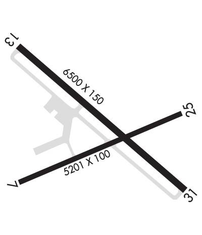
| Lat: N 4710.1 Long: W 08829.3 Elev: 1095 Var: +02 Longest Runway: 6501 | ||
| AWOS: 125.67 CTAF: 122.7 | ||
| ||||||||||||||||||||||||||||||||||||||||||||
| ||||||||||||||||||||||||||||||||||||||||||||
| ||||||||||||||||||||||||||||||||||||||||||||
| Rwy | Rwy | |||||||
| 5201x100 | 5201' | 5201x100 | 5201' | |||||
| 6501x150 | 6501' | 6501x150 | 6501' | 110.30 - 312° | ||||
| Runway ID | Single Wheel | Double Wheel | Double Tandem Wheel | Dual Double Wheel |
| 07/25 | 98,000 | 149,000 | 220,000 | N/A |
| 14/32 | 144,000 | 175,000 | 258,000 | N/A |
| These numbers are Advisory and are not limits. The Airport Manager should have more accurate Weight Limits | ||||
 Airport Diagram might not be current. | |
| Facility Name: | HOUGHTON COUNTY MEML |
| City Name: | HANCOCK |
| County: | HOUGHTON |
| State abbrev: | MI |
| State Name: | MICHIGAN |
| Ownership: | PUBLICLY OWNED |
| Use: | OPEN TO THE PUBLIC |
| Owner's Name: | HOUGHTON COUNTY |
| Address: | 23810 AIRPARK BLVD STE 113 |
| CALUMET, MI 49913-9233 | |
| Owner's Phone: | 906-482-3970 |
| Manager's Name: | CASEY J POLKINGHORNE |
| Address: | 23810 AIRPARK BLVD STE 113 |
| CALUMET, MI 49913-9233 | |
| Phone: | 906-482-3970; CELL 906-231-2256. |
| FAA Region: | GREAT LAKES |
| FAA Field Office: | DET |
| Date | Sunrise | Sunset |
|---|---|---|
| 05/03/26 Sunday | 6:35 | 21:07 |
| 05/04/26 Monday | 6:34 | 21:09 |
| 05/05/26 Tuesday | 6:32 | 21:10 |
| 05/06/26 Wednesday | 6:31 | 21:11 |
| 05/07/26 Thursday | 6:29 | 21:13 |
| 05/08/26 Friday | 6:28 | 21:14 |
| 05/09/26 Saturday | 6:26 | 21:15 |
| 05/10/26 Sunday | 6:25 | 21:17 |
| 05/11/26 Monday | 6:23 | 21:18 |
| 05/12/26 Tuesday | 6:22 | 21:19 |
| 05/13/26 Wednesday | 6:21 | 21:20 |
| 05/14/26 Thursday | 6:19 | 21:22 |
| 05/15/26 Friday | 6:18 | 21:23 |
| 05/16/26 Saturday | 6:17 | 21:24 |
| Airport Attendance Schedule | 7 Days A Week 0400-0000 |
| Airport Status | OPERATIONAL (This Status can change at any time - please check NOTAMS) |
| Airport Lighting Schedule | ACTVT MALSR RWY 32; REIL RWY 14; PAPI RWY 14 & 32; HIRL RWY 14/32 - CTAF. ACTVT REIL RWY 07 & 25; PAPI RWY 07 & 25; MIRL RWY 07/25; TWY B - CTC CO MAINT VIA CTAF. |
| Airport Storage Available | Hanger |
| Extra Services Available | Flight Instruction |
| Wind Indicator | YES - (lighted) |
| Control Tower | NO |
| CTAF Frequency | 122.700 |
| Unicom Frequency | 122.700 |
| Rotating Beacon Color | WG |
| Segmented Circle | NO |
| Landing Fee | NO |
| Airport Inspected | FEDERAL - performed by FAA AIRPORTS FIELD PERSONNEL |
| Inspection Date | 05/22/2025 |
| Type of Fuel Available | Grade 100LL, JET A (freeze point -40C) |
| Airframe Repair Service | MAJOR |
| Power Plant Repair Service | MAJOR; RPRS AVBL ON REQ - CALL AMGR. |
| Latitude | N4710.1 |
| Longitude | W08829.3 (ESTIMATED) |
| Arpt Elevation | 1095ft (SURVEYED) |
| Magnetic Variation | 02W |
| 4 miles NE | of HANCOCK |
| Traffic Pattern Altitude | |
| Sectional Chart | GREEN BAY |
| Operations (Reported) | Yearly | Avg. Daily |
|---|---|---|
| General Aviation Transient | 0 | 0 |
| General Aviation Local | 0 | 0 |
| Air Taxi | 0 | 0 |
| Commerical | 0 | 0 |
| Commuter | 0 | 0 |
| Military | 0 | 0 |
| Aircraft based on Field | |
|---|---|
| General Aviation Singles | 0 |
| General Aviation Multi | 0 |
| Jet Aircraft | 0 |
| General Aviation Helicopters | 0 |
| Military Aircraft | 0 |
| Gliders | 0 |
| Ultralights | 0 |
| FSS on field | NO |
| FSS tie-in | GREEN BAY |
| FSS Phone | 1-800-WX-BRIEF |
| Who issues Notams | CMX |
| Notam D service at airport | YES |
| ARTCC Name | MINNEAPOLIS |
| Airport Certification | AIRPORT RECEIVING SCHEDULED AIR CARRIER SERVICE FROM CARRIERS CERTIFICATED BY THE CIVIL AERONAUTICS BOARD; ARPT CLSD TO UNSKED ACR OPS WITH GTR THAN 30 PAX SEATS EXC PPR CALL AMGR. |
| Aircraft Rescue & Firefighting Index | AIRPORT HAS A CERTIFICATE UNDER CFR PART 139 |
| Airport of Entry | No |
| Custom Landing Rights | No |
| Joint Civil/Military | No |
| Military Landing rights | YES |
| NATIONAL PLAN OF INTEGRATED AIRPORT SYSTEMS (NPIAS) |
| GRANT AGREEMENTS UNDER FAAP/ADAP/AIP |
| ASSURANCES PURSUANT TO TITLE VI, CIVIL RIGHTS ACT OF 1964 |
| DEER & GULLS ON & INVOF ARPT. |
| AIRFIELD GUIDANCE SIGNS SNOW COVD IN WINTER. |
| PAEW ON ARPT MONITOR CTAF. FQT SNOW REMOVAL OPS IN PROGRESS AT VARIOUS TIMES OCT-APR MONITOR CTAF. |
| PPR VIA UNICOM FOR PRKG IN FRONT OF AIRLINE TRML. |
| FOR CD IF UNA TO CTC ON FSS FREQ, CTC MINNEAPOLIS ARTCC AT 651-463-5588. |
| RWY CONDS UNMON DLY 0000-0500. |
| RWY 07/2 5 PCR VALUE: 390/F/C/X/T |
| RWY 14/3 2 PCR VALUE: 470/F/C/X/T |
Airport Communications & Frequencies:
| |||||||||
| Runway: 07 | Runway: 25 | ||
| Mag heading: | 69° | Mag heading: | 249° |
| Rwy Slope: | .30% Up | Rwy Slope: | -.30% Down |
| Approach: | Approach: | ||
| Pattern: | Left Traffic | Pattern: | Left Traffic |
| Markings: | NONPRECISION INSTRUMENT | Markings: | NONPRECISION INSTRUMENT |
| Marking Condition: | GOOD | Marking Condition: | GOOD |
| Arresting Dev: | Arresting Dev: | ||
| Lat & Long: | N4709.9 W08829.9 | Lat. & Long.: | N4710.2 W08828.8 |
| Elev: | 1058.9 ft. MSL | Elev: | 1074.4 ft. MSL |
| TCH: | 30 ft. AGL | TCH: | 41 ft. AGL |
| Visual Glide Path: | 3.00 degrees | Visual Glide Path: | 3.00 degrees |
| Displaced Threshold: | No | Displaced Threshold: | No |
| Touchdown Zone: | YES | Touchdown Zone: | YES |
| Touchdown Elev.: | 1066.6 feet | Touchdown Elev.: | 1074.4 feet |
| Visual Glide Slope: | 2-Light PAPI on LEFT side of Runway | Visual Glide Slope: | 4-Light PAPI on LEFT side of Runway |
| RVR Equipment: | RVR Equipment: | ||
| RVV Equipment: | NO | RVV Equipment: | NO |
| Approach Lights: | Approach Lights: | ||
| REIL: | YES | REIL: | YES |
| Centerline Lights: | NO | Centerline Lights: | NO |
| Touchdown lights: | NO | Touchdown lights: | NO |
| Runway Category: | Runway with a Non-precision Approach having visibility minimums greater than 3/4 mile | Runway Category: | Runway with a Non-precision Approach having visibility minimums greater than 3/4 mile |
| Declared Distances: | TORA:5201' TODA:5201' ASDA:5201' LDA:5201' | Declared Distances: | TORA:5201' TODA:5201' ASDA:5201' LDA:5201' |
| Obstructions: | TREES | Obstructions: | TREES |
| Marked: | NOT Marked/Lighted | Marked: | NOT Marked/Lighted |
| Clearance slope: | 26:1 | Clearance slope: | 28:1 |
| Obstruction height: | 55 feet AGL | Obstruction height: | 51 feet AGL |
| Dist. from runway: | 1660 feet | Dist. from runway: | 1630 feet |
| Centerline offset: | 465 left of centerline | Centerline offset: | 250 feet left of centerline |
| Comments: | Comments: |
| Runway: 14 | Runway: 32 | ||
| Mag heading: | 133° | Mag heading: | 313° |
| Rwy Slope: | -.53% Down | Rwy Slope: | .53% Up |
| Approach: | Approach: | ILS/DME | |
| Pattern: | Left Traffic | Pattern: | Left Traffic |
| Markings: | PRECISION INSTRUMENT | Markings: | PRECISION INSTRUMENT |
| Marking Condition: | GOOD | Marking Condition: | GOOD |
| Arresting Dev: | Arresting Dev: | ||
| Lat & Long: | N4710.5 W08829.9 | Lat. & Long.: | N4709.8 W08828.7 |
| Elev: | 1095.1 ft. MSL | Elev: | 1060.7 ft. MSL |
| TCH: | 43 ft. AGL | TCH: | 46 ft. AGL |
| Visual Glide Path: | 3.00 degrees | Visual Glide Path: | 3.00 degrees |
| Displaced Threshold: | No | Displaced Threshold: | No |
| Touchdown Zone: | YES | Touchdown Zone: | YES |
| Touchdown Elev.: | 1095.1 feet | Touchdown Elev.: | 1070.3 feet |
| Visual Glide Slope: | 4-Light PAPI on LEFT side of Runway | Visual Glide Slope: | 4-Light PAPI on LEFT side of Runway |
| RVR Equipment: | RVR Equipment: | ||
| RVV Equipment: | NO | RVV Equipment: | NO |
| Approach Lights: | Approach Lights: | MALSR - 1,400 foot medium intensity approach lighting system with runway alignment indicator lights | |
| REIL: | YES | REIL: | NO |
| Centerline Lights: | NO | Centerline Lights: | NO |
| Touchdown lights: | NO | Touchdown lights: | NO |
| Runway Category: | Runway with a Non-precision Approach having visibility minimums greater than 3/4 mile | Runway Category: | Precision Instrument Runway |
| Declared Distances: | TORA:6501' TODA:6501' ASDA:6501' LDA:6501' | Declared Distances: | TORA:6501' TODA:6501' ASDA:6501' LDA:6501' |
| Obstructions: | TREES | Obstructions: | |
| Marked: | NOT Marked/Lighted | Marked: | |
| Clearance slope: | 22:1 | Clearance slope: | 50:1 |
| Obstruction height: | 73 feet AGL | Obstruction height: | |
| Dist. from runway: | 1872 feet | Dist. from runway: | |
| Centerline offset: | 715 right of centerline | Centerline offset: | |
| Comments: | Comments: |
Thanks for using FltPlan.com
all rights reserved © 1999-2026 by Flight Plan LLC