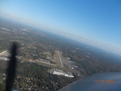
| CRYSTAL RIVER CRYSTAL RIVER FL |
| |
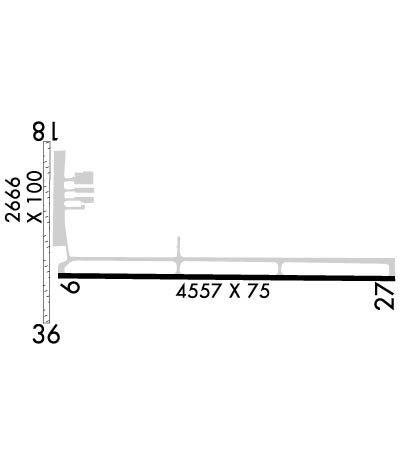
| Lat: N 2852.1 Long: W 08234.4 Elev: 9 Var: +05 Longest Runway: 4557 | ||
| AWOS: 118.32 CTAF: 122.72 | ||
| |||||||||||||||||||||||||||||||||||||||||||||||||||||||||||||
| |||||||||||||||||||||||||||||||||||||||||||||||||||||||||||||
| |||||||||||||||||||||||||||||||||||||||||||||||||||||||||||||
| Rwy | Rwy | |||||||
| 4557x75 | 4557' | 4557x75 | 4557' | |||||
| 2666x100 | 2474' | 2666x100 | 1847' | |||||
| Runway ID | Single Wheel | Double Wheel | Double Tandem Wheel | Dual Double Wheel |
| 09/27 | 68,000 | 97,000 | N/A | N/A |
| 18/36 | N/A | N/A | N/A | N/A |
| These numbers are Advisory and are not limits. The Airport Manager should have more accurate Weight Limits | ||||
 Airport Diagram might not be current. | |
| Facility Name: | CRYSTAL RIVER-CAPT TOM DAVIS FLD |
| City Name: | CRYSTAL RIVER |
| County: | CITRUS |
| State abbrev: | FL |
| State Name: | FLORIDA |
| Ownership: | PUBLICLY OWNED |
| Use: | OPEN TO THE PUBLIC |
| Owner's Name: | CITRUS COUNTY; CONTACT PERSON: QUINCY WYLUPEK 3600 WEST SOVEREIGN PATH, SUITE 241, LACANTO FL, 34461 352-527-5488 FAX; 352-527-5482 |
| Address: | 110 NORTH APOPKA AVE |
| INVERNESS, FL 34450 | |
| Owner's Phone: | 352-637-9400 |
| Manager's Name: | QUINCY WYLUPEK; AIRPORT PHYSICAL ADDRESS: 718 NORTH LINDBERGH DRIVE, CRYSTAL RIVER, FL 34429 352-795-6868 FAX: 352-795-1730 |
| Address: | PO BOX 2050 |
| CRYSTAL RIVER, FL 34423 | |
| Phone: | (352) 527-5488 |
| FAA Region: | SOUTHERN |
| FAA Field Office: | ORL |
| Date | Sunrise | Sunset |
|---|---|---|
| 09/24/21 Friday | 7:20 | 19:25 |
| 09/25/21 Saturday | 7:20 | 19:23 |
| 09/26/21 Sunday | 7:21 | 19:22 |
| 09/27/21 Monday | 7:21 | 19:21 |
| 09/28/21 Tuesday | 7:22 | 19:20 |
| 09/29/21 Wednesday | 7:22 | 19:19 |
| 09/30/21 Thursday | 7:23 | 19:17 |
| 10/01/21 Friday | 7:23 | 19:16 |
| 10/02/21 Saturday | 7:24 | 19:15 |
| 10/03/21 Sunday | 7:24 | 19:14 |
| 10/04/21 Monday | 7:25 | 19:13 |
| 10/05/21 Tuesday | 7:25 | 19:12 |
| 10/06/21 Wednesday | 7:26 | 19:11 |
| 10/07/21 Thursday | 7:27 | 19:09 |
| Airport Attendance Schedule | 7 Days A Week 0800-1800 |
| Airport Status | OPERATIONAL (This Status can change at any time - please check NOTAMS) |
| Airport Lighting Schedule | ACTVT REIL RWY 09, 27; MIRL RWY 09/27 - CTAF. |
| Airport Storage Available | Tie Downs |
| Extra Services Available | Charter, Flight Instruction, Aircraft Rental, Aircraft Sales |
| Wind Indicator | YES - (lighted) |
| Control Tower | NO |
| CTAF Frequency | 122.725 |
| Unicom Frequency | 122.725 |
| Rotating Beacon Color | CLEAR-GREEN (Light Land Airport) |
| Segmented Circle | Y-L |
| Landing Fee | NO |
| Airport Inspected | STATE - performed by STATE AERONAUTICAL PERSONNEL |
| Inspection Date | 09/20/2018 |
| Type of Fuel Available | Grade 100LL, JET A (freeze point -40C) |
| Airframe Repair Service | MINOR |
| Power Plant Repair Service | MINOR |
| Latitude | N2852.1 |
| Longitude | W08234.4 (ESTIMATED) |
| Arpt Elevation | 8ft (SURVEYED) |
| Magnetic Variation | 05W |
| 3 miles SE | of CRYSTAL RIVER |
| Traffic Pattern Altitude | |
| Sectional Chart | JACKSONVILLE |
| Operations (Reported) | Yearly | Avg. Daily |
|---|---|---|
| General Aviation Transient | 4380 | 12 |
| General Aviation Local | 23360 | 64 |
| Air Taxi | 416 | 1 |
| Commerical | 0 | 0 |
| Commuter | 0 | 0 |
| Military | 156 | 0 |
| Aircraft based on Field | |
|---|---|
| General Aviation Singles | 26 |
| General Aviation Multi | 1 |
| Jet Aircraft | 1 |
| General Aviation Helicopters | 0 |
| Military Aircraft | 0 |
| Gliders | 0 |
| Ultralights | 0 |
| FSS on field | NO |
| FSS tie-in | SAINT PETERSBURG |
| FSS Phone | 1-800-WX-BRIEF |
| Who issues Notams | CGC |
| Notam D service at airport | YES |
| ARTCC Name | JACKSONVILLE |
| Airport Certification | |
| Aircraft Rescue & Firefighting Index | None |
| Airport of Entry | No |
| Custom Landing Rights | No |
| Joint Civil/Military | No |
| Military Landing rights | No |
| NATIONAL PLAN OF INTEGRATED AIRPORT SYSTEMS (NPIAS) |
| GLIDER OPNS WITHIN 25 NM. |
| BLDG 30-80' WEST OF RWY END. |
| AEROBATIC ACTVT ALONG N SIDE OF RWY 09/27 & 4 NM SW OF ARPT. CTC UNICOM FOR TFC INFO, AND NOTAMS OR FSS FOR SPECIFIC TIMES. |
| RWY 27 TREES ON BOTH SIDES OF RWY IN TRANSITION SFC. |
| FOR CD CTC JACKSONVILLE APCH AT 904-741-0284. |
Airport Communications & Frequencies:
| ||||||||||||||
| Runway: 09 | Runway: 27 | ||
| Mag heading: | 96° | Mag heading: | 276° |
| Rwy Slope: | .03% Up | Rwy Slope: | -.03% Down |
| Approach: | Approach: | ||
| Pattern: | Left Traffic | Pattern: | Left Traffic |
| Markings: | NONPRECISION INSTRUMENT | Markings: | NONPRECISION INSTRUMENT |
| Marking Condition: | GOOD | Marking Condition: | GOOD |
| Arresting Dev: | Arresting Dev: | ||
| Lat & Long: | N2852.0 W08234.7 | Lat. & Long.: | N2852.0 W08233.9 |
| Elev: | 6.6 ft. MSL | Elev: | 7.8 ft. MSL |
| TCH: | 44 ft. AGL | TCH: | 43 ft. AGL |
| Visual Glide Path: | 3.00 degrees | Visual Glide Path: | 3.00 degrees |
| Displaced Threshold: | No | Displaced Threshold: | No |
| Touchdown Zone: | YES | Touchdown Zone: | YES |
| Touchdown Elev.: | 8.9 feet | Touchdown Elev.: | 8.9 feet |
| Visual Glide Slope: | 4-Light PAPI on LEFT side of Runway | Visual Glide Slope: | 2-Light PAPI on RIGHT side of Runway |
| RVR Equipment: | RVR Equipment: | ||
| RVV Equipment: | NO | RVV Equipment: | NO |
| Approach Lights: | Approach Lights: | ||
| REIL: | YES | REIL: | YES |
| Centerline Lights: | NO | Centerline Lights: | NO |
| Touchdown lights: | NO | Touchdown lights: | NO |
| Runway Category: | Runway with a Non-precision Approach | Runway Category: | Runway with a Non-precision Approach |
| Declared Distances: | Declared Distances: | ||
| Obstructions: | TREES | Obstructions: | TREES |
| Marked: | NOT Marked/Lighted | Marked: | NOT Marked/Lighted |
| Clearance slope: | APCH SLOPE 27:1 TO DISP THLD DUE TO 55 FT TREES 1,285 FT FRM RWY END 265 LEFT OF CNTRLN. | Clearance slope: | 9:1 |
| Obstruction height: | 15 feet AGL | Obstruction height: | 26 feet AGL |
| Dist. from runway: | 270 feet | Dist. from runway: | 430 feet |
| Centerline offset: | 212 right of centerline | Centerline offset: | 210 feet right of centerline |
| Comments: | 25FT TREES 212 FT SOUTH OF CNTRLN, 270 FT AFT THE AER RWY 9. | Comments: |
| Runway: 18 | Runway: 36 | ||
| Mag heading: | 185° | Mag heading: | 5° |
| Rwy Slope: | -.02% Down | Rwy Slope: | .02% Up |
| Approach: | Approach: | ||
| Pattern: | Left Traffic | Pattern: | Left Traffic |
| Markings: | Markings: | ||
| Marking Condition: | 18/36 MKD WITH WHITE PIPES EVERY 200 FT. | Marking Condition: | |
| Arresting Dev: | Arresting Dev: | ||
| Lat & Long: | N2852.3 W08234.7 | Lat. & Long.: | N2851.9 W08234.7 |
| Elev: | 6.1 ft. MSL | Elev: | 5.7 ft. MSL |
| TCH: | TCH: | ||
| Visual Glide Path: | Visual Glide Path: | ||
| Displaced Threshold: | 192 feet; 18/36 DSPLCD THRS MKD WITH GREEN PIPES. BLDGS & FENCE 40 FT FROM CNTRLN BOTH SIDES OF DSPLCD THLD. | Displaced Threshold: | 819 feet |
| Touchdown Zone: | YES | Touchdown Zone: | YES |
| Touchdown Elev.: | 6.1 feet | Touchdown Elev.: | 6.1 feet |
| Visual Glide Slope: | Visual Glide Slope: | ||
| RVR Equipment: | RVR Equipment: | ||
| RVV Equipment: | NO | RVV Equipment: | NO |
| Approach Lights: | Approach Lights: | ||
| REIL: | NO | REIL: | NO |
| Centerline Lights: | NO | Centerline Lights: | NO |
| Touchdown lights: | NO | Touchdown lights: | NO |
| Runway Category: | Runway with a Visual Approach | Runway Category: | Runway with a Visual Approach |
| Declared Distances: | Declared Distances: | ||
| Obstructions: | BLDG | Obstructions: | FENCE |
| Marked: | NOT Marked/Lighted | Marked: | NOT Marked/Lighted |
| Clearance slope: | 6:1; RWY 18 APCH RATIO 19:1 TO DSPLCD THLD. | Clearance slope: | 2:1; RWY 36 APCH RATIO 20:1 TO DSPLCD THLD DUE TO 64 FT TREES 460 FT FROM END OF RWY 100 FT LEFT. |
| Obstruction height: | 15 feet AGL | Obstruction height: | 6 feet AGL |
| Dist. from runway: | 92 feet | Dist. from runway: | 17 feet |
| Centerline offset: | 85 right of centerline | Centerline offset: | |
| Comments: | Comments: |
Thanks for using FltPlan.com
all rights reserved © 1999-2021 by Flight Plan LLC