
| BERT MOONEY BUTTE MT |
| |
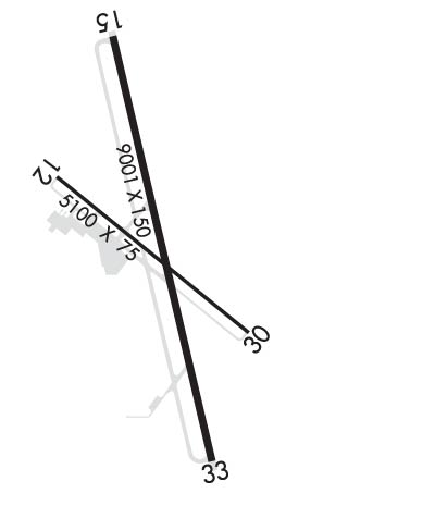
| Lat: N 4557.3 Long: W 11229.8 Elev: 5551 Var: -12 Longest Runway: 9000 | ||
| AWOS: 135.17 CTAF: 123.0 | ||
| ||||||||||||||||||||||||||||||||||||||||||||
| ||||||||||||||||||||||||||||||||||||||||||||
| ||||||||||||||||||||||||||||||||||||||||||||
| Rwy | Rwy | |||||||
| 5100x75 | 5100' | 5100x75 | 5100' | |||||
| 9000x150 | 9000' | 110.90 - 154° | 9000x150 | 9000' | ||||
| Runway ID | Single Wheel | Double Wheel | Double Tandem Wheel | Dual Double Wheel |
| 12/30 | 12,500 | N/A | N/A | N/A |
| 15/33 | 60,000 | 125,000 | 175,000 | N/A |
| These numbers are Advisory and are not limits. The Airport Manager should have more accurate Weight Limits | ||||
 Airport Diagram might not be current. | |
| Facility Name: | BERT MOONEY |
| City Name: | BUTTE |
| County: | SILVER BOW |
| State abbrev: | MT |
| State Name: | MONTANA |
| Ownership: | PUBLICLY OWNED |
| Use: | OPEN TO THE PUBLIC |
| Owner's Name: | BERT MOONEY, ARPT AUTH |
| Address: | 101 AIRPORT ROAD |
| BUTTE, MT 59701 | |
| Owner's Phone: | 406-494-3771 |
| Manager's Name: | PAM CHAMBERLIN |
| Address: | 101 AIRPORT RD |
| BUTTE, MT 59701 | |
| Phone: | 406-494-3771 |
| FAA Region: | NORTHWEST MOUNTAIN |
| FAA Field Office: | HLN |
| Date | Sunrise | Sunset |
|---|---|---|
| 09/24/21 Friday | 7:19 | 19:24 |
| 09/25/21 Saturday | 7:20 | 19:22 |
| 09/26/21 Sunday | 7:22 | 19:20 |
| 09/27/21 Monday | 7:23 | 19:18 |
| 09/28/21 Tuesday | 7:24 | 19:16 |
| 09/29/21 Wednesday | 7:26 | 19:14 |
| 09/30/21 Thursday | 7:27 | 19:12 |
| 10/01/21 Friday | 7:28 | 19:10 |
| 10/02/21 Saturday | 7:29 | 19:08 |
| 10/03/21 Sunday | 7:31 | 19:07 |
| 10/04/21 Monday | 7:32 | 19:05 |
| 10/05/21 Tuesday | 7:33 | 19:03 |
| 10/06/21 Wednesday | 7:35 | 19:01 |
| 10/07/21 Thursday | 7:36 | 18:59 |
| Airport Attendance Schedule | 7 Days A Week DAWN-DUSK |
| Airport Status | OPERATIONAL (This Status can change at any time - please check NOTAMS) |
| Airport Lighting Schedule | ACTVT MALSR RWY 15; REIL RWY 12 & 30; PAPI RWY 12 & 30; VASI RWY 33; MIRL RWY 15/33 & 12/30 - CTAF. PAPI RWY 15 OPR CONSLY. |
| Airport Storage Available | Tie Downs, Hanger |
| Extra Services Available | Air Freight, Charter, Flight Instruction, Aircraft Rental, Aircraft Sales |
| Wind Indicator | YES - (lighted) |
| Control Tower | NO |
| CTAF Frequency | 123.000 |
| Unicom Frequency | 123.000 |
| Rotating Beacon Color | CLEAR-GREEN (Light Land Airport) |
| Segmented Circle | YES |
| Landing Fee | YES; FEE FOR ALL COMMERCIAL ACFT & ACFT OVER 10000 LBS. |
| Airport Inspected | FEDERAL - performed by FAA AIRPORTS FIELD PERSONNEL |
| Inspection Date | 05/15/2019 |
| Type of Fuel Available | Grade 100, Grade 100LL, JET A (freeze point -40C) |
| Airframe Repair Service | MAJOR |
| Power Plant Repair Service | MAJOR |
| Latitude | N4557.3 |
| Longitude | W11229.8 (ESTIMATED) |
| Arpt Elevation | 5550ft (SURVEYED) |
| Magnetic Variation | 12E |
| 3 miles SE | of BUTTE |
| Traffic Pattern Altitude | |
| Sectional Chart | GREAT FALLS |
| Operations (Reported) | Yearly | Avg. Daily |
|---|---|---|
| General Aviation Transient | 7300 | 20 |
| General Aviation Local | 13340 | 37 |
| Air Taxi | 1920 | 5 |
| Commerical | 821 | 2 |
| Commuter | 0 | 0 |
| Military | 625 | 2 |
| Aircraft based on Field | |
|---|---|
| General Aviation Singles | 24 |
| General Aviation Multi | 9 |
| Jet Aircraft | 0 |
| General Aviation Helicopters | 3 |
| Military Aircraft | 0 |
| Gliders | 0 |
| Ultralights | 0 |
| FSS on field | NO |
| FSS tie-in | GREAT FALLS |
| FSS Phone | 1-800-WX-BRIEF |
| Who issues Notams | BTM |
| Notam D service at airport | YES |
| ARTCC Name | SALT LAKE CITY |
| Airport Certification | AIRPORT RECEIVING SCHEDULED AIR CARRIER SERVICE FROM CARRIERS CERTIFICATED BY THE CIVIL AERONAUTICS BOARD; PPR FOR UNSKED ACR OPNS WITH MORE THAN 30 PSGR SEATS CALL AMGR 406-494-3771. |
| Aircraft Rescue & Firefighting Index | AIRPORT HAS A CERTIFICATE UNDER CFR PART 139 |
| Airport of Entry | No |
| Custom Landing Rights | YES |
| Joint Civil/Military | No |
| Military Landing rights | YES |
| NATIONAL PLAN OF INTEGRATED AIRPORT SYSTEMS (NPIAS) |
| GRANT AGREEMENTS UNDER FAAP/ADAP/AIP |
| ASSURANCES PURSUANT TO TITLE VI, CIVIL RIGHTS ACT OF 1964 |
| AGREEMENT UNDER DLAND OR DCLA HAS EXPIRED. |
| FOR CD IF UNA TO CTC ON FSS FREQ, CTC SALT LAKE ARTCC AT 801-320-2568. |
| TWY D RSTD TO ACFT WITH WINGSPAN LESS THAN 100 FT WO PPR, CALL APMGR 406-494-3771. |
| DEER IN VICINITY OF AIRPORT. |
| SNOW REMOVAL OPS IN PROGRES DURING PERIODS OF SNOW. |
| COLD TEMPERATURE AIRPORT. ALTITUDE CORRECTION REQUIRED AT OR BELOW -25C. |
| RWY 12/3 0 SURFACE CONDITIONS UNMONITORED BETWEEN MIDNIGHT AND 5 A.M. |
Airport Communications & Frequencies:
| |||||||||
| Runway: 12 | Runway: 30 | ||
| Mag heading: | 117° | Mag heading: | 297° |
| Rwy Slope: | .19% Up | Rwy Slope: | -.19% Down |
| Approach: | Approach: | ||
| Pattern: | Left Traffic | Pattern: | Left Traffic |
| Markings: | BASIC | Markings: | BASIC |
| Marking Condition: | GOOD | Marking Condition: | GOOD |
| Arresting Dev: | Arresting Dev: | ||
| Lat & Long: | N4557.5 W11230.3 | Lat. & Long.: | N4557.0 W11229.4 |
| Elev: | 5520.7 ft. MSL | Elev: | 5530.6 ft. MSL |
| TCH: | 39 ft. AGL | TCH: | 46 ft. AGL |
| Visual Glide Path: | 4.00 degrees | Visual Glide Path: | 4.00 degrees |
| Displaced Threshold: | No | Displaced Threshold: | No |
| Touchdown Zone: | YES | Touchdown Zone: | YES |
| Touchdown Elev.: | 5533.5 feet | Touchdown Elev.: | 5534.9 feet |
| Visual Glide Slope: | 2-Light PAPI on LEFT side of Runway; PAPI STAIGHT-IN ONLY. | Visual Glide Slope: | 2-Light PAPI on LEFT side of Runway; PAPI RSTRD TO 2.1 NM FM RY 30 THLD DUE TO HIGH TERRAIN. |
| RVR Equipment: | RVR Equipment: | ||
| RVV Equipment: | NO | RVV Equipment: | NO |
| Approach Lights: | Approach Lights: | ||
| REIL: | YES | REIL: | YES |
| Centerline Lights: | NO | Centerline Lights: | NO |
| Touchdown lights: | NO | Touchdown lights: | NO |
| Runway Category: | Runway with a Visual Approach | Runway Category: | Runway with a Visual Approach |
| Declared Distances: | TORA:5100' TODA:5100' ASDA:5100' LDA:5100' | Declared Distances: | TORA:5100' TODA:5100' ASDA:5100' LDA:5100' |
| Obstructions: | ROAD | Obstructions: | BLDG |
| Marked: | NOT Marked/Lighted | Marked: | NOT Marked/Lighted |
| Clearance slope: | 22:1 | Clearance slope: | 29:1 |
| Obstruction height: | 16 feet AGL | Obstruction height: | 36 feet AGL |
| Dist. from runway: | 560 feet | Dist. from runway: | 1251 feet |
| Centerline offset: | 275 right of centerline | Centerline offset: | 100 feet right of centerline |
| Comments: | Comments: |
| Runway: 15 | Runway: 33 | ||
| Mag heading: | 155° | Mag heading: | 335° |
| Rwy Slope: | .49% Up | Rwy Slope: | -.49% Down |
| Approach: | ILS/DME | Approach: | |
| Pattern: | Right Traffic | Pattern: | Left Traffic |
| Markings: | PRECISION INSTRUMENT | Markings: | BASIC |
| Marking Condition: | GOOD | Marking Condition: | GOOD |
| Arresting Dev: | Arresting Dev: | ||
| Lat & Long: | N4558.0 W11230.1 | Lat. & Long.: | N4556.6 W11229.6 |
| Elev: | 5506.7 ft. MSL | Elev: | 5550.4 ft. MSL |
| TCH: | 55 ft. AGL | TCH: | 74 ft. AGL |
| Visual Glide Path: | 3.50 degrees | Visual Glide Path: | 3.00 degrees |
| Displaced Threshold: | No | Displaced Threshold: | No |
| Touchdown Zone: | YES | Touchdown Zone: | YES |
| Touchdown Elev.: | 5523.2 feet | Touchdown Elev.: | 5550.5 feet |
| Visual Glide Slope: | 4-Light PAPI on LEFT side of Runway | Visual Glide Slope: | 2-Box VASI on LEFT side of Runway; DO NOT USE VASI BYD 1.5 MI DUE TO HIGH TERRAIN. |
| RVR Equipment: | RVR Equipment: | ||
| RVV Equipment: | NO | RVV Equipment: | NO |
| Approach Lights: | MALSR - 1,400 foot medium intensity approach lighting system with runway alignment indicator lights | Approach Lights: | |
| REIL: | NO | REIL: | NO |
| Centerline Lights: | NO | Centerline Lights: | NO |
| Touchdown lights: | NO | Touchdown lights: | NO |
| Runway Category: | Precision Instrument Runway | Runway Category: | Runway with a Visual Approach |
| Declared Distances: | TORA:9000' TODA:9000' ASDA:9000' LDA:9000' | Declared Distances: | TORA:9000' TODA:9000' ASDA:9000' LDA:9000' |
| Obstructions: | Obstructions: | TOWER | |
| Marked: | Marked: | NOT Marked/Lighted | |
| Clearance slope: | 50:1 | Clearance slope: | 42:1 |
| Obstruction height: | Obstruction height: | 65 feet AGL | |
| Dist. from runway: | Dist. from runway: | 2986 feet | |
| Centerline offset: | Centerline offset: | 248 feet right of centerline | |
| Comments: | Comments: |
Thanks for using FltPlan.com
all rights reserved © 1999-2021 by Flight Plan LLC
