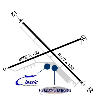
| WESTERN NEB. RGNL/HEILIG SCOTTSBLUFF NE |
| |
| Lat: N 4152.4 Long: W 10335.7 Elev: 3967 Var: -10 Longest Runway: 8279 | ||
| AWOS: 121.02 CTAF: 123.0 | ||
| |||||||||||||||||||||||||||||||||||||||||||||||||||||||||||||||||||||
| |||||||||||||||||||||||||||||||||||||||||||||||||||||||||||||||||||||
| |||||||||||||||||||||||||||||||||||||||||||||||||||||||||||||||||||||
| |||||||||||||||||||||||||||||||||||||||||||||||||||||||||||||||||||||
| Rwy | Rwy | |||||||
| 8002x150 | 8002' | 8002x150 | 8002' | |||||
| 8279x150 | 8279' | 110.35 - 125° | 8279x150 | 8279' | 109.30 - 305° | |||
| Runway ID | Single Wheel | Double Wheel | Double Tandem Wheel | Dual Double Wheel |
| 05/23 | 98,000 | 158,000 | 285,000 | N/A |
| 12/30 | 109,000 | 178,000 | 321,000 | N/A |
| These numbers are Advisory and are not limits. The Airport Manager should have more accurate Weight Limits | ||||
 Airport Diagram might not be current. | |
| Facility Name: | SCOTTSBLUFF/WESTERN NEBRASKA RGNL/WM B HEILIG FLD |
| City Name: | SCOTTSBLUFF |
| County: | SCOTTS BLUFF |
| State abbrev: | NE |
| State Name: | NEBRASKA |
| Ownership: | PUBLICLY OWNED |
| Use: | OPEN TO THE PUBLIC |
| Owner's Name: | AIRPORT AUTHORITY OF SCOTTSBLUFF CO |
| Address: | 250023 AIRPORT TERMINAL ST., SUITE 10 |
| SCOTTSBLUFF, NE 69361 | |
| Owner's Phone: | 308-635-4941 |
| Manager's Name: | RAUL AGUALLO |
| Address: | 250023 AIRPORT TERMINAL ST., SUITE 10 |
| SCOTTSBLUFF, NE 69361 | |
| Phone: | (308) 631-7449; CELL PHONE 308-631-8098 OR 308-631-1591. |
| FAA Region: | CENTRAL |
| FAA Field Office: | NONE |
| Date | Sunrise | Sunset |
|---|---|---|
| 04/01/26 Wednesday | 6:38 | 19:20 |
| 04/02/26 Thursday | 6:36 | 19:21 |
| 04/03/26 Friday | 6:34 | 19:22 |
| 04/04/26 Saturday | 6:32 | 19:23 |
| 04/05/26 Sunday | 6:31 | 19:24 |
| 04/06/26 Monday | 6:29 | 19:25 |
| 04/07/26 Tuesday | 6:27 | 19:26 |
| 04/08/26 Wednesday | 6:26 | 19:27 |
| 04/09/26 Thursday | 6:24 | 19:29 |
| 04/10/26 Friday | 6:23 | 19:30 |
| 04/11/26 Saturday | 6:21 | 19:31 |
| 04/12/26 Sunday | 6:19 | 19:32 |
| 04/13/26 Monday | 6:18 | 19:33 |
| 04/14/26 Tuesday | 6:16 | 19:34 |
| Airport Attendance Schedule | 7 Days A Week 0600-2100; FOR SVC AFTER HRS CALL 308-635-0162. |
| Airport Status | OPERATIONAL (This Status can change at any time - please check NOTAMS) |
| Airport Lighting Schedule | ACTVT MIRL RY 05/23; HIRL RY 12/30; MALSR RYS 12 & 30 & VASI RY 05 & PAPI RYS 12 , 23 AND 30 - CTAF. |
| Airport Storage Available | Tie Downs, Hanger |
| Extra Services Available | Air Freight, Crop Dusting, Charter, Glider, Flight Instruction, Aircraft Sales, Annual Surveying, Glider Towing |
| Wind Indicator | YES - (lighted) |
| Control Tower | NO |
| CTAF Frequency | 123.000; PER AMGR USE CTAF WHEN OPERATING ON THE ARPT. |
| Unicom Frequency | 123.000 |
| Rotating Beacon Color | WG |
| Segmented Circle | NO |
| Landing Fee | NO |
| Airport Inspected | FEDERAL - performed by FAA AIRPORTS FIELD PERSONNEL |
| Inspection Date | 05/15/2025 |
| Type of Fuel Available | Grade 100LL, JET A (freeze point -40C) |
| Airframe Repair Service | MAJOR |
| Power Plant Repair Service | MAJOR |
| Latitude | N4152.4 |
| Longitude | W10335.7 (ESTIMATED) |
| Arpt Elevation | 3967ft (SURVEYED) |
| Magnetic Variation | 10E |
| 3 miles E | of SCOTTSBLUFF |
| Traffic Pattern Altitude | |
| Sectional Chart | CHEYENNE |
| Operations (Reported) | Yearly | Avg. Daily |
|---|---|---|
| General Aviation Transient | 0 | 0 |
| General Aviation Local | 0 | 0 |
| Air Taxi | 0 | 0 |
| Commerical | 0 | 0 |
| Commuter | 0 | 0 |
| Military | 0 | 0 |
| Aircraft based on Field | |
|---|---|
| General Aviation Singles | 0 |
| General Aviation Multi | 0 |
| Jet Aircraft | 0 |
| General Aviation Helicopters | 0 |
| Military Aircraft | 0 |
| Gliders | 0 |
| Ultralights | 0 |
| FSS on field | NO |
| FSS tie-in | COLUMBUS |
| FSS Phone | 1-800-WX-BRIEF |
| Who issues Notams | BFF |
| Notam D service at airport | YES |
| ARTCC Name | DENVER |
| Airport Certification | AIRPORT RECEIVING SCHEDULED AIR CARRIER SERVICE FROM CARRIERS CERTIFICATED BY THE CIVIL AERONAUTICS BOARD; PPR 24 HRS FOR ACR OPNS WITH MORE THAN 30 PSGR SEATS CALL AMGR 308-635-4941. AIR CARRIER OPS OVER 9 PASSENGER SEATS NOT AUTHORIZED IN EXCESS OF 15 MINUTES BEFORE OR AFTER SCHEDULED ARRIVAL/DEP TIMES EXCEPT WITH PRIOR COORDINATION WITH AIRPORT MGR. ARFF INDEX B EQUIPMENT IS PROVIDED. |
| Aircraft Rescue & Firefighting Index | AIRPORT HAS A CERTIFICATE UNDER CFR PART 139 |
| Airport of Entry | No |
| Custom Landing Rights | No |
| Joint Civil/Military | No |
| Military Landing rights | YES |
| NATIONAL PLAN OF INTEGRATED AIRPORT SYSTEMS (NPIAS) |
| GRANT AGREEMENTS UNDER FAAP/ADAP/AIP |
| SURPLUS PROPERTY AGREEMENT UNDER REGULATION 16-WAA |
| ASSURANCES PURSUANT TO TITLE VI, CIVIL RIGHTS ACT OF 1964 |
| RY 30 DESIGNATED CALM WIND RY. |
| WATERFOWL ON & INVOF ARPT. |
| LINE OF SITE RESTRICTIONS BTWN APCH ENDS OF RYS 05 & 30 & ALSO BTWN THE APCH ENDS OF RYS 12 & 23. |
| APRON PAVEMENT STRENGTH, S-85, D-117, DT-232. PCN IS 31/R/A/W/T. |
| AC AND DC GROUND POWER UNITS AVAILABLE |
| LAVATORY SERVICE AVAILABLE |
| FOR CD CTC DENVER ARTCC ON FREQ. IF UNA, CTC FSS ON FREQ VIA RCO. IF UNA, CTC DENVER ARTCC AT 303-651-4257. |
| RWY 05/2 3 PCR VALUE: 2472/F/C/X/T |
| RWY 12/3 0 PCR VALUE: 2472/F/C/X/T |
Airport Communications & Frequencies:
| |||||||||
| Runway: 05 | Runway: 23 | ||
| Mag heading: | 58° | Mag heading: | 238° |
| Rwy Slope: | .23% Up | Rwy Slope: | -.23% Down |
| Approach: | Approach: | ||
| Pattern: | Left Traffic | Pattern: | Left Traffic |
| Markings: | NONPRECISION INSTRUMENT | Markings: | NONPRECISION INSTRUMENT |
| Marking Condition: | GOOD | Marking Condition: | GOOD |
| Arresting Dev: | Arresting Dev: | ||
| Lat & Long: | N4152.2 W10336.6 | Lat. & Long.: | N4152.7 W10335.0 |
| Elev: | 3949.2 ft. MSL | Elev: | 3967.3 ft. MSL |
| TCH: | 50 ft. AGL | TCH: | 52 ft. AGL |
| Visual Glide Path: | 3.00 degrees | Visual Glide Path: | 3.00 degrees |
| Displaced Threshold: | No | Displaced Threshold: | No |
| Touchdown Zone: | YES | Touchdown Zone: | YES |
| Touchdown Elev.: | 3951.8 feet | Touchdown Elev.: | 3967.3 feet |
| Visual Glide Slope: | 4-BOX VASI ON LEFT SIDE OF RUNWAY | Visual Glide Slope: | 4-Light PAPI on LEFT side of Runway |
| RVR Equipment: | RVR Equipment: | ||
| RVV Equipment: | NO | RVV Equipment: | NO |
| Approach Lights: | Approach Lights: | ||
| REIL: | NO | REIL: | NO |
| Centerline Lights: | NO | Centerline Lights: | NO |
| Touchdown lights: | NO | Touchdown lights: | NO |
| Runway Category: | Runway with a Non-precision Approach having visibility minimums greater than 3/4 mile | Runway Category: | Runway with a Non-precision Approach having visibility minimums greater than 3/4 mile |
| Declared Distances: | TORA:8002' TODA:8002' ASDA:8002' LDA:8002' | Declared Distances: | TORA:8002' TODA:8002' ASDA:8002' LDA:8002' |
| Obstructions: | Obstructions: | ROAD | |
| Marked: | Marked: | NOT Marked/Lighted | |
| Clearance slope: | 50:1 | Clearance slope: | 46:1 |
| Obstruction height: | Obstruction height: | 31 feet AGL | |
| Dist. from runway: | Dist. from runway: | 1650 feet | |
| Centerline offset: | Centerline offset: | ||
| Comments: | Comments: |
| Runway: 12 | Runway: 30 | ||
| Mag heading: | 126° | Mag heading: | 306° |
| Rwy Slope: | -.21% Down | Rwy Slope: | .21% Up |
| Approach: | ILS/DME | Approach: | ILS/DME |
| Pattern: | Left Traffic | Pattern: | Left Traffic |
| Markings: | PRECISION INSTRUMENT | Markings: | PRECISION INSTRUMENT |
| Marking Condition: | GOOD | Marking Condition: | GOOD |
| Arresting Dev: | Arresting Dev: | ||
| Lat & Long: | N4152.9 W10336.3 | Lat. & Long.: | N4152.0 W10335.0 |
| Elev: | 3961.8 ft. MSL | Elev: | 3944.1 ft. MSL |
| TCH: | 57 ft. AGL | TCH: | 53 ft. AGL |
| Visual Glide Path: | 3.00 degrees | Visual Glide Path: | 3.00 degrees |
| Displaced Threshold: | No | Displaced Threshold: | No |
| Touchdown Zone: | YES | Touchdown Zone: | YES |
| Touchdown Elev.: | 3963.2 feet | Touchdown Elev.: | 3951.7 feet |
| Visual Glide Slope: | 4-Light PAPI on LEFT side of Runway | Visual Glide Slope: | 4-Light PAPI on LEFT side of Runway |
| RVR Equipment: | RVR Equipment: | ||
| RVV Equipment: | NO | RVV Equipment: | NO |
| Approach Lights: | MALSR - 1,400 foot medium intensity approach lighting system with runway alignment indicator lights | Approach Lights: | MALSR - 1,400 foot medium intensity approach lighting system with runway alignment indicator lights |
| REIL: | NO | REIL: | NO |
| Centerline Lights: | NO | Centerline Lights: | NO |
| Touchdown lights: | NO | Touchdown lights: | NO |
| Runway Category: | Precision Instrument Runway | Runway Category: | Precision Instrument Runway |
| Declared Distances: | TORA:8279' TODA:8279' ASDA:8279' LDA:8279' | Declared Distances: | TORA:8279' TODA:8279' ASDA:8279' LDA:8279' |
Thanks for using FltPlan.com
all rights reserved © 1999-2026 by Flight Plan LLC