
| GALEAO-ANTONIO CARLOS (GIG) RIO DE JANEIRO RJ |
| |
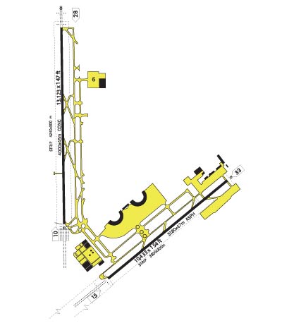
| Lat: S 2248.6 Long: W 04315.0 Elev: 28 Var: +22 Longest Runway: 13123 | ||
| Dept. ATIS: 127.6 Arr. ATIS: 127.6 Ground: 121.65 Tower: 118.0 | ||
| |||||
| |||||
|
 |  |
| ||||
NOTICE: Information listed below may not be current.
| ||||||||||
| ||||||||||
| ||||||||||
| Rotating Beacon: YES | ||||||||||
| ||||||||||
| ||||||||||
| COMMUNICATION INFORMATION APPROACH CONTROL - RIO APP 119.35 AUTOMATIC TERMINAL INFORMATION SERVICE - ATIS 127.6 CLEARANCE DELIVERY - CLNC DEL (Opr 0900-0200Z.) 121.0 GROUND CONTROL - GND 121.65 OPERATIONS - OPS 122.5 TOWER - TWR 118.0 118.2 | ||||||||||
| OPERATING HOURS CLEARANCE DELIVERY - Opr 0900-0200Z. | ||||||||||
| INSTRUMENT APPROACHES VORDME RW28 DESC(D2) DESCENT C4 ILS RW10 DESCENT C2 ILS RW15 DESCENT C3 ILS RW15 DESCENT C7 ILS RW28 DESCENT D1 NDB RW15 DESCENT D1 VOR RW15 | ||||||||||
| APPROACH MINIMUMS VORDME RW28 DESC(D2) CIRCL Approach Minimums Category A: 660' MSL and 2400 METERS Category B: 660' MSL and 2400 METERS Category C: 720' MSL and 3200 METERS Category D: 900' MSL and 4400 METERS Category E: NA VORDME RW28 DESC(D2) S- 28 Approach Minimums Category A: 660' MSL and 2400 METERS Category B: 660' MSL and 2400 METERS Category C: 660' MSL and 2800 METERS Category D: 660' MSL and 3200 METERS Category E: NA DESCENT C4 ILS RW10 CIRCL Approach Minimums Category A: 720' MSL and 1600 METERS Category B: 820' MSL and 2000 METERS Category C: 1000' MSL and 4800 METERS Category D: 1000' MSL and 4800 METERS Category E: NA DESCENT C4 ILS RW10 S-ILS Approach Minimums Category A: 218' MSL and 80000 RVR Category B: 218' MSL and 80000 RVR Category C: 218' MSL and 80000 RVR Category D: 218' MSL and 80000 RVR Category E: NA DESCENT C4 ILS RW10 S-LOC Approach Minimums Category A: 500' MSL and 800 METERS Category B: 500' MSL and 800 METERS Category C: 500' MSL and 1200 METERS Category D: 500' MSL and 1600 METERS Category E: NA DESCENT C2 ILS RW15 CIRCL Approach Minimums Category A: 720' MSL and 1600 METERS Category B: 820' MSL and 2000 METERS Category C: 1000' MSL and 4800 METERS Category D: 1000' MSL and 4800 METERS Category E: NA DESCENT C2 ILS RW15 S-ILS Approach Minimums Category A: 221' MSL and 800 METERS Category B: 221' MSL and 800 METERS Category C: 221' MSL and 800 METERS Category D: 221' MSL and 800 METERS Category E: NA DESCENT C2 ILS RW15 S-LOC Approach Minimums Category A: 660' MSL and 800 METERS Category B: 660' MSL and 800 METERS Category C: 660' MSL and 2000 METERS Category D: 660' MSL and 2400 METERS Category E: NA DESCENT C3 ILS RW15 CIRCL Approach Minimums Category A: 720' MSL and 1600 METERS Category B: 820' MSL and 2000 METERS Category C: 1000' MSL and 4800 METERS Category D: 1000' MSL and 4800 METERS Category E: NA DESCENT C3 ILS RW15 S-ILS Approach Minimums Category A: 221' MSL and 800 METERS Category B: 221' MSL and 800 METERS Category C: 221' MSL and 800 METERS Category D: 221' MSL and 800 METERS Category E: NA DESCENT C3 ILS RW15 S-LOC Approach Minimums Category A: 660' MSL and 800 METERS Category B: 660' MSL and 800 METERS Category C: 660' MSL and 2000 METERS Category D: 660' MSL and 2400 METERS Category E: NA DESCENT C7 ILS RW28 CIRCL Approach Minimums Category A: 560' MSL and 1600 METERS Category B: 560' MSL and 1600 METERS Category C: 720' MSL and 3200 METERS Category D: 920' MSL and 4800 METERS Category E: NA DESCENT C7 ILS RW28 S-ILS Approach Minimums Category A: 240' MSL and 1200 METERS Category B: 240' MSL and 1200 METERS Category C: 240' MSL and 1200 METERS Category D: 240' MSL and 1200 METERS Category E: NA DESCENT C7 ILS RW28 S-LOC Approach Minimums Category A: 540' MSL and 1600 METERS Category B: 540' MSL and 1600 METERS Category C: 540' MSL and 2400 METERS Category D: 540' MSL and 2800 METERS Category E: NA DESCENT D1 NDB RW15 CIRCL Approach Minimums Category A: 720' MSL and 1600 METERS Category B: 820' MSL and 2000 METERS Category C: 1000' MSL and 4800 METERS Category D: 1000' MSL and 4800 METERS Category E: NA DESCENT D1 NDB RW15 S-15* Approach Minimums Category A: 660' MSL and 1200 METERS Category B: 660' MSL and 1200 METERS Category C: 660' MSL and 2000 METERS Category D: 660' MSL and 2800 METERS Category E: NA DESCENT D1 VOR RW15 CIRCL Approach Minimums Category A: 720' MSL and 1600 METERS Category B: 820' MSL and 2000 METERS Category C: 1000' MSL and 4800 METERS Category D: 1000' MSL and 4800 METERS Category E: NA DESCENT D1 VOR RW15 S-15* Approach Minimums Category A: 660' MSL and 800 METERS Category B: 660' MSL and 800 METERS Category C: 660' MSL and 2000 METERS Category D: 660' MSL and 2400 METERS Category E: NA | ||||||||||
| APPROACH REMARKS VORDME RW28 DESC(D2) - CIRCLING* - *Circling not authorized S of Rwy 10-28. DESCENT C4 ILS RW10 - CIRCLING - CIRCLING NOT AUTHORIZED S OF RWY 10-28. DESCENT C4 ILS RW10 - S-ILS 10 - S-ILS ALL CAT VIS INCREASED 400M FOR INO P ALS. DESCENT C4 ILS RW10 - S-LOC 10 - S-LOC ALL CAT VIS INCREASED 800M FOR INO P ALS. DESCENT C2 ILS RW15 - CIRCLING**** - ****Circling NA NE of Rwy 15-33, max 170 KIAS. DESCENT C2 ILS RW15 - S-ILS 15** - **When ALS inop, increase vis all CAT 4 00m. DESCENT C2 ILS RW15 - S-LOC 15*** - ***When ALS inop, increase vis 800m. DESCENT C3 ILS RW15 - CIRCLING**** - ****CIRCLING not authorized NE OF RWY 15 -33, 170 KIAS maximum. DESCENT C3 ILS RW15 - S-ILS 15** - **All CAT S-ILS visibility increased 400 m for inoperative ALS. DESCENT C3 ILS RW15 - S-LOC 15*** - ***All CAT S-LOC visibility increased 80 0m for inoperative ALS. DESCENT C7 ILS RW28 - CIRCLING* - *Circling not authorized S of Rwy 10-28. DESCENT D1 NDB RW15 - CIRCLING*** - ***Circling Not Authorized NE of Rwy 15- 33, max 170 KIAS. DESCENT D1 NDB RW15 - S-15** - **When ALS inop, increased vis Cat AB to 1600M, Cat C to 2800M, Cat D to 3200M. DESCENT D1 VOR RW15 - CIRCLING*** - ***CIRCLING N/A NE OF RWY 15-33, max 170 KIAS. DESCENT D1 VOR RW15 - S-15** - **When ALS inop, increase vis 800m. | ||||||||||
| AIRPORT NAVAIDS CAX - CAXIAS (VOR-DME) - Bearing: 133° Distance: 5.3 nm CAX - CAXIAS (NDB) - Bearing: 118° Distance: 5.9 nm IT - MERITI (NDB) - Bearing: 101° Distance: 6.7 nm PCX - PORTO (VOR-DME) - Bearing: 276° Distance: 22.1 nm YLA - ILHA (NDB) - Bearing: 253° Distance: 4.4 nm | ||||||||||
| STANDARD INSTRUMENT DEPARTURE INFORMATION (SIDs) MARIC1 MARICA1 MARIC4 MARCIA4 PORTO3 | ||||||||||
| TERMINAL AREA REMARKS MARIC1 MARICA1 NOTE: When SBR 16 active: departures with BOTOM or MOTOB transition will be sus pended. NOTE: When SBR 314 or 333 active: BOTOM transition will read MRC R-260 until MRC 50 DME, then resume course. DEPARTURE ROUTE DESCRIPTION: TAKE-OFF RWY 33: Intcp CAX VOR/DME R-138 (325 Brg to CAX NDB) until 2.6 DME from CAX, then turn right to intcp CAX VOR/DME R-095 outbound until crossing MRC VOR/DME R-335 (PCX VOR/DME 16.3 DME), then turn righ t to intcp MRC R-343 inbound, then turn right to intcp PCX R-245 outbound for BO TOM or MOTOB transition, or turn right to intcp PCX R-235 outbound for ISOM tran sition. TAKE-OFF RWY 10: Fly rwy hdg. After passing 500 turn left hdg 063 un til crossing MRC R-335 (PCX 16.3 DME), then turn right to intcp MRC R-343 inboun d, then turn right to intcp PCX R-245 outbound for BOTOM or MOTOB transition, or turn right to intcp PCX R-235 outbound for ISOM transition. BOTOM TRANSITION: at DACIR, turn right and proceed outbound MRC VOR/DME R-275 direct BOTOM. MOTOB TRANSITION: at NAROB, turn right and proceed outbound ADA VOR/DME R-274 direct MOTOB. MARIC4 MARCIA4 DEPARTURE ROUTE DESCRIPTION: TAKEOFF RUNWAY 28: Fly heading 275 until crossing CAX VOR/DME R-187, then turn left to intercept CAX R-211, cross CAX R-211/5 DME at or above 2000, cross CAX R-211/16 DME at or above 5000, then turn left to in tercept MRC VOR/DME R-275 to MRC, cross MRC at or below FL70, then... TAKEOFF RU NWAY 33: Intercept CAX R-138 (325 bearing to CAX NDB) until 2.6 DME from CAX, then turn left to intercept CAX R-211outbound, cross CAX R-211/ 5 DME at or abov e 2000, cross CAX R-211/16 DME at or above 5000, then turn left to intercept MRC R-275 to MRC, cross MRC at or below FL70, then... AGUA TRANSITION: Via MRC R-1 23 to AGUA, then turn left to intercept 053 bearing to ADA VOR/DME NDB. ABSAL T RANSITION: Via MRC R-028 to PCX VOR/DME, cross PCX at or above FL90, then via PCX R-351 to ABSAL. ASGAT TRANSITION: Via MRC R-028 to PCX, cross PCX at or a bove FL90, then via PCX R-345 to ASGAT. AWAKE TRANSITION: Via MRC R-028 to PCX , cross PCX at orabove fl90, then via PCX R-046 to AWAKE. DONA TRANSITION: Vi a MRC R-028 to PCX, cross PCX at or above FL90, then via PCX R-034 to DONA. ESO RA TRANSITION: Via MRC R-028 to PCX, cross PCX at or above FL90, then via PCXR -001 to ESORA. FIGOS TRANSITION: Via MRC R-028 to PCX, cross PCX at or above FL90, then via PCX R-066 to FIGOS. HAMIL TRANSITION: Via MRC R-028 to PCX, cros s PCX at or above FL90, then via PCX R-053 to HAMIL KNOLL TRANSITION: Via MR C R-028 to PCX, cross PCX at or above FL90, then via PCX R-002 to KNOLL. RIFO T RANSITION: Via MRC R-138 to RIFO, then turn left on 101 bearing to EKALO. PORTO3 Any acft unable to perform minimum climb rate, advise clearance before engine st art. DEPARTURE ROUTE DESCRIPTION: TAKE-OFF RWY 10: Fly runway heading until reaching 500, then turn left heading 063 to intercept PCX R-290 inbound, cross PCX 5 DM E at or above 3000 across PCX at or above 4500 then.... TAKE-OFF RWY 33: Inter cept CAX VOR/DME R-138(325 bearing to CAX NDB) until 2.6 DME from CAX, then tu rn right heading 095 to intecept PCX R-290 inbound, cross PCX 5 DME at or above 3000, cross PCX at or above 4500, then.... ASGAT TRANSITION: Via PCX R-345 to A SGAT. Cross 15 DME at or above FL 100, then via ATC instructions. DONA TRANSIT ION: Via PCX R-034 to DONA. Cross 9 DME at or above FL100, then via ATC instruct ions. ESORA TRANSITION: Via PCX R-001 to ESORA . Cross 15 DME at or above FL 10 0, then via ATC instructions. FIGOS TRANSITION: Via PCX R-066 to FIGOS. Cross 9 DME at or above FL 100, then via ATC instructions. ABSAL TRANSITION: Via PCX R-351 to ABSAL . Cross 15 DME at or above FL 100, then via ATC instructions. A WAKE TRANSITION: Via PCX R-046 to AWAKE. Cross 9 DME at or above FL 100, then via ATC instructions. KNOLL TRANSITION: Via PCX R-002 to KNOLL. Cross 15 DM E at or above FL 100, then via ATC instructions. HAMIL TRANSITION: Via PCX R-0 53 to HAMIL. Cross 9 DME at or above FL 100, then via ATC instructions. VORDME RW28 DESC(D2) MISSED APPROACH: Climb to 5000 on CAX R-115, turn left at 2 DME to intercept CAX R-211. DESCENT C4 ILS RW10 Descent based on 220 KIAS, 2000 fpm. Max holding 230 KIAS. Max holding alt FL140. Glide Slope Angle 3.00 Deg/TCH 61 . MISSED APPROACH: Climb to 2000 on 096 hdg, then intercept MRC VOR/DME R-335 inb d to MRC. After intcp MRC-335, climb to 5000. Hold at MRC rquest detailed inst r from ATC. DESCENT C2 ILS RW15 Tlv as assigned. Descent based on 220 KIAS, 2300 fpm. Reduce speed to final app roach speed at or above 2000 at CAX 3.6 DME/IGL 9.5 DME. Max holding 230 KIAS. Max holding alt FL140. Glide Slope Angle 3.00 Deg/TCH 61 . MISSED APPROACH: Fly runway heading climbing to 5000, intcp 113 brg from IT NDB and proceed outbound, then intcp MRC VOR/DME R-360. Hold on MRC R-360, request detailed holding instructions from ATC. *If IT NDB inop, intercept 100 bearin g from AFS NDB, rest remains the same. DESCENT C3 ILS RW15 CAUTION: Missed approach minimum climb rate to 2500. Max holding 170 KIAS. Glide Slope Angle 3.00 Deg/TCH 61 . MISSED APPROACH: Fly rwy hdg climbing to 5000, intcp 113 brg from IT NDB and pr oceed outbound, then intcp MRC VOR/DME R-360. Hold on MRC R-360, request detail ed instructions from ATC. *If IT NDB inop, intercept 100 bearing from AFS NDB, rest remains the same. DESCENT C7 ILS RW28 Glide Slope Angle 2.94 Deg/TCH 51 . MISSED APPROACH: Climb to 5000, cross CAX R-187, then turn left, intercept CAX R -211. DESCENT D1 NDB RW15 DME REQUIRED. CAUTION: Missed approach minimum climb rate to 2500. *If IT NDB inop, intercept 100 bearing from AFS NDB, rest remains the same. Max holding 170 KIAS. MISSED APPROACH: Fly rwy hdg climbing to 5000, intercept 113 brg from IT NDB an d proceed outbound, then intercept MRC VOR/DME R-360. Hold on MRC R-360, reques t detailed instructions from ATC. DESCENT D1 VOR RW15 Maximum holding 170 KIAS. PT Not Authorized. MISSED APPROACH: Fly rwy hdg climbing to 5000, intercept 113 brg from IT NDB an d proceed outbound, then intercept MRC VOR/DME R-360. Hold on MRC R-360, reques t detailed instructions from ATC. | ||||||||||
| CLIMB/DECENT RATE INFORMATION RWY 28 (MARIC4 MARCIA4) REQUIRES A CLIMB RATE (AT 60 KNOTS) OF 360'/min TO 2000' (Minimum Climb Rate to 2000.) RWY 33 (MARIC4 MARCIA4) REQUIRES A CLIMB RATE (AT 60 KNOTS) OF 310'/min TO 2000' (Minimum Climb Rate to 2000.) RWY 10 (PORTO3) REQUIRES A CLIMB RATE (AT 60 KNOTS) OF 330'/min TO 9000' (Minimum Climb Rate to FL90.) RWY 33 (PORTO3) REQUIRES A CLIMB RATE (AT 60 KNOTS) OF 330'/min TO 90000' RWY 15 (DESCENT C2 ILS RW15) REQUIRES A CLIMB RATE (AT 60 KNOTS) OF 310'/min TO 2500' (CAUTION: Missed approach minimum climb rate to 2500.) RWY 15 (DESCENT C3 ILS RW15) REQUIRES A CLIMB RATE (AT 60 KNOTS) OF 310'/min TO 2500' (Missed approach minimum climb rate to 2500.) RWY 15 (DESCENT D1 NDB RW15) REQUIRES A CLIMB RATE (AT 60 KNOTS) OF 310'/min TO 2500' (missed approach minimum climb rate to 2500) RWY 15 (DESCENT D1 VOR RW15) REQUIRES A CLIMB RATE (AT 60 KNOTS) OF 310'/min TO 5000' (CAUTION: Missed Approach Minimum Climb Rate) | ||||||||||
| AIRPORT REMARKS IFR TAKE-OFF MINIMUMS AND DEPARTURE PROCEDURES Diverse departures not authorized. | ||||||||||
Thanks for using FltPlan.com
all rights reserved © 1999-2024 by Flight Plan LLC