| ARDMORE MUNI ARDMORE OK |
| |
| Lat: N 3418.2 Long: W 09701.2 Elev: 777 Var: -06 Longest Runway: 9002 | ||
| Dept. ATIS: 125.6 Arr. ATIS: 125.6 Ground: 121.8 Tower: 118.5 | ||
| ||||||||||||||||||||||||||||||||||||||||||||||||||||||||||||||||||||
| ||||||||||||||||||||||||||||||||||||||||||||||||||||||||||||||||||||
| ||||||||||||||||||||||||||||||||||||||||||||||||||||||||||||||||||||
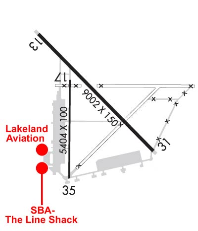
| Rwy | Rwy | |||||||
| 9002x150 | 9002' | 9002x150 | 9002' | 108.90 - 309° | ||||
| 5404x100 | 5404' | 5404x100 | 5007' | |||||
| Runway ID | Single Wheel | Double Wheel | Double Tandem Wheel | Dual Double Wheel |
| 13/31 | N/A | N/A | N/A | N/A |
| 17/35 | 36,000 | N/A | N/A | N/A |
| These numbers are Advisory and are not limits. The Airport Manager should have more accurate Weight Limits | ||||
 Airport Diagram might not be current. | |
| Facility Name: | ARDMORE MUNI |
| City Name: | ARDMORE |
| County: | CARTER |
| State abbrev: | OK |
| State Name: | OKLAHOMA |
| Ownership: | PUBLICLY OWNED |
| Use: | OPEN TO THE PUBLIC |
| Owner's Name: | CITY OF ARDMORE; ARPT OPERD BY ARDMORE DVLPMT AUTH 580-389-5238. |
| Address: | 23 S. WASHINGTON |
| ARDMORE, OK 73401 | |
| Owner's Phone: | 580-226-2100 |
| Manager's Name: | DAN LUTTRELL |
| Address: | 620 GENERAL DR., SUITE 1 |
| ARDMORE, OK 73401 | |
| Phone: | 580-389-5238 |
| FAA Region: | SOUTHWEST |
| FAA Field Office: | AOK |

| Date | Sunrise | Sunset |
|---|---|---|
| 04/16/24 Tuesday | 6:55 | 20:01 |
| 04/17/24 Wednesday | 6:53 | 20:02 |
| 04/18/24 Thursday | 6:52 | 20:03 |
| 04/19/24 Friday | 6:51 | 20:04 |
| 04/20/24 Saturday | 6:50 | 20:04 |
| 04/21/24 Sunday | 6:49 | 20:05 |
| 04/22/24 Monday | 6:47 | 20:06 |
| 04/23/24 Tuesday | 6:46 | 20:07 |
| 04/24/24 Wednesday | 6:45 | 20:08 |
| 04/25/24 Thursday | 6:44 | 20:08 |
| 04/26/24 Friday | 6:43 | 20:09 |
| 04/27/24 Saturday | 6:42 | 20:10 |
| 04/28/24 Sunday | 6:41 | 20:11 |
| 04/29/24 Monday | 6:40 | 20:11 |
| Airport Attendance Schedule | MON-FRI 0700-2300, SAT-SUN 0700-1700 |
| Airport Status | OPERATIONAL (This Status can change at any time - please check NOTAMS) |
| Airport Lighting Schedule | WHEN ATCT CLSD ACTVT MALSR RWY 31; HIRL RWY 13/31 - CTAF; MIRL RWY 17/35 ON DUSK-DAWN. |
| Airport Storage Available | Tie Downs, Hanger |
| Extra Services Available | Flight Instruction, Aircraft Rental |
| Wind Indicator | YES - (unlit) |
| Control Tower | YES |
| CTAF Frequency | 118.500 |
| Unicom Frequency | 122.950 |
| Rotating Beacon Color | WG |
| Segmented Circle | NO |
| Landing Fee | NO |
| Airport Inspected | STATE - performed by STATE AERONAUTICAL PERSONNEL |
| Inspection Date | 04/13/2023 |
| Type of Fuel Available | Grade 100LL, JET A (freeze point -40C) |
| Airframe Repair Service | MAJOR |
| Power Plant Repair Service | MAJOR |
| Latitude | N3418.2 |
| Longitude | W09701.2 (ESTIMATED) |
| Arpt Elevation | 776ft (SURVEYED) |
| Magnetic Variation | 06E |
| 10 miles NE | of ARDMORE |
| Traffic Pattern Altitude | |
| Sectional Chart | DALLAS-FT WORTH |
| Operations (Reported) | Yearly | Avg. Daily |
|---|---|---|
| General Aviation Transient | 15386 | 42 |
| General Aviation Local | 5793 | 16 |
| Air Taxi | 260 | 1 |
| Commerical | 0 | 0 |
| Commuter | 0 | 0 |
| Military | 4731 | 13 |
| Aircraft based on Field | |
|---|---|
| General Aviation Singles | 10 |
| General Aviation Multi | 5 |
| Jet Aircraft | 1 |
| General Aviation Helicopters | 0 |
| Military Aircraft | 0 |
| Gliders | 0 |
| Ultralights | 0 |
| FSS on field | NO |
| FSS tie-in | MC ALESTER |
| FSS Phone | 1-800-WX-BRIEF |
| Who issues Notams | ADM |
| Notam D service at airport | YES |
| ARTCC Name | FORT WORTH |
| Airport Certification | |
| Aircraft Rescue & Firefighting Index | None |
| Airport of Entry | No |
| Custom Landing Rights | No |
| Joint Civil/Military | No |
| Military Landing rights | YES |
| NATIONAL PLAN OF INTEGRATED AIRPORT SYSTEMS (NPIAS) |
| GRANT AGREEMENTS UNDER FAAP/ADAP/AIP |
| SURPLUS PROPERTY AGREEMENT UNDER PUBLIC LAW 289 |
| ASSURANCES PURSUANT TO TITLE VI, CIVIL RIGHTS ACT OF 1964 |
| FOR CD IF UNA TO CTC ON FSS FREQ, CTC FORT WORTH ARTCC AT 817-858-7584. |
Airport Communications & Frequencies:
| |||||||||||||||||||||
| Runway: 13 | Runway: 31 | ||
| Mag heading: | 129° | Mag heading: | 309° |
| Rwy Slope: | -.53% Down | Rwy Slope: | .53% Up |
| Approach: | Approach: | ILS | |
| Pattern: | Left Traffic | Pattern: | Left Traffic |
| Markings: | PRECISION INSTRUMENT | Markings: | PRECISION INSTRUMENT |
| Marking Condition: | FAIR | Marking Condition: | FAIR |
| Arresting Dev: | Arresting Dev: | ||
| Lat & Long: | N3418.9 W09701.8 | Lat. & Long.: | N3417.8 W09700.5 |
| Elev: | 776.7 ft. MSL | Elev: | 728.9 ft. MSL |
| TCH: | 57 ft. AGL | TCH: | 49 ft. AGL |
| Visual Glide Path: | 3.00 degrees | Visual Glide Path: | 3.00 degrees |
| Displaced Threshold: | No | Displaced Threshold: | No |
| Touchdown Zone: | YES | Touchdown Zone: | YES |
| Touchdown Elev.: | 776.7 feet | Touchdown Elev.: | 732.9 feet |
| Visual Glide Slope: | 4-Light PAPI on LEFT side of Runway | Visual Glide Slope: | 4-BOX VASI ON LEFT SIDE OF RUNWAY |
| RVR Equipment: | RVR Equipment: | ||
| RVV Equipment: | NO | RVV Equipment: | NO |
| Approach Lights: | Approach Lights: | MALSR - 1,400 foot medium intensity approach lighting system with runway alignment indicator lights | |
| REIL: | NO | REIL: | NO |
| Centerline Lights: | NO | Centerline Lights: | NO |
| Touchdown lights: | NO | Touchdown lights: | NO |
| Runway Category: | Runway with a Non-precision Approach having visibility minimums greater than 3/4 mile | Runway Category: | Precision Instrument Runway |
| Declared Distances: | Declared Distances: | ||
| Obstructions: | TREES | Obstructions: | TREES |
| Marked: | NOT Marked/Lighted | Marked: | NOT Marked/Lighted |
| Clearance slope: | 25:1 | Clearance slope: | 27:1 |
| Obstruction height: | 72 feet AGL | Obstruction height: | 68 feet AGL |
| Dist. from runway: | 2000 feet | Dist. from runway: | 2075 feet |
| Centerline offset: | 660 left of centerline | Centerline offset: | 366 feet left of centerline |
| Comments: | Comments: |
| Runway: 17 | Runway: 35 | ||
| Mag heading: | 174° | Mag heading: | 354° |
| Rwy Slope: | -.49% Down | Rwy Slope: | .49% Up |
| Approach: | Approach: | ||
| Pattern: | Left Traffic | Pattern: | Left Traffic |
| Markings: | BASIC | Markings: | BASIC |
| Marking Condition: | GOOD | Marking Condition: | GOOD |
| Arresting Dev: | Arresting Dev: | ||
| Lat & Long: | N3418.5 W09701.4 | Lat. & Long.: | N3417.6 W09701.4 |
| Elev: | 751.1 ft. MSL | Elev: | 724.7 ft. MSL |
| TCH: | TCH: | ||
| Visual Glide Path: | Visual Glide Path: | ||
| Displaced Threshold: | No | Displaced Threshold: | 397 feet |
| Touchdown Zone: | YES | Touchdown Zone: | YES |
| Touchdown Elev.: | 751.1 feet | Touchdown Elev.: | 725.4 feet |
| Visual Glide Slope: | Visual Glide Slope: | ||
| RVR Equipment: | RVR Equipment: | ||
| RVV Equipment: | NO | RVV Equipment: | NO |
| Approach Lights: | Approach Lights: | ||
| REIL: | NO | REIL: | NO |
| Centerline Lights: | NO | Centerline Lights: | NO |
| Touchdown lights: | NO | Touchdown lights: | NO |
| Runway Category: | Runway with a Visual Approach | Runway Category: | Runway with a Visual Approach |
| Declared Distances: | TORA:5007' TODA:5007' ASDA:5007' LDA:5007' | Declared Distances: | TORA:5404' TODA:5404' ASDA:5404' LDA:5007' |
Thanks for using FltPlan.com
all rights reserved © 1999-2024 by Flight Plan LLC