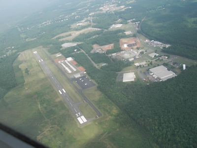
| LOUISA COUNTY/FREEMAN FIELD LOUISA VA |
| |
| Lat: N 3800.6 Long: W 07758.2 Elev: 494 Var: +10 Longest Runway: 4300 | ||
| AWOS: 119.47 CTAF: 122.97 | ||
| |||||||||||||||||||||||||||||||||||||||||||||||||||||||||||||
| |||||||||||||||||||||||||||||||||||||||||||||||||||||||||||||
| |||||||||||||||||||||||||||||||||||||||||||||||||||||||||||||
| |||||||||||||||||||||||||||||||||||||||||||||||||||||||||||||
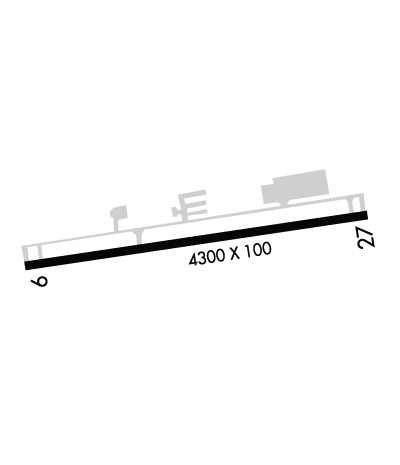
| Rwy | Rwy | |||||||
| 4300x100 | 4300' | 4300x100 | 4300' | 108.55 - 272° | ||||
| Runway ID | Single Wheel | Double Wheel | Double Tandem Wheel | Dual Double Wheel |
| 09/27 | 12,500 | N/A | N/A | N/A |
| These numbers are Advisory and are not limits. The Airport Manager should have more accurate Weight Limits | ||||
 Airport Diagram might not be current. | |
| Facility Name: | LOUISA COUNTY/FREEMAN FLD |
| City Name: | LOUISA |
| County: | LOUISA |
| State abbrev: | VA |
| State Name: | VIRGINIA |
| Ownership: | PUBLICLY OWNED |
| Use: | OPEN TO THE PUBLIC |
| Owner's Name: | IND DEV AUTH OF LOUISA CO. |
| Address: | PO BOX 27 |
| LOUISA, VA 23093 | |
| Owner's Phone: | 540-967-0050 |
| Manager's Name: | EDWARD JARVIS |
| Address: | 335 INDUSTRIAL DR, P.O. BOX 27 |
| LOUISA, VA 23093 | |
| Phone: | 540-967-0050; EJARVIS@LOUISA.ORG |
| FAA Region: | EASTERN |
| FAA Field Office: | DCA |
| Date | Sunrise | Sunset |
|---|---|---|
| 09/24/21 Friday | 7:01 | 19:06 |
| 09/25/21 Saturday | 7:02 | 19:05 |
| 09/26/21 Sunday | 7:03 | 19:03 |
| 09/27/21 Monday | 7:04 | 19:01 |
| 09/28/21 Tuesday | 7:05 | 19:00 |
| 09/29/21 Wednesday | 7:06 | 18:58 |
| 09/30/21 Thursday | 7:06 | 18:57 |
| 10/01/21 Friday | 7:07 | 18:55 |
| 10/02/21 Saturday | 7:08 | 18:54 |
| 10/03/21 Sunday | 7:09 | 18:52 |
| 10/04/21 Monday | 7:10 | 18:51 |
| 10/05/21 Tuesday | 7:11 | 18:49 |
| 10/06/21 Wednesday | 7:12 | 18:48 |
| 10/07/21 Thursday | 7:13 | 18:46 |
| Airport Attendance Schedule | MON-SAT 0830-1700, SUN&HOL 1000-1700 |
| Airport Status | OPERATIONAL (This Status can change at any time - please check NOTAMS) |
| Airport Lighting Schedule | ACTVT REIL RWY 09/27; PAPI RWY 09 & 27; MIRL RWY 09/27 - CTAF. |
| Airport Storage Available | Tie Downs, Hanger |
| Extra Services Available | Flight Instruction |
| Wind Indicator | YES - (lighted) |
| Control Tower | NO |
| CTAF Frequency | 122.975 |
| Unicom Frequency | 122.975 |
| Rotating Beacon Color | CLEAR-GREEN (Light Land Airport) |
| Segmented Circle | YES |
| Landing Fee |
| Airport Inspected | STATE - performed by STATE AERONAUTICAL PERSONNEL |
| Inspection Date | 05/30/2019 |
| Type of Fuel Available | Grade 100LL, JET A (freeze point -40C) |
| Airframe Repair Service | MAJOR |
| Power Plant Repair Service | MAJOR |
| Latitude | N3800.6 |
| Longitude | W07758.2 (ESTIMATED) |
| Arpt Elevation | 493ft (SURVEYED) |
| Magnetic Variation | 10W |
| 2 miles SE | of LOUISA |
| Traffic Pattern Altitude | |
| Sectional Chart | WASHINGTON |
| Operations (Reported) | Yearly | Avg. Daily |
|---|---|---|
| General Aviation Transient | 9883 | 27 |
| General Aviation Local | 19768 | 54 |
| Air Taxi | 741 | 2 |
| Commerical | 0 | 0 |
| Commuter | 0 | 0 |
| Military | 494 | 1 |
| Aircraft based on Field | |
|---|---|
| General Aviation Singles | 45 |
| General Aviation Multi | 5 |
| Jet Aircraft | 1 |
| General Aviation Helicopters | 0 |
| Military Aircraft | 0 |
| Gliders | 0 |
| Ultralights | 0 |
| FSS on field | NO |
| FSS tie-in | LEESBURG |
| FSS Phone | 1-800-WX-BRIEF |
| Who issues Notams | LKU |
| Notam D service at airport | YES |
| ARTCC Name | WASHINGTON |
| Airport Certification | |
| Aircraft Rescue & Firefighting Index | None |
| Airport of Entry | No |
| Custom Landing Rights | No |
| Joint Civil/Military | No |
| Military Landing rights | No |
| NATIONAL PLAN OF INTEGRATED AIRPORT SYSTEMS (NPIAS) |
| GRANT AGREEMENTS UNDER FAAP/ADAP/AIP |
| ASSURANCES PURSUANT TO TITLE VI, CIVIL RIGHTS ACT OF 1964 |
| BCN LOCATED ON WATER TWR; NORTH SIDE APCH RY 27. |
| DEER & BIRDS ON & INVOF ARPT. |
| 3 FT PVC GAS LINE MARKER LCTD APRX 26 FT FM RY 09 THLD, 54 FT LEFT OF CNTRLN. |
| FOR CD CTC POTOMAC APCH AT 866-640-4124. |
Airport Communications & Frequencies:
| ||||||||||||||||||
| Runway: 09 | Runway: 27 | ||
| Mag heading: | 92° | Mag heading: | 272° |
| Rwy Slope: | .56% Up | Rwy Slope: | -.56% Down |
| Approach: | Approach: | LOC/DME | |
| Pattern: | Right Traffic | Pattern: | Left Traffic |
| Markings: | NONPRECISION INSTRUMENT | Markings: | NONPRECISION INSTRUMENT |
| Marking Condition: | GOOD | Marking Condition: | GOOD |
| Arresting Dev: | Arresting Dev: | ||
| Lat & Long: | N3800.5 W07758.7 | Lat. & Long.: | N3800.6 W07757.8 |
| Elev: | 469.4 ft. MSL | Elev: | 493.5 ft. MSL |
| TCH: | 40 ft. AGL | TCH: | 40 ft. AGL |
| Visual Glide Path: | 3.00 degrees | Visual Glide Path: | 3.00 degrees |
| Displaced Threshold: | No | Displaced Threshold: | No |
| Touchdown Zone: | YES | Touchdown Zone: | YES |
| Touchdown Elev.: | 488.5 feet | Touchdown Elev.: | 493.7 feet |
| Visual Glide Slope: | 2-Light PAPI on LEFT side of Runway | Visual Glide Slope: | 2-Light PAPI on LEFT side of Runway |
| RVR Equipment: | RVR Equipment: | ||
| RVV Equipment: | NO | RVV Equipment: | NO |
| Approach Lights: | Approach Lights: | ||
| REIL: | YES | REIL: | YES |
| Centerline Lights: | NO | Centerline Lights: | NO |
| Touchdown lights: | NO | Touchdown lights: | NO |
| Runway Category: | Runway with a Non-precision Approach | Runway Category: | Runway with a Non-precision Approach |
| Declared Distances: | Declared Distances: | ||
| Obstructions: | TREES | Obstructions: | TREES |
| Marked: | NOT Marked/Lighted | Marked: | NOT Marked/Lighted |
| Clearance slope: | 11:1 | Clearance slope: | 45:1 |
| Obstruction height: | 39 feet AGL | Obstruction height: | 12 feet AGL |
| Dist. from runway: | 638 feet | Dist. from runway: | 741 feet |
| Centerline offset: | 292 right of centerline | Centerline offset: | 312 feet left of centerline |
| Comments: | Comments: | BRUSH LCTD APPROX 39 FT FM THLD, 132 FT RIGHT OF CNTRLN. |
Thanks for using FltPlan.com
all rights reserved © 1999-2021 by Flight Plan LLC