
| HEREFORD MUNI HEREFORD TX |
| |
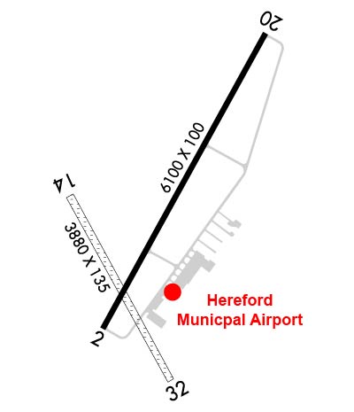
| Lat: N 3451.6 Long: W 10219.6 Elev: 3788 Var: -09 Longest Runway: 6100 | ||
| AWOS: 118.05 CTAF: 122.8 | ||
| ||||||||||||||||||||||||||||||||||||||||||||||||||||||||||||||||||||
| ||||||||||||||||||||||||||||||||||||||||||||||||||||||||||||||||||||
| ||||||||||||||||||||||||||||||||||||||||||||||||||||||||||||||||||||
| Rwy | Rwy | |||||||
| 6100x100 | 6100' | 6100x100 | 6100' | |||||
| 3807x135 | 3807' | 3807x135 | 3807' | |||||
| Runway ID | Single Wheel | Double Wheel | Double Tandem Wheel | Dual Double Wheel |
| 02/20 | N/A | N/A | N/A | N/A |
| 14/32 | N/A | N/A | N/A | N/A |
| These numbers are Advisory and are not limits. The Airport Manager should have more accurate Weight Limits | ||||
 Airport Diagram might not be current. | |
| Facility Name: | HEREFORD MUNI |
| City Name: | HEREFORD |
| County: | DEAF SMITH |
| State abbrev: | TX |
| State Name: | TEXAS |
| Ownership: | PUBLICLY OWNED |
| Use: | OPEN TO THE PUBLIC |
| Owner's Name: | CITY OF HEREFORD |
| Address: | BOX 2277 |
| HEREFORD, TX 79045 | |
| Owner's Phone: | 806-363-7100 |
| Manager's Name: | CAYDEN FINCH |
| Address: | 4175 US HWY 60 |
| HEREFORD, TX 79045 | |
| Phone: | 806-344-7710 |
| FAA Region: | SOUTHWEST |
| FAA Field Office: | TEX |
| Date | Sunrise | Sunset |
|---|---|---|
| 08/04/25 Monday | 7:01 | 20:49 |
| 08/05/25 Tuesday | 7:02 | 20:48 |
| 08/06/25 Wednesday | 7:03 | 20:47 |
| 08/07/25 Thursday | 7:03 | 20:46 |
| 08/08/25 Friday | 7:04 | 20:45 |
| 08/09/25 Saturday | 7:05 | 20:44 |
| 08/10/25 Sunday | 7:06 | 20:43 |
| 08/11/25 Monday | 7:06 | 20:42 |
| 08/12/25 Tuesday | 7:07 | 20:41 |
| 08/13/25 Wednesday | 7:08 | 20:40 |
| 08/14/25 Thursday | 7:09 | 20:39 |
| 08/15/25 Friday | 7:09 | 20:38 |
| 08/16/25 Saturday | 7:10 | 20:36 |
| 08/17/25 Sunday | 7:11 | 20:35 |
| Airport Attendance Schedule | 7 Days A Week 0800-1700 |
| Airport Status | OPERATIONAL (This Status can change at any time - please check NOTAMS) |
| Airport Lighting Schedule | MIRL RWY 02/20 PRESET LOW INTST SS-SR. TO ACTVT MIRL 02/20 OR INCR INTST - CTAF. PAPI RWY 02 & 20 OPR CONSLY. |
| Airport Storage Available | Tie Downs, Hanger |
| Extra Services Available | Crop Dusting, Flight Instruction |
| Wind Indicator | YES - (lighted) |
| Control Tower | NO |
| CTAF Frequency | 122.800 |
| Unicom Frequency | 122.800 |
| Rotating Beacon Color | WG |
| Segmented Circle | YES |
| Landing Fee | NO |
| Airport Inspected | STATE - performed by PRIVATE CONTRACT PERSONNEL |
| Inspection Date | 04/15/2024 |
| Type of Fuel Available | Grade 100LL, JET A (freeze point -40C); -1024 HRS SELF-SERVE. |
| Airframe Repair Service | MAJOR |
| Power Plant Repair Service | MAJOR |
| Latitude | N3451.6 |
| Longitude | W10219.6 (ESTIMATED) |
| Arpt Elevation | 3787ft (SURVEYED) |
| Magnetic Variation | 09E |
| 4 miles NE | of HEREFORD |
| Traffic Pattern Altitude | |
| Sectional Chart | ALBUQUERQUE |
| Operations (Reported) | Yearly | Avg. Daily |
|---|---|---|
| General Aviation Transient | 0 | 0 |
| General Aviation Local | 0 | 0 |
| Air Taxi | 0 | 0 |
| Commerical | 0 | 0 |
| Commuter | 0 | 0 |
| Military | 0 | 0 |
| Aircraft based on Field | |
|---|---|
| General Aviation Singles | 0 |
| General Aviation Multi | 0 |
| Jet Aircraft | 0 |
| General Aviation Helicopters | 0 |
| Military Aircraft | 0 |
| Gliders | 0 |
| Ultralights | 0 |
| FSS on field | NO |
| FSS tie-in | FORT WORTH |
| FSS Phone | 1-800-WX-BRIEF |
| Who issues Notams | FTW |
| Notam D service at airport | YES |
| ARTCC Name | ALBUQUERQUE |
| Airport Certification | |
| Aircraft Rescue & Firefighting Index | None |
| Airport of Entry | No |
| Custom Landing Rights | No |
| Joint Civil/Military | No |
| Military Landing rights | YES |
| NATIONAL PLAN OF INTEGRATED AIRPORT SYSTEMS (NPIAS) |
| GRANT AGREEMENTS UNDER FAAP/ADAP/AIP |
| ASSURANCES PURSUANT TO TITLE VI, CIVIL RIGHTS ACT OF 1964 |
| FOR CD CTC ALBUQUERQUE ARTCC AT 505-856-4861. |
Airport Communications & Frequencies:
| |||||||||||||||||||||||||
| Runway: 02 | Runway: 20 | ||
| Mag heading: | 20° | Mag heading: | 200° |
| Rwy Slope: | .00% | Rwy Slope: | .00% |
| Approach: | Approach: | ||
| Pattern: | Left Traffic | Pattern: | Left Traffic |
| Markings: | NONPRECISION INSTRUMENT | Markings: | NONPRECISION INSTRUMENT |
| Marking Condition: | GOOD | Marking Condition: | GOOD |
| Arresting Dev: | Arresting Dev: | ||
| Lat & Long: | N3451.3 W10219.8 | Lat. & Long.: | N3452.2 W10219.2 |
| Elev: | 3786.2 ft. MSL | Elev: | 3786.2 ft. MSL |
| TCH: | 52 ft. AGL | TCH: | 48 ft. AGL |
| Visual Glide Path: | 3.00 degrees | Visual Glide Path: | 3.00 degrees |
| Displaced Threshold: | No | Displaced Threshold: | No |
| Touchdown Zone: | YES | Touchdown Zone: | YES |
| Touchdown Elev.: | 3786.2 feet | Touchdown Elev.: | 3786.2 feet |
| Visual Glide Slope: | 4-Light PAPI on LEFT side of Runway | Visual Glide Slope: | 4-Light PAPI on LEFT side of Runway |
| RVR Equipment: | RVR Equipment: | ||
| RVV Equipment: | NO | RVV Equipment: | NO |
| Approach Lights: | Approach Lights: | ||
| REIL: | NO | REIL: | NO |
| Centerline Lights: | NO | Centerline Lights: | NO |
| Touchdown lights: | NO | Touchdown lights: | NO |
| Runway Category: | D | Runway Category: | D |
| Declared Distances: | Declared Distances: | ||
| Obstructions: | PLINE | Obstructions: | |
| Marked: | NOT Marked/Lighted | Marked: | |
| Clearance slope: | 47:1 | Clearance slope: | 34:1 |
| Obstruction height: | 45 feet AGL | Obstruction height: | |
| Dist. from runway: | 2335 feet | Dist. from runway: | |
| Centerline offset: | 596 left of centerline | Centerline offset: | |
| Comments: | Comments: |
| Runway: 14 | Runway: 32 | ||
| Mag heading: | 142° | Mag heading: | 322° |
| Rwy Slope: | .00% | Rwy Slope: | .00% |
| Approach: | Approach: | ||
| Pattern: | Left Traffic | Pattern: | Left Traffic |
| Markings: | NONE | Markings: | NONE |
| Marking Condition: | FAIR; THR MKD WITH 10 X 60 FT CONCRETE PAD ACRS END. | Marking Condition: | FAIR; THR MKD WITH 10 X 60 FT CONCRETE PAD ACRS END. |
| Arresting Dev: | Arresting Dev: | ||
| Lat & Long: | N3451.7 W10219.9 | Lat. & Long.: | N3451.2 W10219.5 |
| Elev: | 3783.0 ft. MSL | Elev: | 3783.0 ft. MSL |
| TCH: | TCH: | ||
| Visual Glide Path: | Visual Glide Path: | ||
| Displaced Threshold: | No | Displaced Threshold: | No |
| Touchdown Zone: | YES | Touchdown Zone: | YES |
| Touchdown Elev.: | 3783.0 feet | Touchdown Elev.: | 3783.0 feet |
| Visual Glide Slope: | Visual Glide Slope: | ||
| RVR Equipment: | RVR Equipment: | ||
| RVV Equipment: | NO | RVV Equipment: | NO |
| Approach Lights: | Approach Lights: | ||
| REIL: | NO | REIL: | NO |
| Centerline Lights: | NO | Centerline Lights: | NO |
| Touchdown lights: | NO | Touchdown lights: | NO |
| Runway Category: | Runway with a Visual Approach | Runway Category: | Runway with a Visual Approach |
| Declared Distances: | Declared Distances: | ||
| Obstructions: | PLINE | Obstructions: | PLINE |
| Marked: | NOT Marked/Lighted | Marked: | NOT Marked/Lighted |
| Clearance slope: | 28:1 | Clearance slope: | 24:1 |
| Obstruction height: | 50 feet AGL | Obstruction height: | 50 feet AGL |
| Dist. from runway: | 1400 feet | Dist. from runway: | 1200 feet |
| Centerline offset: | 280 right of centerline | Centerline offset: | |
| Comments: | Comments: |
Thanks for using FltPlan.com
all rights reserved © 1999-2025 by Flight Plan LLC


