
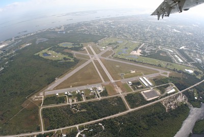
| SEBASTIAN MUNI SEBASTIAN FL |
| |
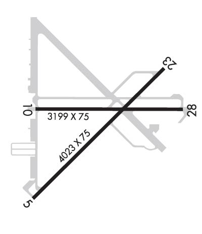
| Lat: N 2748.8 Long: W 08029.7 Elev: 22 Var: +06 Longest Runway: 4023 | ||
| CTAF: 123.05 | ||
| |||||||||||||||||||||||||||||||||||||||
| |||||||||||||||||||||||||||||||||||||||
| |||||||||||||||||||||||||||||||||||||||
| |||||||||||||||||||||||||||||||||||||||
| Rwy | Rwy | |||||||
| 4023x75 | 4023' | 4023x75 | 4023' | |||||
| 3199x75 | 3199' | 3199x75 | 3199' | |||||
| Runway ID | Single Wheel | Double Wheel | Double Tandem Wheel | Dual Double Wheel |
| 05/23 | 22,000 | N/A | N/A | N/A |
| 10/28 | N/A | N/A | N/A | N/A |
| These numbers are Advisory and are not limits. The Airport Manager should have more accurate Weight Limits | ||||
 Airport Diagram might not be current. | |
| Facility Name: | SEBASTIAN MUNI |
| City Name: | SEBASTIAN |
| County: | INDIAN RIVER |
| State abbrev: | FL |
| State Name: | FLORIDA |
| Ownership: | PUBLICLY OWNED |
| Use: | OPEN TO THE PUBLIC |
| Owner's Name: | CITY OF SEBASTIAN; CTC PERSON: BRIAN BENTON 772-638-8820 |
| Address: | 1225 MAIN STREET |
| SEBASTIAN, FL 32958 | |
| Owner's Phone: | 772-638-8820 |
| Manager's Name: | JEFFREY SABO |
| Address: | 202 AIRPORT DRIVE EAST |
| SEBASTIAN, FL 32958 | |
| Phone: | 772-228-7013 |
| FAA Region: | SOUTHERN |
| FAA Field Office: | ORL |
| Date | Sunrise | Sunset |
|---|---|---|
| 06/01/26 Monday | 6:26 | 20:14 |
| 06/02/26 Tuesday | 6:26 | 20:14 |
| 06/03/26 Wednesday | 6:26 | 20:14 |
| 06/04/26 Thursday | 6:26 | 20:15 |
| 06/05/26 Friday | 6:26 | 20:15 |
| 06/06/26 Saturday | 6:26 | 20:16 |
| 06/07/26 Sunday | 6:25 | 20:16 |
| 06/08/26 Monday | 6:25 | 20:17 |
| 06/09/26 Tuesday | 6:25 | 20:17 |
| 06/10/26 Wednesday | 6:25 | 20:18 |
| 06/11/26 Thursday | 6:25 | 20:18 |
| 06/12/26 Friday | 6:25 | 20:18 |
| 06/13/26 Saturday | 6:25 | 20:19 |
| 06/14/26 Sunday | 6:25 | 20:19 |
| Airport Attendance Schedule | MON-FRI 0800-1700 |
| Airport Status | OPERATIONAL (This Status can change at any time - please check NOTAMS) |
| Airport Lighting Schedule | PAPI OPRS CONSLY. ACTVT REIL RWY 5 & 23; MIRL RWY 5/23 - CTAF. |
| Airport Storage Available | Tie Downs |
| Extra Services Available | Charter, Flight Instruction, Parachute Jumping, Aircraft Rental |
| Wind Indicator | YES - (lighted) |
| Control Tower | NO |
| CTAF Frequency | 123.050 |
| Unicom Frequency | |
| Rotating Beacon Color | WG |
| Segmented Circle | Y-L |
| Landing Fee | NO |
| Airport Inspected | STATE - performed by STATE AERONAUTICAL PERSONNEL |
| Inspection Date | 01/10/2025 |
| Type of Fuel Available | Grade 100LL; -10FUEL 24 HR CREDIT CARD SVC AVBL. |
| Airframe Repair Service | MINOR |
| Power Plant Repair Service | MINOR |
| Latitude | N2748.8 |
| Longitude | W08029.7 (ESTIMATED) |
| Arpt Elevation | 21ft (SURVEYED) |
| Magnetic Variation | 06W |
| 1 miles W | of SEBASTIAN |
| Traffic Pattern Altitude | |
| Sectional Chart | MIAMI |
| Operations (Reported) | Yearly | Avg. Daily |
|---|---|---|
| General Aviation Transient | 0 | 0 |
| General Aviation Local | 0 | 0 |
| Air Taxi | 0 | 0 |
| Commerical | 0 | 0 |
| Commuter | 0 | 0 |
| Military | 0 | 0 |
| Aircraft based on Field | |
|---|---|
| General Aviation Singles | 0 |
| General Aviation Multi | 0 |
| Jet Aircraft | 0 |
| General Aviation Helicopters | 0 |
| Military Aircraft | 0 |
| Gliders | 0 |
| Ultralights | 0 |
| FSS on field | NO |
| FSS tie-in | SAINT PETERSBURG |
| FSS Phone | 1-800-WX-BRIEF |
| Who issues Notams | PIE |
| Notam D service at airport | YES |
| ARTCC Name | MIAMI |
| Airport Certification | |
| Aircraft Rescue & Firefighting Index | None |
| Airport of Entry | No |
| Custom Landing Rights | No |
| Joint Civil/Military | No |
| Military Landing rights | YES |
| NATIONAL PLAN OF INTEGRATED AIRPORT SYSTEMS (NPIAS) |
| GRANT AGREEMENTS UNDER FAAP/ADAP/AIP |
| SURPLUS PROPERTY AGREEMENT UNDER PUBLIC LAW 289 |
| ASSURANCES PURSUANT TO TITLE VI, CIVIL RIGHTS ACT OF 1964 |
| TREES & BRUSH IN ALL TRSN SFCS RWY 5/23. |
| NOISE ABATEMENT PROCS IN EFCT: CTC AMGR 772-633-0897. |
| IDENTIFICATION RQR FOR ARPT ACCESS. |
| EXTSV PRCHT OPNS. AVOID OVERFLYING ARPT DURG PRCHT OPNS. |
| FOR CD CTC PALM BEACH APCH AT 561-275-1430 |
Airport Communications & Frequencies:
| ||||||||||||
| Runway: 05 | Runway: 23 | ||
| Mag heading: | 51° | Mag heading: | 231° |
| Rwy Slope: | .08% Up | Rwy Slope: | -.08% Down |
| Approach: | Approach: | ||
| Pattern: | Left Traffic | Pattern: | Right Traffic |
| Markings: | NONPRECISION INSTRUMENT | Markings: | NONPRECISION INSTRUMENT |
| Marking Condition: | GOOD | Marking Condition: | GOOD |
| Arresting Dev: | Arresting Dev: | ||
| Lat & Long: | N2748.5 W08030.0 | Lat. & Long.: | N2749.0 W08029.5 |
| Elev: | 18.4 ft. MSL | Elev: | 21.5 ft. MSL |
| TCH: | TCH: | ||
| Visual Glide Path: | Visual Glide Path: | ||
| Displaced Threshold: | No | Displaced Threshold: | No |
| Touchdown Zone: | YES | Touchdown Zone: | YES |
| Touchdown Elev.: | 20.6 feet | Touchdown Elev.: | 21.5 feet |
| Visual Glide Slope: | 2-Light PAPI on LEFT side of Runway | Visual Glide Slope: | 2-Light PAPI on LEFT side of Runway |
| RVR Equipment: | RVR Equipment: | ||
| RVV Equipment: | NO | RVV Equipment: | NO |
| Approach Lights: | Approach Lights: | ||
| REIL: | YES | REIL: | YES |
| Centerline Lights: | NO | Centerline Lights: | NO |
| Touchdown lights: | NO | Touchdown lights: | NO |
| Runway Category: | Runway with a Non-precision Approach | Runway Category: | Runway with a Non-precision Approach |
| Declared Distances: | Declared Distances: | ||
| Obstructions: | TREES | Obstructions: | TREES |
| Marked: | NOT Marked/Lighted | Marked: | NOT Marked/Lighted |
| Clearance slope: | 24:1 | Clearance slope: | 29:1 |
| Obstruction height: | 37 feet AGL | Obstruction height: | 45 feet AGL |
| Dist. from runway: | 1090 feet | Dist. from runway: | 1520 feet |
| Centerline offset: | 120 left of centerline | Centerline offset: | 135 feet left of centerline |
| Comments: | Comments: |
| Runway: 10 | Runway: 28 | ||
| Mag heading: | 96° | Mag heading: | 276° |
| Rwy Slope: | .08% Up | Rwy Slope: | -.08% Down |
| Approach: | Approach: | ||
| Pattern: | Left Traffic | Pattern: | Right Traffic |
| Markings: | BASIC | Markings: | BASIC |
| Marking Condition: | GOOD | Marking Condition: | GOOD |
| Arresting Dev: | Arresting Dev: | ||
| Lat & Long: | N2748.8 W08030.0 | Lat. & Long.: | N2748.8 W08029.4 |
| Elev: | 18.3 ft. MSL | Elev: | 20.8 ft. MSL |
| TCH: | TCH: | ||
| Visual Glide Path: | Visual Glide Path: | ||
| Displaced Threshold: | No | Displaced Threshold: | No |
| Touchdown Zone: | YES | Touchdown Zone: | YES |
| Touchdown Elev.: | 21.1 feet | Touchdown Elev.: | 21.1 feet |
| Visual Glide Slope: | 2-Light PAPI on LEFT side of Runway | Visual Glide Slope: | 2-Light PAPI on LEFT side of Runway |
| RVR Equipment: | RVR Equipment: | ||
| RVV Equipment: | NO | RVV Equipment: | NO |
| Approach Lights: | Approach Lights: | ||
| REIL: | NO | REIL: | NO |
| Centerline Lights: | NO | Centerline Lights: | NO |
| Touchdown lights: | NO | Touchdown lights: | NO |
| Runway Category: | Runway with a Visual Approach | Runway Category: | Runway with a Visual Approach |
| Declared Distances: | Declared Distances: | ||
| Obstructions: | TREES | Obstructions: | TREES |
| Marked: | NOT Marked/Lighted | Marked: | NOT Marked/Lighted |
| Clearance slope: | 18:1; RWY 10 APRCH SLOPE 24:1 TO AER. | Clearance slope: | 23:1 |
| Obstruction height: | 29 feet AGL | Obstruction height: | 20 feet AGL |
| Dist. from runway: | 735 feet | Dist. from runway: | 665 feet |
| Centerline offset: | 125 left of centerline | Centerline offset: | 65 feet right of centerline |
| Comments: | Comments: |
Thanks for using FltPlan.com
all rights reserved © 1999-2026 by Flight Plan LLC
