| QUAKERTOWN QUAKERTOWN PA |
| |
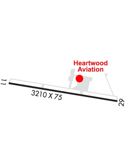
| Lat: N 4026.1 Long: W 07522.9 Elev: 525 Var: +12 Longest Runway: 3210 | ||
| Clr Del: 118.55 AWOS: 119.47 CTAF: 122.72 | ||
| |||||||||||||||||||||||||||||||||||||||||||||||||||||||||||||
| |||||||||||||||||||||||||||||||||||||||||||||||||||||||||||||
| |||||||||||||||||||||||||||||||||||||||||||||||||||||||||||||
| Rwy | Rwy | |||||||
| 3210x75 | 3210' | 3210x75 | 3020' | |||||
| Runway ID | Single Wheel | Double Wheel | Double Tandem Wheel | Dual Double Wheel |
| 11/29 | 12,000 | N/A | N/A | N/A |
| These numbers are Advisory and are not limits. The Airport Manager should have more accurate Weight Limits | ||||
 Airport Diagram might not be current. | |
| Facility Name: | QUAKERTOWN |
| City Name: | QUAKERTOWN |
| County: | BUCKS |
| State abbrev: | PA |
| State Name: | PENNSYLVANIA |
| Ownership: | PUBLICLY OWNED |
| Use: | OPEN TO THE PUBLIC |
| Owner's Name: | BUCKS COUNTY AIRPORT AUTH |
| Address: | OLD EASTON RD, PO BOX 1185 |
| DOYLESTOWN, PA 18901 | |
| Owner's Phone: | 215-345-1970 |
| Manager's Name: | PHIL REINFORD |
| Address: | 2425 MILFORD SQUARE PIKE |
| QUAKERTOWN, PA 18951 | |
| Phone: | 215-720-9715 |
| FAA Region: | EASTERN |
| FAA Field Office: | HAR |
| Date | Sunrise | Sunset |
|---|---|---|
| 06/01/26 Monday | 5:33 | 20:25 |
| 06/02/26 Tuesday | 5:33 | 20:26 |
| 06/03/26 Wednesday | 5:33 | 20:27 |
| 06/04/26 Thursday | 5:32 | 20:28 |
| 06/05/26 Friday | 5:32 | 20:28 |
| 06/06/26 Saturday | 5:32 | 20:29 |
| 06/07/26 Sunday | 5:31 | 20:29 |
| 06/08/26 Monday | 5:31 | 20:30 |
| 06/09/26 Tuesday | 5:31 | 20:31 |
| 06/10/26 Wednesday | 5:31 | 20:31 |
| 06/11/26 Thursday | 5:31 | 20:32 |
| 06/12/26 Friday | 5:31 | 20:32 |
| 06/13/26 Saturday | 5:31 | 20:33 |
| 06/14/26 Sunday | 5:31 | 20:33 |
| Airport Attendance Schedule | 7 Days A Week 0830-1700 |
| Airport Status | OPERATIONAL (This Status can change at any time - please check NOTAMS) |
| Airport Lighting Schedule | DUSK-DAWN. ACTVT REIL RWY 11 & 29; MIRL 11/29 - CTAF. |
| Airport Storage Available | Tie Downs |
| Extra Services Available | Flight Instruction, Aircraft Rental |
| Wind Indicator | YES - (lighted) |
| Control Tower | NO |
| CTAF Frequency | 122.725 |
| Unicom Frequency | 122.725 |
| Rotating Beacon Color | WG |
| Segmented Circle | NO |
| Landing Fee | NO |
| Airport Inspected | STATE - performed by STATE AERONAUTICAL PERSONNEL |
| Inspection Date | 09/09/2025 |
| Type of Fuel Available | Grade 100LL; -10100 LL AVBL 24 HRS SELF-SERVE CREDIT CARD. |
| Airframe Repair Service | MAJOR |
| Power Plant Repair Service | MAJOR |
| Latitude | N4026.1 |
| Longitude | W07522.9 (ESTIMATED) |
| Arpt Elevation | 525ft (SURVEYED) |
| Magnetic Variation | 12W |
| 2 miles W | of QUAKERTOWN |
| Traffic Pattern Altitude | |
| Sectional Chart | NEW YORK |
| Operations (Reported) | Yearly | Avg. Daily |
|---|---|---|
| General Aviation Transient | 0 | 0 |
| General Aviation Local | 0 | 0 |
| Air Taxi | 0 | 0 |
| Commerical | 0 | 0 |
| Commuter | 0 | 0 |
| Military | 0 | 0 |
| Aircraft based on Field | |
|---|---|
| General Aviation Singles | 0 |
| General Aviation Multi | 0 |
| Jet Aircraft | 0 |
| General Aviation Helicopters | 0 |
| Military Aircraft | 0 |
| Gliders | 0 |
| Ultralights | 0 |
| FSS on field | NO |
| FSS tie-in | WILLIAMSPORT |
| FSS Phone | 1-800-WX-BRIEF |
| Who issues Notams | UKT |
| Notam D service at airport | YES |
| ARTCC Name | NEW YORK |
| Airport Certification | |
| Aircraft Rescue & Firefighting Index | None |
| Airport of Entry | No |
| Custom Landing Rights | No |
| Joint Civil/Military | No |
| Military Landing rights | YES |
| NATIONAL PLAN OF INTEGRATED AIRPORT SYSTEMS (NPIAS) |
| GRANT AGREEMENTS UNDER FAAP/ADAP/AIP |
| ASSURANCES PURSUANT TO TITLE VI, CIVIL RIGHTS ACT OF 1964 |
| DEER ON & INVOF ARPT. |
| ACFT WITH WING SPAN GREATER THAN 54.5 FEET MUST COORDINATE WITH AMGR. |
| FOR CD CTC PHILADELPHIA APCH AT 800-354-9884. |
Airport Communications & Frequencies:
| |||||||||||||||||||
| Runway: 11 | Runway: 29 | ||
| Mag heading: | 111° | Mag heading: | 291° |
| Rwy Slope: | -.62% Down | Rwy Slope: | .62% Up |
| Approach: | Approach: | ||
| Pattern: | Left Traffic | Pattern: | Left Traffic |
| Markings: | NONPRECISION INSTRUMENT | Markings: | NONPRECISION INSTRUMENT |
| Marking Condition: | GOOD | Marking Condition: | GOOD |
| Arresting Dev: | Arresting Dev: | ||
| Lat & Long: | N4026.1 W07523.3 | Lat. & Long.: | N4026.1 W07522.6 |
| Elev: | 525.1 ft. MSL | Elev: | 505.1 ft. MSL |
| TCH: | 44 ft. AGL | TCH: | 48 ft. AGL |
| Visual Glide Path: | 4.00 degrees | Visual Glide Path: | 4.00 degrees |
| Displaced Threshold: | No | Displaced Threshold: | 190 feet |
| Touchdown Zone: | YES | Touchdown Zone: | YES |
| Touchdown Elev.: | 525.1 feet | Touchdown Elev.: | 524.7 feet |
| Visual Glide Slope: | 2-Light PAPI on LEFT side of Runway | Visual Glide Slope: | 2-Light PAPI on LEFT side of Runway |
| RVR Equipment: | RVR Equipment: | ||
| RVV Equipment: | NO | RVV Equipment: | NO |
| Approach Lights: | Approach Lights: | ||
| REIL: | YES | REIL: | YES |
| Centerline Lights: | NO | Centerline Lights: | NO |
| Touchdown lights: | NO | Touchdown lights: | NO |
| Runway Category: | Runway with a Non-precision Approach | Runway Category: | Runway with a Non-precision Approach |
| Declared Distances: | TORA:3210' TODA:3210' | Declared Distances: | TORA:3210' TODA:3210' |
| Obstructions: | TREES | Obstructions: | TREE |
| Marked: | NOT Marked/Lighted | Marked: | NOT Marked/Lighted |
| Clearance slope: | 5:1 | Clearance slope: | APCH SLP 15:1 TO 190 FT DTHR. |
| Obstruction height: | 77 feet AGL | Obstruction height: | 27 feet AGL |
| Dist. from runway: | 613 feet | Dist. from runway: | 213 feet |
| Centerline offset: | 275 right of centerline | Centerline offset: | 166 feet left of centerline |
| Comments: | Comments: |
Thanks for using FltPlan.com
all rights reserved © 1999-2026 by Flight Plan LLC